
THE CONSTRUCTION OF ONTOLOGICAL RETRIEVAL
SYSTEM FOR GEOLOGICAL MAP IN KOREA
Kwanghoon Chi and Jaehong Hwang
KIGAM(Korea Instituted Geoscience And Mineral resources)
30 Gajeong-dong, Yuseong-gu, Daejeon 305-350, South Korea
Keywords: Ontology model, retrieval system, Geologic map, GIS, Spatiotemporal object.
Abstract: Geological information is considered as one of the fundamentally national knowledge to be used in various
fields such as environmental pollution, ground disaster, natural disasters, exploration of natural resources
and so forth. However, it is difficult to find out the interesting data of end users in geology and geological
information has been losing as the time past. Also, geological data were produced by different institutes and
researchers for a long time. Investigated and published geological maps until a recent date have used
different geological boundaries, geological ages, colors, symbols, patterns and acronyms due to different
period because of a long period of geological investigation and a number of investigator, and moreover, two
adjacent geological maps are included many problems. Major area to solve these problems is data modeling.
Present data modeling are disappeared modelers' idea and are distorted by programmers. This also enables
data to play a part the level of information but it is impossible to precede with the level of knowledge this
problem occurred to be considered data model subsequently which is the most important coupling medium
between modelers and programmers. This research prepares as data model, geological symbology and
makes out GIS representation for digital geological map unit in Korea. To make out the spatiotemporal
information system for geological map in Korea: first, we limited to geologic world to geological map in
Korea. Second, we extract to rock units which is spatial object and to geologic time unit which is temporal
unit from geological map. Third, we considered the standardization of geological term in Korean and
English and make out geological terms for both spatial and temporal object. Fourth, we classify objects of
geologic map unit and make a guideline about the specification of spatiotemporal ontology model for digital
geological map unit. Finally, we construct the spatiotemporal retrieval system applied geological ontology
model.
1 INTRODUCTION
Geological map is an important data source using
the development of national territory and natural
resources, prevention of geological hazard and
environmental pollution, and other educational and
research purpose. However its both data modeling
and data integration have not yet been tried
systematically or comprehensively, thus there is
limited to its value and effective usage. Both
investigated and published geological map until a
recent date have used different geological
boundaries, geological ages, colors, symbols,
patterns and acronyms due to different period
because of a long period of geological investigation
and a number of investigators, finally, two adjacent
geological maps are included many problems.
Therefore it is important to the integration of
geological information so that it can be incorporated
with other IT and ET resources by, for example,
merging with other spatial information, producing
thematic map, or extracting additional
information the major study area to solve these
problems is data modelling.
This research prepares a geo-ontology model and
geological symbology and makes out GIS
representation for digital geological map unit in
Korea. To make out the spatiotemporal information
system for geological map in Korea: first, we limited
to geologic world to geological map in Korea.
Second, we extract to rock units which is spatial
object and to geologic time unit which is temporal
unit from geological map. Third, we considered the
standardization of geological term in Korean and
English and make out geological terms for both
spatial and temporal object. fourth, we classify
333
Chi K. and Hwang J. (2008).
THE CONSTRUCTION OF ONTOLOGICAL RETRIEVAL SYSTEM FOR GEOLOGICAL MAP IN KOREA.
In Proceedings of the Fourth International Conference on Web Information Systems and Technologies, pages 333-338
DOI: 10.5220/0001530903330338
Copyright
c
SciTePress

objects of geologic map unit and make a guideline
about the specification of spatiotemporal ontology
model for digital geological map unit. Finally, we
construct the spatiotemporal retrieval system applied
geological ontology model.
2 THE SPECIFICATION OF
SPATIOTEMPORAL
ONTOLOGY MODEL FOR
GEOLOGICAL MAPS(DRAFT)
The specification of spatiotemporal ontology model
for geological maps limited to the scope of the
geological world to digital geological maps in
Korea, and extracted geological ages as time units
and rock units as spatial units. For the rock unit
ontology, we selected English-Korean lithological
terms found in digital geological maps and,
considering the standardization of terms, we
classified rock units, assigned classification
identifiers, and defined the concepts of terms.
2.1 Extraction of Spatiotemporal
Objects from Geological Maps
The classification of rock units of digital geological
maps aims at digitalization in lithologically uniform
minimum map unit. The classification of digital
geological map in the minimum unit divided space
into rock units and time into geological ages, and
extracted the objects of rock units and geological
ages existing in Korean digital geological maps.
First, objects existing in digital geological maps
were converted into the minimum units, and 1961
fields of rock layer names were mapped to the
specification of rock units ontology made through
this research. In addition, for standardizing terms in
object extraction, English and Korean terms were
sorted out and classified hierarchically. For making
the ontology specification, we structured the
conceptual definitions of terms, the hierarchical
structure of terms related to rocks and geological
ages, and the relation of inclusion.
Rock units of digital geological maps were classified
first into sedimentary rocks and sediments,
metamorphic rocks and igneous rocks, and then
subordinate classification was made for applicable
scopes. In addition, geological ages in digital
geological maps were classified first into the
Precambrian Eon and the Cambrian Eon, and then
subordinate classification was made for applicable
scopes.
In extracting spatiotemporal ontology objects from
geological maps, we analyzed Korean digital
geological maps in 1961 rock layer units and
organized them fittingly to the Korean system at the
level of undergraduate senior students, referring to
Introduction to Geology, Loren A. Raymond’s
Petrology, Geologic Map Unit Classification,
ver.6.1) of USGS, and GeMPeT (Geoscience,
Mineral, Petrology Thesaurus) in Australia.
2.2 Development of a Spatio Temporal
Ontology Model of Geological
Maps
We extracted geological unit objects for rocks and
geological ages from geological maps, and defined
and classified geological terms for the geological
units. In addition, we formulated a rock-time unit
ontology model for the geological units. In this
study, a spatiotemporal ontology model means a
sophisticated model upgraded from data to
knowledge. The geological map ontology model can
be defined as a set of terms for expressing space
objects of rock units and time objects of geological
ages as well as the system of contents and structures.
In addition, it includes color and pattern symbols
mapped one-to-one to spatiotemporal objects.
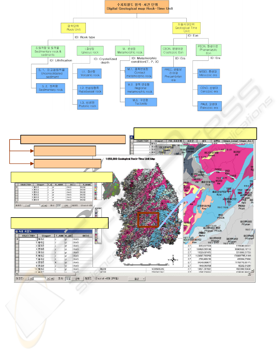
In rock units classification, S, I and M were
assigned as the identifiers of sedimentary rocks and
sediments, igneous rocks, and metamorphic rocks,
respectively, and sub-class rocks followed the
identification information. Based on the basic
classification, a hierarchical classification system
was prepared. Geological age classification was
made, referring to the Korean geological time scale
(Geological Society of Korea) and geological
dictionaries, by extracting geological age objects of
primary, secondary and tertiary classification items,
and then quaternary classification was added in
consideration of international geological time scale
standard in the future (Figure1).
3 ONTOLOGIC DATABASE OF
GEOLOGICAL MAPS
The basic data used in the spatiotemporal database
of geological maps are digital topographical maps
and digital geological maps. (figure 2).
Maps were extracted administrative districts such as
counties, towns, villages and provinces in the form
of polygons and they were used as data, and from
digital geological maps was built a database using
the spatiotemporal ontology model. First, we
WEBIST 2008 - International Conference on Web Information Systems and Technologies
334
corrected errors in the attribute tables and space data
of existing digital geological maps. Second, we
redefined the database schema, adding the fields of
rock units, geological age units, abbreviations of
geological ages, abbreviations of rocks, etc.
In order to build the digital geological map
database, first, we examined and revised the attribute
tables of map sheets forming digital geological
maps. In addition, the index map field was added to
identify map sheets, and the table was redefined by
adding the fields of rock units, geological age units,
abbreviations of geological ages and rocks existing
in the developed spatiotemporal ontology model.
Second, spatial data forming the Korean territory
were converted into a consistent format. Third,
Geodatabase was built by integrating the adjacent
abutting boundaries of polygon feature classes for
each map sheet. Fourth, database was built by
inserting the contents of the developed
spatiotemporal ontology model into the redefined
digital geological map table. Fifth, the patterns and
colors of rocks were refined using the symbology
unit of the spatiotemporal ontology model, and
applied to the geological map schema.
Figure 1: Spatiotemporal ontology model for the geological map in Korea (the basic diagram).
Figure 2: The table and spatial representation of spatiotemporal database for geological map in Korea.
The table of geologic rock unit
The table of geologic age
Construction of seamless map
Topograpic map
Geological map
T
he table of Administrative unit
THE CONSTRUCTION OF ONTOLOGICAL RETRIEVAL SYSTEM FOR GEOLOGICAL MAP IN KOREA
335
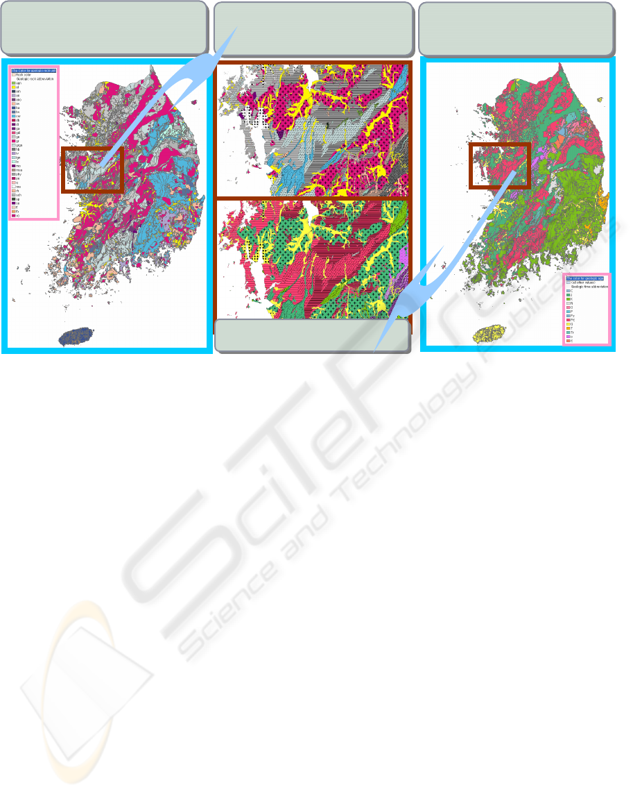
Figure 3: The representation of colors and patterns (a. representation of geologic rock color; b. Mixture of geological color
and pattern; c. representation of geologic rock color).)
4 REPRESENTATION AND
SPATIOTEMPORAL QUERY
FOR GEOLOGICAL MAP
This research prepares the specification of
spatiotemporal ontology and symbology for
geological map and makes out GIS representation
for digital geological map unit in South Korea.
We redefined the database schema, adding the
fields of rock units, geological age units,
abbreviations of geological ages, abbreviations of
rocks, etc. and make out the specification of
spatiotemporal ontology model for rock unit, time
unit and symbology unit and visualize a variety of
representation for geological map using this
model(figure 3). To make out spatiotemporal DB
integration: first, we need to find out the major
geological term, symbol, pattern and abbreviation
correctly in consideration of internet keyword which
is both Korean and English. Second, we classifies
geological term in hierarchy with spatiotemporal
classification and prepare geological map
identifiers(Geologic Map UFID) Finally,
we construct the GIS DB applied geological
ontology model and symbology. Therefore, it is
possible to query spatiotemporal units on the
integrated database of geological maps(figure 4).
5 CONCLUSIONS
This paper carry out the conceptualization and
generalization of geological information to construct
GIS based Geological information system through
the development of spatiotemporal ontology model
for geological maps. We have constructed
spatiotemporal database using geological object
units and thus make it possible to corporate with
other spatial information or to distribute and make
the best use of geological information.
This research aims to develop knowledge-based
geological information system by standardizing the
spatiotemporal concept units on the geological map
and constructing systematic database. We expect
that the use of spatiotemporal ontology model for
geological map can avoid computerization costs and
spatiotemporal query costs.
This research prepares the specification of
spatiotemporal ontology and symbology for
geological map and makes out GIS representation
for digital geological map unit in South Korea.
a
a
.
.
r
r
e
e
p
p
r
r
e
e
s
s
e
e
n
n
t
t
a
a
t
t
i
i
o
o
n
n
o
o
f
f
g
g
e
e
o
o
l
l
o
o
g
g
i
i
c
c
r
r
o
o
c
c
k
k
c
c
o
o
l
l
o
o
r
r
b
b
.
.
m
m
i
i
x
x
t
t
u
u
r
r
e
e
o
o
f
f
g
g
e
e
o
o
l
l
o
o
g
g
i
i
c
c
c
c
o
o
l
l
o
o
r
r
a
a
n
n
d
d
p
p
a
a
t
t
t
t
e
e
r
r
n
n
C
C
h
h
u
u
n
n
g
g
n
n
a
a
m
m
a
a
r
r
e
e
a
a
c
c
.
.
r
r
e
e
p
p
r
r
e
e
s
s
e
e
n
n
t
t
a
a
t
t
i
i
o
o
n
n
o
o
f
f
g
g
e
e
o
o
l
l
o
o
g
g
i
i
c
c
t
t
i
i
m
m
e
e
c
c
o
o
l
l
o
o
r
r
WEBIST 2008 - International Conference on Web Information Systems and Technologies
336
To make out the spatiotemporal information
system for geological map in Korea: First, we
limited to geologic world to geological map in
Korea. Second, we extract to rock units which is
spatial object and to geologic time unit which is
temporal unit from geological map. Third, we
considered the standardization of geological term in
Korean and English and make out geological terms
for both spatial and temporal object. Fourth, we
classify objects of geologic map unit and make a
guideline about the specification of spatiotemporal
ontology model for digital geological map unit.
Finally, we construct the spatiotemporal retrieval
system applied geological ontology model.
The conclusion and expectation effect of this
research is as followings: First, We construct
seamless map through the integration of geological
map and the construction of database. Second, we
make out the specification of spatiotemporal
ontology model for rock unit, time unit and
symbology unit and visualize a variety of
representation for geological map using this model.
The third, we extract to rock unit which is spatial
objects and to geologic time unit which is temporal
objects from geological map. It is possible to query
spatiotemporal units on the integrated database of
geological maps. Forth, we are spatially mapping for
spatiotemporal ontology concepts in the geological
map by extracting UFIDs (Unified Feature
Identifiers) from the spatiotemporal ontology model
for geological map in Korea. These extracted
identifiers are used to other ubiquitous systems.
Finally, We represents the appearances of geological
map using colors, patterns, symbols, abbreviations
included the specification of spatiotemporal
ontology model for geological map.
ACKNOWLEDGEMENTS
This research was supported by a grant (NEMA-07-
NH-Article) from the Natural Hazard Mitigation
Research Group, National Emergency Management
Agency.
REFERENCES
Baldonado, M., Chang, C.-C.K., Gravano, L., Paepcke, A.,
1997. The Stanford Digital Library Metadata
Architecture. Int. J. Digit. Libr. 1 108–121
British Geological Survey(BGS), 2005. Proposals for the
British Geological Survey Core Strategic
Programme(2005-2010). pp.1-9
British Geological Survey (BGS), 2007. The British
Geological Survey Lexicon of Named Rock Units
(Unpublished Webpage: http://www.bgs.ac.uk/scripts
/lexicon/home.cfm). 2007
Europe Geological Surveys (Unpublished Webpage:
www.eurogeosurveys.org). 2007
Figure 4: The representation of colors and patterns (a. representation of geologic rock color; b. Mixture of geological color an
d
pattern; c. representation of geologic rock color).)
b
b
.
.
q
q
u
u
e
e
r
r
y
y
o
o
f
f
g
g
e
e
o
o
l
l
o
o
g
g
i
i
c
c
a
a
l
l
a
a
g
g
e
e
-
-
J
J
U
U
R
R
A
A
S
S
I
I
C
C
p
p
e
e
r
r
i
i
o
o
d
d
a
a
.
.
q
q
u
u
e
e
r
r
y
y
o
o
f
f
g
g
e
e
o
o
l
l
o
o
g
g
i
i
c
c
a
a
l
l
r
r
o
o
c
c
k
k
-
-
G
G
R
R
A
A
N
N
I
I
T
T
E
E
THE CONSTRUCTION OF ONTOLOGICAL RETRIEVAL SYSTEM FOR GEOLOGICAL MAP IN KOREA
337

ESRI, 2005, Geoprocessing Commands Quick Reference.
ArcGIS 9 Guide book, 1-81.
Geological Survey of Japan (GSJ). 2007. (Unpublished
Webpage: www.gsj.jp).
Geoscience Australia(GA). 2007. (Unpublished Webpage:
www.ga.gov.au).
United States Geological Survey, 2007. Geologic Map
Unit Classification, ver.6.1
U.S. Geological Survey (USGS). 2005. Geography for a
Changing World (USGS Strategic Plan 2005-2015).
1997. pp.1-8
WEBIST 2008 - International Conference on Web Information Systems and Technologies
338
