Stereo and LIDAR Fusion based Detection of Humans and Other
Obstacles in Farming Scenarios
Stefan-Daniel Suvei, Frederik Haarslev, Leon Bodenhagen and Norbert Kr
¨
uger
SDU Robotics, University of Southern Denmark, Campusvej 55, 5230 Odense M, Denmark,
Keywords:
Agricultural Robot, Sensor Fusion, Neural Network.
Abstract:
In this paper we propose a fusion method which uses the depth information acquired from a LIDAR sensor
to guide a block matching stereo algorithm. The resulting fused point clouds are then used for obstacle
detection, either by processing the raw data and clustering the protruding objects in the scene, or by applying
a Convolutional Neural Network on the 3D points and labeling them into classes. The performance of the
proposed method is evaluated by carrying out a series of experiments on different data sets obtained from the
SAFE robotic platform. The results show that the fusion algorithm significantly improves the F1 detection
score of the trained networks.
1 INTRODUCTION
In recent years, a variety of agricultural robotic so-
lutions have been proposed with the purpose of im-
proving farm productivity. The prototypes are gener-
ally targeted towards applications such as fertilizing
and/or application of pesticides (Sharma and Borse,
2016), fruit picking (Song et al., 2016) or autonomous
weeding (Nakamura et al., 2016), thus allowing the
farmers to reduce the environmental impact and in-
crease the efficiency and precision of operations.
Farming requires a large variety of processes to
be carried out in order to obtain the required result.
In many of these operations an important element is
accurately traversing the field or the crop rows. As
such, the field robot has to not only drive and reach
the correct area of the field, but do so while avoiding
the humans or animals that could be present and also
any obstacle that might damage the system, such as
trees or fences.
Hence guidance of the agricultural robot is an im-
portant task. A common way of doing this is to guide
the vehicle along a pre-defined path based on input
from the global positioning system (GPS). Alterna-
tively the vehicles can be operated relative to the crop
lines, using machine vision (English et al., 2014).
While these options address some of the problems
outlined above, they are not necessarily the best solu-
tions in terms of precision and safety of the platform.
Another option is to fully automate the robot by using
various sensors in parallel and thus improving the sys-
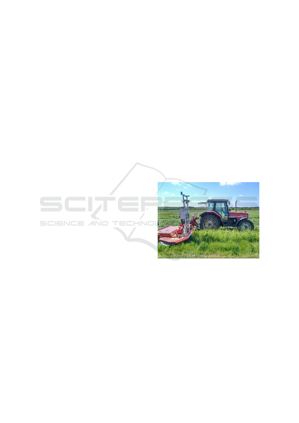
Figure 1: The SAFE robotic platform, with the Sensor Kit
mounted on the blade of the tractor for a better visibility.
tem’s representation of the surrounding environment,
which can then be used for navigation, detection of
humans and obstacle avoidance.
This paper proposes a vision based 3D scene re-
construction method to generate dense point clouds,
which are processed and used to detect the protrud-
ing objects that are detected in front of the robot. The
advantage of our method is that it fuses the data cues
from both the LIDAR and the stereo camera on a low
level, thus profiting from the high reliability of the
LIDAR and the high density of the stereo data and
leading up to denser, more accurate point clouds. Ad-
ditionally, the resulting point clouds are used to detect
and label obstacles in the scene, by using the PointNet
model.
166
Suvei, S-D., Haarslev, F., Bodenhagen, L. and Krüger, N.
Stereo and LIDAR Fusion based Detection of Humans and Other Obstacles in Farming Scenarios.
DOI: 10.5220/0006619801660173
In Proceedings of the 13th International Joint Conference on Computer Vision, Imaging and Computer Graphics Theory and Applications (VISIGRAPP 2018) - Volume 4: VISAPP, pages
166-173
ISBN: 978-989-758-290-5
Copyright © 2018 by SCITEPRESS – Science and Technology Publications, Lda. All rights reserved

The main contribution of this paper is generating
dense and accurate fused point clouds, using a sped up
version of a LIDAR-Stereo fusion algorithm, which
are then used by a PointNet based neural network 3D
recognition system, in order to label obstacles in out-
door scenarios. The results show that by using the
fused point clouds, better detection and labeling ac-
curacy is achieved.
The remainder of the paper is organized as fol-
lows: In Section 2, we describe related methods of
fusing different vision sensors for scene reconstruc-
tion and neural network training. Section 3 describes
the experimental platform used for our tests. The fu-
sion algorithm is described in Sections 4, while Sec-
tion 5 contains the Obstacle Detection methodology.
Section 6 shows the results of the methods, while the
concluding remarks are presented in Section 7.
2 RELATED WORK
In order to allow an agricultural robot to au-
tonomously perform tasks in an outdoor environment,
an accurate 3D scene reconstruction and interpreta-
tion must first be ensured. As discussed above, 3D
scene reconstruction can be achieved by fusing the
data streams of multiple vision sensors. This is a topic
that has been investigated before in literature and two
main fusion techniques can be identified: a posteriori
and a priori fusion.
In the a posteriori fusion method, the final result
of the vision system is improved by combining the
disparity map of the passive sensor (e.g. a stereo cam-
era) with the data from an active sensor (e.g. LIDAR,
2D scanner, etc.). The fusion can be done either di-
rectly at the object level (Zhang et al., 2014) or by
constructing a cost map (Romero et al., 2016), where
the two types of sensors have different weights ac-
cording to the level of trust in each specific region.
Another option is to build an elevation model by eval-
uating the consensus of the stereo and laser signals, as
shown in (Aeschimann and Borges, 2015).
In the case of the a priori technique, the stereo
matching process is directly guided by the active sen-
sor’s depth information. In (Badino et al., 2011), LI-
DAR depth data is used to improve the stereo compu-
tation process by limiting the disparity search space
of the stereo matching algorithm. Similarly, in (So-
manath et al., 2013) the Kinect depth information is
used to determine the data and smoothness costs of
the energy minimization function used for the global
stereo matching algorithm.
Accurate obstacle detection is often the main goal
of doing scene reconstruction and machine learn-
ing. For 2D data this can be done using a Convolu-
tional Neural Network (CNN) by predicting bound-
ing boxes (Redmon and Farhadi, 2016) or by seman-
tically segmenting the image to produce pixel labels
(Long et al., 2014; Teichmann et al., 2016). In (Qi
et al., 2016) they extend this idea to 3D. Their Point-
Net model is able to semantically segment unordered
point clouds to produce point-wise class labels.
In this paper, we apply an a priori method which
improves the stereo matching process by limiting the
disparity search range around the depth value ob-
tained from a LIDAR sensor. This method is a re-
finement of the algorithm in (Suvei et al., 2016). In
contrast to (Somanath et al., 2013) and (Badino et al.,
2011), our method focuses on the Block Matching lo-
cal stereo matching algorithm, due to the advantage
of scaling well for large images and for requiring less
memory and computation time. In this way the LI-
DAR point cloud is used to guide the Block Match-
ing process, leading to a better matching quality and
a denser disparity map and point cloud. The resulting
point cloud is then segmented using PointNet, and the
output is used to detect and label obstacles (e.g. hu-
mans, trees) in the scenes. Compared to (Qi et al.,
2016), our method uses a smaller feature vector and
is applied on outdoor data.
3 EXPERIMENTAL SETUP
The data recordings have been done using the SAFE
Platform and the Sensor Kit (Kragh et al., 2016) as
shown in Figure 1. This is a multi-sensor platform,
consisting of a Multisense S21 stereo camera, a Velo-
dyne HDL-32E LiDAR sensor, a Flir A65 thermal
camera, an RGB camera and a radar. The purpose
of the Sensor Kit is to be used in outdoor environ-
ments on autonomous tractors to ensure safety of the
humans in the field and that of the system itself. For
our specific algorithm, only the stereo camera and
LIDAR inputs are used. The LIDAR sensor rotates
at a frequency of 10 Hz and it can record 700.000
points/second, using 32 horizontal scan beams and a
horizontal field of view of 360
◦
. The stereo system
uses two S7 stereo ranging sensors, which operate at
15 Hz and output images with a 1024x544 pixels res-
olution.
4 SENSOR DATA FUSION
The sensor fusion algorithm used in this paper is our
Guided Block Matching (GuBM), presented in (Suvei
et al., 2016). The algorithm has been updated to run
Stereo and LIDAR Fusion based Detection of Humans and Other Obstacles in Farming Scenarios
167
(a) LIDAR disparity map(SDM)
(b) Dilated LIDAR disparity map
Figure 2: Visualization of the LIDAR disparity map - with
and without dilation.
on ROS (Quigley et al., 2009) and improved by us-
ing the OpenMP (Dagum and Menon, 1998) library
to parallelize some of the processes, which leads to a
76.9% increase in run time. With the purpose of of-
fering more context to the overall work, in the follow-
ing paragraphs we will restate details regarding the
GuBM method.
As mentioned, due to its low computation time
and good resolution scaling, one of the most popular
local stereo algorithms is Block Matching (BM),
where the depth information is computed by deter-
mining the pixel-distances of similar pixel-regions in
the stereo images pair. In essence, the disparity of a
pixel is computed by defining a reference block of
neighboring pixels in the left image and then search-
ing for the most similar block in the right image,
which will reference the corresponding matching
pixel. Because the images are rectified beforehand,
pixel-features in the left image will be in the same
pixel rows than in the right image. This restricts the
search to only horizontal lines and transforms the
correspondence problem into a 1D search problem
which guarantees to find the solution (i.e. best-
matching block). However, because the similarity
check is done for all the pixels, the computation load
can be high and it increases with the image resolution.
Fusion Algorithm: Choosing the disparity search
interval D is crucial, because it directly influences the
computation of the stereo matching process - a small
interval will make the algorithm skip some match-
ing pixels, while a too large interval will increase
the computation time and increase the risk of having
wrong matches. Our method proposes the use of the
depth information from the LIDAR sensor to limit the
disparity search interval around an expected value for
each pixel. An important step in doing this is to effi-
ciently transform the depth data from the LIDAR into
a dense disparity range. Using the external calibration
of the two sensors, each point p ∈ IR
3
from the active
sensor’s point cloud is mapped to the left camera’s
coordinate system. The depth ranges are transformed
into disparities by using the corresponding image dis-
placements available from the stereo camera’s cali-
bration information file as follows:
d
L
= B f /Z (1)
where d
L
is a LIDAR obtained disparity value, B is
the baseline, f is the focal length and Z is the depth
value. The resulting Sensor Disparity Map (SDM)
can be observed in Figure 2(a).
Because the depth measurements of the LIDAR
sensor are of low resolution, the obtained disparity
map can be sparse. To compensate for this, a mor-
phological dilation operator is applied. A rectangular
structuring element of size 3x3 pixels is used, with
a number of 11 iterations. These values were chosen
such that the dilated regions around the original points
would barely overlap (see Figure 2(b)).
Using the dilated SDM and the d
L
values, we
can now perform so called ”Guided Block Match-
ing” (GuBM). First, D becomes D = [d
L
− R,d
L
+ R],
where R is a constant fixed at the beginning of the
algorithm with the purpose of limiting the disparity
range around d
L
. In the areas where there are no
available d
L
values, the full disparity interval D is
used. Missing data caused by occlusions, texture-
less areas or even light conditions will still generate
empty regions in the Stereo Disparity Map (StDM).
These situations can be accounted for by applying
Guided Block Matching with gap Filling (GuBM-F).
In GuBM-F, if GuBM fails to compute a disparity
value for a pixel, then the final stereo disparity value
d
S
is assigned from the computed dilated LIDAR dis-
parity map, if the depth information is available for
that specific pixel. A failed StDM and the resulting
GuBM-F dense disparity map is shown in Figure 3(a).
The evaluation of the algorithm shows that, aside
from leading to a much denser disparity map and
point cloud, a secondary advantage of the GuBM-F
method is that the LIDAR sensor acts as a double-
checker for the stereo camera. This means that when
stereo completely fails to do matching (e.g. due to
VISAPP 2018 - International Conference on Computer Vision Theory and Applications
168
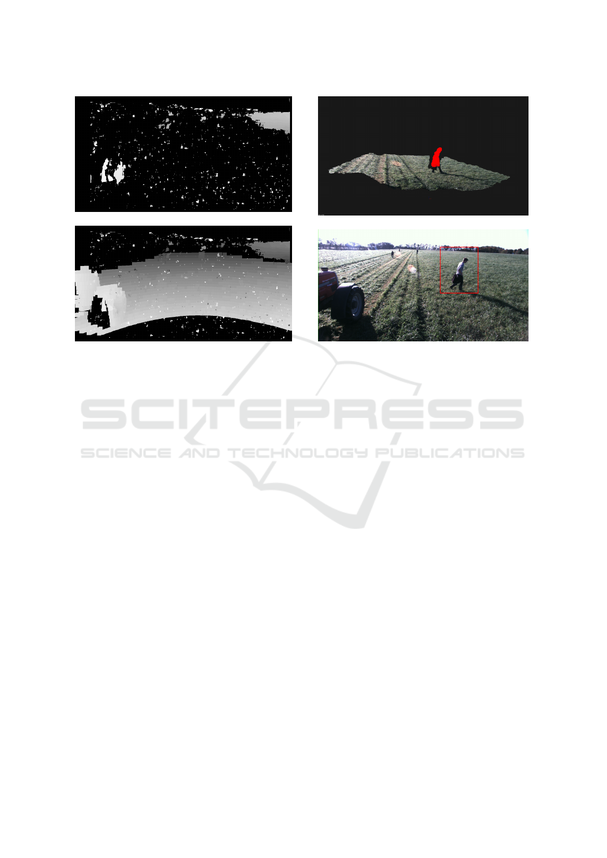
(a) Failed stereo disparity map
(b) GuBM-F disparity map
Figure 3: Result of GuBM-F, when stereo matching fails
due to movement of the camera.
light conditions or movement of the platform), the LI-
DAR data can still be used to generate a point cloud
of the scene (see Figure 3(b)) and as a result obstacle
detection and labeling can still be carried out.
5 OBSTACLE DETECTION
3D scene reconstruction is a vital component in agri-
cultural robotics, because it enables the robot to take
the appropriate actions accordingly to what is happen-
ing around it. To that extent, the purpose of obtaining
a dense point cloud via the GuBM-F method is to en-
hance the result of the obstacle detection process. The
result of the obstacle detection methods can be further
used by the decision layer of the robot, which could
issue a warning or potentially compute the best next
action.
In this paper we tackle the problem of obstacle
detection in two ways: via Data Clustering and by
using a CNN. The following subsections describe
these two methods in greater detail.
5.1 Data Clustering
The data clustering is done by processing the GuBM-
F resulted point cloud using different Point Cloud Li-
brary (PCL) (Rusu and Cousins, 2011) methods, with
(a) Cluster visualization
(b) 2D label of cluster
Figure 4: Result of 2D label generation process.
the intent of detecting any protruding object in the
scene (humans, trees, etc.) and marking them on the
2D image by attaching a bounding box around the ob-
stacle. The first step in generating the boxes is remov-
ing the tractor points from the disparity map because
the detection of the tractor is not important for the end
result. After generating the point cloud, Plane Model
Segmentation is applied with a plane fitting tolerance
of 0.35 m. The tolerance value was chosen to account
for the fact that the grass can have patches which are
bigger and therefore it will never be a perfect plane.
This will remove all the ground points that are within
the specified tolerance. The remaining points repre-
sent the elements in the scene that are protruding from
the ground. Using the PCL Euclidean Cluster Ex-
traction algorithm, they are clustered into obstacles,
with a tolerance of 0.3 m. The minimum accepted
number of points for a cluster is 600, while the maxi-
mum is 12.000. The clusters are then reprojected into
2D onto the left image plane, where bounding boxes
are attached around them (see Figure 4(b)). The clus-
ters can also be visualized in the original point cloud,
as shown in Figure 4(a). The method is not aware
which type of obstacle is there, only that an obstacle
is present.
The advantage of this method is that it can be
used to improve the computation time of 2D based
CNN labeling methods, such as YOLO (Redmon and
Farhadi, 2016), by applying them directly onto the
bounded regions, instead of on the entire image. The
Stereo and LIDAR Fusion based Detection of Humans and Other Obstacles in Farming Scenarios
169
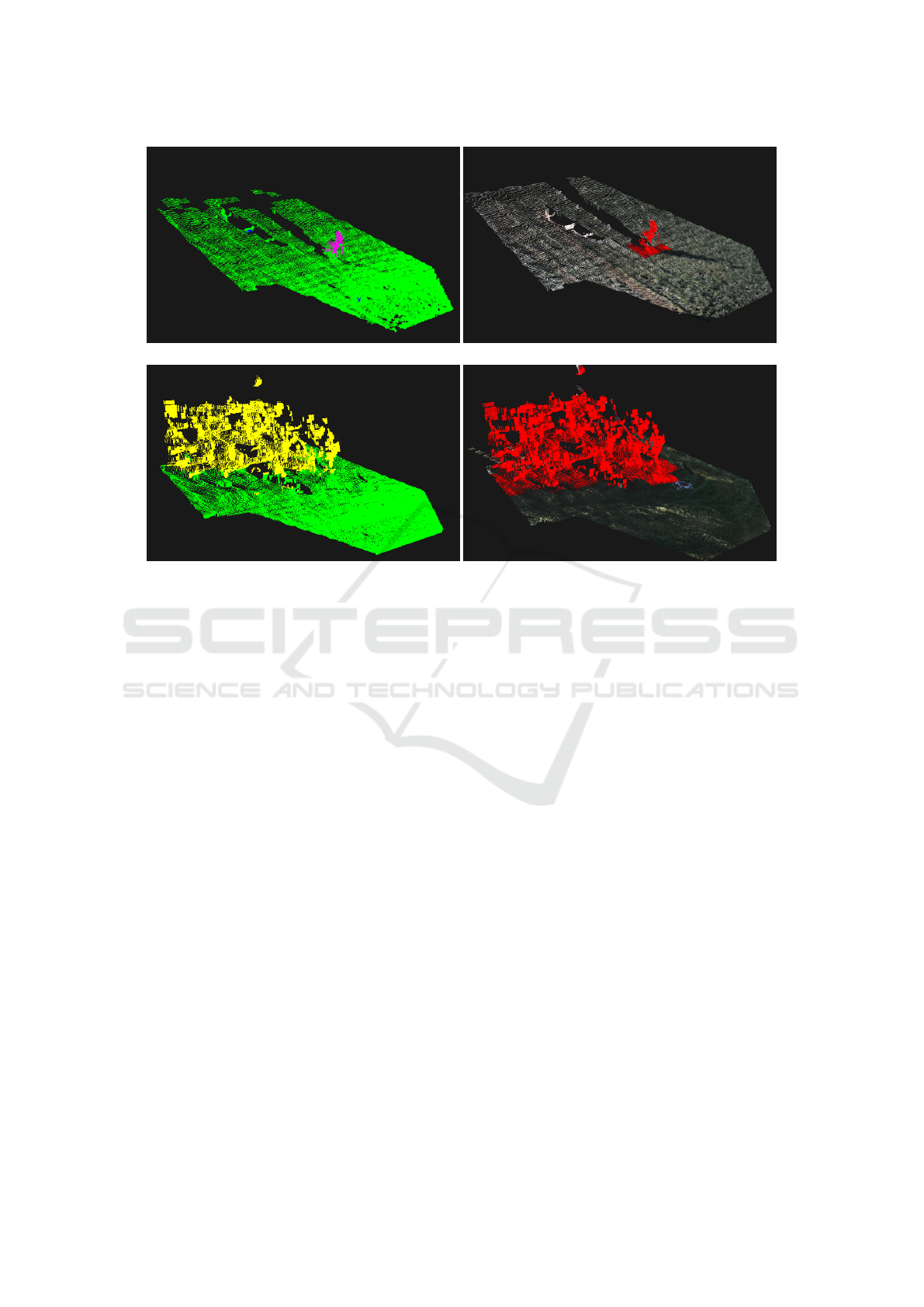
(a) Segmentation of humans (b) Detection of humans
(c) Segmentation of trees (d) Detection of trees
Figure 5: The segmentation and the detection of obstacles. Here green points corresponds to grass, purple points to human,
yellow points to tree and blue points to clutter.
disadvantage is that it is dependent on the system be-
ing able to produce a good-quality point cloud.
5.2 PointNet
As an alternative to the 2D labeling method, the point
clouds are also processed with the PointNet (Qi et al.,
2016) neural network. PointNet can semantically seg-
ment unordered point clouds by passing them through
the network, producing a class label for each point.
Training: The network is trained using a dataset
created with the Sensor Kit. 200 scene clouds have
been annotated into the classes grass, human, tree and
clutter. The clutter class is used for the tractor if it
has not been completely removed, as well as artifacts
from matching errors. The scene is cropped to 24×12
meters and Plane Model Segmentation is then used to
remove as many grass points as possible. The left-
over points are clustered using the before mentioned
data clustering and each cluster is assigned one of the
classes.
The input size of the network is set to n points.
To accommodate this each scene is split into b × b
blocks with a stride of s – resulting in overlap be-
tween the blocks if b > s. Blocks containing more
than n points are subsampled at random, while blocks
containing less have random points duplicated. If b is
large there will be a lot more than n points in a block,
resulting in a significant amount of information being
thrown away. Therefore, when b is large each block
is resampled c times, creating c different blocks per
position. If there are less than 100 points in a block
it is discarded. The data sets have an over representa-
tion of grass points in the scenes and are thereby not
balanced. Therefore, blocks containing only grass are
discarded with a probability of 80%.
The authors of PointNet use a 9-dimensional fea-
ture vector per point: xyz values of the point relative
to the block center, rgb values from 0-1, as well as xyz
relative to the whole scene, where {0,0,0} is down in
the bottom left corner, and {1,1,1} is up in the far
right corner. This works well for indoor scenes as
this allows the network to learn that e.g. blackboards
usually are located on the edge of rooms. This is ir-
relevant in our domain as all classes can be located
throughout the whole scene. Therefore the feature
vector is shortened to only consist of the xyz values
relative to the block and the rgb values.
All networks were trained using adam optimizer
with a batch size of 24 and momentum of 0.9, and
an initial learning rate of 0.001 which decays every
300.000 steps by a rate of 0.5.
Detection: When a scene is segmented it is used
for obstacle detection. This is done by first extract-
VISAPP 2018 - International Conference on Computer Vision Theory and Applications
170

Table 1: Results of the data clustering method, using Block Matching and GuBM-F generated point clouds. The Processed
Frames contains the total number of stereo pairs that where processed. The Human frames column shows how many of the
total processed frames contain a human in the scene. The Labeled Frames column shows for how many of the scenes data
clustering could be applied. The Detected humans column contains the total number of correctly labeled human frames, while
the Accuracy column gives the percentage of correctly detected humans.
BM Processed frames Human frames Labeled frames Detected humans Accuracy
Set 1 82 25 23 22 88%
Set 2 48 23 19 18 78%
Set 3 75 11 9 5 45%
GuBM-F Processed frames Human frames Labeled frames Detected humans Accuracy
Set 1 82 25 28 24 96%
Set 2 48 23 20 18 78%
Set 3 75 11 29 8 72%
ing all the human and tree points into separate clouds.
The separated clouds are then projected to the XZ
plane into 1 × 1 meter grids creating an occupancy
map. If a grid cell contains 800 points or more, it is
marked as containing an obstacle of the given class.
Figure 5 shows the results of semantic segmentation
and obstacle detection in scenes containing a human
or trees.
6 RESULTS
The proposed GuBM-F method has been imple-
mented using and modifying the OpenCV (Bradski,
2000) specific Block Matching method. The stereo
cameras and the LIDAR sensor have been appropri-
ately calibrated beforehand.
To measure the time required for our method, the
algorithm is tested on 15 consecutive scene frames,
with a resolution of 1024x544 pixels, on an Intel Core
i5-4210U, 1.7GHz machine. On average, the standard
Block Matching algorithm has a runtime of 0.176 s.
The introduction of the fusion component leads to an
increase of the stereo matching time and as a result,
the average runtime of GuBM-F is 0.292 s per frame.
To verify the overall performance and to quantify
the impact of the fusion method, both the Data Clus-
tering and the PointNet detection were tested on the
point clouds generated by the GuBM-F method and
the standard OpenCV Block Matching function.
6.1 Data Clustering Results
For the Data Clustering algorithm, three different data
sets (i.e. rosbags) were used for testing:
Set 1: Scenes with a human traversing the field, in
front of the robot.
Set 2: Scenes with two humans walking in the field.
Set 3: Scenes with 5 humans walking in the field.
Since the scenes contain no other obstacles than
the mentioned humans, the results for detection on
humans is identical with obstacle detection.
On average, the Data Clustering algorithm has a
runtime of 0.097 s. The results of the tests are shown
in Table 1. As mentioned before, there are cases in
which the stereo matching process completely fails to
generate a point cloud, due to the movement of the
robot or the direct sun light. This, in return, heavily
affects the accuracy of the labeling process, which re-
lies on detecting clusters in the scene. This problem
is particularly obvious when looking at the results of
Set 3, where the GuBM-F method labeled 20 more
frames, with an increase in accuracy of 27%. Simi-
larly, in Set 1, we see a difference of 5 labeled frames
between the two methods. On the other hand, when
the Block Matching process does not fail, the result
between the two methods is comparable, as seen for
Set 2. It is worth mentioning that the reason why
there is a difference between the number of processed
frames and that of the labeled frames is because some
of the frames contain only grass scenes.
A practical issue that could be addressed in order
to improve the results is the usage of the thermal in-
formation from the Sensor Kit’s thermal camera. This
would allow for the detection of humans, even when
they would lie below the plane segmentation thresh-
old used by the data clustering method, thus improv-
ing the overall detection accuracy of the system.
6.2 PointNet Results
To further improve performance and to associate more
meaningful labels to the clusters extracted, we ap-
ply the 3D deep neural network approach described
in section 5.2.
Stereo and LIDAR Fusion based Detection of Humans and Other Obstacles in Farming Scenarios
171

Table 2: Ground truth parameters and test results of all trained networks. n is the number of points per block, b is the block
size, s is the stride when seperating the scene into blocks, and c is the sample count per block position.
n b [m] s [m] c F1
human
F1
tree
Time [s]
GuBM-F 4096 1 0.5 1 0.931 0.950 3.67
BM 4096 1 0.5 1 0.839 0.702 3.06
GuBM-F (NF) 4096 1 0.5 1 0.959 0.986 3.75
BM (NF) 4096 1 0.5 1 0.895 0.879 3.80
GuBM-F (B6) 4096 6 3 10 0.902 0.900 0.139
GuBM-F (B12) 4096 12 3 20 0.843 0.917 0.033
GuBM-F (8kB12) 8192 12 3 10 0.863 0.919 0.062
PointNet is used to test the performance of ob-
stacle detection in clouds created with the proposed
GuBM-F method vs. the regular Block Matching gen-
erated point clouds. To do this, a ground truth has
been generated from the 200 scenes for each of the
two methods. The scenes contain five different peo-
ple in various poses, as well as a mannequin and some
trees. 40 of the 200 scenes are selected as the valida-
tion set, by finding all 28 scenes which contain per-
son A and 12 random scenes containing trees. The
same scenes are selected for the GuBM-F and Block
Matching (BM) sets. Two networks were then trained
using the remaining 160 scenes, one on the GuBM-
F data and one on BM data. The parameters for the
ground truth creation can be seen Table 2. As Point-
Net requires a GPU to run in real time, the tests in
this section was executed on an Intel Core i7-6700k,
4.0GHz workstation with a GeForce GTX 1080 TI.
The trained networks are used to detect humans
and trees in the validation set, as per section 5.2. Ta-
ble 2 shows that the GuBM-F network scores signif-
icantly higher F1 scores for both human and tree de-
tection than the BM network which again documents
the advantage of using fused information where the
more reliable sensor (LIDAR) guides the less reliable
but high resolution sensor.
A reason for the big difference might be that the
BM some times completely fails, making it impossi-
ble to detect any objects in the scene. In these cases,
the GuBM-F network is still able to detect obstacles,
as the GuBM-F algorithm fills the disparity map. This
is tested by making new data sets with all the scenes
where the BM fails removed. This leaves 150 scenes
in the training set and 32 scenes in the validation set.
Two networks are then trained on the resulting sets –
seen as GuBM-F (NF) and BM (NF) in Table 2. F1
scores for both networks increases, while the BM net-
work has a significant increase in the F1 score for tree
detection. Again, the detection results on the fused
data where the LIDAR information guides the stereo
are significantly better than for the pure stereo data.
It can be seen in Table 2 that it takes over 3 sec-
onds for the networks to segment a scene, which is
not suitable for a real time obstacle detection system.
This can be remedied by increasing the size of the
blocks fed to the network. Since a scene is 24 × 12
meters it can be separated into 288 1x1 meter blocks,
requiring the network to run 288 times in order to seg-
ment the whole scene. If instead it is separated into
6 × 6 meter blocks it only has to run eight times, and
only twice for 12 × 12 meter blocks.
Three new networks are trained with an increased
block size – GuBM-F (B6), (B12) and (8kB12) in Ta-
ble 2. c is adjusted to retain approximately the same
amount of training points for each network. All net-
works show a significant improvement in processing
speed, while still retaining good F1 scores – although
a little worse than the slower counterparts. All three
networks are able to detect the trees reliably, while
the B12 networks struggles with humans to some de-
gree. This makes sense as small objects are repre-
sented with a minimal amount of points at that block
size. This introduces a balance between how fast the
segmentation should be, versus how small objects it
should be able to detect. By doubling the number
of point per block (8kB12) we increase the F1 score
slightly versus (B12), but the segmentation time is
also doubled as the network has to process twice as
many points.
Using the GuBM-F (B12) network, the whole pi-
beline – including block matching and point cloud
segmentation – takes at average 0.245s. However, the
block matching and segmentation can be run in par-
allel, as one is computed on the CPU while the other
is on the GPU. In practice this means that the system
runs at 10Hz with a 0.245s delay.
7 CONCLUSIONS
In this paper, we have presented an a priori fusion
method which improves a local stereo matching al-
VISAPP 2018 - International Conference on Computer Vision Theory and Applications
172

gorithm by using the depth information provided by
a LIDAR sensor to guide the stereo correspondence
process by limiting the disparity search interval. The
advantage of the method is that it generates fused
and dense point clouds which can then be used for
a more accurate detection of protruding obstacles in
the scene. The principle of fusion is that the more
reliable LIDAR sensor which however has a low res-
olution guides the less reliable but higher resolution
sensor. The obstacle detection is performed in two
ways on that data: by data clustering and by using a
CNN.
The results presented in Subsection 6.1 show that
the fused point clouds lead to a better 2D clustering
result, where the accuracy in detection can be up to
27% better than in the case where the Block Matching
point clouds are used. The simple clustering is not
able to detect which type of obstacle is there, only
that it is present.
The CNN is able to detect different classes. Our
results show that it is able to accurately detect humans
and trees in the fused point clouds while distinguish-
ing between them. The guidance through the LIDAR
information significantly improves the detection F1
score of the trained networks.
ACKNOWLEDGEMENTS
This work was supported by the project SAFE Per-
ception, funded by the Danish Innovation Fund.
REFERENCES
Aeschimann, R. and Borges, P. V. K. (2015). Ground or
obstacles? detecting clear paths in vehicle navigation.
In 2015 IEEE Int. Conf. on Robotics and Automation
(ICRA), pages 3927–3934.
Badino, H., Huber, D., and Kanade, T. (2011). Integrat-
ing lidar into stereo for fast and improved disparity
computation. In 3D Imaging, Modeling, Processing,
Visualization and Transmission, Int. Conf. on, pages
405–412.
Bradski, G. (2000). The opencv library. Dr. Dobb’s Jour-
nal: Software Tools for the Professional Programmer,
25(11):120–123.
Dagum, L. and Menon, R. (1998). Openmp: an industry
standard api for shared-memory programming. IEEE
computational science and engineering, 5(1):46–55.
English, A., Ross, P., Ball, D., and Corke, P. (2014). Vi-
sion based guidance for robot navigation in agricul-
ture. In 2014 IEEE Int. Conf. on Robotics and Au-
tomation (ICRA), pages 1693–1698.
Kragh, M. F., Christiansen, P., Laursen, M. S., Larsen, M.,
Steen, K. A., Green, O., Karstoft, H., and Jørgensen,
R. N. (2016). Fieldsafe: Dataset for obstacle detection
in agriculture. CoRR.
Long, J., Shelhamer, E., and Darrell, T. (2014). Fully
convolutional networks for semantic segmentation.
CoRR.
Nakamura, K., Kimura, M., Anazawa, T., Takahashi, T., and
Naruse, K. (2016). Investigation of weeding ability
and plant damage for rice field weeding robots. In
2016 IEEE/SICE International Symposium on System
Integration (SII), pages 899–905.
Qi, C. R., Su, H., Mo, K., and Guibas, L. J. (2016). Pointnet:
Deep learning on point sets for 3d classification and
segmentation. CoRR.
Quigley, M., Conley, K., Gerkey, B., Faust, J., Foote, T.,
Leibs, J., Wheeler, R., and Ng, A. Y. (2009). Ros: an
open-source robot operating system. In ICRA work-
shop on open source software, page 5. Kobe.
Redmon, J. and Farhadi, A. (2016). Yolo9000: Better,
faster, stronger. CoRR.
Romero, A. R., Borges, P. V. K., Elfes, A., and Pfrunder, A.
(2016). Environment-aware sensor fusion for obsta-
cle detection. In 2016 IEEE Int. Conf. on Multisensor
Fusion and Integration for Intelligent Systems (MFI),
pages 114–121.
Rusu, R. B. and Cousins, S. (2011). 3D is here: Point cloud
library (PCL). In Robotics and automation (ICRA),
2011 IEEE Int. Conf. on, pages 1–4. IEEE.
Sharma, S. and Borse, R. (2016). Automatic agricul-
ture spraying robot with smart decision making. In
Corchado Rodriguez, Juan Manueland Mitra, S. and
Thampi, Sabu M.and El-Alfy, E.-S., editors, Intel-
ligent Systems Technologies and Applications 2016,
pages 43–758. Springer International Publishing.
Somanath, G., Cohen, S., Price, B., and Kambhamettu, C.
(2013). Stereo+kinect for high resolution stereo cor-
respondences. In 3D Vision, Int. Conf. on, pages 9–16.
Song, X., Shan, H., Liu, H., and Guo, J. (2016). An under-
actuated end-effector design for fruit picking. In 2016
23rd Int. Conf. on Mechatronics and Machine Vision
in Practice (M2VIP), pages 1–5. IEEE.
Suvei, S.-D., Bodenhagen, L., Kiforenko, L., Christiansen,
P., Jørgensen, R. N., Buch, A. G., and Kr
¨
uger, N.
(2016). Stereo and active-sensor data fusion for im-
proved stereo block matching. In Int. Conf. Image
Analysis and Recognition, pages 451–461. Springer.
Teichmann, M., Weber, M., Zoellner, M., Cipolla, R., and
Urtasun, R. (2016). Multinet: Real-time joint seman-
tic reasoning for autonomous driving. CoRR.
Zhang, F., Clarke, D., and Knoll, A. (2014). Vehicle detec-
tion based on lidar and camera fusion. In IEEE 17th
Int. Conf. on Intelligent Transportation Systems, pages
1620–1625.
Stereo and LIDAR Fusion based Detection of Humans and Other Obstacles in Farming Scenarios
173
