
Assessing Informal Trails Impacts and Fragmentation Effects on
Protected Areas using Volunteered Geographic Information
Luís Monteiro
a
and Pedro Cabral
b
NOVA Information Management School (NOVA IMS), Universidade Nova de Lisboa, Campus de Campolide,
1070-312 Lisbon, Portugal
Keywords: Recreation Ecology, Informal Trail, Landscape Fragmentation, Recreation Impacts, Volunteered Geographic
Information.
Abstract: Informal trails represent an important visitor-related impact on the natural resources of recreational and pro-
tected areas by compacting soil, changing vegetation composition, moving wildlife, altering the hydrological
cycle, and fragmenting landscapes. This paper develops an approach to assess the extent of the informal trails
network and their trail-based impacts in a protected area within the Lisbon Metropolitan Area, Portugal. A
total of 28.911,254 km of Volunteered Geographic Information tracks were collected from a fitness and travel
web platform. Spatial analysis was performed to assess the extent of the informal infrastructure, and landscape
metrics were used to understand the diversity of trail-based fragmentation across the area. A total of 669,6
km were mapped as potential informal trails, hiking being the most popular activity using this infrastructure.
Approximately 58% of higher protection areas have been fragmented by informal trails development, repre-
senting a loss in the size and integrity of endangered habitat. The proposed approach allowed to produce a
significant coverage of information about the levels of impact from informal trails at the landscape scale using
a minimal amount of resources. Further work is recommended to validate results at the local scale using onsite
trail-based assessments.
1 INTRODUCTION
Before the COVID-19 pandemic, many were
concerned about the challenges relating to the
management of overtourism in designated sites, and
the increasing numbers of users engaging in outdoor
activities in recreational and Protected Areas (PAs)
(Atzori, 2020).
With the pandemic, many changes appeared at the
society and individual level, and the outbreak showed
again the importance of nature as a valuable asset for
people to engage in outdoor activities when
opportunities are limited and during stressful times
(Jackson et al., 2021). During this period, as a result
of the multiple instituted shutdowns orders, visitation
levels reported worldwide registered a decline,
especially in urban forest recreation sites where
access was restricted, or in PAs located outside
Metropolitan Areas, and overseas destinations due to
restrictions on traveling (de Bie and Rose, 2021). In
a
https://orcid.org/0000-0001-6594-7885
b
https://orcid.org/0000-0001-8622-6008
contrast, urban recreational and PAs that remained
open and accessible continued to experience
considerable levels of visitation, similar to the period
of pre-COVID (Volenec et al, 2021).
An important reason for the high demand of
visitors to touristic and recreational sites is the
increased use of social media and the availability of
volunteered geographic information (VGI) at specific
websites (Chua et al., 2016; Goodchild, 2007). This
is a consequence of the democratization of the
technology, including the Global Positioning System
(GPS) on mobile phones (Burke et al., 2006) and the
increasing popularity of using applications to choose
where and how to travel based on recommendations
within social media networks and the trend to
consume, create and share experiences on social
media (Dickinson, Hibbert and Filimonau, 2016;
Wang et al., 2014).
As a consequence of the reported numbers of
users engaging in outdoor activities, that are often
48
Monteiro, L. and Cabral, P.
Assessing Informal Trails Impacts and Fragmentation Effects on Protected Areas using Volunteered Geographic Information.
DOI: 10.5220/0011088700003185
In Proceedings of the 8th International Conference on Geographical Information Systems Theory, Applications and Management (GISTAM 2022), pages 48-55
ISBN: 978-989-758-571-5; ISSN: 2184-500X
Copyright
c
2022 by SCITEPRESS – Science and Technology Publications, Lda. All rights reserved

dependent on natural environments for their
performance, significant impacts can appear in those
areas that need to be assessed and managed. These
impacts can carry several consequences, affecting
ecosystem components; through the degradation of
the soil, vegetation, water, and wildlife resources
(Leung and Marion, 2000). This is particularly
important on trail networks where recreational
activities are performed most of the time (Marion and
Leung, 2001).
Formal trail networks are important strategies to
minimize recreationist impacts by concentrating use
on appropriate walking surfaces (Marion and Leung,
2004). However, when these networks fail to provide
the desired access and match the users´ experiences,
often users tend to venture off-trail, leading to the
creation of informal trails due to foot trampling
(Wimpey and Marion, 2010). This type of impact can
affect ecosystem components through the removal of
vegetation, displacement of wildlife, alteration of
hydrology, the spread of invasive species, and can
also exacerbate ecological fragmentation effects in
relatively undisturbed habitats (Walden-Schreiner et
al, 2012; Wimpey and Marion, 2010).
Although informal trails are present in nearly all
recreational areas and PAs, research focused on
informal trail networks remains minimal. This may be
due to the fact, that these user-created impacts are
often materialized in numerous, short, and frequently
segments arranged in complex patterns, making them
difficult to assess (Leung and Marion, 1999).
Through the years, informal trails mapping and
monitoring were commonly performed by using
hand-held GPS units and covering the entire trail
system networks of a site by walking (Wimpey and
Marion, 2011). Since limited human and financial
resources are often a major constraint, this technique
is many times considered costly in terms of time and
resources invested (Muhar, Arnberger and
Brandenburg, 2002).
However, recently there is a growing interest in
the use of new sources of data, such as VGI, to
understand the spatial and temporal patterns of
visitors' movements (Heikinheimo et al., 2017;
Walden-Schreiner et al., 2018b; Wood et al., 2013).
Among them, georeferenced tracks of users' routes
from fitness and travel websites and apps are one of
the most common components of VGI, as they
provide information regarding the type of activity and
related spatial and temporal aspects (Levin, Lechner
and Brown, 2017; Orsi and Geneletti, 2013; Sessions
et al., 2016). As this large number of VGI is many
times available freely to the public, these data can
also be used to reflect the spatial distribution of
recreational use in informal trails, by comparing it
with the existent formal infrastructures. Although,
despite the apparent limitations on data quality and
availability among sites, this type of information
allows to make an assessment of the extent of the
potential informal trail network within a recreational
area in an effective, cheap, and accurate way
(Norman and Pickering, 2017).
This paper presents a new approach that assesses
how informal trails development can contribute to the
fragmentation of recreational and PAs. Specifically,
it will assess an informal trails network using
geographic information systems (GIS) and VGI
obtained from GPS routes from a fitness and travel
platform to evaluate the lineal extent and variety of
informal trails on the area, examine the spatial
distribution of informal trails, and calculate the level
of landscape fragmentation using appropriated
metrics.
2 MATERIALS AND METHODS
2.1 Study Area
The proposed methodological approach was applied
in the Arrábida Nature Park (PNAr), an important
touristic and recreational destination located within
Sesimbra, Azeitão, and Setúbal municipalities in
Lisbon Metropolitan Area, which contains
approximately 2,8 M inhabitants (Figure 1). Created
in 1976 and being part of the National Network of
Protected Areas, the PNAr has approximately 17.500
ha, including 5.200 of marine, and a maximum
altitude of 501 m. It is dominated by one of the most
original and interesting types of landscape in the
country, with a wide variety of high-value ecosystems
that were included in the Natura 2000 Network.
Figure 1: Location of Arrábida Nature Park in Portugal.
Assessing Informal Trails Impacts and Fragmentation Effects on Protected Areas using Volunteered Geographic Information
49
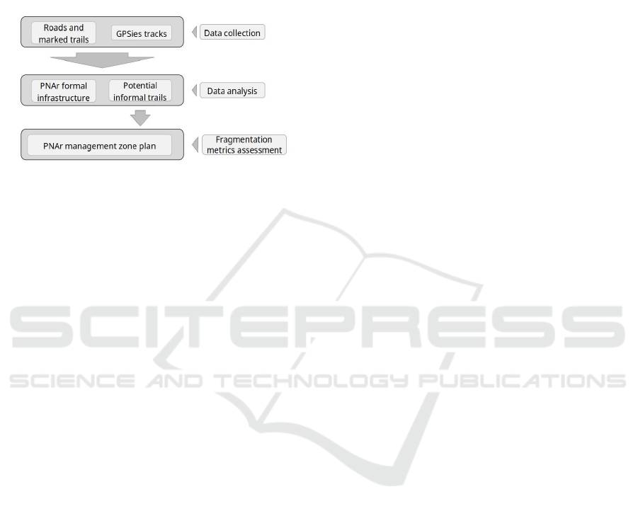
2.2 Methodology
The methodology was structured into three main
phases: data collection from the Wikiloc.com
website; spatial analysis of GPS routes using a GIS;
and assessment of trail-based fragmentation using
spatial metrics (Figure 2).
Figure 2: Schematic representation of the methodological
approach.
2.2.1 Data Collection
In order to characterize the spatial distribution of
visitor-created trails within the PNAr limits, the main
dataset was collected from the Wikiloc website
(Wikiloc, 2021), a crowdsourced online platform
containing GPS routes from visitors who wanted to
share their activities with others. For Europe, Wikiloc
has at the moment one of the best data coverages and
is considered to be suitable for off-trail use
assessment (Campelo and Mendes, 2016; Norman
and Pickering, 2017). The platform has operated since
2006, being one of the first fitness and travel
websites, with more than 28 M tracks (672.000 for
Portugal) and 9 M members by October 2021,
allowing tracking using all kinds of GNSS devices
and smartphones through dedicated applications for
Android and IOS devices.
Search queries on Wikiloc were conducted on
October 2021, using Setúbal, Sesimbra, and Palmela
municipalities as search criteria and considering 30
activities that are using trails for their performance.
Because Wikiloc limits the download to a few .gpx
tracks per user/day, VGI data were downloaded using
web scraping techniques.
In addition to the .gpx file, additional information
associated with the routes was collected, such as
author/user ID, URL of the track, route name/number,
user description, date posted, date recorded, type of
activity, route length, route type (linear or circular),
and downloads received.
2.2.2 Spatial Analysis of GPS Routes
Duplicated tracks and those with evident spatial
errors were eliminated unless the errors could be
fixed. Also, as Wikiloc allows users to draw routes,
these tracks were also excluded as they represent an
intention of use and not an actual recording. The
debugging process allowed create a clean shapefile
with the entire downloaded GPS track using QGIS
3.10 (QGIS), and the park boundary polygon was
used as a feature selection criteria for extracting the
routes that crossed or were within the PANr limits to
be used in the further analyses. One of the advantages
of using QGIS with .gpx files is that it converts
automatically the point data to line features without
the need to run any data management tools.
For extracting the potential informal trail
network, the official PNAr infrastructure (official
public road network and marked trails), including
official roads and trail network was considered as the
formal trail network. Moreover, in order to absorb the
spatial errors of bad GNSS reception under deficient
atmospheric conditions and canopy cover, a 30 m
buffer width of the formal PNAr infrastructure was
created. The considered buffer width followed a
similar procedure applied in the Campelo and Mendes
(2016) study, but as satellite reception is sometimes
reduced due to local characteristics of the area, the
buffer width is a bit higher than the 10 metres
employed by Korpilo et al., 2017 for example.
All tracks were then used and routes that
intersected each PNAr infrastructure were extracted
by selecting those that intersected the buffer
polygons, and those that did not (selection, dissolve,
and erase functions). The result was a shapefile
compiling all GPS tracks from activities that used the
formal roads and trail system and in opposite the
potential informal trails, that will be used in the
subsequent phase. The resulting trail networks were
intersected with the PA zonation plan to summarize
the linear extent of potential informal trails across
different management zones. Additionally, the
potential informal trails were also intersected with the
slope map, according to different landform grade
classes to understand if their development and spatial
disposition are related to this aspect.
2.2.3 Trail-based Fragmentation Assessment
To assess the landscape fragmentation within the
PNAr a method similar to Leung and Louie’s (2008)
and Wimpey and Marion (2011) was adopted. As
such, both networks were considered to analyse the
spatial impacts associated with the development of
GISTAM 2022 - 8th International Conference on Geographical Information Systems Theory, Applications and Management
50
informal trails within the PNAr, and to calculate
different landscape metrics: Number of patches;
Mean Patch Size; Largest Patch Index; Mean
Perimeter: Area Ratio (Table 1). For the analysis, the
complementary and partial management
subcategories were merged into a single one of the
same patch type.
Table 1: Landscape metrics.
Number of Patches
(
NP
)
Description NP equals the number of patches of
the corres
p
ondin
g
p
atch t
yp
e
(
class
)
Units None
Range NP ≥ 1, without limit.
NP = 1 when the landscape contains
only 1 patch of the corresponding
p
atch t
yp
e.
Mean Patch Size
(
MPS
)
Description MPS is the average patch size in a
total class area
Units m²
Ran
g
e NP ≥ 0, without limit
Lar
g
est Patch Index
Description LPI equals the area (m²) of the largest
patch of the corresponding patch type
divided by total landscape area (m²),
multi
p
lied b
y
100.
Units Percenta
g
e
(
%
)
Range 0 < LPI ≤ 100
LPI is close to 0 when the largest
patch of the corresponding patch type
is increasingly small. LPI = 100 when
the entire landscape consists of a
single patch of the corresponding
patch type; meaning, the largest patch
com
p
rises 100% of the landsca
p
e.
Perimete
r
-Area Ratio
Description PAR equals the ratio of the patch
p
erimeter
(
m
)
to area
(
m²
)
.
Units None
Ran
g
e PAR ≥ 0, without limit.
3 RESULTS
3.1 Extent of Use among Formal and
Informal Infrastructure Networks
According to the considered search criteria, the final
dataset downloaded from Wikiloc consisted of 3.923
individual tracks, representing a total accumulated of
28.911,254 km, with 2195 tracks (4.509,545 km)
passing through the limits of the study area. This
dataset was uploaded into the platform between
March 2006 and October 2021 by 224 identified users
that participated with 3.635 tracks of the total dataset
downloaded and the remaining were anonymous.
Regarding the total length of use among each
network, a total of 3.839,414 km were considered
using the PNAr formal infrastructure and the
remaining 669,586 km configured potential informal
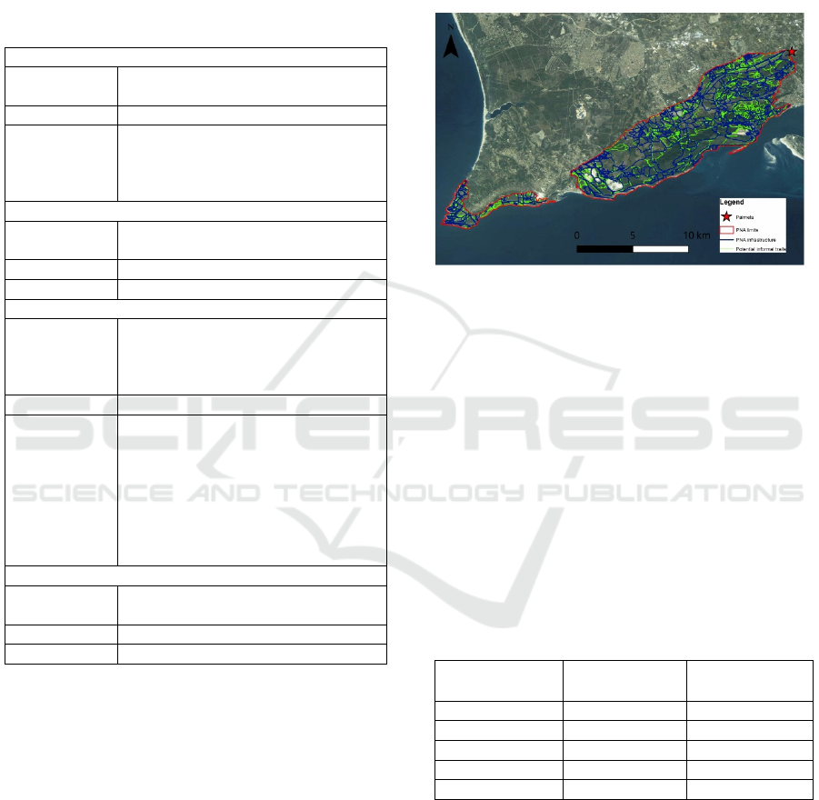
trails (Figure 3).
Figure 3: Spatial distribution of the formal infrastructure
and potential informal trails.
From the routes downloaded from Wikiloc, that
intersected the PNAr, 18% used the informal network
(partially or entirely), and there were 21 routes that
did not intersect a formal trail or road at any point. Of
the 395 routes of users who travelled partially or
entirely out of the formal infrastructure, 97 were
cycling activities, 189 hiking, and 66 running. Only
32 informal trails were used by motorized vehicles
and 11 routes recorded other activities (Table 2). A
reclassification of Wikiloc activities was necessary
following the mobility typology proposed by Callau,
Giné and Perez (2020).
Table 2: Number of GPS tracks posted according to each
type of activity along the formal and informal
infrastructure.
Activity On formal
infrastrcture
On informal
trails
C
y
clin
g
428 97
Hikin
g
977 189
Runnin
g
295 66
Motorize
d
311 32
Others 89 11
When plotting results against the PNAr
management zonation plan, 66% of the potential
informal network was developed on complementary
protection, 27% on partial protection, and the
remaining 7% on full protection (Figure 4). These
results represent all potential management conflicts
between current uses and each management zone.
Assessing Informal Trails Impacts and Fragmentation Effects on Protected Areas using Volunteered Geographic Information
51
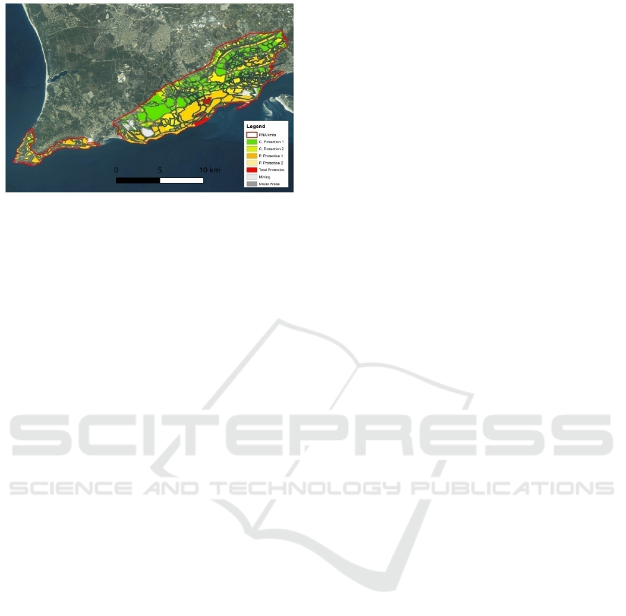
Figure 4: Informal trails accrosss the Arrábida Nature Park
management zones.
3.2 Landscape Fragmentation in
Arrábida Nature Park
Landscape fragmentation metrics indexes were
calculated for both networks and are presented
according to the PNAr management zones. It is
possible to understand the rising in the number of
patches present for all zones between the
fragmentation when considering just the formal
infrastructure and when including the potential
informal trail network (Table 3). The Complementary
P. Zone has the highest number of patches (751), but
it was in the Partial P. Zone that showed the biggest
increase in the number of patches (+427,6%). As for
the Mean Patch Size, there was a decrease in all
management zones between the fragmentation of the
formal infrastructure and when considering also the
informal trails. The Total P. Zone is the management
zone that has the biggest numeric decrease in MPS
(84.006,13 m2), and the Partial P. has the largest
proportionally decrease (-58,65%). When comparing
values of the Largest Patch Index for the formal
infrastructure with results considering all networks,
they increased for the Partial P. and Total P. Zones,
while for the other management zones the Index
decreased. The Mean Perimeter Ratio increased for
all zones, with the biggest proportional (-126,7%)
increasing in the Urban Zone.
4 DISCUSSION
This work presents a methodology for assessing the
impacts of user-created trails and fragmentation
effects in the PNAr using VGI data from a platform
compiling georeferenced tracks from users.
As fitness and travel dedicated web sharing
services become more common, researchers and PA
managers are looking at these VGI components as an
alternative to generate information on the spatial and
temporal patterns of recreational use (Wong, Law and
Li, 2017). One of the main reasons evoked is the
capacity to generate preliminary results, that can
support other types of social studies, without a high
resource demand (Ghermandi and Sinclair, 2019).
The selection of Wikiloc for the assessment
allowed to answer the main goals of the study, and
generated significant data on the recreational use
within the PNAr, more particularly on off-trail use.
This agrees with other studies that obtain their
datasets from online services as a VGI source
(Campelo and Mendes, 2016; Norman et al., 2017).
Also, the number of GPS tracks downloaded (3.635)
can illustrate the popularity of the PNAr within the
Lisbon Metropolitan Area for nature-based tourism
and outdoor sports, with people (224 members/users)
sharing their activity on this platform. Platforms like
GPSies.com and Strava are also popular among
outdoor recreationists and could be an alternative for
this assessment. However, the former online service
was acquired by AllTrails.com, a less popular
platform in Europe, and the Strava dataset is not
easily available to the public.
The results also show that despite most users
preferring the official infrastructure, off-trail use is
still happening, leading to the creation and
proliferation of visitor-created informal trails.
Informal use was most observed close to local cities,
such as Azeitão, Palmela, and Setúbal, and also Cabo
Espichel. The proliferation of informal trails around
cities is many times a consequence of high levels of
use around these core areas, and the lack of an
appropriate formal infrastructure not matching users’
recreational needs and expectations. Off-trail use can
be particularly damaging in the promontory of Cabo
Espichel, as this area contains plant communities that
are sensitive to trampling and erosion impacts.
When compiling the amount of potential informal
trails by management zone to understand the extent
of impact in each zone, the fact that the
complementary protection zone accommodates the
greater linear extent of informal trails goes in line
with the degree of protection normally allowed at this
zone type. Complementary Protection Zones
integrate spaces of more intensive use of the soil,
where the social and economic local development
must be compatible with the natural and landscape
values in place. On the other side, the presence of
informal trails in full protection zone suggests a
potential management conflict as these are areas with
high ecological sensitivity, where recreational use is
GISTAM 2022 - 8th International Conference on Geographical Information Systems Theory, Applications and Management
52

Table 3: Landscape fragmentation indices across the Arrábida Nature Park management zones.
Landscape metrics Mana
g
ement zones
Urban Com
p
lementar
y
P. Partial P. Total P. Overall
Number of patches
PNAr infrastructure 479 388 29 5 901
Informal trails 474 751 153 11 1389
Mean Patch Size
PNAr infrastructure 8.816,60 48.205,55 124.709,85 178.839,40 82.299,47
Informal trails 2.881,53 43.092,12 51.573,67 94.730,27 40.361,32
Largest Patch Index
PNAr infrastructure 0,87 6,55 3,33 0,71 6,55
Informal trails 0,15 6,26 4,67 1,03 6,26
Mean Perimeter Ratio
PNAr infrastructure 0,04 0,02 0,01 0,01 0,01
Informal trails 0,09 0,02 0,02 0,01 0,02
forbidden, representing a management issue for land
managers.
Lastly, the landscape fragmentation assessment
through the use of metrics on the management zone
plan allowed to examine the impacts of informal trails
development at the landscape scale. Just the impact of
roads and formal trails is significant on the MPS, but
when landscape fragmentation was assessed for the
formal infrastructure and potential informal trails
together all indices’ values decrease across zones.
5 CONCLUSION
Despite the COVID-19 pandemic, the demand for the
practice of outdoor recreation activities in protected
areas continues to increase. Since many of these
activities are concentrated on trails, potential impacts
can appear in local environmental and social
conditions leading to a decrease in the quality of the
visitors’ experience.
Nowadays, research regarding informal trails
remains mainly absent, and there is a lack of a clear
and objective methodology to assess the impact of
user-created trails at the landscape level. To answer
these concerns, this study developed a method to
assess the impacts of informal trails in protected areas
using VGI georeferenced tracks stored in online
platforms.
The proposed procedures assessed the lineal
extent of informal trails within the PNAr and the
spatial distribution of user-created trails was
examined through analyses of management zones and
landscape fragmentation indices. These methods have
the advantage to complement other monitoring
studies in place (Mendes et al., 2012) allowing show-
case long-term trends of visitor use, related impacts,
or effectiveness of possible management and
maintenance actions.
The study highlighted different areas prone to be
impacted by off-track use, which represent valuable
information for the managers of that area when
prioritizing management decisions. These areas were
emphasized using the management zonation plan, and
the VGI revealed the extent of informal network
impacts in each park zone. Also, the fragmentation
indices calculated for PNAr produce a significant
coverage of information about the different levels of
impact from informal trails at the landscape scale
using a minimal amount of resources.
This paper is therefore an example that bridges
between a new technological methodology and the
problems protected areas face, opening a discussion
for these domains which can broadly interest
interdisciplinary studies.
ACKNOWLEDGEMENTS
The authors gratefully acknowledge the financial
support of “Fundação para a Ciência e Tecnologia”
(FCT), Portugal, through the MagIC research center
(Centro de Investigação em Gestão de Informação -
UIDB/04152/2020).
Assessing Informal Trails Impacts and Fragmentation Effects on Protected Areas using Volunteered Geographic Information
53

REFERENCES
Arnberger, A. and Brandenburg, C. (2002). Visitor struc-
ture of a heavily used conservation area: The Danube
Floodplains national park, lower Austria. In Arnberger,
A., Brandenburg, C. and Muhar, A. (Eds.) Proceedings
of the 1st international conference on monitoring and
management of visitor flows in recreational and pro-
tected areas (pp. 7-13).
Atzori, R. (2020). Destination stakeholders’ perceptions of
overtourism impacts, causes, and responses: The case
of Big Sur, California. Journal of Destination Market-
ing and Management, 17, 100440. 10.1016/j.jdm
m.2020.100440.
de Bie, K. and Rose, M. (2021). Community usage, aware-
ness and perceptionsVictoria, Australia. In Aas, Ø.,
Breiby, M., Selvaag, S., Eriksson, P. and Børrestad, B.
(Eds.) Proceedings of the 10st international conference
on monitoring and management of visitor flows in rec-
reational and protected areas (pp. 178-179).
Burke, J.A., Estrin, D., Hansen, M., Parker, A., Rama-
nathan, N., Reddy, S. and Srivastava, M.B. (2006). Par-
ticipatory sensing. Center for embedded network sens-
ing. Center for Embedded Network Sensing: UCLA.
Retrieved from: http://escholarship.org/uc/item
/19h777qd.
Callau, A., Perez, Y. and Giné, D. (2020). Quality of GNSS
Traces from VGI: A Data Cleaning Method Based on
Activity Type and User Experience. ISPRS Interna-
tional Journal of Geo-Information. 9. 727.
10.3390/ijgi9120727.
Chua, A., Servillo, L., Marcheggiani, E. and Moere, A.
(2016). Mapping Cilento: Using geotagged social me-
dia data to characterize tourist flows in southern Italy.
Tourism Management, 57, 295-310.
Campelo, M. B. and Mendes, R.M.N. (2016). Comparing
webshare services to assess mountain bike use in pro-
tected areas. Journal of Outdoor Recreation and Tour-
ism, 15, 82-88.
Dickinson, J.E., Hibbert, J.F. and Filimonau, V. (2016).
Mobile technology and the tourist experience:
(Dis)connection at the campsite. Tourism Management,
57, 193-201.
Ghermandi, A., and Sinclair, M. (2019). Passive
crowdsourcing of social media data in environmental
research: A systematic review. Global Environmental
Change, 55, 36–47.
Goodchild, M.F. (2007). Citizens as sensors: The world of
volunteered geography. GeoJournal, 69(4), 211-221.
Heikinheimo, V., Minin, E.D., Tenkanen, H., Hausmann,
A., Erkkonen, J. and Toivonen, T. (2017). User-
generated geographic information for visitor
monitoring in a national park: A comparison of social
media data and visitor survey. ISPRS International
Journal of Geo-Information, 6(3), 85.
Jackson, S., Stevenson, K., Larson, L., Peterson. M. and
Seekamp, E. (2021). Outdoor activity participation
improves adolescents’ mental health and well-being
during the COVID-19 pandemic. Int J Environ Res
Public Health, 18(5):2506.
Korpilo, S., Virtanen, T. and Lehvävirta, S. (2017).
Smartphone GPS tracking-inexpensive and efficient
data collection on recreational movement. Landscape
and Urban Planning, 157, 608-617.
Leung, Y.F. and Marion, J.L. (2000). Recreation Impacts
and Management in Wilderness: A state-of-knowledge
review. In: Cole, D.N., McCool, S.F., Freimund, W. A.,
Borrie, W. T. and O'Loughlin, J. Wilderness science in
a time of change conference. Missoula, MT. 23-27 May
1999, Proceedings RMRS-P-15-VOL-5. Vol. 5:
Wilderness ecosystems, threats, and management.
USDA Forest Service, Rocky Mountain Research
Station, Ogden, UT, USA.
Leung, Y.-F. and Marion, J.L. (1999). Spatial strategies for
managing visitor impacts in National Parks. Journal of
Park and Recreation Administration. 17(4): 20-38.
Leung, Y.F. and Louie, J. (2008). Visitor Experience and
Resource Protection Data Analysis Protocol: Social
Trails. North Carolina State University, Raleigh, NC, p.
17.
Levin, N., Lechner, A. M. and Brown, G. (2017). An
evaluation of crowdsourced information for assessing
the visitation and perceived importance of protected
areas. Applied Geography, 79, 115-126.
Marion, J.L. and Leung, Y.F. (2001). Trail resource impacts
and an examination of alternative assessment
techniques. Journal of Park and Recreation
Administration (Special Issue on Parks and
Greenways) 19.
Marion, J.L. and Leung, Y.-F. (2004). Environmentally
sustainable trail management. In: Buckley, R. (Ed.),
Environmental Impact of Tourism. CABI Publishing,
Cambridge, MA.
Mendes, R.N., Silva, A., Grilo, C., Rosalino, L., and Silva,
C. (2012). MTB monitoring in Arrábida Natural Park,
Portugal. In Fredman, P., et al. (Eds.) Proceedings of
the 6th international conference on monitoring and
management of visitors in recreational and protected
areas (pp. 32-33).
Muhar, A., Arnberger, A. and Brandenburg, C. (2002).
Methods for visitor monitoring in recreational and
protected areas: An overview. In Arnberger, A.,
Brandenburg, C. and Muhar, A. (Eds.) Proceedings of
the 1st international conference on monitoring and
management of visitor flows in recreational and
protected areas (pp. 1-6).
Norman, P., and Pickering, C.M. (2017). Using volunteered
geographic information to assess park visitation:
Comparing three on-line platforms. Applied
Geography, 89, 163-172.
Orsi, F., and Geneletti, D. (2013). Using geotagged
photographs and GIS analysis to estimate visitor flows
in natural areas. Journal for Nature Conservation, 21,
359-368.
Sessions, C., Wood, S.A., Rabotyagov, S., and Fisher, D.M.
(2016). Measuring recreational visitation at U.S.
National Parks with crowd-sourced photographs.
Journal of Environmental Management, 183, 703-711.
Volenec, Z., Abraham, J., Becker, A. and Dobson, A.
(2021). Public parks and the pandemic: How park usage
GISTAM 2022 - 8th International Conference on Geographical Information Systems Theory, Applications and Management
54

has been affected by COVID-19 policies. PLoS ONE,
16(5): e0251799.
Walden-Schreiner, C., Leung, Y.-F., Newburger, T. and
Woiderski, B. (2012). Developing an accessible meth-
odology for monitoring visitor use patterns in open
landscapes of Yosemite National Park. Park Science,
29(1), 53-61.
Walden-Schreiner, C., Rossi, S.D., Barros, A., Pickering,
C. and Leung, Y. F. (2018b). Using crowd-sourced pho-
tos to assess seasonal patterns of visitor use in mountain
protected areas. Ambio, 47, 781-793.
Wang, D., Xiang, Z. and Fesenmaier, D.R. (2014). Adapt-
ing to the mobile world: A model of smartphone use.
Annals of Tourism Research, 48,11-26.
Wikiloc (2020). Wikiloc outdoor navigation. viewed Octo-
ber 2021, Retrieved from: https://www.wikiloc.com/
Wimpey, J. and Marion, J.L. (2010). The influence of use,
environmental and managerial factors on the width of
recreational trails. Journal of Environmental Manage-
ment, 91, 2028-2037.
Wimpey, J., Marion, J.L. (2011). A spatial exploration of
informal trail networks within Great Falls Park, Journal
of Environmental Management. VA. 92, 1012–1022.
Wong, E., Law, R. and Li, G. (2017). Reviewing geotagging
research in tourism. Proceedings of the International
Conference Information and Communication Technolo-
gies in Tourism, 2017, 43–58.
Wood, S.A., Guerry, A.D., Silver, J.M. and Lacayo, M.
(2013). Using social media to quantify nature-based
tourism and recreation. Scientific Reports, 3. 2976.
10.1038/srep02976.
Assessing Informal Trails Impacts and Fragmentation Effects on Protected Areas using Volunteered Geographic Information
55
