
Exploring Geolocation Data: An Inquiry-based Methodology Used in
Lower Secondary Education
Gabriela Lovászová
a
and Viera Michaličková
b
Department of Informatics, Constantine the Philosopher University in Nitra, Tr. A. Hlinku 1, Nitra, Slovakia
Keywords: Inquiry-based Learning, Mobile Technology, Computer Science Education, Geolocation Data.
Abstract: The presented research study is focused on building conceptual knowledge of pupils in the field of data
representation and tools for their processing using the inquiry-based methodology (the 5E model was applied).
We have chosen geolocation data as a less traditional type of data, which also provides an opportunity for
a non-traditional form of teaching computer science outdoors using mobile technology. Pupils’ task is to
determine suitable tools for processing geolocation data. They analyze a GPX file’s contents and formulate
questions that can be answered from the available data. During the outdoor phase of the learning scenario,
pupils produce an original GPS drawing and share it in a common digital map. Data collected from teachers
who implemented the proposed methodology in several primary schools confirmed that our methodology
based on the IBL principles was successful in achieving educational goals at higher levels of Bloom’s
taxonomy. The teachers were also confirming that combining the inquiry approach with using mobile
technology stimulates pupils' interest in the subject of teaching significantly.
1 INTRODUCTION
Typically, computer science is taught in a computer
laboratory where the individual work of pupils
prevail. Pupils process data they are creating
themselves (texts, images), have been given by
a teacher or downloaded from the internet.
Sometimes, data are generated by a program or pupils
get it using a specific hardware (e. g. scanner, camera,
microphone or some other sensor). When processing
data of a certain type, pupils usually work with
a specific software tool and solve tasks given by their
teachers. If software is new (unknown) to pupils, they
work according to their teacher’s instructions.
In this paper, we focus on solving the problem of
building conceptual knowledge of pupils in the field
of data representation and tools for their processing at
higher levels of Bloom's taxonomy (BT) using
the inquiry-based (IB) methodology. Conceptual
knowledge is one of the 4 categories of the revised
Bloom's taxonomy knowledge dimension and
comprises the interrelationships among the basic
elements within a larger structure that enable them to
function together. The 3 other categories include the
a
https://orcid.org/0000-0001-6972-5139
b
https://orcid.org/0000-0002-8036-5792
factual, procedural, and metacognitive knowledge
(Krathwohl, 2002). We have chosen geolocation data
as a less traditional type of data, which also provides
an opportunity for a non-traditional form of teaching
computer science outdoors using mobile technology.
The well-designed inquiry-based learning (IBL)
enhances learners' curiosity and motivation, mediates
deeper understanding, and fosters critical thinking.
Through IBL activities, pupils are taught to think and
act like the scientists do. The meta-analysis of many
empirical studies presented in (Lazonder and
Harmsen, 2016) points out that whenever learners act
like scientists, their teacher should provide them with
adequate guidance. The authors of the meta-analysis
found out, that the learners who were given some kind
of guidance acted more skillfully during the task,
were more successful in obtaining relevant
information from their investigational practices and
scored higher on final tests. As we agree on the
beneficial implications of the constructivist learning
and teaching strategies, we have decided to apply the
5E instructional model of IBL (Bybee et al., 2006) in
our methodology.
Lovászová, G. and Michali
ˇ
cková, V.
Exploring Geolocation Data: An Inquiry-based Methodology Used in Lower Secondary Education.
DOI: 10.5220/0011036300003182
In Proceedings of the 14th International Conference on Computer Supported Education (CSEDU 2022) - Volume 2, pages 351-360
ISBN: 978-989-758-562-3; ISSN: 2184-5026
Copyright
c
2022 by SCITEPRESS – Science and Technology Publications, Lda. All rights reserved
351

Tkáčová, Šnajder and Guniš (2019) pursued
a research study on teachers’ perception, attitudes,
experiences, misconceptions, and barriers to IB
teaching of computer science. Though the IB
approach is still considered rather innovative in
Slovak schools, this study confirmed that many
computer science teachers in primary and secondary
schools are willing to apply IBL principles in their
teaching. The teachers seek for additional training
and prefer using ready-made methodologies to
overcome their lack of experience. They found the
IBL appropriate mainly for topics concerned with
programming or data processing.
One project of teaching the basics of
programming in Scratch enriched by IBL elements
was described in (Vaníček, 2015). The author also
suggests that IBL is a response to the improper
teaching methods used in primary and secondary
schools that are often based on mere reproduction of
knowledge, on instruction and tutorials not resulting
in deeper comprehension nor development of
thinking skills.
Since mobile devices have become available in
schools, many educational researchers are focusing
on finding effective ways of using them in the
curriculum. Lovászová, Cápay and Michaličková
(2016) presented the best practices for using mobile
technology in teaching computer science. The main
reasons for considering mobile learning scenarios
more frequently include:
• they can facilitate collaborative learning,
creative projects and authentic learning
activities not bound to the indoor classroom
environment,
• they have potential to contribute to the
intrinsic motivation of pupils (because of
their personal features),
• they can facilitate both, the active
construction of knowledge and development
of new skills.
Besides using mobile devices as a versatile
learning tool or to enhance the interactivity and the
collaborative aspect of computer science lessons,
pupils can also program their own mobile
applications as well as take the mobile devices
outdoors to experience location-based games or
collect some specific data necessary for a project.
Yakar et al. (2020) explain how mobile
technology is being adopted in learning nowadays
and how it helps learners and educators with the key
aspects of constructivism such as interaction,
collaboration, and authentic experience. These create
an informal atmosphere where social and cognitive
constructivism can be implemented more easily to
enhance the quality of formal lessons.
In (Suárez et al., 2018), a systematic review of
using mobile technology in IBL was conducted. The
study aimed at examining to what extent the use of
mobile technology for IBL supports and limits
learners' agency. The authors developed an analytical
framework helpful for designing effective mobile
activities that balance learners’ agency with mobile
technology. Their classification includes 12 types of
mobile activities derived from the direct instruction,
access to content, data collection, peer-to-peer
interaction and contextual support type of mobile
activities. Furthermore, they identified 6 dimensions
for learners' agency (control over goals, over content,
over actions, over strategies, and options for
reflection and monitoring). The way the mobile
technology is integrated within the proposed IB
methodology corresponds with their
recommendations. In our methodology, pupils are
given an opportunity to explore geolocation data in
a computer laboratory using multiple software tools
first. But subsequently, pupils are involved into
a collaborative data-collection activity based on using
tablets or smartphones. Pupils are free to set their own
goal (come up with an original idea for a GPS
drawing) and plan the procedure of achieving it.
Throughout the outdoor phase as well as after
visualizing the collected data (the GPS drawings),
pupils are able to reflect their results or refine their
strategy for solving the problem if necessary.
2 EXPLORING GEOLOCATION
DATA WITH PUPILS
At the heart of inquiry-centered learning is the inquiry
question. Thinking is driven by questions, not
answers. If pupils are engaged in inquiry, they are
expected to construct their own meaningful questions,
refine, and improve their questions, strategize on
designing and producing responses to their questions
(Chu et al., 2021). In our methodology, pupils’ task is
to determine suitable tools for processing geolocation
data. They analyze a GPX file’s contents and
formulate questions that can be answered from the
available data.
After learning about GPX files and their
processing using a digital map, pupils are asked to use
their GPS-enabled mobile devices to record
geolocation data while moving outdoors actively.
They are encouraged to express their creativity to
produce original GPS drawings.
CSEDU 2022 - 14th International Conference on Computer Supported Education
352
Finally, pupils present their GPS drawings in
a shared map, creating one common product because
of collaborative work of the whole group.
2.1 Design of the Inquiry-based
Methodology
The suggested methodology is meant for pupils in 7
th
or 8
th
grade (in Slovakia these are 12-14 years old
pupils). It directly follows a preceding one that is
focused on principles of satellite navigation. We
assume that pupils are already familiar with concept
of geographical coordinates, and they have used their
mobile devices to navigate to multiple places
recently.
The learning activities are planned for a period of
90 minutes (2 lessons). Pupils work in pairs to
promote collaboration and communication while
solving problems. Worksheets are used as an aid for
structuring pupils’ ideas.
To process the recorded routes, teachers have to
prepare a shared digital map with layers for each pair
of pupils. Sample GPX files with geolocation data are
attached to this methodology too. They are selected
on purpose to demonstrate different types of routes.
Teachers can also prepare their own files, e. g. from
around the school area. However, routes must be
recorded in the field and exported to GPX files, not
edited using a map software.
In following subsections, key information about
each of the 5 consecutive phases of the 5E model is
summarized.
2.1.1 Engaging
At the very beginning, the main goal is to generate
interest of the topic, drawing on prior knowledge and
experience of pupils. Teacher raises these questions:
• What types of files do you know?
• What information these files contain?
• What software would you use to view and
process them?
The answers of pupils are written on a board into
a 3-column table (Table 1). Pupils use their
worksheets to record all the acceptable answers.
Alternatively, two lists of file types and applications
could be made by pupils. File types are then assigned
to applications that are applicable for viewing or
processing them.
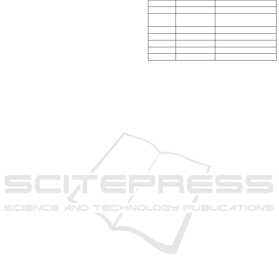
Table 1: Example of the first activity’s solution.
file t
yp
e contents a
pp
lication
jpg
p
icture Paint
sb3 programming
p
roject
Scratch
docx text document MS Wor
d
xlsx table MS Excel
pp
tx
p
resentation MS PowerPoint
html web page Google Chrome
wav soun
d
Windows Media Playe
r
2.1.2 Exploring
The lesson continues by posing a problem. Each pair
of pupils gets a different GPX file to explore. Teacher
acts as a facilitator observing pupils’ interactions and
asks the following inquiry-oriented questions:
• What software can we use for viewing the
contents of GPX files?
• What kind of data are saved in GPX files?
• What questions can be answered from
analyzing these data?
During the previous activity, pupils have recalled
their knowledge of various information types, their
digital representations as well as tools for their
processing. They have realized that different file
types are processed by different applications and
applications can manage to process or view the
contents of various file types. Therefore, when
examining a GPX file, they may experiment with
opening it in multiple different applications to
discover the most appropriate one. The expected
findings include:
• A GPX file is a text file.
• It can be opened in a text editor, e. g.
Notepad, MS Word, in a web browser, e. g.
Mozilla Firefox, Google Chrome, in
a spreadsheet editor, e. g. MS Excel (in this
case, data need to be converted).
After viewing the file, pupils analyze its content
putting down notes in their worksheets. They should
be able to identify the time and geographical
coordinates (latitude, longitude), with which they
have experience from previous lessons. The file also
contains elevation data. The numeric data is tagged.
Pupils should recognize their meaning (TIME = time,
LAT = latitude, LON = longitude, ELE = elevation,
TRKPT = track point) either from their English
knowledge or the numerical values themselves. They
should also note the repetitive structure of data and
hypothesize that it is a record of geographical places
in a time sequence (times increase), possibly a record
of one’s movement while walking or running.
Exploring Geolocation Data: An Inquiry-based Methodology Used in Lower Secondary Education
353
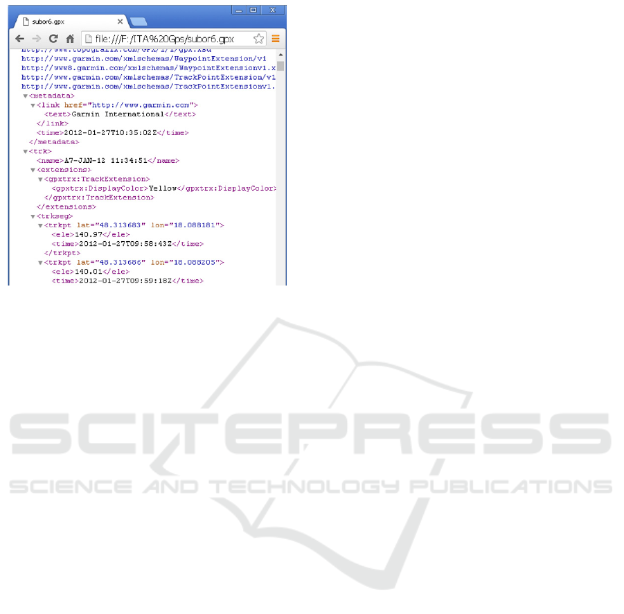
Figure 1: Using a web browser for viewing contents of
a GPX file.
Next, teacher asks pupils to formulate questions
that can be answered from data contained in their
GPX file. Discussion should result in a list of relevant
questions, e. g.:
• Where is the route located?
• When was the route recorded?
•
What is the length of the route?
• How long did the recording last?
• What was the maximum, minimum altitude,
what about the altitude difference?
• What was the speed of movement?
2.1.3 Explaining
Guided by teacher, pupils try to explain their
observations and findings in their own words.
Teacher is responsible for connecting pupils’
informal language with formulations based on using
the proper terminology.
Next, pupils have to suggest the way of obtaining
necessary information form data. Some numerical
data could be processed using a spreadsheet editor
(e. g. to calculate the record’s duration or determine
the minimum and maximum altitudes). However, we
need a digital map to process geographic coordinates.
In this phase, the learning activity is focused on
processing data files using the Google Maps
application. Pupils need to find out their route’s
location and give it a concise title. Teacher provides
pupils with link to a shared map comprising dedicated
layers to use. Pupils import their file into their
individual layer. Task of renaming a route according
to its location and nature develops critical thinking –
the ability to interpret data. In every case, the route’s
description also includes basic statistics necessary for
answering questions stated during the previous phase.
Pupils can complete descriptions of their routes by
adding some explaining text or even an image.
Then, pupils present their solutions to each other
in a shared map. They will get examples of different
types of routes, e. g.:
• long hikes in nature with a large elevation
difference,
• shorter routes mapping objects in the urban
environment,
• routes creating a meaningful image in
a structured urban environment,
• routes on free space representing
inscriptions etc.
Teacher encourages pupils to discuss the use of
GPS tracking in everyday life, e. g.:
• for recording sports performances (tourists,
runners, cyclists),
• to record routes traveled by car (business
trips, holidays),
• for map creation purposes (hiking trails,
roads, land properties),
• for creating interesting images, works of art
(graphics, advertisements).
2.1.4 Extending/Elaborating
After working with GPX files and using a shared
Google map, we continue with the outdoor part of the
methodology. Pupils should apply the acquired
knowledge of GPX files and digital map skills to their
own data in a mini project: They will design their own
image, which they will record outside using a mobile
device with GPS and publish it in a shared digital
map. They still work in pairs. Each pair of pupils has
a tablet or a smartphone with Locus Map Free
application installed (or some other application
providing similar functionalities depending on the
targeted mobile platform).
The outdoor part of the route recording activity
should take approximately 25-30 minutes. A school
playground is usually a satisfactory (as for its size)
and safe drawing space. To get nice, aesthetic results,
we recommend pupils drawing simple, single-stroke
line images (e. g. geometric shapes and their
combinations), outlines of buildings or large
inscriptions (written font is more suitable than printed
one).
After returning to school, pupils can view results
of their work first on a mobile device. Then, they
transfer the GPX file they have just produced to a
CSEDU 2022 - 14th International Conference on Computer Supported Education
354
computer, either wirelessly or by cable. The final task
is to import their GPX file into a common map, giving
their drawing a proper name.
2.1.5 Evaluating
At the end, pupils evaluate each other's drawings
voting for the most beautiful picture (originality and
aesthetics are considered). The teacher can also
project some additional examples of GPS drawings
made by professional GPS artists or other groups of
pupils. The experience of being involved in the GPS
drawing activity is reflected by pupils and all the
acquired knowledge is summarized. Pupils fill in the
self-assessment cards included in their worksheets.
This helps them with reviewing the contents of
lessons as well as systematizing of the curriculum.
3 RESEARCH STUDY
The proposed methodology was developed within the
national project IT Academy which was aimed at
designing and implementing innovations into the
science and technical education with special focus on
teaching computer science to foster pupils’
motivation for pursuing career in IT sector. The
methodology was implemented by teachers from
several Slovak schools. In our research study, two
research questions (RQ) were posed:
RQ1: What is the knowledge level of lower
secondary pupils as for the field of data
representation and tools for their processing?
RQ2: How is the proposed methodology
beneficial for developing the conceptual knowledge
at higher levels of BT?
3.1 Methods
The research involved 30 teachers from 30 Slovak
primary schools. They applied the methodology in the
7th or 8th grade classes once or repeatedly with
different pupils in the school years 2018/2019 and
2019/2020. We provided teachers with detailed
lesson plans, supplementary methodical and technical
instructions, worksheets, and data files. After the first
year of verification, we conducted interventions
based on feedback from teachers. Some minor
changes in learning materials for pupils were made
(re-formulating of the assignments and updating
manual of the recommended mobile application). The
methodical instructions for teachers were extended to
explain some issues identified from the feedback data
(some instructions or tasks for pupils were
misunderstood by teachers). Also, a list of
documented pupils’ misconceptions was added.
For research purposes, teachers provided us with
data of two types:
1. Their pupils’ products - completed worksheets
as well as geolocation data pupils recorded with
mobile devices and subsequently processed in Google
Maps.
2. Written structured reflections, in which
teachers commented on goals of the learning
activities, the extent to which they were met, the
content’s complexity, the teaching forms, methods,
tools and didactic technologies applied.
We analysed the obtained data qualitatively.
Pupils’ solutions in worksheets were evaluated and
categorized to identify the level of knowledge, most
common mistakes, and misconceptions. Teachers'
reflections were also analysed in depth to better
understand the context in which pupils were working
while solving problems. We were interested in
abstracting teachers’ essential views on the proposed
methodology as for its key attributes (IBL principles,
learning outdoors, using mobile technology).
3.2 Results
The results of data analysis from worksheets are
presented according to solutions of tasks in the
individual phases of IBL:
Task 1 (Engaging): Name various types of files.
What kind of information do they contain? What
application do we need to view and process them?
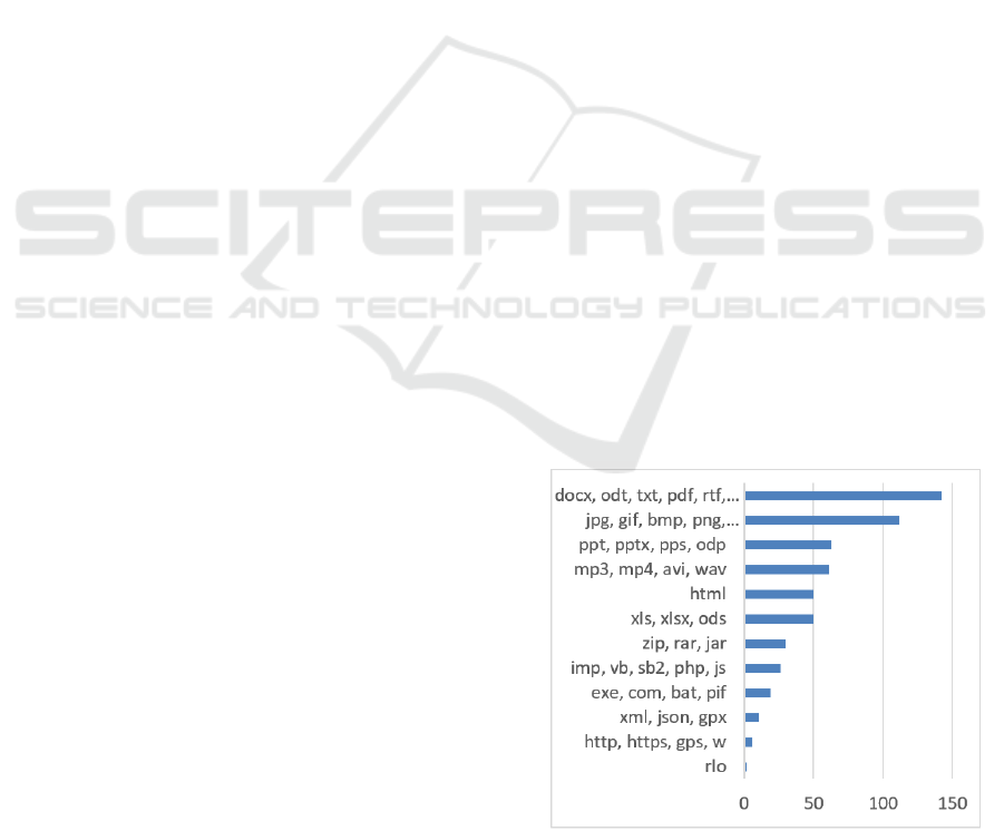
There were 41 different answers found in
worksheets that we have categorized in 12 categories.
In Figure 2, the frequencies of responses are
visualized.
Figure 2: The frequencies of file types stated by pupils.
Exploring Geolocation Data: An Inquiry-based Methodology Used in Lower Secondary Education
355

Most often, pupils mentioned the files containing
text, image or a computer presentation, audio/video,
tables, compressed files, programming codes,
executable or some other system data files, structured
data, special files having an educational content as
well as various incorrect answers (http, https, gps, w).
In most of the answers (80%), the information
kind and the related applications were identified
correctly. Though, also some mistakes were noticed:
• Pupils did not distinguish between the
contents of a file and the tool for processing
it. They stated e.g., that the file “xls” contains
“spreadsheet” and the processing tool is
“Excel”, “doc” contains “text editor” and is
processed by “OpenOffice.org”.
• Pupils stated http, https (mistaken with html)
as the file type.
• Pupils identified applications with company
names: Adobe (instead of Adobe Reader),
Google (instead of Google Chrome),
Microsoft (instead of MS Word).
• Pupils confused operating system and
applications: they presented Android,
Windows, iOS, Linux as applications for
word processing or websites.
Most teachers found the difficulty of this task
appropriate to prior knowledge of pupils (“In 7th
grade, pupils have already experience with various
data files.“). However, for some teachers, the activity
was difficult, because “pupils do not know lots of
files and are not capable of naming it properly”.
According to many teachers, pupils did not
understand the assignment at first. But after giving
a specific example (e. g. a text file having the txt
extension contains text data and a text editor, such as
Notepad, is applicable for viewing it), they were
ready to respond on their own (“First, pupils were
a bit confused, but after a short reminding, they
continued further without major problems.”).
Task 2 (Exploring): Find out the following: What
software do we need for viewing data in GPX files?
What data are contained in GPS files? What
information can we get from the data?
The purpose of this task was to find out what data
the unknown file type contains. To do this, pupils
should first find out what application they can use to
view the contents of the file. In their worksheets,
pupils gave more options. They suggested a text
editor, a spreadsheet processor, a web browser, even
some map software was mentioned (Google Earth,
Google Maps, MapSource, OpenStreet Maps). The
incorrect answers comprised applications that are not
applicable for viewing GPX files at all, e. g. a graphic
editor (Paint) or pupils stated something other than an
application (e. g. GPS, XML).
The second part of the task was focused on higher
cognitive processes: to analyse the text and abstract
essential data (time, latitude, longitude, altitude),
recognize the pattern in the data structure (route as
a sequence of points on Earth arranged in time), and
formulate problems (questions) which can be solved
using the data in the file.
The complexity of the task depended on
application pupils were trying to use for viewing the
GPX file’s contents. In a simple text editor, the text is
not structured so the task is more difficult. More
sophisticated editors do hide markup language tags
that describe the meaning of the data. The most
obvious is the display in a web browser – structured
with visible tags. In the unstructured view of the file,
pupils noticed an irrelevant link to the page of the
application that recorded the route, and “this
distracted them from the essentials, and they didn't
have enough time to examine their GPX file well.”
In the last part of the task, pupils formulated many
good questions: “Where does the route start? Where
does it end? In which state / city is the route? How
long did it take? What was the average speed? What
was the lowest and highest altitude? What is the
overall ascent/descent? What color will the route be
marked?” The most common mistakes of pupils were:
• Pupils reported that their file contained data
that was not in it. It was primarily the
information that could be calculated from the
data in the file (average speed, duration, route
length, ascent, descent, graphs). But also,
such data were mentioned that are not present
in the file at all nor they can be calculated
from the available data (map, heart rate).
• Pupils also asked questions confirming that
they did not realize the fact, the route saved
in their GPX file had been traveled and
recorded in the past (“Where am I? Where to
go? When will the route take place? How
long will my route take? How fast will
I move?”).
• Pupils gave vague or ambiguous wording of
their questions (“How high are we? What are
the coordinates?”)
Next, pupils were processing the GPX file using
a map software to answer questions formulated
before:
Task 3 (Explaining): View the route saved in your
GPX file in Google Maps. Find out where the route is
situated and name it appropriately. Study the route’s
CSEDU 2022 - 14th International Conference on Computer Supported Education
356
statistics in its description. Complete the description
with appropriate text and images.
Some solutions contained a transcript of the route
data as calculated by the map software not
corresponding to questions formulated by pupils in
previous task. The rest of pupils tried to formulate
answers to their own questions. In case of ambiguous
questions, the answers were either missing or
clarifying the question (“Altitude? - at the beginning
138 m, at the end 134 m”).
Approximately half of the pupils did not name
their route, or they gave it a neutral title, the one of
their work files (e. g. “file1”). This task was focused
on the ability to capture the essence of the file’s
contents and verbalize it concisely. For pupils, it was
either difficult or they did not consider it important.
Even teachers did not pay attention to this in their
comments.
In the phase of extending/elaborating, pupils
recorded routes using mobile devices and after
returning indoors, they visualized it in a map
software. The results varied as for their complexity –
from simple random doodles a few meters long to
routes having several kilometres representing
meaningful pictures.
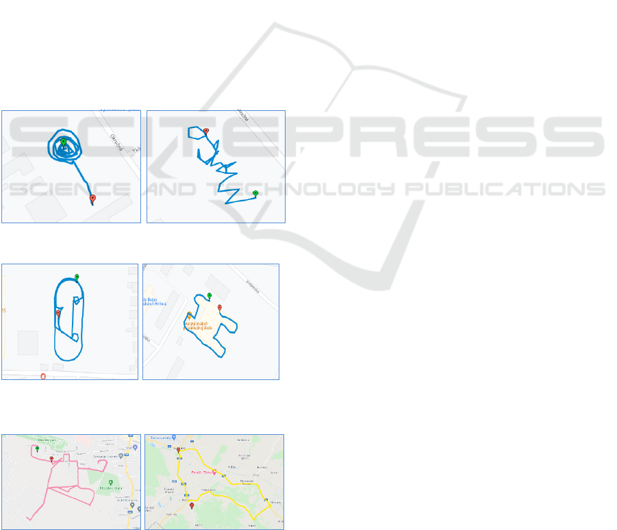
Figure 3: Drawings on free space (Rose, MANGO).
Figure 4: Drawings aligned to objects (Athletic smiley,
Letter H).
Figure 5: Drawing along the roads (Figure, Seal).
Most of the drawings were recorded on larger
open areas around the school (Figure 3) or were
copying the outlines of objects situated around the
school, e. g. buildings, fences, playgrounds
(Figure 4). Longer routes were made along the roads
and pupils recorded them while cycling (Figure 5).
Teachers reported problems with procedural
knowledge in relation with this part of the teaching:
“Pupils did not know how to use the mobile
application well, they also had difficulty transferring
files.” “Surprisingly, many pupils have encountered
the need for downloading data from mobile phones to
computers for the first time.” “The map creation
(routes in Google Maps) has not yet been automated
enough.” There were also problems with bad weather
and bad GPS signals.
Teachers assessed the involvement of pupils
mostly positively: “Pupils were so focused on work
and started enjoying it, so it was a problem to get them
off the field.” “Pupils expected creating nicer
pictures, but the topic was appealing to them, and
some of them even tried the application later – outside
of class.” “Students like to work with mobile devices
and applications.”
In the final evaluating phase, pupils were asked to
fill in a self-assessment section in their worksheets.
They were indicating the achievement of objectives
by approving provided statements:
• I can name at least 3 types of files and
applications for their processing.
• I can name at least 3 types of data that a GPX
file contains.
• I can view the contents of a GPX file in
Google Maps.
• I can find out the length of the route, duration,
average speed, ascent, descent from the data
in the GPX file.
• I can record a route using tablet or
smartphone with GPS and the My Tracks or
Locus Map Free app.
• I can transfer a GPX file from a mobile device
to a computer.
Most pupils indicated that all goals had been met.
However, there were also answers in which the pupils
admitted that they had not acquired some knowledge
or skills. Most often, they could not name the file
types and applications to process them. They also
stated problems with recognizing the meaning of data
in GPX files. In the second part of the activity, some
pupils admitted that they had not learned to use
a mobile device to record a route and transfer a file
from the mobile device to a computer.
Exploring Geolocation Data: An Inquiry-based Methodology Used in Lower Secondary Education
357

The pupils' problems they indicated in the self-
assessment rubric matched the problems reported by
teachers. From their point of view, the least
problematic was the using of digital map (pupils
could view the routes and reading the statistics).
Teachers mentioned only some technical issues
related to signing into the Google accounts.
3.3 Discussion
RQ1: What is the knowledge level of lower secondary
pupils as for the field of data representation and tools
for their processing?
The results of the analysis of pupils' products
(completed worksheets, recorded routes) give us
a picture of their knowledge level. Numbers of
responses in individual categories depicted in
Figure 2 correspond to the experience of pupils in the
7th or 8th grade – they have the most experience with
text documents, followed by pictures, computer
presentations, multimedia, and tables. In these
categories, pupils usually did formulate the correct
answers using the appropriate terminology, which
indicates knowledge at high levels of BT – they know
the specific data files, understand that a file is a set of
data of some kind, know data files of different types
as well as the applications suitable for their
processing. Their knowledge is not formal, it is based
on experience from lessons.
We expected a larger share of answers in the
category of program code files, given that the topic of
programming makes up about a fifth of the computer
science curriculum in Slovakia. We explain this by
saying that if pupils use an online environment for
programming (e. g. Scratch), projects are
automatically saved in the cloud, so pupils have no
explicit experience of saving them to files.
Responses in other categories mostly represented
knowledge gained through informal learning. In these
responses, we noted more frequent cases of
misconceptions and uncertainty in terminology. We
rate these answers as naive without deeper
understanding. The only exceptions were HTML
files, which pupils usually named correctly (age-
appropriate), even though this is not the content of the
formal lower secondary computer science education.
In classes with problems reported, the teachers
pointed out, that “pupils know how to work with files
(delete, move from folder to folder), but to define
what a file is, they have a problem with that”. Thus,
they have procedural knowledge of working with
files, but lack a deeper conceptual knowledge of files
and data types.
The proposed methodology gave us a good
opportunity to explore pupils' higher levels of
knowledge and cognitive skills (file data analysis,
abstraction of essential data from the file, data
structure recognition) as well as the generic skills
(critical thinking, question and answer formulation,
technical skills, and creativity).
From the analysis of pupils' responses and
feedback from teachers, we conclude that the task was
appropriate to the age and abilities of the targeted
group. In other words, the pupils can achieve a level
of knowledge about data representations and tools for
their processing at higher levels of abstraction.
For example, some teachers reported that pupils
“were able to analyse the contents of GPX files with
ease and used suitable application to obtain
information from data in the GPX file”, “managed to
work with files, found an application that opens
a GPX file and independently evaluated provided
data”. As part of this activity, pupils gained their own
experience in interpreting structured data expressed
in a markup language that is readable by both the
computer and the human being.
According to the results of the data analysis, the
most challenging task for pupils was to formulate
questions (“It was problematic to formulate questions
that can be answered using data from the GPX file.”).
One teacher explained his evaluation like this:
“Finding the answers, which we can find out from the
available files, was initially embarrassing – pupils
expected "ready-made" information.” The teacher's
comment is rather optimistic as the attitude of pupils
had been changed and was caused by the lack of
experience with the IBL method.
Mistakes in the wording of questions revealed
misunderstandings of the concept of one's motion
path recording, but also a lack of generic skill to
clearly formulate the problem.
When working with mobile devices, we found that
although pupils use tablets and smartphones in their
personal lives, their technical skills are limited to
working with selected applications. Capturing and
recording data to a file and transferring them from
a mobile device to a computer for further processing
was a new experience, which contributed to the
development of their technical skills in working with
mobile devices. Some pupils discovered new features
of the mobile route recording application
independently (“They changed color and thickness of
the route being drawn.”), installed the application into
their own mobile phones and recorded other routes in
their free time. Drawing with GPS develops pupils’
creativity.
CSEDU 2022 - 14th International Conference on Computer Supported Education
358

RQ2: How is the proposed methodology
beneficial for developing the conceptual knowledge
at higher levels of BT?
The effectiveness of the proposed IB
methodology depends to a large extent on its correct
implementation. In the first year of verification, we
received feedback from teachers, in which teachers
confirmed the achievement of goals, but also those
that described problems and failures.
We will describe one case of an unsuccessful
implementation of the methodology in practice. In the
first phase of engaging, the teacher was to involve
pupils in researching what data GPX files contains
and what software is applicable for displaying and
processing it. Pupils were to consider different types
of files and applications. The pupils' involvement was
aimed at systematizing their knowledge of computer
science, recalling types of files with which they have
age-appropriate experience (they have worked with
them in class) and preparing a suitable context for
discovering a new type of data in a GPX file. In his
report, the teacher stated that he considered this
learning activity unnecessary because “it did not
pursue the main goal, which was geolocation data.”
The teacher's failure to identify with IB method had
been reflected in pupils' work: “Not only were the
pupils demotivated at first because they could not
move on their own (I had to intervene), but some also
eventually skipped the task to complete it at the end
of the lesson.”
By omitting the engaging phase, conditions were
not created for pupils to examine the contents of the
GPX file independently, and the problems continued.
According to the teacher, “the inquiry method is not
very effective in this case, because it is a relatively
difficult task, which is also problem for older pupils.”
Instead, the teacher suggested a traditional
explanation of “how to open a GPX file than just
asking pupils what software we can display it with”
that would be more effective. However, in terms of
developing conceptual knowledge, pupils would gain
additional isolated, specific knowledge without being
placed in a more general context.
In the exploring phase, after viewing the contents
of the file in Notepad, based on the teacher's
instructions, “pupils identified different information
in a tangle of different tags and actually guessed it”,
so they managed to discover what data is recorded in
the file. However, the teacher added a note to his
report that formulating the questions we can answer
based on the data in the file is a very similar task to
finding out what data is in the file, and “pupils could
have legitimate objections as to why they should
write questions, when they already know what the file
contains.” The teacher does not realize that by
processing the data, additional data may be obtained
that is not in the source file. This task has been
included in the methodology to stimulate analytical
and synthetic thinking about how much information
is contained in the data. Instead, the teacher suggests
formulating ready-made assignments for pupils –
what pieces of information they should look for in the
data.
Since pupils did not formulate the questions that
would require processing of the file by a map
software, the teacher no longer continued in this part
of the activity. He went with pupils outdoors to record
routes. Data on whether his pupils know how to
process a GPX file with a map software and whether
they know how to record a route using a mobile
device was not provided.
After analysing this case of unsuccessful
implementation of the methodology in practice, we
implemented an intervention in the research – we
updated the methodological guidelines for teachers to
better clarify the objectives of individual activities,
we supplemented the recommendations for solving
documented problems.
The other teachers applied the IB methodology
according to our instructions and described only
partial problems. As the benefits of the IB
methodology and outdoor teaching, they stated:
Content innovation:
• a new type of data – geolocation data:
“Despite the fact that pupils now have a lot
of information, the topic of the lesson was
new to them and obviously interesting to
them.”,
• new applications – digital map, route
recording application,
• working with mobile devices: “Pupils had
the opportunity to work with a device other
than a computer within a computer science
lesson, they used a different operating
system.”
Innovation of the work form:
• outdoor learning: “creating a space for
learning outside the classroom using one's
own mobile devices”, ”reviving
stereotypical lessons”,
•
homework: “voluntary and leisure
activities”,
• learning in groups: “the team's work in the
exterior was very popular with pupils as well
as with me (the teacher)”.
Exploring Geolocation Data: An Inquiry-based Methodology Used in Lower Secondary Education
359

Innovative methods:
• discovery: “Structured inquiry research
designed in the methodology appropriately
guided students to solve tasks and meet
goals.”, “IBL method motivates students
and leads them to creativity and thinking.”.
4 CONCLUSIONS
Pupils have knowledge of different types of data from
formal education at school as well as from informal
learning outside the school. Their knowledge and
skills in using mobile devices are mostly acquired
through informal learning in everyday personal life.
The results of our study suggest that the knowledge
gained in an informal way is not systematic and is
mostly limited to practical procedural knowledge of
working with specific applications and data types. In
formal school teaching, the conceptual knowledge is
cultivated. Pupils gain new experiences from a wider
area than in everyday life as they are being involved
in situations purposely designed for achieving better
understanding and systematization. Pupils' thinking
and their ability to express themselves using proper
terminology is cultivated as well.
The lesson scenario from our study is based on
IBL principles and was designed to develop pupils'
analytical and synthetic thinking, the ability to
formulate problems, to suggest solutions by
promoting an active constructive way of learning.
The data collected during the scenario’s
implementation at several schools in Slovakia show
that the IB methodology was successful in achieving
educational goals at higher levels of BT. Feedback
from the teachers who were involved in the research
implies that outdoor teaching of computer science and
working with mobile devices is an interesting
alternative to traditional lessons taught in
a classroom.
Although teachers reported some difficulties
related to preparing such a form of teaching (issues of
hardware, software, weather, and lack of time), they
were confirming that this change in form brings
a significant benefit of stimulation of pupils' interest
in the subject of teaching.
Our research was aimed at determining the
success of one learning scenario. Though the findings
are promising, they have limits as for the possibility
of generalization. The presented study is part of a
wider action research, which aims to design quality
scenarios of outdoor computer science lessons with
meaningful use of mobile devices.
ACKNOWLEDGEMENTS
This research was supported by project KEGA
018UMB-4/2020.
REFERENCES
Bybee, R. W. et al. (2006). The BSCS 5E instructional
model: Origins and effectiveness, Colorado Springs,
BSCS, 65 p.
Chu, S. K. W. et al. (2021). 21st century skills development
through inquiry-based learning from theory to practice,
Springer International Publishing.
Krathwohl, D. R. (2002). A revision of Bloom's taxonomy:
An overview. Theory into practice, 41(4), 212-218.
Lazonder, A. W., Harmsen, R. (2016). Meta-analysis of
inquiry-based learning: Effects of guidance. Review of
educational research, 86(3), 681-718.
Lovászová, G., Cápay, M., Michaličková, V. (2016).
Learning Activities Mediated by Mobile Technology:
Best Practices for Informatics Education. In
Proceedings of the 8th International Conference on
Computer Supported Education (CSEDU 2016) -
Volume 2, pages 394-401.
Suárez, Á. et al. (2018). A review of the types of mobile
activities in mobile inquiry-based learning, Computers
& Education, Volume 118, 2018, Pages 38-55, ISSN
0360-1315.
Tkáčová, Z., Šnajder, Ľ., Guniš, J. (2019) Inquiry-Based
Learning in Computer Science Classroom. In
Pozdniakov S., Dagienė V. (eds) Informatics in Schools.
New Ideas in School Informatics. ISSEP 2019. Lecture
Notes in Computer Science, vol 11913. Springer,
Cham. https://doi.org/10.1007/978-3-030-33759-9_6
Vaníček, J. (2015) Programming in Scratch Using Inquiry-
Based Approach. In Brodnik A., Vahrenhold J. (eds)
Informatics in Schools. Curricula, Competences, and
Competitions. ISSEP 2015. Lecture Notes in Computer
Science, vol 9378. Springer, Cham.
https://doi.org/10.1007/978-3-319-25396-1_8
Yakar, Ü. et al. (2020). From constructivist educational
technology to mobile constructivism: How mobile
learning serves constructivism? International Journal of
Academic Research in Education, 6(1), 56-75. DOI:
10.17985/ijare.818487
CSEDU 2022 - 14th International Conference on Computer Supported Education
360
