
Mobile Outdoor AR Application for Precise Visualization of Wind
Turbines using Digital Surface Models
Simon Burkard
a
and Frank Fuchs-Kittowski
b
Institute of Environmental Computer Science, Hochschule für Technik und Wirtschaft (HTW) Berlin,
University of Applied Sciences, Wilhelminenhofstr. 75a, 12459 Berlin, Germany
Keywords: Mobile Outdoor Augmented Reality, Geospatial Data, Digital Surface Model, Visualization, Wind Turbine.
Abstract: Realistic visualizations illustrating the visual impact of planned large structures and buildings in the landscape
are challenging and often difficult to create. In this paper, a mobile outdoor augmented reality application is
presented that enables realistic and immediate on-site visualization of planned wind turbines at their intended
geographic location superimposed on the live camera image of mobile devices. For this purpose, a manual
localization procedure is described that uses 3D geospatial models (e.g., digital surface models) displayed in
the camera view to enable precise global orientation and positioning of the mobile device resulting in very
realistic AR visualizations. In addition, the functions, implementation details and evaluation results of the
mobile application are presented.
1 INTRODUCTION
Geospatial data in Geographic Information Systems
(GIS) are an important basis for planning, monitoring
and controlling work processes in business and public
administration. Mobile Augmented Reality (mAR)
offers a new Graphical User Interface (GUI)
paradigm (Höllerer & Feiner, 2001) for even more
intuitive and versatile geospatial data display and
manipulation in the immediate application context
(Hugues et al., 2011): with mAR, geospatial data are
superimposed directly into the camera image of a
mobile device, overlaying the real environment, e.g.,
to display previous factual states, target values, or
planned actions in the live image during planning and
acquisition tasks (Langlotz et al., 2012; Schall et al.,,
2009). Due to this true-to-life representation of
geospatial data directly in the camera view of the real
environment, there is an enormous potential to make
work processes with geospatial data in the field
easier, more efficient, and more effective (Fuchs-
Kittowski & Burkard, 2019).
Mobile AR visualizations are therefore also a
suitable tool for flexibly showing the visual impact of
planned large structures and buildings (e.g.
skyscrapers, bridges, power lines etc.) in the
a
https://orcid.org/0000-0001-6038-0891
b
https://orcid.org/0000-0002-5445-3764
landscape on site. Compared to traditional forms of
visualization (e.g. paper-based photo montage), AR
visualizations allow a direct view of the impact of
such buildings on landscape aesthetics, on-site,
immediate, and from multiple angles.
This paper presents an outdoor augmented reality
application that enables accurate and realistic three-
dimensional visualization of planned wind turbines
(WT) in real time on site in the camera image of the
mobile device in the user's immediate environment.
The application is intended to support landscape
planners and wind turbine project planners in their
work process as well as to contribute to improving
public information and acceptance. The AR display
offers an advantage over current visualization
techniques, as low-threshold information about the
impact of planned wind turbines can be obtained by
any person and is not limited to pre-defined view
positions and number of images.
A great challenge for building realistic mobile AR
scenarios is precise global localization of the mobile
AR display. This is necessary for accurately
displaying the virtual 3D model of the wind turbine
on-screen at their actual planned geographic location.
To address the global localization, this application
uses widely available 3D geospatial data, including
Burkard, S. and Fuchs-Kittowski, F.
Mobile Outdoor AR Application for Precise Visualization of Wind Turbines using Digital Surface Models.
DOI: 10.5220/0010989600003185
In Proceedings of the 8th International Conference on Geographical Information Systems Theory, Applications and Management (GISTAM 2022), pages 15-24
ISBN: 978-989-758-571-5; ISSN: 2184-500X
Copyright
c
2022 by SCITEPRESS – Science and Technology Publications, Lda. All rights reserved
15

digital surface and terrain models as well as digital
3D building data. This 3D data is processed into
small-scale 3D tiles and displayed in a live AR
camera view. Using two common mobile touch
gestures (drag and pinch-zoom gestures), the
generated virtual models can be interactively aligned
to match the actual perception of the real environment
eventually enabling robust and precise global
localization.
Therefore, the two key contributions of this paper
are: 1) The presentation of a flexible user-aided
localization technique using 3D geospatial data, e.g.
digital surface models, and 2) the presentation of a
mobile application for AR-based visualization of
planned wind turbines illustrating the functions of the
app based on the designed user interface, results of
the implementation and the evaluation of the app.
The paper is structured as follows: In the
following section 2, the application scope of the app
is outlined and the development of the app is
motivated. Then, in Section 3, the state of the art in
research and technology for the visualization of wind
turbines as well as for the realistic representation of
virtual objects in outdoor environments using mobile
augmented reality is presented. Then, in Section 4, the
architecture of the mAR app system is presented and
important design decisions regarding geospatial data
integration, AR calibration, and realistic visualization
are described. In Section 5, the functions of the app
are described based on the design of the user
interface. Finally, key aspects for the implementation
(Section 6) and evaluation (Section 7) of the app are
presented. The paper ends with a summary and an
outlook on further research in Section 8.
2 SCOPE AND MOTIVATION OF
THE mAR APP
In order to achieve climate protection goals, a steady
expansion of renewable energy plants and thus also
the planning and construction of new wind turbines
are part of possible climate change strategies.
Although a majority of the population in Germany
finds the increased use and expansion of renewable
energies important (Agentur, 2019), large sections of
the local population are often rather dismissive of
concrete plans for new wind turbines. Reasons for this
negative attitude include uncertainty and fear of
impending adverse effects from acoustic emissions
(noise) or visual emissions (lighting, shadows cast) or
from feared changes to the landscape (Hübner et al.,
2019). However, the actual impacts of new facilities
(e.g., landscape impacts) often remain unclear to
many non-experts and may also be influenced by
misconceptions or faulty representations. Measures to
achieve a higher understanding of such projects
within the local population are therefore necessary.
An important tool is therefore a realistic and
objective representation of the effects of planned
construction projects. In addition to traditional
visualization methods (static photo montage/
simulation/construction sketch), mobile augmented
reality (mAR) technology offers an innovative and
novel method to make planned projects mobile and
tangible on site in the real landscape. In this way, a
mAR application could provide a realistic picture of
the impact of new wind turbines on the landscape
from any position within the planning phase of new
wind turbines. Therefore, in order to avoid a possible
influence by erroneous reporting or faulty
representations, the developed mAR application
should start as early as possible in the planning phase
of new wind turbines.
Furthermore, with the help of such an application,
additional functions (evaluation, communication,
feedback) could be realized and further information
(technical data of the plants, etc.) could be
communicated in order to enable a transparent design
of the planning process. The main users of the
application would be residents near planned wind
farms as well as municipalities or municipal
authorities and engineering and planning offices.
3 STATE OF RESEARCH AND
RELATED WORK
3.1 Visualization of Planned Wind
Turbines
Photorealistic visualizations of construction projects
have so far usually been created in advance with the
help of "special software" on a PC, for example by
photomontages, e.g. with Photoshop (a virtual model
is retouched into a real landscape photograph), or by
3D simulations in virtual landscape models, either by
visualization tools within established planning
software (e.g. 3D animator of the planning software
"WindPro") or by specially developed software
solutions (e.g. 3D analysis in the Energy Atlas of
Bavaria (Nefzger, 2018)). While such visualizations
provide a relatively realistic view of planned
construction projects, the creation of these graphics
usually has to be done by "experts" in advance.
Furthermore, the visualization is limited to certain
GISTAM 2022 - 8th International Conference on Geographical Information Systems Theory, Applications and Management
16

previously defined viewpoints (e.g., in the case of
photomontage) or purely virtual environments (e.g.,
in the Energy Atlas of Bavaria).
3.2 Mobile Augmented Reality for the
Outdoor Area
With the help of mAR applications, visualization can
be done "on site" using commercially available
smartphones; the integration of the virtual content
takes place within the real landscape view at any
location on site, so that an even more realistic
impression of possible landscape changes caused by
the construction project on site is possible.
AR applications and developer SDKs for realistic
AR display of virtual objects or information at close
range ("indoor") are established and work quite
reliably and robustly, for example for displaying
virtual furniture in one's own home (e.g., the app
IKEA Place). The idea of mAR-based representation
of virtual objects outdoors (mobile outdoor AR) has
also been analyzed and also implemented in several
other projects. For example, several example
applications for mobile outdoor AR visualizations
can now also be found in the environmental field (see
e.g. (Burkard et al., 2021) and (Rambach et al.,
2021)). Many of these applications visualize virtual
content outdoors but within a known, small-scale
environment, e.g., for AR-based visualization of
flood hazards (Haynes et al., 2016) or 3D
visualization of historic (Panou et al., 2018) or
planned buildings (Zollmann et al., 2014). For precise
registration of the mobile device within the known,
local environment as a prerequisite for correct
placement of virtual AR content in the camera image,
this can be done by relying on artificial markers or
natural reference images (e.g., house facades) known
in advance (Haynes et al., 2016; Panou et al., 2018)
or 3D models (3D point clouds) of the environment
created in advance (Zollmann et al., 2014).
In contrast, the realistic representation of
information at a specific geographical location within
a large-scale environment (e.g., planned wind
turbines) is particularly challenging: This requires not
only local tracking of the mobile camera for a stable
AR representation, but also precise localization with
respect to a global geo-coordinate system (geo-
localization; global registration).
3.3 Methods for Global AR
Localization and Registration
Applications for outdoor mAR rendering of
geospatial objects often do not use image-based
localization methods for global registration, but
simplified positioning methods primarily based on
GPS signal and digital compass (location-based AR).
However, these methods are too inaccurate to enable
precise 3D visualizations (Schmid & Langerenken,
2014). Therefore, a realistic visualization of the
impact of new wind turbines is not possible with such
AR technology. While accuracy can be increased by
using external D-GNSS receivers for precise
positioning, using such external sensors for mobile
AR visualizations would be complex and costly
(Schall et al., 2013).
Image-based Global Localization Methods
(SLAM-based) represent a more elaborate but precise
approach to realistically display virtual geospatial
objects in the outdoor real world at correct
geographical positions. However, this would require
a high-resolution georeferenced 3D point cloud of the
entire environment to be available or created in
advance (Zamir et al., 2018; Kim et al., 2018). Due to
the high effort required to create, store, and deploy
such 3D models for large areas, these AR positioning
approaches have so far only been used and explored
in selected urban areas (e.g., Google Maps Live
View).
Alternatively, already available georeferenced
data (e.g., 3D terrain models, 3D city models) can be
used for global registration of the mobile device, e.g.,
for automatic image-based (SLAM-based) global
localization using 3D building models from
OpenStreetMaps datasets (Liu et al., 2019). Other
approaches use digital terrain models for global
image-based registration, e.g., by automatically
matching the horizon silhouette (Baatz et al., 2012) or
automatic image tracking of prominent terrain points
(Brejcha et al., 2020). However, the functionality of
these automatic image-based tracking approaches is
limited, in part because these image recognition
approaches only work accurately in mountainous,
prominent environments with distant views or are
constrained by other general conditions, e.g., the
presence of planar house facades.
In contrast to such automatic image-based
registration strategies, few approaches are found that
use user-driven forms of AR-based interaction to
register mobile devices in global reference systems.
For example, Kilimann et. al. implemented a method
to align virtual AR markers with highly visible,
manually defined landmarks while correcting for a
single rotation angle of the global camera orientation
(Kilimann et al., 2019). As an alternative to point-
based reference markers in the environment, available
3D geospatial models can also be reshaped and
incorporated to allow manual geolocation using these
Mobile Outdoor AR Application for Precise Visualization of Wind Turbines using Digital Surface Models
17

models. Combined with image-based tracking
methods (SLAM) at close range, realistic AR
representations, e.g. visualizations of virtual wind
turbines, can be created. This approach is also part of
current research and was developed as part of the
implementation of the app presented here. Similar to
the method presented here are the manual, touch-
based AR registration approaches presented by
Gazcón et al. (Gazcón et al. 2018) and the method
used in the commercially available PeakFinderAR
application (Soldati, 2021). However, compared to
our system, both systems are limited to mountainous
environments with coarse terrain models and do not
use additional local image-based tracking for greater
stability.
3.4 Systems for AR Visualization of
Wind Turbines
For the mAR-based visualization of planned wind
turbines, no practical systems are available on the
market so far.
A first app for AR visualization of wind turbines
was already available in the UK in 2012 by the
company LinkNode (Hoult, 2012). Although this app
performs localization solely based on the internal
localization sensor technology of the mobile device
and the visualization is therefore quite inaccurate, the
potential of such mAR application could be
demonstrated, as significant improvements in the
assessment possibilities of the impacts of planned
wind turbines by laypersons could be shown
(Szymanek & Simmons, 2015).
In addition, only two other prototype
implementations are now known from research
projects: First, an implementation by LandPlan OS
GmbH (research project "MoDal-MR",
https://www.landplanos.de/forschung.html;
Kilimann et al., 2019), in which global device
registration is performed by manual calibration using
point-like reference markers (e.g., church steeples) in
the landscape that have to be defined manually. On
the other hand, a prototypical visualization tool exists
from the project "Linthwind" of Echtzeit GmbH and
ZHAW Switzerland
(https://echtzeit.swiss/index.html#projects_AR). In
this case, a manual global device registration is
performed based on previously defined mountain
peaks of the environment. Both systems are prototype
applications with basic functionalities whose
practical suitability has not been investigated in more
detail.
4 GEOSPATIAL DATA
INTEGRATION AND
LOCALIZATION
The main goal of the proposed localization method is
to use 3D geospatial models as a virtual aid for
efficient user-assisted global registration.
Accurate determination of global camera position
and orientation (global camera registration) is not
only a requirement for this mAR app (see requirement
R3 in Section 5), but a key requirement for accurate
AR visualizations in mobile outdoor AR applications
in general. In the system presented here, a novel user-
assisted registration method - developed by the
authors of this paper (Burkard & Fuchs-Kittowski
2020) - was used, which uses georeferenced data to
accurately register mobile devices with respect to a
global geographic reference system. In this method,
the calibration of the device pose is based on visible
objects, e.g. on the terrain. Digital terrain, 3D
building and surface models are integrated and used
for this purpose. The user manually moves - via two
common mobile touch gestures (drag-touch and
pinch-zoom gesture) - the projected model of the
environment (e.g. terrain model) on the screen so that
it matches the actual real-world view in the live
camera video. This user-controlled shift of the virtual
environment thus results in a correction of the global
device position and orientation.
This section describes the underlying technical
design of the mAR application for visualizing
planned wind turbines. For this purpose, the
architecture of the mAR app system is presented and
important design decisions regarding the geospatial
data integration as well as the geospatial data-based
AR registration and calibration are explained.
4.1 Architecture
The technical architecture of the designed mAR
application is roughly sketched in Figure 1. The
architecture consists of the following three main
components:
1) mAR Client: the mobile AR client represents all
components of the mobile AR application on the
mobile device, these include:
• mAR Application: This application-specific
component implements all the required user
interface (UI) functionalities to operate and
control the mobile mAR application (see GUI
design in Section 5). It also controls the server
communication for retrieving and
administering the required geospatial data. To
GISTAM 2022 - 8th International Conference on Geographical Information Systems Theory, Applications and Management
18
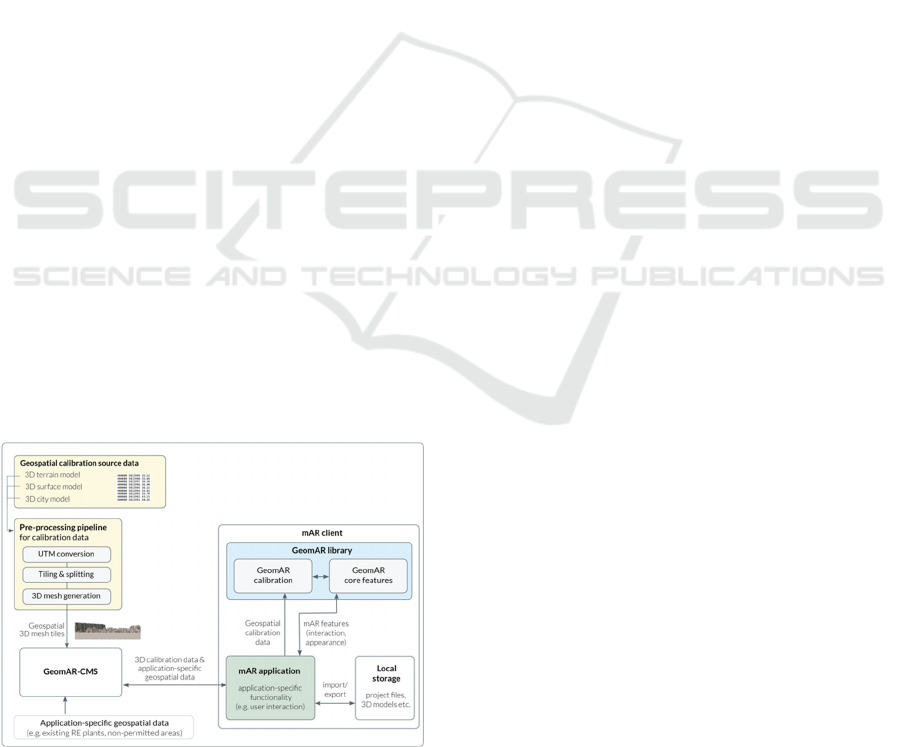
realize these functions, the application
component uses several application-
independent components (Local Storage,
GeoCMS as well as GeoAR Library).
• Local Storage: Previously stored AR views,
3D models of the wind turbines as well as
temporarily stored calibration data are stored
locally within the AR client and can be loaded
from there into the mAR application.
• GeoAR Library: This client-side library
provides all necessary GeoAR core
functionalities (placement and manipulation of
virtual wind turbine models) as well as
functions for device calibration (geo-
localization). The technology used for device
calibration is presented in detail in section 4.3.
2) GeomAR-CMS: The main task of this server-
based component is the storage and administration of
geospatial data needed to run the mAR application.
For this purpose, this server component provides:
• on the one hand, interfaces to add, modify, and
retrieve application-specific geospatial data
(e.g., wind turbine data) as well as geospatial
data needed for device calibration (e.g., 3D
terrain models) (REST API and GUI front-end
for administration), and
• on the other hand, a database for persistent
storage of geospatial data.
3) Pre-processing Pipeline for Geospatial Data:
Since 3D geospatial data for device calibration is
often not initially available in formats suitable for
immediate server-based storage and AR integration,
the overall system also includes an offline component
to convert the 3D geospatial data into smaller-scale
3D tiles that can be efficiently displayed as a 3D
model (3D mesh) in the mobile AR client (see Section
4.2).
Figure 1: Architecture and interfaces of the mAR app.
4.2 Geospatial Data Pipeline
The component for converting 3D geospatial data into
AR-enabled 3D models for manual AR calibration is
designed to support three different types of 3D
geospatial data that virtually represent the user's
outdoor environment, each with different properties
and resolutions:
• Digital Surface Model (DSM): 3D point cloud
commonly acquired by LiDAR systems to
model the earth's surface including immobile
objects (vegetation, buildings).
• Digital Terrain Model (DTM): Description of
the earth's surface excluding vegetation and
man-made features.
• Digital 3D City Model: three-dimensional
description of building outlines (3D building
models).
Both the type of geospatial data used for calibration
and the extent of the area covered by the virtual
models can be determined by the user based on the
spatial nature of the environment (e.g., rural vs.
urban) and the availability of each geospatial model
(e.g., 3D city model in urban areas and 3D terrain
model in mountainous areas with distant views).
Usually, 3D data is provided in text-based form
by GIS data providers. To convert them into 3D
models suitable for AR display within the mobile AR
client, several conversion steps are required:
UTM Conversion: First, the source data is
transformed into a Universal Transverse Mercator
(UTM) coordinate system that uses a metric grid
(meter).
Tiling & Splitting: For more efficient data
handling, the source files are then split into smaller
parts with defined square dimensions. This way,
when rendering the virtual user environment, the
mobile client only needs to load and process tiles with
smaller file sizes. This processing step employs a
customized naïve tiling approach without
incorporating open standards for 3D tiles.
3D Mesh Generation: Using incremental
Delaunay triangulation (Heckbert & Garland, 1997),
the generated 3D tiles are finally transformed into
optimized Triangulated Irregular Network (TIN)
surface meshes with different levels of detail.
Wavefront OBJ is used as the target file format for the
textureless 3D meshes.
Storage in GeomAR-CMS: These obj files are
finally stored in the server-based management system
(GeomAR-CMS) together with the associated
metadata (position, size and type of 3D tile). From
there, they can be provided to the mobile AR client
on demand.
Mobile Outdoor AR Application for Precise Visualization of Wind Turbines using Digital Surface Models
19
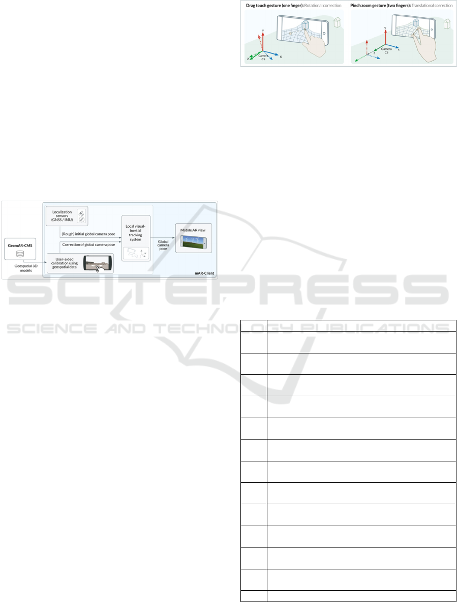
4.3 AR Registration and Calibration
Accurate determination of global camera position and
orientation (global camera registration) is a key
requirement for accurate AR visualizations in outdoor
mobile AR applications. In the system presented here,
a novel user-assisted registration method was
developed that uses georeferenced 3D data to
accurately register mobile devices with respect to a
global geo-reference system (geo-coordinate system).
Before starting this user-driven calibration
process, suitable 3D geospatial models of the user
environment are first loaded as calibration data from
the GeomAR-CMS. An initial rough estimation of the
device position and orientation is possible using the
localization sensors (GNSS receiver for rough
position determination and IMU sensor for rough
determination of the device orientation) installed in
the mobile device (see Figure 2).
Figure 2: Real-time registration and tracking system.
Thus, the 3D geospatial models can be displayed
as a rough - but usually still very flawed - virtual 3D
projection of the user's environment in the camera
image, e.g., as a rough virtual representation of the
terrain surface structure or the 3D structures of nearby
buildings. Then, the user manually moves the
projected 3D environment on the screen to match the
actual real-world view in the live camera video. Using
two common mobile touch gestures (drag-touch and
pinch-zoom gestures), the generated virtual models
can be interactively aligned to match the actual
perception of the real environment (see Figure 3.):
• A drag-touch gesture (one finger) can be used
to move the virtual geospatial model on the
screen, resulting in a rotation correction of the
global camera orientation.
• A pinch-zoom gesture (two fingers) can be
used to scale the virtual geospatial model,
resulting in a correction of the global camera
position.
This user-controlled shift of the virtual environment
thus leads to a correction of the global device position
and orientation. In addition, a state-of-the-art image-
based tracking system (visual inertial odometry
system; VIO tracking) continuously tracks device
movements in the local space in the background. This
ensures a consistently stable AR projection of the
virtual user environment without drift effects.
Figure 3: User interaction gestures for aligning the virtual
geospatial data models to correct global camera orientation
(left) and position (right).
5 MOBILE AR-APPLICATION
FOR THE VISUALIZATION OF
WIND TURBINES
The following section will describe the functionalities
and interface design of the mAR app for 3D
visualization of wind turbines in the landscape. The
functionalities and graphical user interface were
developed based on requirements identified in
discussions and workshops with representatives of
user groups. A structured overview of the collected
requirements is presented in Table 1.
Table 1: Functional requirements for a mAR app for
visualization of planned wind energy plants.
No. Re
q
uirement
R1
Placement of planned wind turbines on map and
in camera image.
R2
mAR visualization of planned wind turbines as
a 3D model.
R3
Precise and correct placement of AR content in
camera ima
g
e.
R4
mAR visualization of wind turbine rotor
movement in 3D model
(
animation
)
R5
Simultaneous mAR visualization of multiple
p
lanned WTs.
R6
mAR visualization of meta data of a planned
wind turbines
R7
Modification of the appearance of the planned
wind turbine
(
model t
yp
e and hei
g
ht
)
R8
Modification of the orientation and location of
the planned wind turbines
R9
Consideration of non-permitted areas when
p
lacin
g
wind turbines
R10
mAR visualization of planned wind turbines as
POI markers
R11
mAR visualization of already existing
renewable energy
p
lants as POI markers
R12
Local import/export of the current mAR
p
lanning configuration
R13 Video recording of the current AR view
GISTAM 2022 - 8th International Conference on Geographical Information Systems Theory, Applications and Management
20
Table 1: Functional requirements for a mAR app for
visualization of planned wind energy plants (Cont.).
R14
Mobile AR hardware without special sensor
technology (commercially available
smartphones/tablets)
R15
Server-based data provision and online
ca
p
abilit
y
.
With the designed graphical user interface (GUI) of
the mAR application for visualization of planned
wind turbines, all essential functional requirements
were implemented. The designed screen designs as
well as their interrelationships are shown in Figure 4.
Figure 4: Graphical user interface (GUI) designs for a
mobile app for mAR visualization of wind turbines.
They are briefly described in the following:
Start Screen: This is the first screen after
launching the application. It provides a quick
selection of the last saved AR visualizations (AR
projects), the option to open the calibration data
management and view app information, and the
option to start the main AR functions (visualizing
virtual wind turbines as well as AR information about
existing renewable energy plants).
Calibration Data Management: Before AR
rendering of virtual content is possible, AR
calibration data of the environment (e.g., 3D
geospatial models) must be loaded. A dedicated
screen provides expert options for custom display,
loading, and activation of individual calibration data.
AR Calibration: As prerequisite for precise AR
visualizations a manual calibration needs to be
performed to precisely register the AR display
globally. During calibration, the AR view is to be
aligned via user interaction so that the virtual view
and the real view match. This is done by moving the
virtual calibration objects (3D geospatial models).
The user can also open a settings menu in the AR
calibration view to determine the type of calibration
data to be displayed. After manual alignment is
complete, the user confirms the calibration, which
launches the main AR view.
View Virtual Wind Turbine Models in the
Landscape (AR Main View): On this main screen,
one or more wind turbines are displayed using AR
visualization at specified geographical positions in
the camera view. Depending on the distance, the
display is either a 3D model or a POI. From this main
view, further functionalities related to AR
visualization of wind turbines in the landscape can be
started via button.
Adding a New Virtual Wind Turbine to the AR
View: In the AR main view, a new wind turbine
model can be added in the user's field of view via
button. Clicking the "New wind turbine" button will
automatically add a standard wind turbine model
directly in the user's field of view to the AR view.
Changing the Location (Position) of the Wind
Turbine Model: Via a map view, the position of the
placed virtual wind turbines can be adjusted
manually. Unsuitable areas are marked accordingly
on the map via map overlay. By moving a wind
turbine icon in the map view, the global position of
the virtual model changes. This is immediately
reflected in the AR view.
Changing the Appearance of the Wind
Turbine Model: The user has the possibility to
change the size (height), the orientation (rotation) as
well as the model of the virtually placed wind turbines
in order to view or compare the effects of wind
turbines with different appearance or height. For this
purpose, the user selects a placed wind turbine model
in the AR view or the map view, so that a wind turbine
settings menu appears. There, a 3D wind turbine
model can be selected from a list of predefined 3D
models and the size (hub height) and orientation can
be specified.
Loading and Saving AR Projects: The current
AR configuration, i.e. the wind turbine models
(location and appearance) currently placed in the AR
view, can be saved as a project file in order to restore
and view this AR configuration at another time and/or
location.
View Existing Renewable Energy Plants as AR
POI Representation: The user has the possibility via
button in the start screen to view meta-information
about relevant renewable energy plants in the
surrounding area as POI-AR representation to get an
impression of availability and type of renewable
energy plants in the surrounding area. When clicking
on an AR POI marker, the marker view expands with
additional meta-information about the selected plant.
Clicking on a "list button" opens a (non-AR-based)
Mobile Outdoor AR Application for Precise Visualization of Wind Turbines using Digital Surface Models
21
list view of renewable energy plants in the
surrounding area.
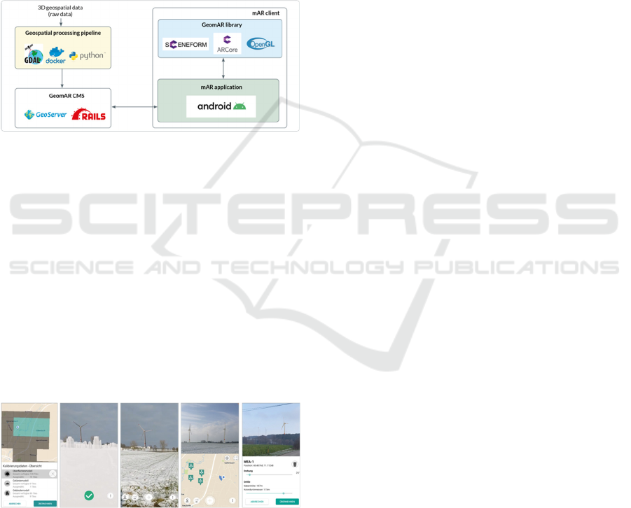
6 IMPLEMENTATION
The presented components for the realization of the
mobile application were implemented for usage on
commercially available smartphones and tablets
within predefined test areas (Land Berlin and region
Augsburg). Users of the application thus receive an
impression of the potential impact of newly planned
wind turbines on the landscape within these areas.
Figure 5: Technologies used in the implementation of the
mAR system.
The app was implemented as a native Android mobile
application that can run on commercially available
mobile devices with built-in IMU and GNSS sensors
and using Google ARCore SDK as a local VIO
tracking system. The rendering of the AR content in
the camera image was realized OpenGL-based using
the Sceneform SDK. The raw data of the 3D
geospatial models for AR calibration were provided
by the Bavarian Surveying Administration (LDBV)
for testing purposes as part of the research work.
Alternatively, the - often freely available - raw data
of other state surveying offices can be integrated in
the same way.
Figure 6: Screenshots from the mAR app - manage
calibration data, move 3D geospatial models, display wind
turbine as AR visualization, place wind turbine, modify
appearance of wind turbine.
The geospatial data pipeline was realized based on
open-source tools for geospatial data processing, in
particular based on the GDAL library. These tools
were encapsulated in Docker containers and
automated using Python scripts. The GeomAR-CMS
for geospatial data management, storage, and
provisioning was implemented based on the
GeoServer software and using a Ruby-on-Rails web
framework. Figure 5 shows an overview of the
technologies used in the system. Screenshots from the
implemented application can be seen in Figure 6.
7 EVALUATION
The functionality of the mAR app as well as the GUI
were developed from the very beginning in
cooperation with representatives of the target user
group. In initial tests with potential end users, the app
was evaluated positively. In particular, the realistic
visualization as well as the correct, robust positioning
of the wind turbines were emphasized. In particular,
the high degree of realism is achieved due to the
positionally accurate integration of 3D environment
models leading to correct considerations of possible
occlusions of the wind turbines through vegetation,
terrain or buildings.
The additional manual effort for the user required
for calibration, i.e., correcting the position and
orientation of the wind turbines, was rated as
acceptable. This manual effort does not make the app
as easy to use as users would like, but due to the
inaccuracies of the sensors on commercially available
mobile devices, such additional calibration effort is
mandatory to ensure correct visualization. While this
provides a source of error due to incorrect use, similar
user errors can occur with other visualization methods
(e.g., photomontages). The experimental results have
nevertheless shown that the user-driven calibration
approach - combined with a robust local VIO tracking
system - can achieve efficient and accurate global
registration of mobile devices in various outdoor
environments and with reasonable user effort,
determining the device’s orientation with less than
one degree deviation.
Also, our approach enables a fast global
registration solution as the shifting of the pre-loaded
virtual environment models to the correct on-screen
position can be achieved ideally within a few seconds.
This process therefore is not simpler and more
straightforward, but also more time-saving compared
to other similar manual calibration techniques, e.g.,
the approach developed by Kilimann et al. (2019)
where the user has to manually select suitable
landmarks as reference points on a map and before
moving them in the camera image to the correct
position.
GISTAM 2022 - 8th International Conference on Geographical Information Systems Theory, Applications and Management
22

8 SUMMARY AND OUTLOOK
The objective of this paper was the development of a
mobile mAR application for the visualization of
planned wind turbines. For this purpose, the functions
of the mAR app were designed, implemented and
evaluated. In particular, the underlying technical
concepts of the geospatial data pipeline for the
generation of AR-suitable 3D geospatial models and
the global registration approach for correct
positioning of the mAR objects in the camera image
were explained.
The major advantage of a mAR app - especially
compared to classical visualization processes - lies in
an easier and immediate visualization on-site in the
real application context. Using the example of the
visualization of planned wind turbines, this more
flexible visualization technique could be clearly
demonstrated. However, this advantage could also be
used for further mAR applications in the renewable
energy sector, e.g., for the mAR representation of
planned power lines or photovoltaic systems.
Limitations of the proposed solution arise from
the complexity of the geospatial data incorporation as
well as the partial lack of availability of such data. In
order to make the geospatial data available for large-
scale areas, large infrastructure has to be available to
manage and provide these data. In this work, the
application has only been tested in a small test area as
the focus was on the technical feasibility and the
implementation of the functional requirements.
In order to achieve greater practicality and appeal
to broader user groups, the next step would also need
to focus more on usability - especially for non-
experts. In this context, a more intensive user
evaluation is planned in the next step to identify and
implement optimization approaches for better
usability and to make the calibration process easier
and more user-friendly. These possible further
developments also include the idea of integrating and
testing additional types of geospatial 3D models, e.g.,
textured colored surface and city models.
ACKNOWLEDGEMENTS
The authors gratefully acknowledge financial support
from the German Federal Ministry of Education and
Research (BMBF) within the research project
"mARGo" (grant number 01IS17090B) and the
German Federal Ministry for Economic Affairs and
Energy (BMWi) within the research project
"AR4WIND" (grant number 03EE3046B). In
addition, the authors would like to express their
sincere thanks to the Bavarian State Office for the
Environment and the Bavarian State Ministry of
Economic Affairs, Regional Development and
Energy for their very fruitful cooperation and support,
as well as to the Bavarian Surveying Administration
for providing the 3D geospatial data used for the AR
calibration.
REFERENCES
Agentur für erneuerbare Energien (2019). Akzeptanz-
Umfrage 2019 - Wichtig für den Kampf gegen
den Klimawandel: Bürger*innen wollen mehr
Erneuerbare Energien. https://www.unendlich-viel-
energie.de/themen/akzeptanz-erneuerbarer/akzeptanz-
umfrage/akzeptanzumfrage-2019.
Baatz, G., Saurer, O., Köser, K., & Pollefeys, M. (2012).
Large Scale Visual Geo-Localization of Images in
Mountainous Terrain. In A. Fitzgibbon, S. Lazebnik, P.
Perona, Y. Sato & C. Schmid (eds.), Computer Vision
– ECCV 2012. Lecture Notes in Computer Science,
Vol. 7573 (pp. 517-530). Berlin, Heidelberg: Springer.
https://doi.org/10.1007/978-3-642-33709-3_37
Brejcha, J., Lukáč, M., Hold-Geoffroy, Y., Wang, O., &
Čadík, M. (2020). LandscapeAR: Large Scale Outdoor
Augmented Reality by Matching Photographs with
Terrain Models Using Learned Descriptors. In A.
Vedaldi, H. Bischof, T. Brox, & J.M. Frahm (eds.)
Computer Vision – ECCV 2020. Lecture Notes in
Computer Science, Vol. 12374 (pp. 295-312). Cham:
Springer. https://doi.org/10.1007/978-3-030-58526-
6_18
Burkard, S., Fuchs-Kittowski, F., Abecker, A., Heise, F.,
Miller, R., Runte, K., & Hosenfeld, F. (2021).
Grundbegriffe, Anwendungsbeispiele und
Nutzungspotenziale von geodatenbasierter mobiler
Augmented Reality. In U. Freitag, F. Fuchs-Kittowski,
A. Abecker, & F. Hosenfeld (eds.),
Umweltinformationssysteme
‐
Wie verändert die
Digitalisierung unsere Gesellschaft? (pp. 243-260).
Wiesbaden: Springer Vieweg. https://doi.org/10.1007/
978-3-658-30889-6_15
Fuchs-Kittowski, & F., Burkard, S. (2019). Potential
Analysis for the Identification of Application Scenarios
for Mobile Augmented Reality Technologies - with an
Example from Water Management. In R. Schaldach,
KH. Simon, J. Weismüller, & V. Wohlgemuth (eds.),
Environmental Informatics - Computational
Sustainability: ICT methods to achieve the UN
Sustainable Development Goals (pp. 372-380).
Aachen: Shaker.
Gazcón, N.F., Nagel, JMT., Bjerg, EA., & Castro, SM.
(2018). Fieldwork in Geosciences assisted by ARGeo:
A mobile augmented reality system. Computers &
Geosciences, 121, 30–38. https://doi.org/10.1016/
j.cageo.2018.09.004
Mobile Outdoor AR Application for Precise Visualization of Wind Turbines using Digital Surface Models
23

Haynes, P., Hehl-Lange, S., & Lange, E. (2018). Mobile
Augmented Reality for Flood Visualisation.
Environmental Modelling and Software, 109, 380-389.
https://doi.org/10.1016/j.envsoft.2018.05.012
Heckbert, P.S., & Garland, M., (1997). Survey of polygonal
surface simplification algorithms. Technical report,
Pittsburgh: Carnegie-Mellon University.
Höllerer, T., & Feiner, S. (2004). Mobile augmented reality.
In H. Karimi & A. Hammad (eds.): Telegeoinformatics:
Location-based computing and services (pp. 221-260).
London: Taylor & Francis Books Ltd.
Hoult, C. (2012). Geospatial Data for Augmented Reality.
In AGI GeoCommunity '12: Sharing the Power of
Place, Association for Geographic Information,
https://citeseerx.ist.psu.edu/viewdoc/download?doi=10
.1.1.367.9092&rep=rep1&type=pdf
Hugues, O., J.-M. Cieutat, & P. Guitton (2011). Gis and
augmented reality: State of the art and issues In B. Furth
(ed.), Handbook of augmented reality (pp. 721-740),
New York: Springer. https://doi.org/10.1007/978-1-
4614-0064-6_33
Hübner, G., Pohl, J., Warode, J., Gotchev, B., Nanz, P.,
Ohlhorst, D., Krug, M., Salecki, S., & Peters, W.
(2019). Naturverträgliche Energiewende. Akzeptanz
und Erfahrungen vor Ort. Bonn: Bundesamt für
Naturschutz (BfN).
Kilimann, J.E., Heitkamp, D., & Lensing, P. (2019). An
Augmented Reality Application for Mobile
Visualization of GIS-Referenced Landscape Planning
Projects. In 17th International Conference on Virtual-
Reality Continuum and its Applications in Industry
(VRCAI 2019). (article 23, pp. 1-5). New York: ACM,
https://doi.org/10.1145/3359997.3365712
Kim, K., Billinghurst, M., Bruder, G., Duh, H., & Welch,
G. (2018). Revisiting Trends in Augmented Reality
Research: A Review of the 2nd Decade of ISMAR
(2008–2017). IEEE Transactions on Visualization and
Computer Graphics, 24(11), 2947-2962.
https://doi.org/10.1109/TVCG.2018.2868591
Langlotz, T., Mooslechner, S., Zollmann, S., Degendorfer,
C., Reitmayr, G., & Schmalstieg, D. (2012). Sketching
up the world: In-situ authoring for mobile augmented
reality. Personal and Ubiquitous Computing, 16, 623–
630.
Liu, R., Zhang, J., Chen, S., & Arth, C. (2019). Towards
SLAM-Based Outdoor Localization using Poor
GPS and 2.5D Building Models. IEEE
International Symposium on Mixed and Augmented
Reality (ISMAR2019), (1-7). https://doi.org/10.1109/
ISMAR.2019.00016
Nefzger, A. (2018). 3D-Visualisierung von
Windenergieanlagen in der Landschaft –
Webanwendung „3D-Analyse“. In U. Freitag, F. Fuchs-
Kittowski, F. Hosenfeld, A. Abecker, & A. Reineke
(eds.), Umweltinformationssysteme 2018 -
Umweltbeobachtung: Nah und Fern (pp. 159 – 177).
Nürnberg: CEUR-WS.org, Vol. 2197. http://ceur-
ws.org/Vol-2197/paper12.pdf.
Panou, C., Ragia, L., Dimelli, D., & Mania, K. (2018).
Outdoors Mobile Augmented Reality Application
Visualizing 3D Reconstructed Historical Monuments.
In 4th International Conference on Geographical
Information Systems Theory, Applications and
Management (GISTAM), (59-67) Scitepress.
https://doi.org/10.5220/0006701800590067
Rambach, J.R., Lilligreen, G., Schäfer, A., Bankanal, R.,
Wiebel, A., & Stricker, D. (2021). A Survey on
Applications of Augmented, Mixed and Virtual Reality
for Nature and Environment. In 23rd International
Conference on Human-Computer Interaction (HCII-
2021), Springer. https://arxiv.org/pdf/2008.12024.pdf
Schall, G., Mendez, E., Kruijff, E., Veas, E., Junghanns, S.,
Reitinger, B., & Schmalstieg, D. (2009). Handheld
augmented reality for underground infrastructure
visualization. Personal and Ubiquitous Computing, 13,
281–291.
Schall, G., Zollmann, S., & Reitmayr, G. (2013). Smart
Vidente: advances in mobile augmented reality for
interactive visualization of underground infrastructure.
Personal and Ubiquitous Computing, 17(7), 1533–
1549. https://doi.org/10.1007/s00779-012-0599-x
Schmid, F., & Langerenken, D. (2014). Augmented reality
and GIS: On the possibilities and limits of markerless
AR. In Huerta, J., Schade, S., & Granell, C. (eds.):
Connecting a Digital Europe through Location and
Place. 17th AGILE International Conference on
Geographic Information Science. https://agile-
online.org/conference_paper/cds/agile_2014/agile2014
_87.pdf
Szymanek, L., & Simmons, D. R. (2015). The effectiveness
of augmented reality in enhancing the experience of
visual impact assessment for wind turbine
development. In 38
th
European Conference of
Visual Perception. Glasgow. https://doi.org/10.7490/
f1000research.1110764.1
Soldati, F. (2021). PeakFinder AR.
http://www.peakfinder.org/mobile
Zamir, A.R., Hakeem, A., Van Gool, L., Shah, M., &
Szeliski. R. (2018). Large-Scale Visual Geo-
Localization. Advances in Computer Vision and Pattern
Recognition, Basel: Springer.
Zollmann, S., Hoppe, C., Kluckner, S., Poglitsch, C.
Bischof, H., & Reitmayr, G. (2014). Augmented
Reality for Construction Site Monitoring and
Documentation. Proceedings of the IEEE, 102(2), 137-
154. https://doi.org/10.1109/JPROC.2013.2294314
GISTAM 2022 - 8th International Conference on Geographical Information Systems Theory, Applications and Management
24
