
Impact Analysis of Landscape Pattern Evolution on Runoff Variation
in the Yellow River Basin of Qinghai Province based on LUCC
Chuanhang Zhang
1,2
,*
, Jiwei Zhu
1,2
, Nan Lu
1,2
and Jiangrui Wang
1,2
1
State Key Laboratory of Eco-hydraulics in Northwest Arid Region of China, Xi'an University of Technology, Xi'an, China
2
Research Center of Eco-hydraulics and Sustainable Development, The New Style Think Tank of Shaanxi Universities,
Xi'an, China
Keywords: The Yellow River Basin of Qinghai Province, Land-use, Landscape Pattern, Runoff Variation
Abstract: The Yellow River Basin in Qinghai Province is the practice area of national environmental protection priority.
In recent years, with the influence of climate change and human activities, the landscape pattern and runoff
in the region have changed significantly. This paper conducts the following research to explore the influence
of regional landscape pattern variation on runoff change. Firstly, the average sliding method is used to analyze
the interannual variation trend of runoff in the study area. Secondly, the landscape pattern change is analyzed
by land-use transfer matrix and landscape pattern index. Finally, the Pearson correlation coefficient method
is used to analyze the influence of landscape pattern changes on runoff change. The results show that, unused
land and grassland are the main conversion objects. The dominant role of grassland as the dominant type of
landscape is gradually increasing, and each patch type tends to gather, which plays a certain role in promoting
the formation of surface runoff. In 1995-2005, the extent of land desertification increased, and the area of
grassland degraded to unused land was 3704.63 km
2
. The patch types were continuously dispersed and
fragmented, and the blocking effect on surface runoff was enhanced. During 2005-2018, unused land was
substantially converted into grassland due to the implementation of environmental protection projects.
Shannon diversity index decreased from 0.9946 to 0.9278. The decrease of landscape heterogeneity played a
certain role in promoting the formation of surface runoff.
1 INTRODUCTION
With the increase of human activity impacts, the land-
use types of the Yellow River Basin (YRB) in
Qinghai Province have undergone major changes in
the late 1990s (Chen et al., 2020). Watershed runoff
no longer shows typical temporal characteristics with
climate change, and to a certain extent, the influence
of human activities is superimposed (Xu et al., 2020;
Liu et al., 2020). Human activities transformed the
regional landscape pattern (Wang et al., 2021). The
change of landscape pattern in the basin can
transform the soil infiltration and surface evaporation
of runoff, thereby affecting the runoff yield and
confluence mechanism of the basin (Liu et al., 2019).
The landscape index is a quantitative index reflecting
the information structure and spatial configuration of
landscape patterns (Ma et al., 2019). Many scholars
use it to quantify the response relationship between
landscape patterns and runoff (Zhang et al., 2021; Bin
et al., 2021). Luo et al. (2020) analyzed the changes
in land use and runoff in the upper and middle reaches
of the Huaihe River and concluded a specific
correlation between the two aspects. Li et al. (2020)
found that runoff in Yihe River Basin was
significantly correlated with the Landscape shape
index and Contagion Index. Xiao et al. (2017) found
that the landscape of the Fuzhou urban area gradually
developed to high fragmentation and complex shape,
and the retention effect of landscape pattern on
surface runoff gradually increased. These previous
studies have achieved plentiful results, which
provides an essential basis for the study of this paper.
But these studies mainly focus on small-scale areas
and are not representative. At present, the change
analysis of land-use types and landscape pattern in the
YRB in Qinghai Province is mostly based on
municipal and county administrative units (Zhu et al.,
2020). There is a lack of quantitative data comparison
in analyzing the impact of human activities on the
basin's runoff. Given this, based on previous studies,
this paper analyzes the water resources bulletin data
296
Zhang, C., Zhu, J., Lu, N. and Wang, J.
Impact Analysis of Landscape Pattern Evolution on Runoff Variation in the Yellow River Basin of Qinghai Province based on LUCC.
In Proceedings of the 7th International Conference on Water Resource and Environment (WRE 2021), pages 296-303
ISBN: 978-989-758-560-9; ISSN: 1755-1315
Copyright
c
2022 by SCITEPRESS – Science and Technology Publications, Lda. All rights reserved
of the study area from 1995 to 2018 and obtains the
variation trend of precipitation and runoff in a long
time series. The change characteristics of landscape
patterns in the study area are obtained using the land-
use transfer matrix and landscape pattern index. Then
Pearson correlation coefficient method is used to
quantitatively evaluate the impact of landscape
pattern change on runoff change.
2 OVERVIEW OF THE STUDY
AREA AND DATA SOURCES
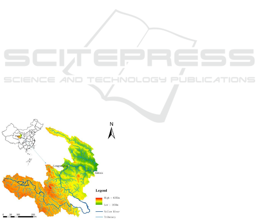
2.1 Overview of the Study Area
The YRB in Qinghai Province is located in eastern
Qinghai Province of China, which is located at 32°N–
39°N and 95°E–103°E. The range from the Yellow
River (YR) source to the Jishixia, including the YR
source area above the Longyangxia and the
mainstream area from the Longyangxia to the Jishixia
(Figure 1). The area is about 152,000km
2
, accounting
for 20% of the total area of the YRB. The region is
located in the ' roof of the world ' of the Qinghai-Tibet
Plateau, and is the upper YR ecological key
construction area, and is an essential part of the
Chinese water tower. There are 35 county-level
administrative regions in this region. The regional
ecological system structure is relatively simple,
mainly alpine meadow and alpine grassland meadow.
Permafrost developed, weak ability to resist external
interference, poor self-regulation. The climate
belongs to the plateau continental alpine climate. The
average annual precipitation is 250-800mm.
Figure 1: The YRB range and elevation map of Qinghai
Province.
2.2 Data Sources
This study obtained the area's 30m grid land-use data
in 1995, 2000, 2005, 2010, 2015, and 2018 through
the Resource and Environmental Science and Data
Center of the Chinese Academy of Sciences. It
includes six primary types of unused land, grassland,
water area, cultivated land, forest land, construction
land, and 25 secondary types of paddy fields, dry
land, high, medium, and low coverage grassland,
lakes, and towns. Combined with the boundary map
of the YRB in Qinghai Province, the land-use status
of the YRB in Qinghai Province in each year was
extracted by ARCGIS10.8.1 software and the
landscape pattern was analyzed by Fragstats4.2
software. Precipitation and runoff data are derived
from the water resources bulletin of Qinghai Province
from 1995 to 2018, and the annual average runoff
depth represents the size of annual runoff.
3 RESEARCH METHODS
Based on the research content, this paper firstly
analyzes the change trend of runoff in the study area.
In order to eliminate the influence of mutation factors
on runoff change, this paper mainly uses the average
sliding method to process the runoff data. Secondly,
based on the raster data of land-use in the study area,
the transfer matrix is selected to analyze the change
rules of land-use. Then based on the land-use data, the
landscape index is used to quantitatively analyze the
characteristics of landscape pattern change. Finally,
the Pearson correlation coefficient method is used to
explore the influence of landscape pattern change on
runoff change. The main research methods are as
follows:
3.1 Analysis of Land-use Change
Considering the mutual transformation of various
land types, in order to analyze the spatial
transformation of land types from 1995 to 2018, the
spatial change of land-use types is analyzed based on
the area transfer matrix method. The expression is as
follows:
𝑆
𝑆
⋯ 𝑆
⋮ ⋯ ⋮
𝑆
⋯ 𝑆
(1)
In the formula S represents the area of land-use
type, n represents the number of land-use types, i, j
represents the early and late land-use types of the
study.
Impact Analysis of Landscape Pattern Evolution on Runoff Variation in the Yellow River Basin of Qinghai Province based on LUCC
297
3.2 Analysis of Dynamic Change
Parameters of Landscape Pattern
In this study, with the help of Fragstats4.2, combined
with the ecological significance of each landscape
index and the purpose of this study, seven indexes
were selected, including Patch Density (PD),
Landscape Shape Index (LSI), Largest Patch Index
(LPI), Contagion Index (CONTAG), Shannon
Diversity Index (SHDI), Shannon Evenness Index
(SHEI) and Landscape Division Index (DIVISION).
Thus, the change characteristics of landscape pattern
in the study area were quantitatively analyzed.
3.3 Influence of Landscape Pattern
Evolution on Runoff Variation
Pearson correlation coefficient is a statistical method
that can quantitatively measure the correlation
between variables. In this paper, R is used to
characterize the correlation between landscape
pattern index and annual runoff. The calculation
method of Pearson correlation coefficient R is as
follows:
𝑅
∑
∑
/
∑
/
(2)
4 RESULTS
4.1 Variation Characteristics of Runoff
and Precipitation
According to the statistical data of runoff and
precipitation in the YRB in Qinghai Province from
1995 to 2018, the trend diagram of yearly runoff and
annual precipitation in the YRB in Qinghai Province
is drawn, as shown in Figure 2. Because the original
data fluctuates violently, the moving average method
investigates the diversification bent of rainfall and
runoff in long time series. Yearly precipitation and
annual flow variation trend are roughly the same, are
first slightly decreased and then gradually increased.
Precipitation is the chief reason for runoff variety.
The variation characteristics of precipitation and
runoff can be analyzed by calculating the anomaly
percentage of annual precipitation and annual runoff.
As shown in Figure 3, the fluctuation trends of
annual runoff and annual precipitation are the same,
showing positive and negative alternations. The
maximum and minimum annual precipitation
anomaly percentages are 30.13% (2018) and -22.93%
(2002), respectively. The maximum and minimum
annual runoff anomaly percentages are 54.24%
(2018) and -37.33% (2002). The changing trend of
year-long precipitation and annual runoff in the YRB
in Qinghai Province is roughly the same. Compared
with annual precipitation, the change range of annual
runoff is more significant. This shows that
precipitation is not the only factor affecting runoff
variation. The annual runoff change in the basin has a
certain relationship with human activities such as
land-use change. It is essential to analyze further the
influence of landscape pattern changes on runoff
changes.
Figure 2: Trends of annual runoff and annual precipitation
depth in the YRB in Qinghai Province from 1995 to 2018.
Figure 3: Variation characteristics of annual runoff and
annual precipitation depth anomaly percentage in the YRB
of Qinghai Province from 1995 to 2018.
4.2 Analysis of Land-use Change
Characteristics
As shown in Figure 4, the land-use structure of the
YRB in Qinghai Province is generally dominated by
grassland, which is widely distributed entirely in the
study area. Forest land is located in the mainstream of
the YRB, the relatively high southeast and north, and
unused land is mainly distributed in the source area.
WRE 2021 - The International Conference on Water Resource and Environment
298
Cultivated land and construction land are located in
the central part of the study area with relatively flat
terrain, close to the rivers in the area.
Figure 4: Land-use change of the YRB in Qinghai Province from 1995 to 2018.
As shown in Table 1, grassland and cultivated
land dimension decreased first and then increased
overall. The proportion decreased from 69.46% and
4.39% in 1995 to 68.60% and 4.22% in 2005 and then
increased to 73.44% and 4.41% in 2018. The
proportion of unused land and forest land is similar.
Unutilized land increases first and then decrease and
then maintains a stable trend. The proportion of forest
land has little change, which is maintained at about
10.50% on the whole. The proportion of water area
and construction land is small, and the overall trend
is rising year by year. Based on the above analysis,
the land-use types in the research area changed
significantly in 2005 and 2015. Therefore, this study
obtains the land-use transfer matrix of the YRB in
Qinghai Province from 1995 to 2005, 2005 to 2015,
and 2015 to 2018 by format conversion, matrix
operation, spatial superposition, and statistical
analysis in ArcGIS10.8.1. Analysis of their mutual
transformation of actual situation, as follows table 2.
During 1995-2005, due to the improvement of
regional urbanization and the construction of large-
scale water conservancy facilities, construction land
and water area explicated an increasing bent, while
grassland and cultivated land revealed a downward
trend. The cultivated land area converted into
construction land is 71.36km
2
, accounting for 83.04%
of the area transferred into construction land. The
grassland area converted to water was 189.45km
2
,
accounting for 60.25% of the area converted to water.
At the same time, under the influence of overgrazing
and climate warming, the phenomenon of
desertification in the study area is intensified. The
area of grassland degradation to unused land is
3704.63km
2
, accounting for 97.72% of the area
transferred from unused land.
From 2005 to 2015, with the implementation of
the westward growth strategy, the conversion of
farmland to the forest (grassland), and the ecological
protection construction project of the Sanjiangyuan,
on the one hand, the pace of urban construction in the
study area was further accelerated, and the
construction land increased from 602.41km
2
to
747.74km
2
. On the other hand, due to the ecological
protection and governance, the governance of land
degradation has been significantly strengthened, and
the degree of desertification has generally shown a
weakening trend. The regional grassland degradation
has been curbed, and the unused land has been
dramatically transformed into grassland, accounting
for 95.62% of the transferred grassland area.
Impact Analysis of Landscape Pattern Evolution on Runoff Variation in the Yellow River Basin of Qinghai Province based on LUCC
299
Table 1: Land-use type change in the YRB in Qinghai Province from 1995 to 2018.
Land-use type
Area ratio of land-use type to total study area
1995 2000 2005 2010 2015 2018
Cultivated land 4.39% 4.26% 4.22% 4.41% 4.37% 4.41%
Forest land 10.47% 10.51% 10.51% 10.50% 10.50% 10.50%
Grassland 69.46% 69.07% 68.60% 73.49% 73.48% 73.44%
Water area 2.14% 2.23% 2.25% 2.38% 2.39% 2.40%
Construction land 0.37% 0.38% 0.41% 0.45% 0.50% 0.48%
Unused land 13.17% 13.55% 14.02% 8.77% 8.76% 8.77%
Table 2-1: Land-use transfer matrix in the YRB in Qinghai Province from 1995 to 2005.
Land-use type
Conversion area of land-use type (km
2
)
Grassland
Construction
land
Cultivated
land
Forest
land
Water area
Unused
land
Total
2005
Grassland 100499.83 2.48 380.30 354.70 70.50 2426.83 103734.65
Construction land 10.89 516.49 71.36 1.18 1.01 1.49 602.42
Cultivated land 178.62 28.39 6010.07 10.55 14.32 14.27 6256.22
Forest land 424.06 1.64 7.55 15645.05 1.99 12.90 16093.19
Water area 189.45 1.59 33.40 9.07 3050.91 80.93 3365.35
Unused land 3704.63 0.26 10.01 16.77 59.34 17213.62 21004.63
Total 1995 105007.47 550.86 6512.69 16037.32 3198.08 19750.04 151056.45
Table 2-2: Land-use transfer matrix in the YRB in Qinghai Province from 2005 to 2015.
Land-use type
Conversion area of land-use type (km
2
)
Grassland
Construction
land
Cultivated
land
Forest
land
Water area
Unused
land
Total
2015
Grassland 101767.71 5.54 109.81 258.53 30.93 8829.93 111002.46
Construction land 68.17 580.91 85.34 2.07 6.24 5.00 747.74
Cultivated land 420.08 13.56 6023.62 12.32 12.22 3.50 6485.30
Forest land 244.45 0.42 8.12 15804.58 3.24 11.48 16072.29
Water area 84.68 1.92 28.23 5.59 3294.13 152.09 3566.64
Unused land 1142.66 0.04 0.91 9.31 18.27 11999.49 13170.69
Total 2005 103727.75 602.41 6256.04 16092.39 3365.03 21001.49 151045.12
Table 2-3: Land-use transfer matrix in the YRB in Qinghai Province from 2015 to 2018.
Land-use type
Conversion area of land-use type (km
2
)
Grassland
Construction
land
Cultivated
land
Forest
land
Water area
Unused
land
Total
2018
Grassland 109549.15 49.30 196.41 667.13 100.33 353.11 110915.44
Construction land 67.55 590.52 42.85 1.66 1.69 4.67 708.94
Cultivated land 195.43 101.03 6204.23 21.57 18.51 2.64 6543.41
Forest land 675.95 1.48 20.33 15352.27 12.11 14.09 16076.24
Water area 112.04 3.70 16.84 13.36 3413.22 23.31 3582.48
Unused land 380.97 1.65 2.65 12.63 17.70 12761.82 13177.43
Total 2015 110981.09 747.68 6483.32 16068.64 3563.57 13159.65 151003.94
From 2015 to 2018, the overall land-use types
were in a stable trend. Some construction land was
converted into cultivated land, and the transferred
area was 101.03km
2
, accounting for 64.28% of the
transferred area of construction land. This is due to
the 2015 Qinghai Province promulgated the
“Opinions on Further Strengthening Land
Management and Strictly Saving and Intensive Land
Use”. It is proposed to strengthen land management
of whole province, strictly save and intensive land
use, and promote cultivated land protection.
WRE 2021 - The International Conference on Water Resource and Environment
300
4.3 Dynamic Change Analysis of
Landscape Pattern
The land-use data of the YRB in Qinghai Province
from 1995 to 2018 were processed by ArcGIS10.8.1.
Then the landscape index of the study area was
calculated by Fragstats4.2. As shown in Table 3, the
Landscape Shape Index and Landscape Division
Index show a trend of first increase and then decrease,
indicating that the overall landscape pattern has
experienced a change from dispersion to
concentration. This is related to the interference of
human activities on the landscape from enhancement
to weakening, and the initially dispersed patch space
gradually gathers. Contagion Index first decreased
and then increased, from 62.4932% in 1995 to
61.9373% in 2005, indicating that the aggregation
degree of various landscape types in the study area
decreased. However, the Contagion Index increased
from 61.9373% to 65.7323% in 2005-2018,
indicating a significant increase in the aggregation of
landscape types. Shannon Diversity Index and
Shannon Evenness Index decreased from 0.9946 and
0.4861 to 0.9278 and 0.4391, respectively, indicating
that the control effect of a single component on the
landscape was enhanced, reflecting the weakening of
landscape heterogeneity during the study period. The
dominant role of grassland as a dominant type of
landscape increased gradually, mainly due to the
implementation of ecological, environmental
protection projects in recent years. The distribution of
various plaque types in the YRB in Qinghai Province
tends to gather in the landscape.
Table 3: Landscape index of the YRB in Qinghai Province from 1995 to 2018.
Year
PD
(piece/km
2
)
LSI LPI/% CONTAG/% DIVISION SHDI SHEI
1995 0.2084 169.8907 61.0481 62.4932 0.6266 0.9946 0.4861
2000 0.2076 171.1873 61.6805 62.2275 0.6190 1.0013 0.4903
2005 0.2083 172.1802 58.9134 61.9373 0.6519 1.0098 0.4956
2010 0.1703 140.4520 64.5149 65.8093 0.5830 0.9258 0.4384
2015 0.1693 139.7512 64.5957 65.7861 0.5820 0.9276 0.4387
2018 0.1720 140.9121 64.3829 65.7323 0.5845 0.9278 0.4391
4.4 Influence Analysis of Landscape
Pattern Evolution on Runoff
Variation
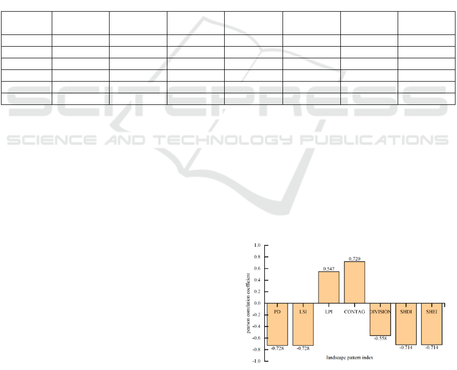
From the landscape level analysis, the Person
correlation coefficients between seven landscape
indices and annual runoff were calculated by SPSS
software, and the results were shown in Figure 5.
Annual runoff variation was negatively correlated
with PD, LSI, and DIVISION, indicating that with the
increase of landscape fragmentation, the landscape
types of the basin tend to be complex, and the
hindrance to surface runoff is enhanced. The LPI and
CONTAG were positively correlated with the change
of annual runoff, indicating that the dominant role of
landscape patches and the improvement of
aggregation between patches contribute to the
formation of surface runoff. In addition, the SHDI
and SHEI were negatively connected with annual
runoff, indicating that the types of landscape patches
were complicated, and the spatial distribution was
gradually uniform, delaying the formation of surface
runoff. In summary, from 1995 to 2005, due to the
improvement of urbanization level, overgrazing,
climate, and other factors, the interference of human
activities on landscape patterns was enhanced. The
types of patches were continuously dispersed and
fragmented, which enhanced the hindering effect on
surface runoff. During 2005–2018, due to the
implementation of environmental protection projects,
the fragmentation and heterogeneity of landscape
patterns in the YRB in Qinghai Province decreased,
and the dominance and polymerization degree
increased. Which played a certain role in promoting
surface runoff.
Figure 5: Influence of landscape index on runoff in the YRB
in Qinghai Province.
Impact Analysis of Landscape Pattern Evolution on Runoff Variation in the Yellow River Basin of Qinghai Province based on LUCC
301

From the analysis of patch types, the impact of
land-use change on the runoff process is mainly
reflected in the direct and indirect aspects. The direct
impact is reflected in the continued addition of water
area in the study area. Since 1980, the lake area of the
YRB in Qinghai Province began to turn and continue
to grow. At the same time, large hydropower stations
such as Longyangxia and Lijiaxia have been built.
The area of the reservoir area increases, and the water
conservation improves, which plays a certain role in
promoting surface runoff. The indirect effect is
mainly reflected in that the change of surface
structure will affect soil moisture storage, thereby
affecting the water cycle processes such as infiltration
and evaporation and ultimately affecting the runoff in
the study area. Grassland is the primary land type in
the YRB in Qinghai Province. After 2005, with the
project of returning farmland to the forest (grass) and
ecological protection of Three River Sources, the
grassland area has gradually increased. The increase
of grassland area promoted surface
evapotranspiration, increased the retention of
precipitation in the wet season, and played a role in
reducing runoff. Secondly, through the surface
evapotranspiration cycle, the increase of grassland
area is conducive to the formation of regional
precipitation. Since implementing the environmental
protection project, the change in atmospheric
circulation has caused an increase in precipitation.
The rainfall in the YRB in Qinghai Province has
developed year by year, which increases the runoff
and offsets the decrease of runoff caused by
ecological engineering. Therefore, the runoff in the
study area is still showing an increasing trend.
5 CONCLUSIONS AND
DISCUSSIONS
YRB in Qinghai Province is the core area of the
ecological barrier of the Qinghai-Tibet Plateau. The
ecological environment is fragile, and the influence of
human activities has gradually intensified in recent
years. Human activities drive landscape pattern
change by changing land-use types, and the change of
landscape pattern directly impacts the hydrological
process of the whole basin. Therefore, the analysis of
land-use and landscape pattern change and its impact
on runoff has essential reference value for the
regional ecological environment protection, rational
land development, and water resources management.
The variation trend of precipitation-runoff was
calculated in this study. The land-use transfer matrix
was used to analyze the land-use situation and the
landscape pattern index was used to analyze the
landscape pattern change. Finally, the influence of
landscape pattern change on runoff change was
analyzed by Pearson correlation coefficient method.
Through the above research and analysis, the
conclusions can be drawn as follows:
From 1995 to 2018, the overall change trends of
rainfall and runoff in the YRB in Qinghai Province
were similar, showing a slight decline and then a
gradual increase. Precipitation was not the only factor
affecting runoff variation. The annual runoff variation
was much more significant than the yearly
precipitation change.
Land desertification intensified and grasslands
gradually degraded into unused land in 1995-2005.
After 2005, unused land gradually transformed into
grassland. The overall trend of grassland decreased
firstly, and then increased, and unused land was the
opposite. The area of water area and construction land
was small and in an overall growth trend.
The analysis of landscape pattern evolutions in the
YRB in Qinghai Province from 1995 to 2018 showed
that the LSI, DIVISION, SHDI, and SHEI increased
at first and then decreased, and the CONTAG firstly
decreased and then increased. The landscape
heterogeneity was weakened, and the dominant role
of grassland as a landscape dominant type was
gradually increasing.
The annual runoff variation was negatively
correlated with the LSI and SHDI. The CONTAG
was positively correlated with the annual runoff
variation. The increase of water area and grassland
promoted the evaporation cycle of surface water,
which was contributory to the organization of
regional precipitation and played a certain role in
promoting runoff.
This study mainly analyzes the impact of
landscape pattern changes on runoff changes in the
YRB in Qinghai Province from a macro perspective.
It has not yet analyzed the mechanism from a micro
perspective. In future studies, the combined effects of
climate change and landscape patterns will be
considered. The simulation prediction model will be
used to explore the mechanism and influence of
landscape pattern evolution on surface runoff.
ACKNOWLEDGMENTS
This research was funded by Project of National
Natural Science Foundation of China (71774132),
Shaanxi Water Conservancy Science and Technology
Project (2020SLKJ-22), Shaanxi Provincial
WRE 2021 - The International Conference on Water Resource and Environment
302

Department of Education Key Scientific Research
Project (20JT053).
REFERENCES
Bin, L., Xu, K., Xu, X., Lian, J., & Ma, C. (2018).
Development of a landscape indicator to evaluate the
effect of landscape pattern on surface runoff in the
Haihe River Basin. Journal of Hydrology, 566, 546-
557.
Chen, Q., Zhang, Y. L., Liu, F. G., Zhou, Q., Wang, S. Z.,
Cheng, Y., Guo, R., Zhi, Z. M., & Xu, H. G. (2020). A
review of land use change and its influence in the source
region of the Yellow River. Resources Science, 42, 446-
459.
Li, Z. J., Liu, J. Y., Lu, C. X., & Su, N. (2020). Analysis of
the relationship between landscape pattern based on
land use change and runoff in Yihe River Basin.
Journal of China Agricultural University, 25, 11-19.
Liu, J., Xue, B., & Yan, Y. (2020). The Assessment of
Climate Change and Land-Use Influences on the
Runoff of a Typical Coastal Basin in Northern China.
Sustainability, 12(23), 10050.
Liu, F., Xiong, W., Wang, Y. H., Yu, P. T., & Xu, L. H.
(2019). Relationship between landscape pattern and
runoff based on LUCC in Jinghe river watershed.
Journal of Arid Land Resources and Environment, 33,
137-142.
Luo, D. X., Wang, J. B., Zheng, X. Z., & Chen, S. T. (2020).
Correlation Analysis of Land Usage Change and
Runoff in Upper and Middle Reaches of Huai River.
Journal of China Three Gorges University (Natural
Sciences), 42, 18-23.
Ma, L., Bo, J., Li, X., Fang, F., & Cheng, W. (2019).
Identifying key landscape pattern indices influencing
the ecological security of inland river basin: The middle
and lower reaches of Shule River Basin as an example.
Science of the Total Environment, 674, 424-438.
Wang, J., Zhao, C. W., He, Z. H., Tian, R. W., & Xu, Z. R.
(2021). Effect of Landscape Pattern Changes on Runoff
in Upstream of the Sancha River. Journal of University
of Jinan (Science and Technology), 35, 335-342.
Xiao, Y. H., Yang, C. X., Liu, Y. Y., Liu, Q. Y., Zhu, X. Y.,
& Huang, Q. T. (2017). Relationship between
Landscape Pattern and Surface Runoff in Fuzhou Based
on GIS. Water Resources and Power, 35, 14-18.
Xu, Y., Wang, S., Bai, X., Shu, D., & Tian, Y. (2018).
Runoff response to climate change and human activities
in a typical karst watershed, SW China. Plos One, 13(3),
e0193073
Zhang, Z., Chen, S., Wan, L., Cao, J., Zhang, Q., & Yang,
C. (2021). The effects of landscape pattern evolution on
runoff and sediment based on SWAT model.
Environmental Earth Sciences, 80, 1-12.
Zhu, J., Gong, J., & Li, J. Y. (2020). Spatiotemporal change
of habitat quality in ecologically sensitive areas of
eastern Qinghai-Tibet Plateau: A case study of the
Hehuang Valley, Qinghai Province. Resources Science,
42, 991-1003.
Impact Analysis of Landscape Pattern Evolution on Runoff Variation in the Yellow River Basin of Qinghai Province based on LUCC
303
