
Analysis of Channel Leakage Law in Piedmont Plain of Haihe River
Basin
Jingsi Zhu
1
, Zhe Wang
1
, Tianyu Hou
2,
* and Yu Li
1
1
Hydrology Bureau of Haihe River Water Conservancy Commission, MWR, Tianjin 300170, China
2
Tianjin Meteorological Bureau, TianJin 300000, China
Keywords:
Initial loss rate, Leakage loss, Leakage rate per unit river length
Abstract:
The channel leakage loss of piedmont plain in north China directly affects the flood evolution law and
ecological water diversion, especially in Haihe River Basin. The essay selected three typical river reaches of
the basin to analyze the leakage loss of the historical flood processes using statistical method, studying the
correlation between the leakage rate per unit river length and the upstream inflow, and the duration of flood
under different water storage conditions. Meanwhile, the initial leakage loss rate of flood with different
magnitude in each typical reach was estimated. The study results indicated: (1)The upstream inflow is
negatively correlated with the leakage rate per unit river length; the leakage rate per unit river length tends to
be stable when the upstream inflow increases to a certain value; (2)The duration of flood is negatively
correlated with the leakage rate per unit river length when there is bottom water; (3)The degree of dryness in
the early stage is one of the main factors affecting the seepage capacity; (4)The leakage rate per unit river
length is generally logarithmic or exponential related to the upstream inflow; (5)In Haihe River Basin, the
initial loss rate of medium and small water in typical reach is higher, more than 30%, and the initial loss rate
of large water is lower than that of medium and small water.
1 FOREWORD
The mutual conversion of surface water and
groundwater is a common natural phenomenon in
nature. The interaction between surface water and
groundwater has been regarded as one of the most
important and frontier research topics by the major
hydrology and water resources research institutions in
the world. Channel leakage is an important aspect of
surface water and groundwater exchange. The Haihe
River Basin (in north China) is semi - humid semi -
arid climate zone. There are many seasonal rivers in
the basin. The rivers are often dry up in the
discontinuous season. The basin has been in the
background of less rain since the "1996.08" flood, and
parts of the river have dried up for years. Therefore,
the flood leakage loss is large during the flood
routing, which changes the flood evolution process
and law under the natural state. Especially, the plain
channel leakage loss leads to prolonged flood
propagation time and significant increase of peak
clipping rate (Yu et al., 2017). Meanwhile, river
seepage is one of the important sources of
groundwater resources. Studying the law of channel
leakage loss in plain is of great significance for flood
evolution, ecological water diversion and
groundwater recharge. The research results provided
a basis for flood forecasting and management,
ecological water replenishment and other important
decisions.
At present, the research on channel leakage loss
estimation and simulation has achieved some
achievements. Boroughs & Abt (2003) evaluated
losses of river flows due to evaporation, seepage, and
transpiration, and empirical seasonal functions were
developed to relate flow loss to the flow rate in the
river. Grebenyukov (2002) choosed optimal
hydrogeological models for calculating seepage losses
from channels and rivers based on data of observations
performed in some parts of Kazakhstan. Yu, Ma, &
Fan (2017) summarized the research progress in the
simulation and calculation of channel leakage. Zhang,
Yan, & Cui (2002)
analyzed the correlation between
the upstream water, the recharge coefficient of river
infiltration and the loss rate of channel leakage in the
Hebei plain. Lu (2009) analyzed the channel seepage
characteristics using statistical method in piedmont
plain of Hebei province.
196
Zhu, J., Wang, Z., Hou, T. and Li, Y.
Analysis of Channel Leakage Law in Piedmont Plain of Haihe River Basin.
In Proceedings of the 7th International Conference on Water Resource and Environment (WRE 2021), pages 196-203
ISBN: 978-989-758-560-9; ISSN: 1755-1315
Copyright
c
2022 by SCITEPRESS – Science and Technology Publications, Lda. All rights reserved
Currently, hydraulic models or statistical analysis
are mainly methods used in the research of channel
leakage. But the hydraulic model is often hard to meet
the dual requirements of time and accuracy in the
actual flood prediction, evaluation of river recharge
groundwater, etc. This paper emphasized on the deep
integration of scientific research and practice.
Therefore, the statistical method was used to analyze
the leakage loss of typical river reaches in this paper.
This paper calculated the leakage loss per unit river
length, researched the correlation of the leakage rate
of unit river length and the upstream inflow, the
duration of flood under different water storage
conditions. Meanwhile, the initial leakage loss rate of
flood with different magnitude was estimated. The
research result was directly applied in the practical
work including flood prediction, evaluation of river
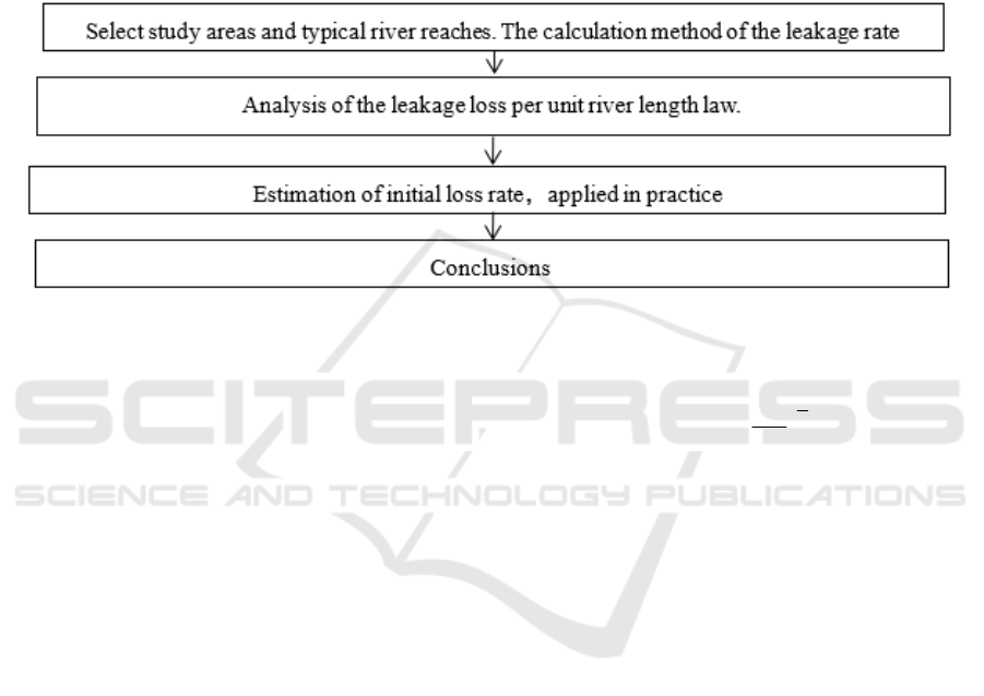
recharge groundwater. The flow chart is as follows
(Figure 1):
Figure 1: Flowchart.
2 CALCULATION METHOD AND
DATAUM
2.1 Calculation Method
During the evolution of a flood, the water loss
includes phreatic evaporation, vadose infiltration, and
leakage. Due to the small proportion of evaporation
and vadose infiltration in the process of flood
evolution, they are ignored in the analysis of water
loss. The channel leakage is expressed by the leakage
rate per unit river length. When the leakage rate per
unit river length is constant, the downstream section
flow is calculated using the upstream section inflow
and the leakage rate per unit river length (Eq. 1)
(Zhang et al., 2002).
(1 )
L
du
WW
(1)
In the formula:
u
W
—the upstream inflow, Billion
cubic meters;
d
W
—the downstream inflow, Billion
cubic meters;
—the leakage rate of unit river
length, ‰; L——length of the river, km.
The calculation formula of leakage rate per unit
river length is (Eq. 2) :
1
1( )
d
L
u
W
W
(2)
2.2 Datum
The typical river reach should meet the following
requirements:
(1) Representation of reaches. The interval inflow
in typical river reach is negligible.
(2) Integrity of datum. The data series is long, and
there are several years of flood processes.
(3) Applicability of results. The typical reach of
different rivers was compared to analyze the common
law of leakage loss under different underlying surface
conditions.
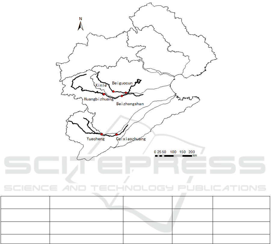
Based on the above principles, this paper selected
three typical river reaches in the Haihe River Basin.
Yuecheng Reservoir~Caixiaozhuang located in
Zhanghe River, Huangbizhuang Reservoir~
Beizhongshan located in Hutuo River, Xinle ~
Beiguocun located in Sha River. The positions of the
three typical river reach in the Haihe River Basin are
shown in Figure 2.
The three river reaches are all located in areas
where human activities are concentrated. In recent
years, due to the influence of upstream water
diversion and impoundment projects, the inflow of
Analysis of Channel Leakage Law in Piedmont Plain of Haihe River Basin
197
the river reach has decreased sharply, leading to the
increased number of cut off days. All three reaches
are wide and shallow sandy beds. The basic
information and datum of the three reaches are shown
in Table 1.
Figure 2: Locations of typical river reaches.
Table 1: The basic information and datum of the reaches.
The serial number The name of reach
The length of
reach/km
Data time
Quantity of
data/
g
rou
p
s
1
Yuecheng Reservoir ~
Caixiaozhuang
76 1967-2016 21
2
Huangbizhuang Reservoir~
Beizhongshan
110 1963-2018 15
3 Xinle ~ Beiguocun 55 1965-2013 16
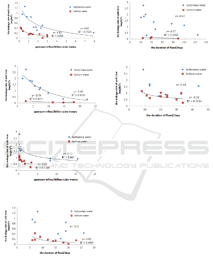
3 ANALYSIS OF LEAKAGE LAW
3.1 Law of Leakage Loss Per Unit
River Length
The main factors affecting the leakage rate of unit
river length are: the water storage conditions of the
channel before flood, the lithology of the riverbed, the
size of the inflow, the duration of the flood, and the
hydraulic conditions (Qin, 1989; Sun et al., 2010).
The water storage conditions of the channel before
flood includes bottom water and bottomless water.
The channel leakage loss with bottomless water
includes initial leakage loss and steady leakage loss.
The channel leakage loss with bottom water is steady
leakage loss. In this paper, the correlation analysis
between the upstream inflow, the duration of flood
and the leakage rate per unit river length is carried out
respectively under the condition of bottom water and
bottomless water. Figure 3 is correlation diagram of
upstream inflow and leakage rate per unit river length
in three typical river reaches. Figure 4 is correlation
diagram of the flood duration and leakage rate per
unit river length in three typical river reaches.
WRE 2021 - The International Conference on Water Resource and Environment
198
(a) Yuecheng Reservoir ~ Caixiaozhuang located in
Zhanghe River
(b) Huangbizhuang Reservoir~ Beizhongshan
located in Hutuo River
(c) Xinle ~ Beiguocun located in Sha River
Figure 3: Correlation diagram of upstream inflow and
leakage rate per unit river length.
(a) Yuecheng Reservoir ~ Caixiaozhuang located in
Zhanghe River
(b) Huangbizhuang Reservoir ~ Beizhongshan
located in Hutuo River
(c)
Xinle ~ Beiguocun located in Sha River
Figure 4: Correlation diagram of the flood duration and
leakage rate per unit river length.
From Figure 3 and Figure 4:
(1) The upstream inflow is negatively correlated
with the leakage rate per unit river length. The
leakage rate per unit river length tends to be stable
when the upstream inflow increases to a certain value.
Generally, the leakage loss is greater with the
increase of upstream inflow. But the relationship
between inflow and leakage rate is not the case(Lu,
S.Y.,2009). There is a significant negative correlation
between upstream inflow and leakage rate per unit
river length under the conditions of bottom water and
bottomless water. With the increase of upstream
inflow, the leakage rate per unit river length decreases
gradually. The leakage rate per unit river length tends
to be stable when the upstream inflow increases to a
certain value, which indicated that the channel
leakage rate is close to the leakage capacity.
Therefore, channel leakage has a greater impact on
the evolution of small-sized and medium-sized
floods, but less impact on the evolution of large
floods. The lower the inflow of upper section is, the
higher the leakage rate is, while the inflow decreases
along the river, so the leakage rate of the same reach
length increases along the river.
(2) The leakage rate per unit river length of
bottomless water is obviously higher than that of
bottom water.
Analysis of Channel Leakage Law in Piedmont Plain of Haihe River Basin
199
When there is bottomless water, the initial
seepage loss of the channel occurs before the steady
seepage loss. Under the present condition, the dry
period of most river channels is long in the Haihe
River basin. Even if the inflow is consistent with the
inflow of historical floods, the leakage is generally
higher than the historical situation.
(3) There is a negative correlation between flood
duration and leakage rate per unit river length when
there is bottom water.
The longer the flood duration is, the more
interaction between flood and channel is, but the
water-bearing strata tend to be saturated gradually.
When there is bottom water, the leakage rate per unit
length of three typical river reaches decreases with
the increase of flood duration. This indicates that,
under the condition of bottom water, the soil moisture
content tends to be saturated and the river infiltration
capacity decreases with the increase of time. When
there is bottomless water, the data points are
relatively scattered, without obvious correlation trend.
This is due to the previous dry channel. The thickness
of the underlying soil aeration zone was different,
leading to different water storage capacity and
different initial infiltration loss in the river basin.
Therefore, when there is bottomless water, there is no
obvious correlation between leakage rate per unit
river length and flood duration.
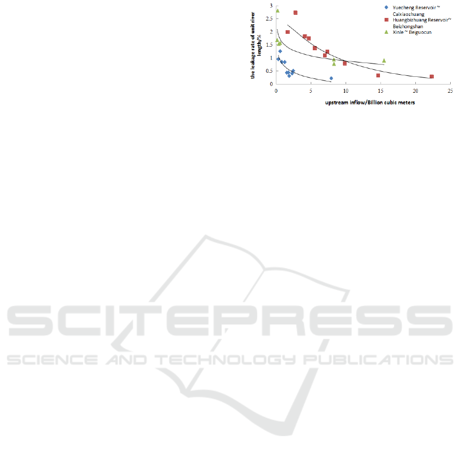
(4) The degree of river dryness is one of the main
factors affecting the seepage capacity.
The seepage capacity of the three typical reaches
is different due to the respectively underlying surface
conditions and early water storage conditions. Figure
5 shows the comparison of the leakage rate per unit
length of three typical river reaches when there is
bottomless water. Under the condition of bottomless
water, the leakage rate of unit river length in
Huangbizhuang~Beizhongshan and
Xinle~Beiguocun is obviously higher than that in
Yuecheng reservoir~Caixiaozhuang when the
upstream inflow is constant. This was mainly because
there were many floods in Yuecheng
Reservoir~Caixiaozhuang in recent 20 years, while
there were only one or two floods in the other two
typical river reaches. The dry period of the channel is
long, so the leakage capacity is large. It indicates that
the degree of river dryness is one of the main factors
affecting the seepage capacity.
Figure 5: The comparison of the leakage rate per unit length
with bottomless water.
3.2 Channel Leakage Equation
Through the optimal curve fitting, the calculation
formulas of leakage rate per unit length of three river
reaches are:
1.Yuecheng Reservoir ~ Caixiaozhuang
3.21ln( ) 0.742
u
W
bottomless water (3)
1.13ln( ) 0.195
u
W
bottom water (4)
2. Huangbizhuang Reservoir~ Beizhongshan
0.114
27.29
u
W
e
bottomless water (5)
0.51n( ) 0.198
u
W
bottom water (6)
3.Xinle ~ Beiguocun
31n( ) 1.561
u
W
bottomless water (7)
1.91n( ) 0.689
u
W
bottom water (8)
u
W
and
has the same meaning as Formula
(1).
From the above formulas, it can be seen that the
leakage rate per unit river length is generally
logarithmic or exponential related to the upstream
inflow. Bigger R
2
is regarded as the criteria of optimal
curve fitting when selecting logarithmic or
exponential equations. When the upstream inflow is
known, the leakage rate per unit river length in the
case of either bottom water or bottomless water can
be calculated by using formulas (3) ~ (8), and then the
downstream inflow can be further estimated by using
formula (1).
WRE 2021 - The International Conference on Water Resource and Environment
200
4 ESTIMATION OF INITIAL
LOSS RATE
The dry period of most rivers is long in Haihe River
Basin, so it is difficult to estimate the initial leakage
loss of the first flood in each year. Therefore, this
paper analyzed the characteristics of the initial loss
rate with different magnitude floods, to provide
reference for flood prediction and groundwater
recharge evaluation. When there is bottomless water,
the channel leakage loss includes initial seepage loss
and steady seepage loss. When there is bottom water,
the channel leakage loss is steady seepage loss. The
estimation method is as follows:
(1) Calculate the steady seepage loss rate. The
ratio of the loss of bottom water process to the
duration of flood was used as the average steady
permeability rate.
(2) Calculate the steady seepage loss. The steady
seepage loss in bottomless water process is obtained
by multiplying the average steady seepage rate by the
steady seepage duration. In recent years, local
rainstorms are frequent in Haihe River Basin, and the
runoff generation mode is mostly mixed runoff.
Therefore, the steady seepage time of bottomless
water process is approximated by the total flood
duration.
(3) Calculate the initial loss. The initial loss is
obtained by deducting the steady seepage loss from
the total loss of the bottomless water process.
(4) Calculate the initial loss rate. The initial loss
rate is the ratio of initial loss to upstream inflow.
The steady infiltration rate of Yuecheng
Reservoir~Caixiaozhuang was calculated by five
floods with bottom water since 1982, which was
0.011 million m
3
/d. The Huangbizhuang
Reservoir~Beizhongshan adopted three floods with
bottom water since 1964, and the steady infiltration
rate was 0.012 million m
3
/d. The Xinle~Beiguocun
used ten floods with bottom water since 1970, and the
steady infiltration rate was 0.007 million m
3
/d. The
calculation results of initial loss rate were shown in
Table 2~Table 4.
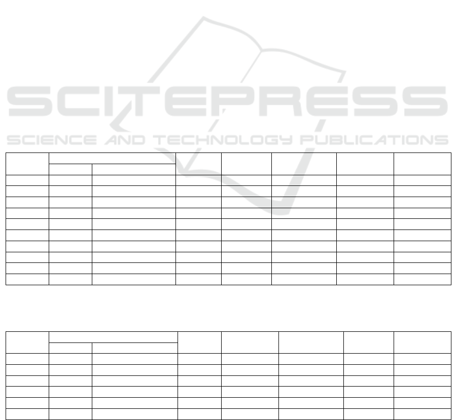
The initial loss rate of medium and small water
(upstream inflow less than 150 million m
3
) in the
Yuecheng Reservoir~Caixiaozhuang is 30%~50%,
which concentrated in 30%~40%. The initial loss rate
of large water is 10%~25%.
The initial loss rate of medium and small water
(upstream inflow less than 100 million m
3
) in
Huangbizhuang Reservoir~Beizhongshan ranges
from 50% to 80%, which concentrated in 60% to 80%.
The initial loss rate of large water is 20%~30%.
Table 2: The calculation results of initial loss rate in Yuecheng Reservoir~Caixiaozhuang.
Unit: The amount of water-billion cubic meters; Duration—day.
Number
Time
Flood
duration
Upstream
inflow
Downstream
flow
The initial
loss
The initial
loss rate/%
Yea
r
Month and Date
1 1969 6.15-7.10 26 1.54 1.11 0.15 9
2 1970 6.18-6.25 9 1.88 1.49 0.29 16
3 1988 8.11-8.17 7 1.79 1.28 0.43 24
4 1996 8.3-8.21 17 7.92 6.72 1.01 13
5 2001 7.3-7.8 6 0.33 0.16 0.10 32
6 2006 4.9-4.15 7 0.82 0.43 0.31 38
7 2008 6.2-6.20 19 1.25 0.66 0.38 30
8 2012 8.2-8.9 8 0.60 0.23 0.28 47
9 2013 7.17-8.1 16 2.31 1.70 0.43 19
10 2016 7.23-8.10 19 2.47 1.68 0.58 24
Table 3: The calculation results of initial loss rate in Huangbizhuang Reservoir~ Beizhongshan.
Unit: The amount of water-billion cubic meters; Duration-day.
Number
Time
Flood
duration
Upstream
inflow
Downstream
flow
The initial
loss
The initial
loss rate/%
Yea
r
Month and Date
1 1970 4.20-6.2 44 5.53 1.2 3.80 69
2 1971 3.15-5.30 77 7.34 1.85 4.57 62
3 1977 5.30-10.1 125 14.64 10.18 2.96 20
4 1978 9.23-10.21 29 1.65 0.18 1.12 68
5 1979 7.7-10.14 100 6.98 2.06 3.72 53
6 1991 6.29-7.24 26 4.12 0.54 3.27 79
Analysis of Channel Leakage Law in Piedmont Plain of Haihe River Basin
201
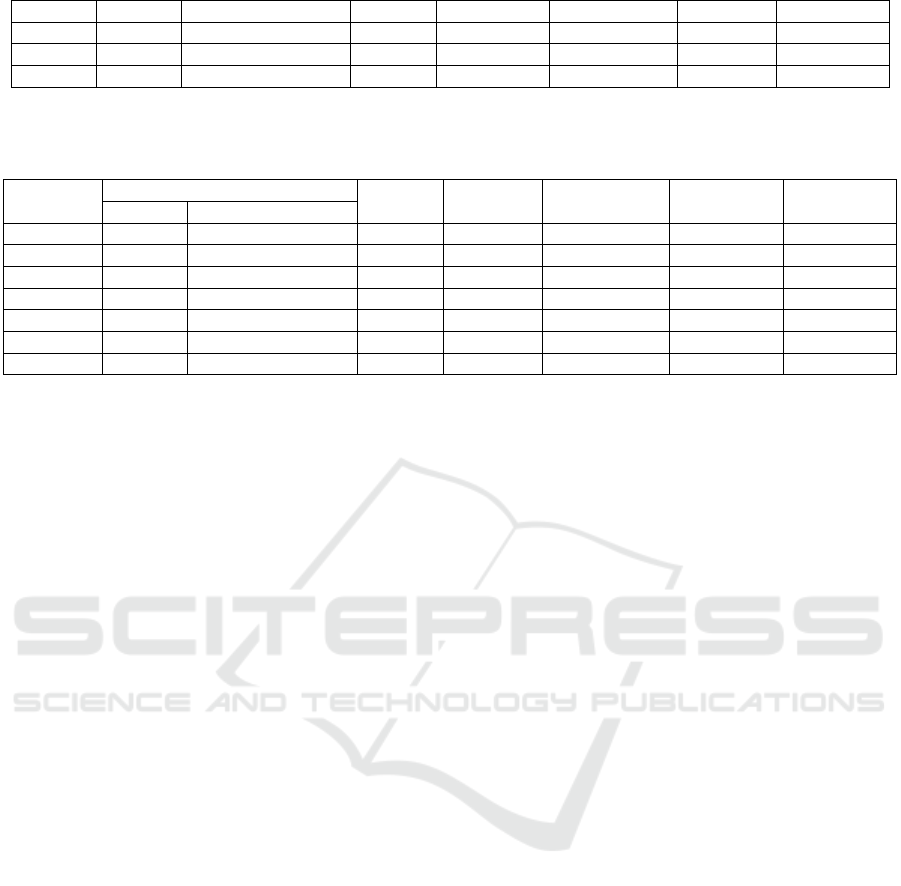
7 1996 8.3-9.2 31 22.31 16.18 5.76 26
8 1996 9.4-10.20 47 9.84 4.09 5.19 53
9 1997 4.22-5.16 25 2.76 0.13 2.33 84
10 2016 7.20-8.10 21 4.70 0.67 3.78 80
Table 4: The calculation results of initial loss rate in Xinle ~ Beiguocun.
Unit: The amount of water-billion cubic meters; Duration-day.
Number
Time
Flood
duration
Upstream
inflow
Downstream
flow
The initial
loss
The initial
loss rate/%
Yea
r
Month and Date
1 1965 7.26-8.7 13 0.17 0.07 0.08 46
2 1968 7.18-8.13 44 0.41 0.18 0.15 36
3 1978 5.25-6.16 23 15.49 9.44 6.00 38
4 1979 10.3-10.21 19 8.31 5.43 2.84 33
5 1988 8.3-9.8 33 8.29 4.94 3.29 38
6 1990 7.29-8.10 13 0.59 0.25 0.32 43
7 2013 7.11-7.19 9 0.24 0.05 0.17 53
The initial loss rate of medium and small water
(upstream inflow less than 100 million m
3
) in
Xinle~Beiguocun is 35%~55%, which concentrated
in 40%~50%. The initial loss rate of large water is
30%~40%.
The initial loss rate of medium and small water in
each reach is higher, more than 30%, and the initial
loss rate of large water is lower than that of medium
and small water. In Yuecheng~Caixiaozhuang
section, the initial loss rate of all-range water is lower
than that of the other two typical sections. The initial
loss rate of medium and small water in
Huangbizhuang reservoir~Beizhongshan is higher
than that in Xinle~Beiguocun, while that of large
water is lower than that in Xinle~Beiguocun.
5 CONCLUSIONS
In North China (Haihe River Basin as an example):
(1) The upstream inflow is negatively correlated
with the leakage rate per unit river length, and when
the upstream inflow increases to a certain value, the
leakage rate per unit river length tends to be stable; he
leakage loss rate increases along the river course.
There is a negative correlation between water
duration and leakage rate per unit river length when
there is bottom water.
(2) The dryness degree of river channel is one of
the main factors affecting the seepage capacity.
(3) The leakage rate per unit river length is
generally logarithmic or exponential related to the
upstream inflow. Through the optimal curve fitting,
the formula for calculating the leakage rate per unit
length of each typical reach is obtained by given
upstream inflow.
(4) The initial loss rate of medium and small water
in each typical reach is higher, more than 30%, and
the initial loss rate of large water is lower than that of
medium and small water.
This study has innovatively put forward the law of
channel leakage in North China (Haihe River Basin
as an example). The research results have strong
practicability and could really guide the practical
work including flood prediction, evaluation of river
recharge groundwater, etc.
ACKNOWLEDGEMENT
This work was supported by the National Key R&D
Program of China (Grant No., 2018YFE0106500).
REFERENCES
Boroughs, C. B., & Abt, S. R. (2003). Water losses along
a reach of the Pecos River in New Mexico. Journal of
the American Water Resources Association, 39(6),
1457-1464.
Grebenyukov, P. G. (2002). The Choice of Optimal Model
for Calculating Seepage Losses from Channels and
Rivers. Water Resources, 29(5), 510-517.
Lu, S. Y. (2009). Analysis of channel seepage
characteristics in piedmont plain of Hebei province.
Engineering Geology, 12(45), 115-118.
Qin, J. T. (1989). Study on channel leakage model of hebei
plain by hydrology method. Hydrogeological
Engineering, 13, 5-9.
Sun, T. W., Li, Z. X., & Qi, W. W. (2010). Analysis and
study on the law of seepage in the main stream of
Liaohe River. Technology Information, 10, 754-755.
Zhang, Y. Z., Yin, J. L., & Cui, X. D. (2002). Analysis and
WRE 2021 - The International Conference on Water Resource and Environment
202

discussion of channel leakage loss rate in central and
eastern plain area of hebei province. Groundwater,
124(1), 10-11.
Yu, H. J., Ma, J. M., & Fan, Y. Y. (2017). Research
Progress and Perspective of Simulation Methods of
River Seepage. The People's Pearl River, 38(12), 11-
15.
Analysis of Channel Leakage Law in Piedmont Plain of Haihe River Basin
203
