
A Method for Calculating the Flow and Sediment Distributions in the
Interactive Regions between the Channels and Plains of Compound
Channels
Zuwen Ji
*
and Yanxiang
Hou
State Key Laboratory of Simulation and Regulation of River Basin Water Cycle, China Institute of Water Resources and
Hydropower Research, Beijing, China, 100048
Keywords: Compound channels, Flow velocities, Sediment concentrations, Main channels, Flood plains
Abstract: In the present study, on the basis of the generalized experimental data of compound channels, and the regional
characteristics of flow and sediment movements, four regions were proposed according to the compound
sections of channels and plains. These included the undisturbed regions in the main channels; interactive
regions between the channels and the plains; undisturbed regions in the floodplains; and the boundary regions.
The interactive regions between the channels and plains, which were characterized by the most complicated
water flow regimes, were further divided into logarithmic flow velocity zones (inner zones) and non-
logarithmic flow velocity zones (outer zones). Then, by introducing an S-shaped curve, a method for
determining the boundary between the inner zones and outer zones was proposed. The water-sediment
exchange intensity in the interactive region is higher than that in other areas, so it is a key point in the study
of compound channel.
1 INTRODUCTION
Compound channels, which have obvious flood
plains and main channels in their sectional
morphology, are the most common pattern of
manifestation of alluvial rivers. In China, the lower
reaches of the Yellow River have the characteristics
of a typical compound channel. The main stream is
approximately 880 km in length and begins in
Mengjin County. The channel is mainly composed of
flood plains and a main channel. The flood plain area
is approximately 3,500 km
2
and accounts for 84% of
the total channel area (Hu et al., 2012). Under natural
conditions, due to the alluvial characteristics of the
channel, it has been observed that although the
compound channel maintains the pattern of channel
and plains areas in the section morphology, the
location of its main channel often moves. These
movements are often shown as swings of the channel
onto the plains. This type of swinging action not only
directly threatens the safety of the channel’s
regulation works, such as flood control dykes, but
also brings adverse effects to such industrial and
agricultural production processes as intake and
drainage utilities, flood plain utilization processes,
and so on (Zhang, 2017).
It has been accepted that the determination of the
laws of flow and sediment movements in compound
channels are very important problems in current
engineering practices. Also, the results of such studies
would be of great value in the theoretical
development of river dynamics. The theoretical
studies of flood plain flow structures can potentially
promote the development of river dynamics and lay
foundations for the study of the laws of flow and
sediment movements in compound channels. At the
present time, there are abundant research results
available regarding the characteristics of clear water
flow in channel-plain compound channels. These
studies have mainly included the flow capacities of
compound channels and the resistance characteristics
of channels and plains (Hang, 2016; Rhodes & Knight,
1994), as well as the flow structures and turbulence
intensities of channels and plains (Shiono & Knight,
1991; Tominaga & Nezu, 1991), flow velocities,
distribution characteristics of flood plains (Tominaga
& Nezu, 1991; Hu et al., 2010), and so on. Previously,
many research achievements were made in the study
of muddy water flow, which have mainly included the
134
Ji, Z. and Hou, Y.
A Method for Calculating the Flow and Sediment Distributions in the Interactive Regions between the Channels and Plains of Compound Channels.
In Proceedings of the 7th International Conference on Water Resource and Environment (WRE 2021), pages 134-139
ISBN: 978-989-758-560-9; ISSN: 1755-1315
Copyright
c
2022 by SCITEPRESS – Science and Technology Publications, Lda. All rights reserved
sediment concentrations and distribution
characteristics of channels and plains (Hu et al., 2010;
Edmonds et al., 2017; Armugha et al., 2018), and the
sediment accumulations and distributions in channels
and plains of natural channels (Liu et al., 2016; Chen
et al., 1996; Ji et al., 2019). However, it was found
that in the existing study results, there have been only
a few studies conducted regarding the regional
characteristics of the sediment and water distributions
in the channels and plains of compound channels.
Therefore, based on the experimental data and
existing research results (Walling et al., 2015; Min et
al., 2017), this study focused on the interactive
regions of channels and plains, and proposed a
method of determining the boundaries between the
inner and outer zones, which would provide technical
support and theoretical guidance for the planning and
management of the plain areas of compound
channels.
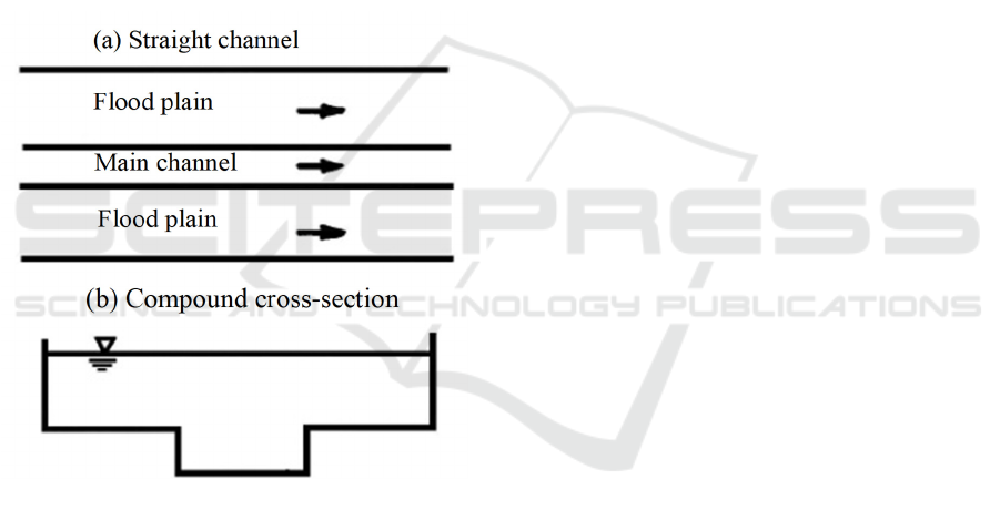
Figure 1: Structural form of the compound channel.
2 BASIC SITUATION OF THE
EXPERIMENTAL AREA
In a previous related study, the author performed a
large number of experiments regarding the
distributions of flow and sediment in the channel and
plain areas within a 30 m long self-circulating
channel (Hu et al., 2010; Ji et al., 2019). The self-
circulating plain consisted of a straight channel and
wide-narrow alternating channels, and its sections
were mainly rectangular sections. The beds of the
channel and plain areas had a height difference of
0.06, and the bed and side wall of the channel were
cement surfaces. The channel structure is shown in
Figure 1. In the experiment, sections were compound
rectangular sections, with the same widths as the main
channel and height differences from the channel and
plain areas.
During the experiment, the experimental water
depths had ranged between 0.03 and 0.13 m, and the
sediment concentrations had ranged from 4 to 83
kg/m
3
. Fly ash was used in the experiment as the
experimental model sand. The median particle sizes
of the experimental model sand ranged between 0.014
and 0.056 mm; the specific gravity was 2,100 kg/m
3
;
and the non-uniformity coefficient was between 1.73
and 2.12.
3 REGIONAL HARACTERISTICS
OF COMPOUND CHANNEL
Due to the height differences in the beds of the
different channels and plains of the compound
channel, the momentum transfers among the channel
and plain flows tended to be obvious. The flow
energy losses at the boundary areas of the channels
and plains were found to be larger, and the flow
capacities of compound channels had become
obviously smaller than those of single rectangular
channels of the same scale. According to the existing
research results, the distributions of the flow and
sediment in channels and plains had the following
characteristics:
(1) From the average flow velocities of the
channel and plain sections, it could be seen that the
average velocities of the main channels and the entire
sections of the compound channels first increased,
then decreased, and then increased once again with
the increases in the water depths. Meanwhile, the
average velocities of the plain areas tended to
increase monotonously with the increases in the water
depths. The average sediment concentrations of the
plain areas were less than the average sediment
concentrations of the main channels. The ratios of the
average sediment concentrations of the channel and
plain areas had increased with the increases in the
relative water depths of the channels and plains (Hu
et al., 2010).
(2) It could be seen from the average velocities in
the vertical direction that the lateral variations of the
velocity gradients near the boundaries between the
channels and the plains in compound channels tended
to be large. Also, water flow exchanges characterized
by strong momentum were observed between the
main channels and the plains. The peak values of the
A Method for Calculating the Flow and Sediment Distributions in the Interactive Regions between the Channels and Plains of Compound
Channels
135

momentum exchanges between the channels and the
plains had generally appeared near the boundaries
between the channels and the plains, and then had
gradually decreased toward both sides (Shiono et al.,
1991). It was found that when the channel and plain
areas were sufficiently wide, areas had existed where
the lateral velocity gradients tended to remain
constant in both the main channels and the plains. In
those areas, the flow had basically not been affected
by the momentum exchanges between the channels
and the plains. Moreover, interactive zones of the
channel and plain areas were evident between the two
regions, in which the lateral gradients of the flow
velocities had changed greatly, and the flow
movements had strong three-dimensional
characteristics. Correspondingly, the vertical mean
gradients of the sediment concentrations had tended
to gradually increase from the vicinities of the
boundaries between the channels and plains to both
sides of the channels and plains. The vertical
heterogeneity of the sediment concentrations in the
plain areas was found to be much greater than that of
the main channels, which had been observed to reach
minimal values near the boundaries of the channels
and plains, and then gradually increase toward both
sides of the channels and plains (Hu et al., 2010; Chen
et al., 1996).
(3) From the perspective of the vertical
distributions, the vertical velocity distributions of the
water flow far away from the boundaries of the
channels and plains and the boundary wall areas were
less deformed. However, in the areas near the
boundaries of the channels and plains, the vertical
velocity distributions tended to be more deformed.
The maximum velocities of the vertical velocity
distributions on one side of the main channel were
observed to be no longer at the surface of the water,
but at certain depth levels below the water surface. On
one side of the plain, the water velocities had
gradually increased from the bottom to the surface,
with the maximum velocities still observed on the
water surface. In addition, the vertical velocities at
certain depths from the bed surfaces had still obeyed
the logarithmic distributions. However, outside of
those ranges, the vertical velocities had tended to
deviate from the logarithmic distributions, and the
measured values on one side of main channel was
consistently smaller than the calculated value of
logarithmic formula. Also, the measured values on
the plain side was consistently larger than the
calculated value of formula. However, in the
transverse direction, the differences between the
measured values and calculated values of the flow
velocities had reached the maximums at the
boundaries of the channels and plains, and those
differences had then gradually decreased toward one
side of the main channel or plain. In the vertical
direction, the difference between the measured values
and the calculated values was zero at a certain water
depth from the bed surface and had gradually
increased in an upward direction to reach the
maximum near the water surface (Hu et al., 2010).
Therefore, from the aforementioned research
results regarding the flow and sediment movements
in a compound channel, it could be ascertained that
obvious regional characteristics had existed in the
sectional distributions.
4 DETERMINATIONS OF THE
INTERACTIVE ZONES IN
COMPOUND CHANNEL
4.1 Zoning of the Compound Sections
in Compound Channel
In the current study, in accordance with the
movement characteristics of the flow in the channels
and plains of a compound channel, a cross-section of
the flow of the compound channel was divided into
four regions as follows: 1. An undisturbed region of
the main channel (Region I); interactive region
between the channels and plains (Region II);
undisturbed region in the floodplains (Region III);
and a boundary region (Region IV), as detailed in
Figure 2. Moreover, the formula (Hu et al., 2010)
which was used for calculating the width of each
region is also presented in Figure 2. In the formula, h
d
represents the bed height differences of the channels
and plains; b
mo
is the width at one side of main
channel in the interactive zone of the channels and
plains; b
fo
is the width at one side of plain in the
interactive zone of the channels and plains; Z
I-II
indicates the transverse coordinates of the boundary
of the undisturbed region in the main channel and the
interactive region between the channels and plains;
Z
II-III
is the transverse coordinates of the boundary of
the interactive region between the channel and plain
areas and the undisturbed region in the flood plain;
and Z
III-IV
indicates the transverse coordinates at the
boundary between the undisturbed region in the flood
plain and the boundary region.
In view of the regional characteristics of the flow
and sediment distributions in compound channels,
especially in the most critical interactive zones
between the channels and plains (Walling et al.,
2015), the interactive zone between the channels and
WRE 2021 - The International Conference on Water Resource and Environment
136
plains was further divided into a logarithmic velocity
zone (inner zone) and a non-logarithmic velocity zone
(outer zone). The boundary of those zones is indicated
by αH in Figure 3.
Figure 2: Schematic diagram for the sectional zoning of a
compound channel.
Figure 3: Schematic diagram for the velocity zoning in the
interactive zone between the channels and the plains of a
compound channel.
4.2 Determination of the Boundary
between the Inner and Outer Zones
in the Interactive Regions
In the present study, from the characteristics of the
vertical velocity distributions of the water flow, it
could be seen that the boundary between the inner and
outer zones of the channel-plain interaction zone was
basically an "S" type distribution (Walling et al.,
2015) in the main channel and plain areas. For that
reason, an S-type curve was introduced for the
purpose of demonstrating the boundary between the
inner and outer zones of the channel-plain interaction
zone (Hu et al., 2010; Liu et al., 2016; Chen et al.,
1996; Ji et al., 2019). The formula (Wang & Guo,
1979) was as follows:
M/(1+Nexp(-Cz))y =
(1
)
Where M, N, and C are the undetermined
coefficients larger than 0, when z = 0 and y =
M/(1+N); and when it tends to be ∞, y = M. In order
to facilitate the analysis process, the coordinate
system was required to be appropriately transformed.
The origin of the coordinate system was shifted from
the middle position O of the main channel bed (Figure
2) to the peak O’ of the boundary of the channel and
plain areas (Figure 3). The coordinate variables were
then accordingly transformed from y and z to y' and
z'. After the coordinate system transformation was
completed, the curve fitting was carried out according
to the measured data of the main channel and plains,
respectively. Then, for any three observational values
(z1, y1), (z2, y2), and (z3, y3), the simultaneous
equations were obtained by substituting Formula (1),
respectively, and the following formula was obtained
by setting z2 = (z1+z3)/2:
()()
22
21 3 123 2 13
()
M
yy y yyy y yy=+− −2
(2
)
After the estimated value of M was obtained,
Formula (1) was transposed and the following
formula was obtained after taking the natural
logarithm:
()
ln( ) ln
M
yy NCz−=−
(3
)
Then, if was set, Formula (3) could be
transformed to a linear formula as follows:
lnyNCz=−
(4
)
Therefore, the conformity of y and z to the
logistical equation (Zwillinger, 1997) can be obtained
by the correlation coefficient of and z:
z
yz yz y
SP SS SS
γ
=⋅
(5
)
The regression statistics N and C can then be
calculated using the following formula:
/
x
yx
CSPSS−=
exp( )NyCx=+
(6
)
Then, according to the above-mentioned linear
processing method, the data at the turning point of
one side of main channel at the boundary of Z
I-II
and
O', as well as at the boundary between the inner zone
and outer zone; or the data at the turning point at one
side of plain at the boundary O' and Z
II-III
, as well as
the boundary between the inner zone and outer zone,
respectively, which could be substituted into
(IV) (II I)
(II) (I)
ZI- I I
ZII-III
ZIII-IV
b
I
b
II
b
II I
b
mo
b
fo
b
b
h
fp
h
mc
h
d
bmc
bfp
B
z
y
x
o
A Method for Calculating the Flow and Sediment Distributions in the Interactive Regions between the Channels and Plains of Compound
Channels
137
Formulas (2) and (6), for the purpose of fitting and
calculating the M, N and C values. Therefore, the
formula for the calculation of the boundary between
the inner and outer zones of the interactive region of
the channel and plain areas could be successfully
obtained as follows:
For the main channel:
()
()
' 1.0046 1 99.4571exp 9.9877 '
fp mo
yH zb=+
'0
mo
bz−≤≤
(7
)
For the plain areas:
()
()
' 1.0104 1 100.04171exp 9.1699 '
fp fo
yH zb=+ −
0'
fo
zb≤≤
(8)
Where b
mo
and bmo represent the widths at one
side of main channel and plain in the interactive zone
of the channels and plains, respectively; H
fp
is the
water depths of the plain areas; and y' and z' are the
vertical and lateral coordinates with the boundary
between the channels and plains as the center of the
circle. The fitting results of boundary of the
interactive zone between the main channels and
plains in the interactive zone of the channel and plain
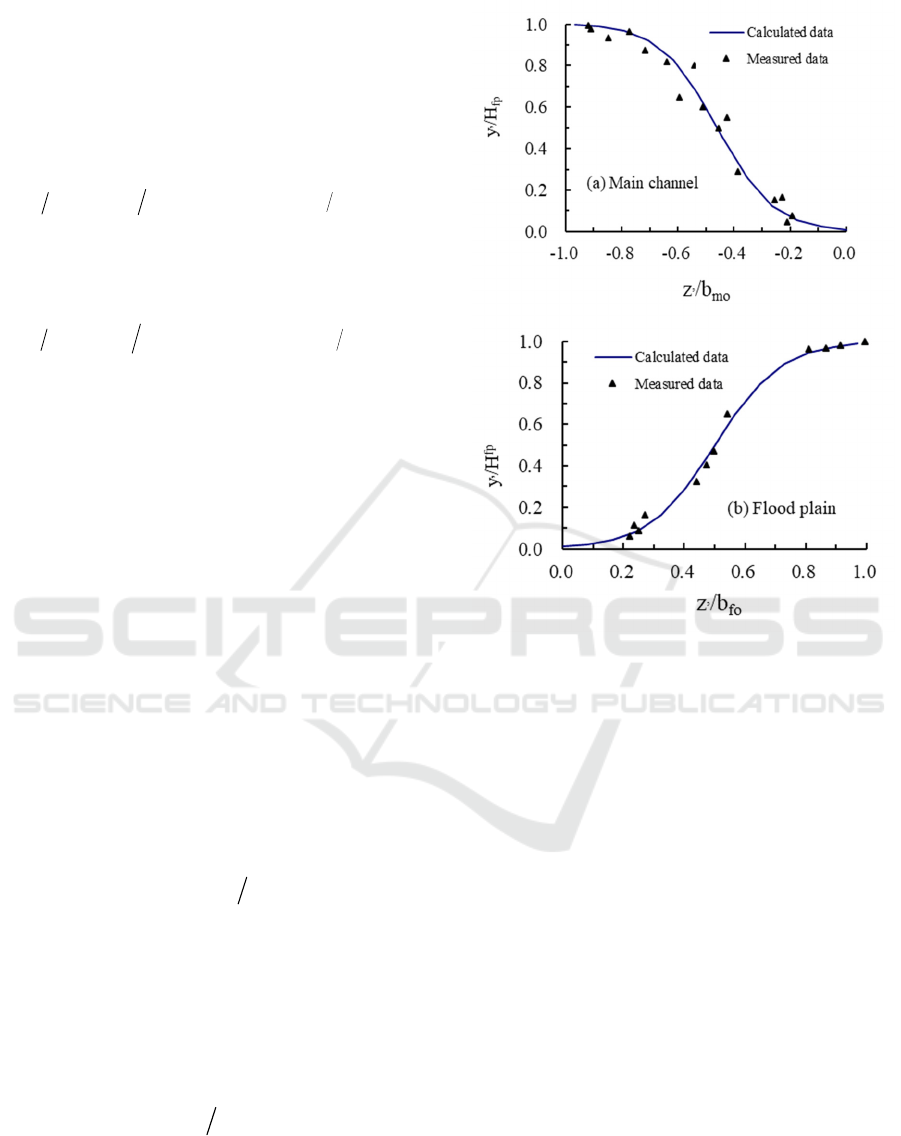
areas are shown in Figure 4.
In combination with the results detailed in Figures
2 and 3, it could be seen that αH represented the
distance from the boundary between the inner and
outer zones of the channel and plain areas interactive
zone to the bed surface of the channel. As detailed in
the figures, one side of the main channel was
represented by αH = h
d
+y', and so on. The sizes of the
boundary values of the inner and outer zones could
then be expressed using the following formula:
()
'
mc d mc
yh H
α
=+
'0
mo
bz−≤≤
(9
)
Where H
mc
indicates the water depth in the main
channel and is y' in the calculation results of Formula
(7). For the plain areas, the sizes of the values of
boundary between the inner and outer zones could be
calculated using the following formula:
'
fp fp
yH
α
=
0'
fo
zb≤≤
(10)
Where y' is calculated according to Formula (8).
Figure 4: Comparisons between the calculated and
measured values of the boundary between the inner and
outer zones of the interactive zone of the channel and plain
areas.
5 CONCLUSIONS
The flow and sediment movements of the channels
and plains in the examined compound channel had
displayed obvious regional characteristics. Therefore,
in accordance with those observed characteristics, the
compound sections of the channels and plains could
be divided into the following: An undisturbed region
in the main channel; interactive region of the channels
and plains; undisturbed region in the flood plain; and
the boundary wall region. The interactive region of
the channels and plains which had best reflected the
flow and sediment distribution characteristics of the
channels and plains included the logarithmic velocity
zone (inner zone) and the non-logarithmic velocity
zone (outer zone). It was found that the vertical
distributions of the water flow in the inner zone had
followed the logarithmic velocity formula. Also, the
velocity of water flow on the side of the main channel
in the outer zone was observed to be lower than the
WRE 2021 - The International Conference on Water Resource and Environment
138

calculation results of the logarithmic formula, while
that on the side of the plain area was found to be larger
than the calculation results of the logarithmic
formula. Therefore, based on these findings, the
boundary between the inner zone and the outer zone
had been successfully determined in this study. Then,
by introducing an S-shaped curve, the calculation
formula of the boundary was deduced, which
provided a clear basis for the control and management
of the channel and plain areas.
This study’s analysis results of the different zones
indicated that the interactive zone of the channels and
plains should be considered as the key point for the
regulation and management of a compound channel.
ACKNOWLEDGEMENTS
It was supported by the National natural science
foundation of China(grant No. 51879282) and the
National Key Research and Development Program of
China (grant No.2017YFC0405501) and Technology
Project of Power China (grant No. DJ-PTZX-2019-
05) and the Open Research Fund of State Key
Laboratory of Simulation and Regulation of Water
Cycle in River Basin, China Institute of Water
Resources and Hydropower Research(grant No.
SKL2018ZY07).
REFERENCES
Armugha, K., Liaqat, A. K. R., Ali, P. Y., & Himanshu, G.
(2018). Characterization of channel planform features
and sinuosity indices in parts of Yamuna River flood
plain using remote sensing and GIS techniques.
Arabian Journal of Geosciences, 11(17), 1-11.
Chen, L. Zheng, Y. Z., & Zhou, Y. L. (1996). Commutative
form and function between water and sediment of silt
laden flow in compound channel. Journal of Sediment
Research, 1996(2), 45-49.
Edmonds, D. A., Moron, S., & Amos, K. (2017). The role
of floodplain width and alluvial bar growth as a
precursor for the formation of anabranching rivers.
Geomorphology, 278(1), 78-90.
Hu, C. H., Chen, J. G., and Guo, Q. C. (2012). Shaping and
maintaining a medium-sized main channel in the Lower
Yellow River. International Journal of Sediment
Research, 27(3), 259–270.
Hang, Y. F. (2016). Impact on composite roughness by
cross-section morphology of compound channel. Port
and Waterway Engineering, 2016(8), 94-98.
Hu, C. H., & Ji Z. W., & Guo, Q. C. (2010). Flow
movement and sediment transport in compound
channels. Journal of Hydraulic Research, 48(1), 23-32.
Ji, Z. W., Hu, C. H., & Zhao, X. (2019). Characteristics of
water and sediment distribution in the lotus-root-shape
compound channels. Proceedings of the 38TH IAHR
World Congress-IAHR (Panama), 307-314.
Liu, C., Shan, Y. Q., Liu, X. N.,Yang, K. J., & Liao, H. S.
(2016). The effect of floodplain grass on the flow
characteristics of meandering compound channels.
Journal of Hydrology, 542, 1-17.
Min, Z., He, Q. H., Carling, P. A., & Zhang, M. W. (2017).
Sedimentation of overbank floods in the confined
complex channel–floodplain system of the Lower
Yellow River. Hydrological Processes, 31(20), 3472–
3488.
Rhodes, D. G., & Knight, D. W. (1994). Velocity and
boundary shear in a wide compound duct. Journal of
Hydraulic Research, 1994(5), 743-764.
Shiono, K., & Knight, D. W. (1991). Turbulent open-
channel flows with variable depth across the channel.
Journal of Fluid Mechanics, 222(1), 617-646.
Tominaga, A., & Nezu, L. (1991). Turbulent structure in
compound open-channel flow. Journal of Hydraulic
Engineering, 117(1), 21-41.
Walling, D. E., Owens, P. N., & Leeks, G. J. L. (2015).
Rates of contemporary overbank sedimentation and
sediment storage on the floodplains of the main channel
systems of the Yorkshire Ouse and River. Tweed
Hydrological Processes, 13(7), 993-1009.
Wang, Z. X., & Guo, D. R. (1979).
Introduction to Special
Functions. Beijing: Science Press.
Zwillinger, D. (1997). Handbook of Differential Equations.
New York: Acdemic Press.
Zhang, J. L. (2017). Reconstruction and Ecological
Management of the Lower Yellow River. Floodplain
Yellow River, 39(6), 24-27.
A Method for Calculating the Flow and Sediment Distributions in the Interactive Regions between the Channels and Plains of Compound
Channels
139
