
Landscapes in the Horqin Sandy Land: Patterns and Processes
Chunwei Song
*
, Shihui Wang and Weiyi Lu
College of Tourism and Geographical Sciences, Jilin Normal University, Siping, Jilin, China
Keywords: Sand dune pattern, Landscape evolution, Lake complex, Horqin Sandy Land
Abstract: The Horqin Sandy Land (HSL) falls in the interlocking agricultural and pastoral zones in northern China.
The sandy area experiences wind and water erosion and the evolution of lakes and landcover is closely
related to changes to the sandy land surface. This study applied geomorphological analysis and
mathematical and statistical analyses to multiple sources of remote sensing data to study the characteristics
and changes in landforms, lakes, and lan cover patterns in the area. The results showed that the area of
sandy land in the HSL has decreased over the last 40 years at an average rate of -0.31%, whereas the areas
of fixed and semi-fixed sand dunes, such as scrub dunes and parabolic dunes, are increasing. The area of
lakes and the number of patches have decreased, there was increased clustering of lakes, and the changes to
the landscape appear to be stabilizing. There was an increase in vegetation growth, with mean annual
average Normalized Difference Vegetation Index (NDVI) of between 1.42–2.06. There was an obvious
increase in NDVI, mainly in the southeastern part of the study area. The study provides a basis for the
sustainable development of the ecological environment in the HSL.
1 INTRODUCTION
Landscape evolution is an important field in
geography and ecology and refers to changes in the
structure and function of land surface processes at
various spatial and temporal scales driven by natural
and human factors (Wu, 2013; Elhag, 2017; Fan et
al., 2018). The use of remote sensing data sources
and geographic information system (GIS) spatial
analysis methods within the study of landscape
evolution can reveal the processes and patterns of
land surface evolution, which is of importance in
regional sustainable development. Many past studies
have focused on the dynamic changes in sandy land
at different spatial and temporal scales and using
different landscape classification systems (Zuo et al.,
2009; Li et al., 2008; Wu and Ci, 2001). Among
current processes driving the evolution of sandy
land, lakes play an important role in maintaining the
wind-water balance and wetland landscape ecology
(Gao et al., 2020; Zhao and Feng, 2020; Zhu et al.,
2010). Consequently, there have been studies in
China and abroad on lakes in sandy land areas,
mostly focusing on lake area dynamics, hydrological
characteristics, and the impact of climate change.
For example, a study by Bai et al. on changes to the
lake area in the Otindag Sandy Land area over the
past 45 years determined that lake shrinkage was
mostly concentrated in the sandy hinterland (Bai et
al., 2016). Dong et al. explored the underlying
mechanism of recharge of the Alashan Desert Lake
Group (Dong et al., 2016). Past studies have gained
some understanding on the coupling relationship
between wind-sand activities and vegetation
conditions, including on changes to vegetation
cover, the movement of sand grains, wind erosion
speed, and wind profile height (El-Wahab et al.,
2018; Zhang, 2012). However, there has been
relatively less focus on the relationship between the
changes in and interactions between these three
landscapes (Chen et al., 2006). Past studies on the
wind- and sand-driven landscapes in the HSL have
mostly focused on the spatial and temporal changes
to the sandy area, assessment of the degree of
desertification, the evolution of landscape patterns,
and drivers of landscape change (Li et al., 2017; Bai
et al., 2017; Duan et al., 2012; Duan et al., 2014).
Past studies of lakes in sandy areas have mostly
focused on the dynamic changes in lake numbers
and their influences on climate (Chang et al., 2013;
Jia et al., 2014). However, studies on the interactions
between sandy areas and vegetation and between
sandy areas lake based on long timeseries data
remain limited. Therefore, the current study
Song, C., Wang, S. and Lu, W.
Landscapes in the Horqin Sandy Land: Patterns and Processes.
In Proceedings of the 7th International Conference on Water Resource and Environment (WRE 2021), pages 123-127
ISBN: 978-989-758-560-9; ISSN: 1755-1315
Copyright
c
2022 by SCITEPRESS – Science and Technology Publications, Lda. All rights reserved
123

conducted long-term remote sensing monitoring of
the sandy land and lake group dynamics of the HSL
based on multiple sources of satellite data. The aim
of the present study was to identify the
characteristics of the evolution of sandy land, lake
and landcover patterns in this area over the last 40
years to explore the relationships between sandy
patterns and lake and vegetation. The results of the
present study can provide a scientific basis for the
study of regional landscape responses in the context
of global environmental change.
2 OVERVIEW OF THE STUDY
AREA AND RESEARCH
METHODS
2.1 Overview of the Study Area
The HSL is located at the edge of the monsoon zone
and is a typical agro-pastoral area in northern China.
The distribution area of HSL is about 42.3 thousand
square kilometers and falls between 118°31′–
124°18′ E, 42°31′–44°50′N. The climate of the
region is characterized by a transition from the warm
temperate zone to the temperate zone and semi-
humid zone to semi-arid zone. The frost-free period
of the area is 140–160 d, the annual average
temperature is 5.2–6.4 °C, annual precipitation is
343–500 mm, annual sunshine hours are 2 900–3
100 h. The zonal soil is mainly dark brown loam,
chestnut calcium soil, and black kiln soil, whereas
the non-zonal soil is mainly sandy soil, meadow soil,
and saline-alkaline soil. The zonal vegetation
transitions from typical grassland to forest grassland.
The HSL contains sand dunes, inter-dune
depressions, and swamp bubbles. Several sand
monopolies and inter-monopoly depressions occur
from the rear banner of the left wing of the HSL to
the Changling. The inter-monopoly depressions are
distributed with ancient riverbeds, lakes or deans
running from east to west.
2.2 Data Source and Pre-processing
The multispectral remote sensing data used in the
present study included Landsat Multi-Spectral
Scanner (MSS) multispectral images (spatial
resolution of 80 m) for 1980, Landsat Thematic
Mapper (TM) multispectral images (spatial
resolution of 30 m) for 1990, 2000, 2010, and 2020,
Landsat Operational Land Imager (OLI)
multispectral images (spatial resolution of 30 m).
The topographic map and coordinates of typical
features measured by a real-time kinematic global
positioning system were used as control points to
geometrically finetune the data for each synthesis
band, and the error was minimized to within one
pixel. Histogram matching and stitching were
performed on the contemporaneous data, following
which the images were cropped according to the
boundary of the study area. The wind-driven sandy
land types were divided into nine categories: (1)
wind erosion pits; (2) scrub dunes; (3) gently
undulating dunes; (4) beam-well dunes; (5)
parabolic dunes; (6) flat dunes; (7) sand monopolies;
(8) crescent-shaped dunes and; (9) dune chains.
Lakes were divided into several categories,
including natural lakes, artificial reservoirs, and
ponds.
2.3 Research Methodology
2.3.1 Interpretation of Remote Sensing
Image Data
Manual visual interpretation for object-oriented
segmentation was used to improve the accuracy of
classification. GPS-guided field observation was
conducted to interpret areas not yet defined, and the
interpretation was verified using the random point
method with an accuracy of 91.02%.
2.3.2 Maximum Value Synthesis Method
The Maximum Value Composites (MVC) were used
to obtain the maximum monthly NDVI for the
analysis of regional vegetation cover and
spatiotemporal characteristics of NDVI variation.
The vegetation index reflects a certain period of time
within the remote sensing data under an optimal
state for interpretation, which can effectively reduce
errors resulting from aerosols, cloud shadows, and
perspective, thereby improving the precision of the
vegetation index.
2.3.3 Mean Value Method
The present study adopted the mean value method
(MVM) to statistically analyze the mean value of
NDVI in the study area. The MVM is an index
reflecting the central trend of a dataset and is used to
calculate the mean NDVI of vegetation in the study
area over a certain period. The MVM can reduce
disturbance from outliers resulting from the angle of
solar altitude and extreme climate conditions,
thereby improving the accuracy of the vegetation
index.
WRE 2021 - The International Conference on Water Resource and Environment
124
3 RESULTS AND ANALYSIS
3.1 Evolution of Sandy Land in the
HSL
The wind-driven sandy land in the HSL is mainly
distributed on the alluvial plains along the dry
tributary streams of the Xiliao River. The sand dune
types of the Horqin Sand Area tend to become
simpler from west to east and from south to north.
The area of wind-driven sandy land has been
decreasing continuously over the last 40 years, with
a net decrease in the sand area of 5,194.33 km
2
and
an annual rate of change of −0.31%. There were
general increases in the areas of crescent-shaped
dunes and dune chains from 1980 to 2020, with a net
increase in area of 165.51 km
2
. There was an
average annual growth rate in the areas of crescent-
shaped dunes and dune chains of 1.47% from 1980
to 2000, followed by a declining trend from 2000 to
2020 with an average annual rate of change of
−1.17%. The area of scrub dunes showing
fluctuating increases, with a total increase in area of
331.53 km
2
, with most of the increases occurring
over the last 10 years at a growth rate of 0.37%. The
area of beam nest dunes continued to decrease, with
a net decrease of 5,194.43 km
2
. The area of flat
sandy land fluctuated, although there was a rapid
decreasing trend in the area of flat sandy land over
the last 10 years. The area of parabolic dunes
showed a fluctuating increasing trend. The areas of
gently undulating sandy land and sandy monopoly
land both showed fluctuating decreasing trends, with
net decreases of 6.35% and 11.28%, respectively.
The area of wind erosion pits did not change
significantly. In general, the area of the wind-driven
sandy land of HSL decreased over the last 40 years,
while the area of fixed and semi-fixed dunes such as
scrub dune land and parabolic dunes increased,
indicating that the mobility of the Horqin Sand Area
weakened and showed a trend of moving from
desertification to oasis.
3.2 Evolution of the Lake
The overall area of lake Complex showed a
decreasing trend over the last 40 years. The area
increased by 239.87 km
2
from 1980 to 1990, with an
annual rate of change of 3.91%. The area began to
decrease from 1990, decreasing by 6.78 km
2
by
2000. The area decreased by 247.99 km
2
from 2000
to 2010, with an annual rate of change of −3.8%.
The decreasing trend in the lakes complex gradually
stabilized from 2010 to 2020, with an annual rate of
change of −2.90%. The number of patches of lake
groups showed a continuous increasing trend from
1980 to 2000, with a total increase of 314. The
increasing trend was most significant from 1980 to
1990, with an annual rate of change of 6.62% and
reaching a maximum value of 623 in 2000.
However, the change in number of patches of lake
groups was not synchronized with the change in lake
area, indicating increased fragmentation of the lake
during this period. The change in the number of
lakes from 2000 to 2020 was consistent with the
change in area, showing a rapid decline with an
annual rate of change of −4.60%.
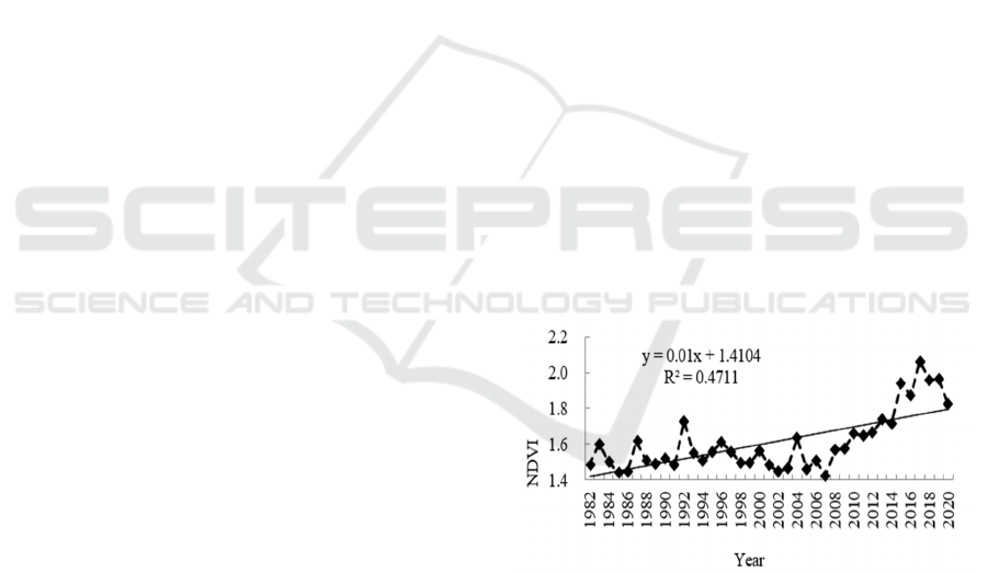
3.3 Evolution of the Vegetation
Landscape
The overall NDVI trend in the HSL during the
growing season from 1982 to 2020 was one of
fluctuating increase, with an increase in area of
23.05% and an average annual growth rate of 0.59%
(Figure 1). NDVI showed a fluctuating increasing
trend from 1982 to 1992, with an increase of 16.43%
and an average annual rate of increase of 1.64%.
NDVI showed a fluctuating decreasing trend from
1992 to 2007, with a decrease of 17.46% and an
average annual rate of decrease of 1.16%. A
significant increasing trend in NDVI was evident
from 2007 to 2020, with an increase of 28.31% and
an average annual rate of increase of 2.18%. NDVI
reached a maximum in 2017 of 2.0639.
Figure 1: Interannual trends of NDVI in HSL.
The NDVI during the vegetation growing season
decreased from east to west, with an annual average
exceeding 0.25 in most areas over the last 39 years
and good vegetation conditions. The annual average
NDVI in the southwestern part of the sandy area
ranged from 0.15 to 0.25, and vegetation conditions
were slightly worse. The multi-year mean NDVIs
for Shuangliao City, Kangping County, and
southeastern Horqin Left Wing Back Banner were
high, ranging from 0.35 to 0.49, whereas the multi-
year mean NDVI for Wengniut Banner and western
Landscapes in the Horqin Sandy Land: Patterns and Processes
125

Naiman Banner were relatively low, ranging from
0.15 to 0.26.
4 DISCUSSION
The changes to HSL over the last 40 years were
characterized by a decrease in the total area of the
wind-driven sandy landscape and an increase in
fixed and semi-fixed sand dunes, such as scrub
dunes. These changes are consistent with a transition
from desert toward oasis and are supported by the
findings of Yue et al. (Yue et al., 2017). Lake
complexes in sandy areas are important components
of desert ecosystems and play an important role in
maintaining ecological stability and development
(Ma et al., 2016). However, lake complexes
themselves have poor stability, and the areas and
numbers of lake complexes vary greatly on
interannual and seasonal scales due to the influences
of climate and human activities (Duan et al., 2012).
The HSL is in a dynamic equilibrium, which
maintains its developmental stability under the
interactions of wind and water erosion. Moisture is
the most dominant factor governing plant growth
and survival. Improved moisture conditions and lush
vegetation growth around the lake complex have an
important influence on the structure of the regional
sand flow field and wind-driven sand transport,
which in turn determines the evolution of the sandy
landscape within a certain buffer zone around the
lake complex (Smith et al., 2017; Bai et al., 2016).
However, such areas are also mostly surrounded by
lakes and fields, resulting in the transformation from
natural to artificial landscapes and in the shrinkage
of the lake area. In addition, the construction of
reservoirs in the upper reaches of rivers, inevitably
affect downstream runoff and change the water and
sand conditions of rivers. A reduction in river flow
can result in the river running dry and the exposure
of rocks on the riverbed. These rocks can act as
sources of sand for the development of riverbank
dunes (Liu and Coulthard; 2015). A decrease in
surface water results in a decrease in the water table.
The water table in lumps and sand swamps will also
decrease, resulting in decreases in moisture-loving
plants, the establishment of drought-tolerant plants,
the death of trees, lower vegetation cover, dune
activation, and the continued expansion of
desertification (Telfer et al., 2017). The processes
driving the evolution of both landforms and
landscape patterns can be represented by spatial
attribute information.
The overall trend of a fluctuating increase in
NDVI in the HSL during the vegetation growing
season is consistent with the results of studies on
NDVI trends at different scales, such as in eastern
China (Liu et al., 2015; Han, 2007). In particular,
NDVI showed significant increasing and decreasing
trends before and after 1992, respectively, generally
consistent with the findings of Piao et al. for the
Eurasian region (Piao et al., 2003). The vegetation
cover of the HSL showed an general increasing
trend up until 2000, after which the influences of the
national policies for returning farmland to forests
and grasses, natural forest protection, and sand
control projects, accelerated the process of a
transition from desertification to oasis.
5 CONCLUSIONS
The wind-driven sandy land area of the HSL has
experienced a decrease over the last 40 years, with a
net decrease of 5,194.33 km
2
and an annual rate of
change of 0.31%. The wind-driven sandy land area
decreased, the area of fixed and semi-fixed dunes
such as scrub dunes and parabolic dunes increased,
and the mobility of the sands decreased.
The area and number of lakes in the HSL showed
fluctuating and decreasing trends, decreasing by
60.05 km
2
and 68 individual lakes respectively. The
lake showed an overall stabilizing evolution.
However, the lake remains in a dynamic
evolutionary process and plays an important role in
the spatial and temporal evolution of the land
surface of the HSL.
The vegetation growth in the HSL showed an
overall increasing trend from 1982 to 2020 and the
multi-year mean NDVI values fluctuated between
1.4235–2.0639. There were obvious phases of
change, among which vegetation cover increased
significantly from 1985 to 1992 and from 2007 to
2019, with annual growth rates of 4.06% and 4.53%,
respectively. Although the area in which there were
increases in NDVI was large, the increase in NDVI
was small and spatially variable, with areas of high
and low NDVI mainly distributed in the southeast
and northwest, respectively.
ACKNOWLEDGMENTS
This research was funded by the National Natural
Science Foundation of China (NO.41871022).
WRE 2021 - The International Conference on Water Resource and Environment
126

REFERENCES
Bai, X. M., Chun, X., & Siqin, B. (2016). Changes of
Lake Group in sandy land of Inner Mongolia in Recent
45A. Journal of Lake Sciences, 28(5), 1086-1094.
Bai, X. L., Sharma, R. C., & Tateishi, R. (2017). A
Detailed and High-Resolution Land Use and Land
Cover Change Analysis over the Past 16 Years in the
Horqin Sandy Land, Inner Mongolia. Mathematical
Problems in Engineering, 2, 1-13.
Chang, X. L., Zhao, X. Y., & Wang, W. (2013). Response
of lake subsidence to climate change in the Kerchin
Sands. Journal of Ecology, 33(21), 7002-7012.
Chen, J., Zhao, X., & Shen, X. F. (2006). Study on the
formation mechanism of the Jilin desert lakes and
mountains of Bataan. Chinese Science Bulletin, 51(23),
2789-2796.
Dong, C. Y., Wang, N. A., & Chen, J. S. (2016). New
observational and experimental evidence for the
recharge mechanism of the lake group in the Alxa
Desert, north-central China. Journal of Arid
Environments, 14, 48-61.
Duan, H. C., Wang, T., & Xue, X. (2012). Spatial-
temporal Evolution of Aeolian Desertification and
Landscape Pattern in Horqin Sandy Land Pattern in
Horqin Sandy Land: A Case Study of Naiman Banner
in Inner Mongolia. Journal of Geographical Sciences,
67(7), 917-928.
Duan, H. C., Wang, T., & Xue, X. (2014). Dynamics of
aeolian desertification and its driving forces in the
Horqin Sandy Land, Northern China. Environmental
Monitoring & Assessment, 186(10), 6083-6096.
Elhag, M. (2017). Consideration of Landsat-8 spectral
band combination in typical mediterranean forest
classification in Halkidiki, Greece. Open Geoscience,
9, 468–479.
El-Wahab, R. H. A., Al-Rashed, A. R, & Al-Dousari, A.
(2018). Influences of Physiographic Factors,
Vegetation Patterns and Human Impacts on Aeolian
Landforms in Arid Environment. Arid Ecosystems,
8(2), 97-110.
Fan, M., Peng, Y., Wang, Q. H., Mi, K., & Qing, F. T.
(2018). Correlations between landscape pattern and
plant diversity at multiple spatial scales: a case study
of Hunshandak Sandland. Acta Ecologica Sinica,
38(7), 2450-2461.
Gao, Y, Zhang, Y. Q., Qin, S. Q., Zhang, J. T. & Liu, Z.
(2020). Landscape pattern change and its influencing
factors of sand-binding vegetation. Journal of Beijing
Forestry University, 42(4), 102−112.
Han, G. F. (2007). Spatial and temporal variation of
vegetation cover in eastern China and its
anthropogenic influence. East China Normal
University.
Jia, G., Liu, Y. X., & Duan, L. M. (2014). Correlation
analysis between evolution of Baja lake and
Correlation analysis between evolution of Baja lake
and hydrological meteorological factors in Horqin
Sandy Land. Chinese rural water conservancy and
hydropower, 12, 1-4.
Li, J. Y., Chang, X. L., & Cai, M. Y. (2008). Analysis of
Relationship between Desertification and Landscape
Structure Changes in Horqin Sandland. Journal of
Desert Research, 28(4), 622-626.
Li, J., Xu, B., & Yang, X. (2017). Historical grassland
desertification changes in the Horqin Sandy Land,
Northern China (1985 -2013). Scientific Reports, 7(1),
3009.
Liu, B. L., & Coulthard, T. J. (2015). Mapping the
interactions between rivers and sand dunes:
Implications for fluvial and Aeolian geomorphology,
Geomorphology. 231, 46-57.
Liu, X. F, Zhu, X. F, & Pan, Y. C. (2015). Spatial and
temporal variation characteristics of vegetation cover
in China from 1982 to 2012. Journal of Ecology,
35(16), 5331-5342.
Ma, X. Y., Wang, X. C., & Wang, D. (2016). Function of
a landscape lake in the reduction of biotoxicity related
to trace organic chemicals from reclaimed water.
Journal of hazardous materials, 318, 663-670.
Piao, S. L., Fang, J. Y., & Zhou, L. M. (2003). Interannual
variations of monthly and seasonal normalized
difference vegetation index (NDVI). Journal of
Geophysical Research Atmospheres, 108, 4401.
Smith, A. B., Jackson, D. W. T., & Cooper, A. J. G.
(2017). Three-dimensional airflow and sediment
transport patterns over barchan dunes. Geomorphology,
278(15), 28-42.
Telfer, M. W., Hesse, P. P., & Perez-Fernandez, M. (2017).
Morphodynamics, boundary conditions and pattern
evolution within a vegetated linear dunefield.
Geomorphology, 290, 85-100.
Wu, B., & Ci, L. J. (2001). Temporal and spatial patterns
of landscape in the Mu Us Sandy Area. Ecological
Journal, 21(2), 191-196.
Wu, J. G. (2013). Landscape sustainability science:
ecosystem services and human well-being in changing
landscapes. Landscape Ecology, 28(6), 999-1023.
Yue, X. Y., Hou, M. Z., & Chang, X. L. (2017). Impacts
of the urbanization process of Horqin on the sandy
landscape. Arid Zone Research, 34(04), 912-920.
Zhang, P. (2012). Landscape effects of wind-sand-
vegetation interactions. Beijing Normal University.
Zhao, Z. Z., & Feng, J. D. (2020). Analysis of temporal-
spatial evolution features of landscapes in Horqin
Sandy Land from 1980s to 2016. Journal of Shandong
University of Technology (Natural Science Edition)
,
34(2), 24-30.
Zhu, L. P., Xie, M. P., & Wu, Y. H. (2010). Quantitative
analysis of lake area variations and the influence
factors from 1971 to 2004 in the Nam Co basin of the
Tibetan Plateau. Chinese Science Bulletin, 55(13),
1294-1303.
Zuo, X. A., Zhao, H. L., & Zhao, X. Y. (2009). Changes
on Landscape Pattern of Sand Dunes at Different
Scales in Horqin Sandy Land. Journal of Desert
Research, 29(5), 785-795.
Landscapes in the Horqin Sandy Land: Patterns and Processes
127
