
Collaborative Historical Platform for Historians: Extended
Functionalities in Pauliceia 2.0
Karla Donato Fook
1 a
, Daniela Leal Musa
2
b
, Nandamudi Vijaykumar
2,4
c
,
Rodrigo M. Mariano
4
d
, Gabriel dos Reis Morais
7
e
, Raphael Augusto O. Silva
9
f
,
Gabriel Sansigolo
4
g
, Luciana Rebelo
8
h
, Luís Antônio Coelho Ferla
3
i
, Cintia Almeida
3
j
,
Luanna Nascimento
3
k
, Vitória Martins Fontes da Silva
4
l
, Monaliza Caetano dos Santos
3
m
,
Aracele Torres
3
n
, Ângela Pereira
3
o
, Fernando Atique
3
p
, Jeffrey Lesser
5
q
,
Thomas D. Rogers
5
r
, Andrew G. Britt
6
s
, Rafael Laguardia
3
t
, Ana Maria Alves Barbour
3
u
,
Orlando Guarnier Farias
3
v
, Ariana Marco
3
w
, Caróu Dickinson
3
x
and Sand Tamires P. Camargo
3
y
1
Instituto Tecnológico de Aeronáutica-ITA/IEC, São José dos Campos, SP, Brazil
2
Unifesp/ICT - São José dos Campos, SP, Brazil
3
Unifesp/EFLCH - Guarulhos, SP, Brazil
4
Instituto Nacional de Pesquisas Espaciais-INPE, São José dos Campos, SP, Brazil
5
Emory University, Atlanta, GA, U.S.A.
6
University of North Carolina, U.S.A.
7
Instituto Federal da Bahia, Salvador, BA, Brazil
8
Instituto Federal de São Paulo, Jacareí, SP, Brazil
9
Univesp, São Paulo, SP, Brazil
rapharaos@hotmail.com, gabrielsansigolo@gmail.com, lurebelo@gmail.com, cintiara12@gmail.com,
luannag.nascimento@gmail.com, vitoria.martinsfontes@gmail.com, monaliza_caetano@hotmail.com,
aracele@protonmail.com, angelap.artes@gmail.com, fernando.atique@gmail.com, jlesser@emory.edu,
tomrogers@emory.edu, britta@uncsa.edu, rafaellaguardia1@gmail.com, barbour.ana@gmail.com,
orlandogcf@hotmail.com, ariane.marco@gmail.com, emaildacarou@gmail.com, tamires.p.camargo@gmail.com
Keywords: Collaborative Research, VGI, e-Science, Geocoding, Open Source, History.
Abstract: The paper discusses a platform that has been developed to support cataloguing maps, data, images, audio and
video files for the researchers involved in the area of Digital Humanities. The platform is open source and
online. The most important aspect of the platform is that it is entirely collaborative, i.e., those interested in
history can upload information as well as download the available datasets. The main actors of the platform
development are Geocoding and VGI (Voluntary Geographic Information). VGI was based on crowdsourcing.
Besides showing the platform’s functionalities, the paper also presents some very relevant improvements that
have been the requests from the community of Historians after using the platform.
a
https://orcid.org/0000-0002-3631-2554
b
https://orcid.org/0000-0002-8405-959X
c
https://orcid.org/0000-0002-9025-0841
d
https://orcid.org/0000-0003-4671-1230
e
https://orcid.org/0000-0002-1929-3240
f
https://orcid.org/0000-0003-4221-7200
g
https://orcid.org/0000-0003-0789-5858
h
https://orcid.org/0000-0002-5193-6218
i
https://orcid.org/0000-0003-3617-2560
j
https://orcid.org/0000-0002-3421-4395
k
https://orcid.org/0000-0002-3281-9606
l
https://orcid.org/0000-0002-8260-3053
m
https://orcid.org/0000-0002-4688-8813
n
https://orcid.org/0000-0002-5240-060X
o
https://orcid.org/0000-0001-7475-6124
p
https://orcid.org/0000-0002-7681-1227
q
https://orcid.org/0000-0001-6386-7187
r
https://orcid.org/0000-0002-1077-6182
s
https://orcid.org/0000-0001-9938-3010
t
https://orcid.org/0000-0001-7998-2665
u
https://orcid.org/0000-0002-4027-5610
v
https://orcid.org/0000-0003-2917-5632
w
https://orcid.org/0000-0002-9567-714X
x
https://orcid.org/0000-0001-8326-7330
y
https://orcid.org/0000-0002-8435-3174
460
Fook, K., Musa, D., Vijaykumar, N., Mariano, R., Morais, G., Silva, R., Sansigolo, G., Rebelo, L., Ferla, L., Almeida, C., Nascimento, L., Fontes da Silva, V., Santos, M., Torres, A., Pereira, Â.,
Atique, F., Lesser, J., Rogers, T., Britt, A., Laguardia, R., Barbour, A., Farias, O., Marco, A., Dickinson, C. and Camargo, S.
Collaborative Historical Platform for Historians: Extended Functionalities in Pauliceia 2.0.
DOI: 10.5220/0010713400003058
In Proceedings of the 17th International Conference on Web Information Systems and Technologies (WEBIST 2021), pages 460-466
ISBN: 978-989-758-536-4; ISSN: 2184-3252
Copyright
c
2021 by SCITEPRESS – Science and Technology Publications, Lda. All rights reserved
1 INTRODUCTION
The area of Digital Humanities is quite
interdisciplinary consisting of a variety of
backgrounds, always looking for relevant values of
openness and collaboration (Spiro, 2012). It is not
unusual to observe scientific developments being
developed by a network of researchers by means of
available digital technologies. An excellent example
of projects such as Wikipedia, Open Street Maps and
others are to be mentioned. Another term in vogue is
crowdsourcing leading to a new scenario that is open
and collaborative being enabled by the Internet.
Pauliceia is a project that is quite interdisciplinary
combining computation and history. The project, in
its version 2.0, has been developing a historical map
of the city of São Paulo for the period 1870-1940.
This period has been chosen as there was a
tremendous increase of its population by achieving
1,000,000 inhabitants in a few decades. In several
other parts of the world something occurred, but São
Paulo definitely surpasses all of them as there was a
drastic increase from 31,385 to 1,326,261 inhabitants
(IBGE, 2011). The project deals with spatializable
data and any individual interested in history can
contribute by adding such data on some aspects of the
city. The data can be associated with audio or video
files or just images. One can say that this project is
something similar to Google Maps of the past. The
research challenges lie in the areas of Geocoding and
VGI. In the former case, when Geocoding is
activated, besides converting the address into
geographic coordinates, there is a chance that the
address is not found for a particular year. So, a search
is performed in finding the closest year that has this
address. In the latter, the protocol recommended by
the literature has been addressed.
1.1 Pauliceia 2.0 Platform
It is important to observe that any person can access
the Platform. One can visualize the available datasets
without any restriction. However, only those that are
duly registered can edit or create historical data. The
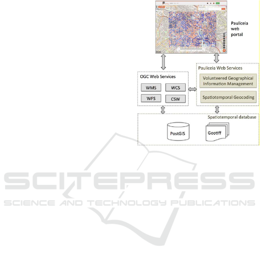
Platform’s architecture is illustrated in Figure 1.
The Platform uses VGI (Volunteered Geographic
Information) protocol and Geocoding web service
which are in line with the demands from the digital
humanities community. VGI can be considered as
crowdsourcing as voluntary citizens can produce and
disseminate geographic information in online sites
that have been made available for this purpose.
Something similar occurs with OpenStreetMap. The
major advantage is that such initiative contributes
Figure 1: Pauliceia 2.0 Platform Architecture. Source:
Ferreira et al., 2018.
towards producing information and with minimal
costs. Naturally, it is important to keep an eye towards
the quality of data. This is achieved by following the
published guidelines to implement strict protocols in
order to standardize the collaborations (Mooney et al.,
2016). VGI consists of tools to create, organize and
disseminate geographic data based on collaboration
from voluntary individuals [Goodchild, 2007] and
[Goodchild & Li, 2012]. VGI types are maps,
images and text. Maps correspond to basic
geometries: points, lines and polygons. The protocols
to guarantee the quality of data input by collaborators
is implemented in the platform.
Georeferencing is related to geographic data
associated with spatial location in terms of latitude
and longitude coordinates [Carter, 1989]. The
features of geographic elements are particular
properties and their spatial relationships with other
elements [Medeiros, 1994]. This is something quite
common nowadays when one needs to locate an
address. One accesses Google Maps not only to
determine the location but also a route to reach that
address. Therefore, Geocoding is nothing more than
converting textual attributes such as addresses (Street
or Avenue and a number) into geographical
coordinates. Determining coordinates from textual
addresses is one of the most important procedures of
Geocoding (Câmara et al., 2005). Similarly, to the
VGI protocol, the platform also provides a tool to
Collaborative Historical Platform for Historians: Extended Functionalities in Pauliceia 2.0
461

measure the precision of the geolocation returned by
using Euclidean distance. Pauliceia provides a
geocoding algorithm able to transform historical
textual addresses into geographical coordinates. The
algorithm operates on spatiotemporal data sets, that
is, spatial entities whose geometries and attributes
vary over time. The challenges of creating an address
geocoding system for historical data are mainly
related to the variation of names, geometries and
numerations of streets and buildings over time. The
geocoding algorithm of this database takes into
account all valid periods associated with spatial
entities.
The top part of the Figure shows the access to the
Platform by means of a browser. The Platform, at the
moment, is hosted at INPE (National Institute for
Space Research). It is open source, online and service
oriented. In the middle part, Figure 1 shows to its left
standard web services specified by OGC (Open
Geospatial Forum). The services to the right are
project specific to support VGI and spatio-temporal
Geocoding (Ferreira et al, 2018).
The objective of this paper is to present the
Platform for Historians that is being developed. It is
collaborative and open source where anyone
interested in history will be able to upload
information along with important files such as audio
or video and even images. After the platform has been
made available for beta tes.ts with the community of
historians, several requests have been made to
implement some improvements. Therefore, these
improvements made for the Platform are also
discussed. A case study is shown of how relevant
such a platform is.
The paper is organized as follows: Section 1.2
presented a brief description of the present status of
the Platform. Section 2 presents similar available
platforms. Section 3 discusses the improvements
made to the Platform while Section 4 shows a case
study and the Conclusions in Section 5.
2 BRIEF REVIEW OF SIMILAR
PLATFORMS
A platform that is very popular is OpenStreetMap
(OSM) and also implements VGI (Volunteered
Geographic Information). Geographical data can be
edited and operated by users based on open content
license. Two applications must be mentioned:
HistOSM (http://histosm.org)) and OpenHistorical
Map (http://www.openhistoricalmap.com). The
former is a web application enabling visualization of
historic objects (monuments, churches, etc.) stored in
the OSM database. The latter uses the OSM
infrastructure to create a detailed historic map of the
world.
Another project, The Atlanta Explorer, is used to
create historical databases and 3D models of Atlantic
City for the period of post Civil War to 1940. There
is a web portal that enables users to explore such
maps. Several topics have been explored to generate
content (Page et al., 2013).
By employing crowdsourcing to create
representations of building footprints was promoted
by The New York Public Library. The footprints refer
to insurance atlases from 1853 to 1930 in New York
City. Machine learning algorithms were trained by
using volunteered information to recognize building
shapes. A consensus polygon algorithm is used to
extract a single polygon to represent each building
(Budig et al, 2016).
Websites for The Digital Harlem
(http://digitalharlem.org) contain legal records,
newspapers, and other material to inform on everyday
life in the Harlem neighborhood of New York City.
The period covered was 1915-1930. People can
search for events and places and have an advantage of
creating interactive web maps.
A project of The British Library employs
crowdsourcing to georeference historical maps and
disseminate them through the web (Southall & Pridal,
2012). An online georeference tool was made
available. It is also possible to overlay historic maps
with the present maps so that one can compare
different periods in time.
The dissolution of religious orders within the
context of urban transformation in Lisbon (19th
century) was developed in the project Lx Conventos
(Gouveia et al, 2015). The system to be developed is
to enable spatial and temporal navigation.
Another project to create roads and streets of
France in the 18th century was developed by (Perret
et al, 2015). Maps were digitized by collaborative
methodology. Another project in France proposes
collaborative geocoding in History. It is open source,
open data and extensible (Cura et al., 2017).
The platform imagineRio (http://hrc.rice.edu/
imagineRio/home) by Rice University is developed to
understand the social and urban evolution of the city
of Rio de Janeiro, Brazil. It is organized under several
perspectives from artists, maps and architectural
plans both in space and time. It is an open access
platform.
Kudaba project (Imhof & Freyberg, 2015) intends
to deliver a collaborative platform as a possible
solution to enhance the Digital Humanities and to
WEBIST 2021 - 17th International Conference on Web Information Systems and Technologies
462
integrate Citizen Science. Like museums, archives
and libraries, citizens can also publish their own
photographic or digital representations of cultural
objects and also share their knowledge and skills for
instance transcribing historical handwritten texts on
this collaborative platform. Kudaba is currently a
privately developed and financed prototype.
Although there is no platform, (Terras, 2016)
presents a survey on the growth of crowdsourcing for
culture and heritage, in particular, within Digital
Humanities. The main point discussed is the
engagement of the public and raises a question on
how technologies can attract a significant number of
people to engage in tasks usually dedicated to the
researchers in the digital humanities field.
The projects described above have many
similarities with Pauliceia 2.0. Most of them also use
crowdsourcing and VGI concepts. The main
difference is the sharing aspect among historians of
the geographical data sets based on their research.
Pauliceia 2.0 platform enables collaborative work for
digital humanities based on free knowledge sharing.
More details of the Platform’s VGI can be seen at
(Ferreira et al., 2018).
3 PLATFORM IMPROVEMENTS
Three new improvements were developed in
Paulicéia: a) data export to GeoJSON format; b)
development of API to include information in
georeferenced points; c) addition of information in
the layer data visualization.
3.1 GeoJSON
Pauliceia exports georeferenced data in shapefile
format. There are fourteen geometric shapes
supported by the shapefile format: point, multipoint,
polyline, etc.
Shapefile format can be viewed and manipulated
in any software that supports the GIS format.
Shapefile cannot store more than one type of
geometry. So, the header of the main contains a flag
to indicate which geographic format it represents.
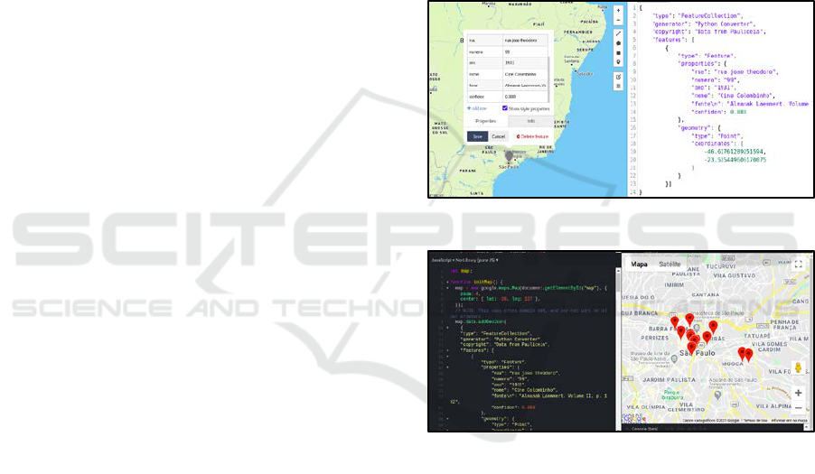
A new feature that was developed in Pauliceia is
the export of data in GeoJSON format. GeoJSON is a
geographic data structure based on JavaScript Object
Notation (JSON). GeoJSON is a format for encoding
a variety of geographic data structures. Geometric
objects with additional properties are Feature objects
(GeoJSON, 2021). Sets of features are contained by
FeatureCollection objects.
GeoJSON supports the following geometry types:
Point, LineString, Polygon, MultiPoint,
MultiLineString, and MultiPolygon. In GeoJSON it
is possible to add tags not defined in the GeoJSON
documentation. They are defined as "Foreign
Members".
The characteristics of the Pauliceia objects are in
the “properties” tag and the others as tags of the same
level. “Sao Paulo downtown movies in 1931” were
exported to GeoJSON format.
The created GeoJSON was imported into the
platform geojson.io. Figure 2 shows the values
contained in the ”properties“ and ”coordinates“ tags.
Figure 3 shows the GeoJSON file imported into the
Google Maps API.
Figure 2: Pauliceia GeoJson in geojson.io. Source: Authors.
Figure 3: Pauliceia GeoJSON in Google Maps API. Source:
Authors.
3.2 API to Include Information to the
Existing Points
One of the Platform demands for the API is to include
information to the already existing points in the
layers. With the inclusion of information in the
Platform, other studies will take place within the
multidisciplinary scope of the Pauliceia 2.0 Project.
This extension may help decision-making processes
with respect to planning urban spaces, based on
historical data of these areas.
This functionality is still under development and
a script with an API must be available very soon to
access the database directly.
Collaborative Historical Platform for Historians: Extended Functionalities in Pauliceia 2.0
463
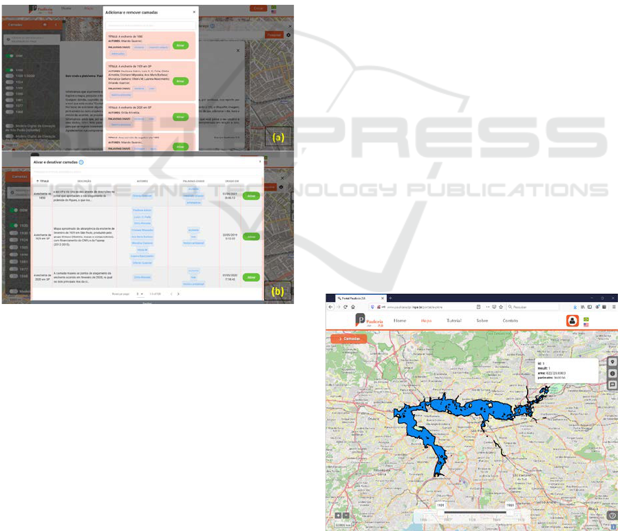
3.3 Query Visualization
Researchers using the Platform requested
improvements of the query of the registered layers
during their activation. The team implemented new
search filters in the query and optimized the layout
of the results. Figure 4 shows (a) the initial query
screen and (b) the optimized version, with more
options.
New information has been added to the Layers
screen: layer description and creation data/time.
The layer title, authors and keywords are in the
previous version of the Pauliceia.
Previously, to enable or disable a layer, the
search was performed only by the layer name. Now
it is possible to search layers by keyword and author.
The layer title can be sorted in ascending or
descending order.
Figure 4: Pauliceia 2.0 interface (a) initial query screen and
(b) improved query screen. Source: Authors.
These new features will help researchers in
enabling and disabling layers.
3.4 Platform Usability
The platform was released in two steps. First, it was
released to those working in the area of History to
provide feedback whether the user interface made
sense. After this first feedback, improvements were
made to make the platform more user-friendly. In its
second release to the general public, more and more
feedback has been returned and the platform is
continuously being improved. Some accesses from
abroad have also been noted. As usual, there is still a
lot to improve and the team is working not only on
the aspects of including more functionalities but
always keeping in mind a proper interface to attract
more users. Plans exist to develop a mobile app and
this depends on funding.
4 CASE STUDY
Currently in the testing phase, the Pauliceia Platform
has been used by researchers for Historical studies
and in courses and workshops at the Federal
University of São Paulo (UNIFESP), at the
University of North Carolina (Winston-Salem) and
at ITA (Instituto Tecnológico de Aeronáutica).
Thus, new demands for improvements showed up.
A case study referring to the layers that portray
floods in the city of São Paulo will be presented in
this section. It is noteworthy that the use of Pauliceia
even goes beyond the initial purpose of the Platform,
allowing the Project Team to glimpse promising
prospects for application.
The Folha de São Paulo newspaper
(https://www1.folha.oul.com.br/cotidiano/2020/02/
sao-paulo-revive-mesmas-enchentes-ha-91-
anos.shtml) used a 1929 map produced by the
Hímaco (History, Maps and Computers) group
website to prepare and publish an article about the
flood that occurred in the city of São Paulo, Brazil
in 2020.
A layer for the 2020 flood was created on the
Platform. The overlapping of the two layers allows
for historical analyses that identify persistent
continuities of the flooded areas in the city, as the
article concludes.
Figure 5: Pauliceia 2.0 interface for layer visualization.
Source: Authors.
WEBIST 2021 - 17th International Conference on Web Information Systems and Technologies
464
4.1 São Paulo 1929 Flood Visualization
The study of the São Paulo 1929 flood was based on
a doctoral thesis at the University of São Paulo in
1984 (SEABRA, 1987). The layer was inserted into
the Platform by Himaco Grupo. Figure 5 shows the
approximate map of the area hit by the February
1929 flood, with São Paulo city as the background
map.
In addition to the map, information about the
study and metadata are inserted into the Platform.
Figure 6 displays the data for this study.
Figure 6: Pauliceia 2.0 interface for viewing layer
information. Source: Authors.
4.2 São Paulo 2020 Flood Visualization
In February 2020, another flood of great proportions
occurred in the city of São Paulo. An article was
published by the Folha de São Paulo newspaper based
on data from the Emergency Management Center -
GCE.
The newspaper obtained the 1929 map from the
Hímaco group website and could visualize the area
affected by the 1929 flood to be compared with the
2020 flood. A new layer was inserted in the Pauliceia
Platform by the Hímaco Group (History, Maps and
Computers) with information of the 2020 flood.
Figure 7 shows the map with the flooded points,
according to information provided by the Emergency
Management Center of the capital (GCE).
The authors emphasize that even outside the
coverage period initially proposed by the Pauliceia
Platform, the new layer contributes to the
understanding of the historicity of the city's current
phenomena, since the Platform allows visualizing the
two floods on the same map, as shown in Figure 8.
Figure 7: Map visualization with the flooding points of the
February 2020 flood in São Paulo, Brazil. Source: Authors.
This approach is capable of enriching the project's
possibilities, expanding its perspectives and
indicating possible new ways of use.
Figure 8: joint view of the 1929 and 2020 floods in the city
of São Paulo, Brazil. Source: Authors.
5 CONCLUSIONS
The Pauliceia 2.0 Platform is an outcome from an
interdisciplinary Project involving historians,
computer scientists and students from both Digital
Humanities and Computer Science. An important
contribution of this work is the collaboration among
Historians to share their research. For this, VGI
protocol and Geocoding Technologies are used. The
Platform is used by Researchers from different
Institutions from different locations. This generates
new demands and allows the necessary adjustments
to the Portal's functionalities.
The Project team is available to share the Platform
with other institutions that want to carry out a similar
project for their cities. In the next stage of the Project,
there will be a collaboration, in a pilot study, with the
PUC Campinas, which will develop the historical
mapping for that city. In addition, there are plans to
include other periods. The period covered by the
Platform is from 1870 to 1940.
Collaborative Historical Platform for Historians: Extended Functionalities in Pauliceia 2.0
465

ACKNOWLEDGEMENTS
Our thanks to FAPESP/FAPESP eScience Program
(Scholarship 2016/04846-0) for funding Phase 1 of
the Pauliceia project and, also for granting
scholarships: #2017/03852-9, #2017/11637-0, #
2017/11625-2 and #2017/11674-3.
REFERENCES
Budig, B., Van Dijk, T.C., Feitsch, F., Artega, M.G. (2016)
Polygon Consensus: Smart Crowdsourcing for
Extracting Building Footprints from Historical Maps.
In 24th ACM SIGSPATIAL Intl Conf on Advances of
GIS. pp. 66
Câmara, et al (2005); Banco de Dados Geográficos.
Publisher Mundogeo.
Carter, J. (1989) Fundamentals of Geographic Information
Systems: A Compendium Chapter on Defining the
Geographic Information Systems. American Society
for Photogrammetry and Remote Sensing. 3-8.
Cura, R., Dumenieu, B., Perret, J., Gribaudi, M. (2017)
Historical Collaborative Geocoding. arXIV Preprint
1703.07138.
Ferreira, K.R., Ferla, L., Queiroz, G.R., Vijaykumar, N.L.,
Noronha, C.A., Mariano, R.M., Taveira, D., Sansigolo,
G., Guarnieri, O., Rogers, T., Lesser, J., Page, M.,
Atique F., Musa, D., Santos, J.Y., Morais, D.S.,
Miyasaka, C.R., Almeida, C.R., Nascimento, L.G.M.,
Diniz, J.A., Santos, M.C. (2018) A Platform for
Collaborative Historical Research based on
Volunteered Geographic Information. Journal of
Information and Data Management. 9(3), pp. 291-304.
GeoJSON Format. Available at: geojson.org. Accessed on:
july, 2021
Gouveia, G., Branco, F., Rodrigues, A., Correia, N. (2015)
Traveling through Space and Time in Lisbon’s
Religious Buildings. Digital Heritage. Vol. 1. pp. 407-
408.
Goodchild, M.F. (2007) Citizens as Sensors: the World of
Volunteered Geography. GeoJournal. 69(4). 211-221.
Goodchiled, M.F.; Li, L. (2012) Assuring the Quality of
Volunteered Geographic Information. Spatial Statistics.
Vol. 1. 110-120.
IBGE. (2011) Tabela 1287-População dos Municípios das
Capitais e Percentual da População dos Municípios das
Capitais em relação aos das Unidades de Federação nos
Censos Demográficos. Disponível em: https://sidra.ib
ge.gov.br/tabela/1287#/n6/3550308/v/591/p/all/l/v,p,t/
resultado. Last accessed on July 22nd 2021.
Imhof, A., Freyberg, L. (2015) Kudaba: A Collaborative
Platform for Digital Humanities and Citizen Science.
Interdisciplinary Conference on Digital Cultural
Heritage-DCH2015. Berlin, Germany
Medeiros, C.B.; Pires, F. (1994) Databases for GIS. ACM.
New York.
Mooney, P.; Minghini, M.; Laakso, M.; Antoniou, V.;
Olteanu-Raimond, A-M.; Skopeliti, A. (2016) Towards
a Protocol for the Collection of VGI Vector Data.
ISPRS International Journal of Geo-Information. 5(11).
Page, M.C., Durante, K., Gue, R (2013) Modeling the
history of the city. Journal of Map & Geography
Libraries. 9(1-2). pp. 128-139.
Perret, J., Gribaudi, M., Barthelemy, M. (2015) Roads and
Cities of 18th Century France. Scientific Data 2
(150048). pp. 1-13.
Seabra, O. C. L. (1987) Os meandros dos rios nos meandros
do poder: O processo de valorização dos rios e das
várzeas do Tietê e do Pinheiros na cidade de São Paulo.
São Paulo: Tese de Doutoramento FFLCH, USP.
Southall, H. & Pridal, P. (2012) Old Maps Online: Enabling
Global Access to Historical Mapping. e-Perimetron.
7(2). pp. 73-81.
Spiro, L. (2012) This is why we fight: Defining the values
of the Digital Humanities. Debates in Digital
Humanities. Eds. Terra, M. Quantifying Digital
Humanities.
Terras, M. (2016) Crowdsourcing in the Digital
Humanities. In: A New Companion to Digital
Humanities. Schriebman et al., (Eds). pp. 420-439.
WEBIST 2021 - 17th International Conference on Web Information Systems and Technologies
466
