
Increasing Business Opportunities for Drone Services
S. Brezani
1
, R. Hrasko
1
, D. Vanco
1
and P. Vojtas
1,2 a
1
Globesy ltd., Framborska 58, Zilina, Slovak Republic
2
Dpt. Software Engineering, Charles University, Malostranke nam. 25, Prague, Czech Republic
Keywords: UAV Imaging in Business Processes, B2C/B2B Considerations, Drone Services, Machine Learning.
Abstract: We describe our UAV imaging research and development from a business perspective. Our main goal is to
increase business opportunities for our drone services. We build on experiences from an already deployed
drone service provided by our IT company. The application is using a commercial tool for processing
photogrammetry. Its advantage is accuracy, but the main disadvantage is the time needed for annotation by a
trained human operator. Our methodology is based on user studies and knowledge gained in communicating
with potential customers at IT trade fairs and exhibitions. We analyse the duration and automation of the
service as key factors. We consider two types of higher automation of the solution. First is the automation of
annotation - less accurate, without human intervention. The second is automation in flight planning and
implementation. The use of other drone peripherals or hybrid drones can also create new types of services. In
particular, there is a demand for immediate execution of on-site flight imaging without any pre-calibration.
Our considerations, expanding our services, also include various inspections or direct involvement in
industrial processes. Some improvements were tested on an experimental prototype. The results indicate
improvement making services cheaper and faster.
1 INTRODUCTION
We describe our UAV imaging research and
development from a business perspective. Our main
goal and objectives are related to increasing business
opportunities for our drone services.
The author's team consists of the academia and
R&D department of an IT company.
In the beginning, the company has been trying to
gain a new perspective of using drones in commercial
tasks and founded a flight service department.
We quickly realised that we could use drones in
various cases where humans have limited access or
the standard approach takes very long. Following this,
we acquired the conviction that by using the
equipment drones can carry, we can collect a wide
variety of data in an immense amount.
After deciding to follow these ideas, we were able
to finish and market our first service deployment. To
address the further expansion on the market, we are
looking for new opportunities for our services. Our
ambition is to make them cheaper and faster for
greater competitiveness. The use of other drone
a
https://orcid.org/0000-0002-3526-8475
peripherals can create new types of services as well.
Our considerations, expanding our services, also
include various inspection types or direct
involvement in industrial processes.
The main contributions of our paper are
following:
• experiences learned from our first deployed
service point to critical factor of service duration
• experiments with our experimental tool from the
point of view of time complexity
• further directions of development with different
level of construction and evaluation, namely
− proof of concept of flight planning
automation
− further considerations of extensions based
on experiences
o LIDAR in unknown uncalibrated areas
o drones extended by peripheral devices
o image recognition inspection
The paper is organised as follows: Chapter 2
describes our starting point with a deployed tool,
lessons learned from customers, and the first
technical attempt to improve it. Chapter 3 describes
Brezani, S., Hrasko, R., Vanco, D. and Vojtas, P.
Increasing Business Opportunities for Drone Services.
DOI: 10.5220/0010566900930100
In Proceedings of the 18th International Conference on e-Business (ICE-B 2021), pages 93-100
ISBN: 978-989-758-527-2
Copyright
c
2021 by SCITEPRESS – Science and Technology Publications, Lda. All rights reserved
93

ongoing work, partly, not yet fully validated in
different directions regarding further development
and some speculative ideas. Chapter 4 is related
work. We conclude with achieved results so far, the
future work is devoted to general B2B considerations
about our products' future, especially in the
automotive industry.
2 DEPLOYED UAV SERVICE
We build on experiences our already deployed drone
service developed in our IT company. The customer
requires computing volumes of wood in stock. The
application is using a commercial tool for processing
photogrammetry. The advantage is accuracy, but the
main disadvantage is the need for a trained human
intervention.
Technical description of this solution was
described in (Brezani, 2021). In the following, we
explain how we proceeded, especially in business
considerations.
The product itself is already on the market. It is a
service using a commercial photogrammetry
processing tool for precise measurement and
evaluation. The whole process begins by setting
calibration points, placing them manually, and
marking a known length on-site. Our staff workers
personally create calibration points on the ground
close to the measured area. It makes a base for precise
calibration in the orthophoto map processing method,
which comes later in the procedure.
The next step is to prepare the drone flight data
manually to capture the entire area, focusing on the
material supplies' location. Subsequently, the drone is
ready to fly to take appropriate area pictures. The
flying route is designed depending on the shape of the
object being scanned itself.
Afterwards, photos are taken and collected to fit
automatic processing by a commercial tool, which
creates an orthophoto map. A trained user manually
annotates the areas of interest (wood stock, the
volume should be calculated). It takes a trained user
at least half an hour, depending on the ground area
and object's shape. The procedure ends by
calculating the required material stockpile volume.
The first mission was to estimate the volume of
current material stocks and their changes over time in
the customer warehouse. It took several months for
enough measurements to be made to evaluate the
movement of material in the warehouse.
We focused on several factors that must be
considered separately for specific flight conditions in
different weather conditions when performing
measurements. Each scan and measurement brought
various issues. Meteorological conditions influence
flights to a large extent. It is necessary to modify
predefined plans for flight safety assurance and to
create an optimal setting of the measurement mission
in various conditions.
The main challenge was to reduce the time needed
for the whole procedure and eliminate the manual
interventions and expert labour needed in processing.
The higher requirements on precision require more
processing time in the range of hours to days.
Likewise, manual interventions and professional
work were an obstacle to a significant reduction in
time and full automation of the process. Intelligent
automation was necessary to address processing time.
3 EXPERIMENTAL TOOL
Technological description of our experimental tool is
reported in (Brezani, 2021). The main idea was the
ability to extract information for the customer's
information system. Here we only briefly summarise
the part replacing manual annotation, which is
important for our business considerations. We
decided to use the neural network method of
automated annotation of areas of interest to address
the problem. We used open-source software to create
an orthophoto area map. The orthophoto area map is
then automatically annotated by a neural network
semantically segmenting each pixel of the input
image to see if it belongs to the monitored object. The
before-mentioned network is trained on manually
annotating the initial machine learning examples. It is
important to notice that this annotation is done only
once for the domain). The type of monitoring object
is decided in advance in order to prepare and train a
machine learning model for this task concerning
customer needs. It is time-consuming, but it is a one-
time job, the result of which can be used repeatedly
in services of the same type.
We are using an open-source data labelling,
annotation, and exploration tool to annotate the
images. The goal is to mark the woodpiles (as a pilot
task) on a sample of pictures. Subsequently, we split
the data images into a training dataset, a validation
dataset, and a test dataset. To enlarge the size and
diversity of annotated data, we pick augmentation
within the training cycle to prevent overfitting in
neural networks (Ronneberger, 2015). We were
trying a wide range of transformations to convert both
image and segmentation data. In our case, we are
using affine transformations (rotation, shift, zoom),
contrast adjustment, noise generation, etc.
ICE-B 2021 - 18th International Conference on e-Business
94

To replace human annotation of the area of
interest, we apply the segmentation models library as
a ground for our work. The library implements four
model architectures for binary and multi-class
classification. It uses the transfer learning method and
allows using one of the pre-trained networks as a
backbone for the semantic segmentation architecture.
The technique makes it possible to use a trained
neural network, or part of it, for related categories of
tasks. For more details, see (Brezani, 2021).
3.1 B2B Considerations
In this chapter, we show the results of our
methodology. Our methodology is based on user
studies and knowledge gained in communicating with
potential customers at IT trade fairs and exhibitions.
Based on this, we analyse the duration and automation
of the service as key factors. We consider two types of
higher automation of the solution. First is the
automation of annotation - less accurate, without
human intervention, and hence faster. The second type
of automation will be treated in the next chapter.
In the previous chapter, we have described the
construction of our experimental tool based on deep
neural network annotation. Here we report on
measuring improvements that were tested on an
experimental prototype. The results indicate
improvement making services cheaper and faster.
Hence this is an indication that we can expect
improvements in goals and objectives.
Nowadays, our ambitions aim to automatically
collect outdoor visual data using pre-programmed
UAVs and automatically process and transform them
into knowledge using advanced computational tools
such as machine learning based on deep neural
networks. Deploying this solution to a real production
facility will bring the capability of automatic data
collection from different devices and their processing
regularly, with possible direct integration to core
information systems in the form of direct data
transfers or, for example, gained knowledge in the
form of alerts. This way, the outdoor reality could be
manageable almost in real-time.
Let's imagine a system that can proceed
automatically without intervention. In that case, we
could streamline the entire process of regular daily
inventory measurements and at the same time
effectively evaluate and monitor the movements and
volume changes of material in the warehouse. We
could potentially get an overview of materials'
movement over large areas of one or more
warehouses of different customers. It would find
justification in many industries by extending today's
limited capabilities to almost unlimited use with
automated drones for regular inventories. Of course,
this is the hope our experimental tool is bearing. It
needs much more work to ascertain and evaluate this
in practical deployment.
Many machine learning tools are distributed as
open-source and are suitable for commercial use.
However, the use of these tools is not trivial and
requires considerable know-how and data. Therefore,
we must include this in the market price of the
instrument. Using open software for machine learning
and processing UAV data, we save on a professional
license for photogrammetry and at the expense of a
trained user. The time saved in terms of speeding up
the procedure will improve our position in the
competition.
In the following section, we describe the effect of
the measured area and the time required to perform
the whole procedure. We also provide further details
here regarding the individual terminations that take
place in the service. These data come from
measurements already performed.
The measurement parameter ranged between 18-
30ha(hectare) for double grid mapping range and
resolution level up to 2 cm/pix. Increasing the
measurement area is directly proportional to the
extension of data processing time.
The diagram in Figure 1 analyses the difference in
the service duration in areas of 100 ha and 30 ha. It
also shows the expected time savings by introducing
automatic and autonomous parts of processes in
several phases. The procedure can be accelerated by
automating manual processes, to which we would be
able to provide results periodically, e.g., every hour.
Thus, it would be possible to continuously control the
increase or decrease of the amount of material.
Customers thus receive a continuous overview of
stockpiles (in the domain of our first deployment)
inventory of materials every hour, every day, month,
and year.
The preparation phase usually lasts 2-4 hours,
depending on the measurement's conditions and nature.
The flight usually takes 40-70 minutes.
The computation phase usually takes 3-10 hours
for maximum quality. The fastest result is within 60
minutes, with an accuracy of around 70%. More
accuracy needs more processing time. The resulting
accuracy can increase to 91-97% over time, but it is
time-consuming. The standard accuracy is around
80%. The required time for the entire procedure with
80% accuracy is, on average, from 5 to 22 hours
together. The following diagram compares each
phase's average duration.
Increasing Business Opportunities for Drone Services
95
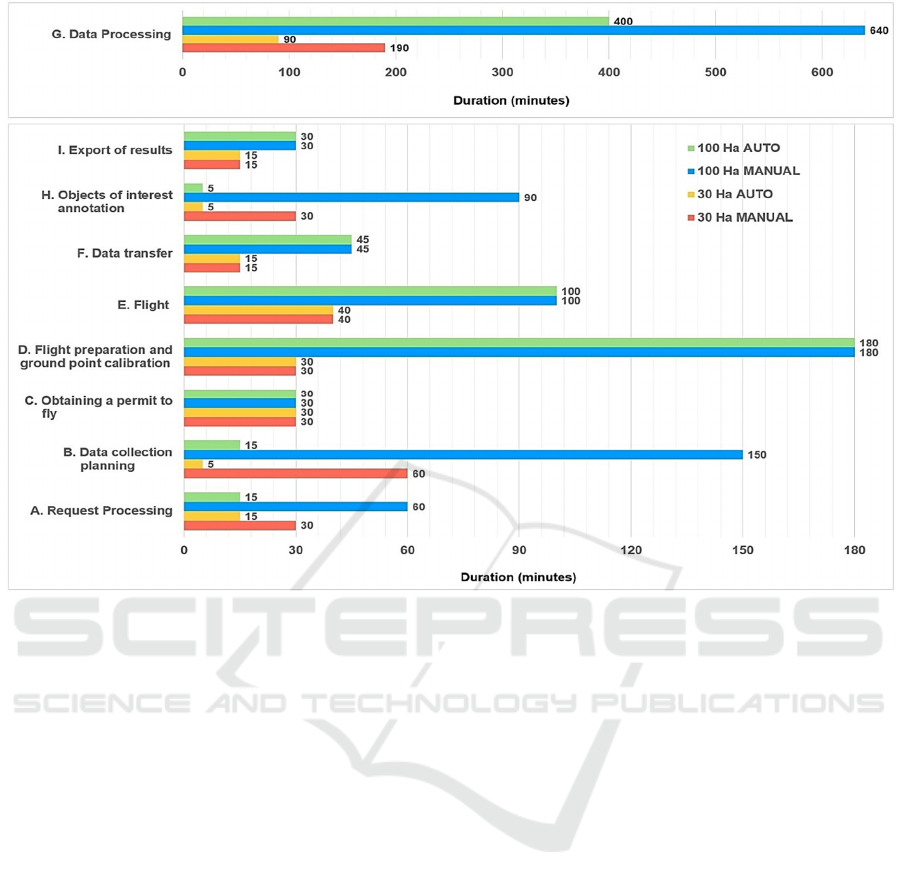
Figure 1: Dependency of processing time, the area, and auto or manual processing shows some huge discrepancies in G. Data
Processing activity which depends on server power. But our focus is mainly on processing steps, which shows the best
improvement by introducing smart technologies, which is apparent in activities B. Data collection planning and H. Objects
of interest annotation. The diagram shows that automatic annotation is one of the key factors to save time and resources.
3.2 Market Situation
Here we summarise the outcomes of our informal
market study. We do not discuss the formal metric
evaluation. On the other hand, this is a continuous
process and depends on the increase of our
experiences.
Several aviation companies are operating in the
market for air inspection services, collecting and
processing aviation data. In our survey, we focused
on providing the maximum added value. Our output
against the competition differs in terms of data
collection to processing and clear presentation of
results. The data collection method's contribution is
more precise thanks to the methodological procedures
and tools used in the solution. Data collection results
are processed by sorting and simple editing of photo
data and then imported into a smart user-friendly
application. The application is available on smart
devices such as mobile phones or tablets. The outputs
are more exact and linked to the location, so the
customer gets accurate data based on which he can
evaluate the current state from a distance. Regular
data import from individual measurements gives
another added value, namely the development of
parameters in time.
The application also contains several tools, thanks
to which it is possible to store status assessment notes
in the photo data. In this way, it is possible to mark
abnormal sites suitable for preventive monitoring.
Regular monitoring helps eliminate power outages by
early detection of the problems in the initial stages.
Finally, our product's descriptive advantages are
access to the databases of individual objects for
assessment. The application is available for Android
and iOS devices, as well as for Windows. In
conclusion of our internal study, the competition does
not provide such benefits in such a form.
4 FURTHER DIRECTIONS
In this chapter, we describe several further directions
of development with different levels of construction.
Some are in the form of proof of concept, and some
ICE-B 2021 - 18th International Conference on e-Business
96

are speculations (as encouraged by organisers of call
for position papers).
As mentioned in the previous chapter, there is a
second type of increased automation in flight
planning and implementation. Proof of concept gives
us hope that this can contribute to goals and
objectives.
Further, we mention that using other drone
peripherals or hybrid drones can also create new types
of services. In particular, there is a demand for
immediate execution of on-site flight imaging
without any pre-calibration.
Our considerations, expanding our services, also
include various inspections or direct involvement in
industrial processes.
4.1 Flight Planning Automation
In order to shorten the overall duration of the services
and obtain regular and up-to-date data, we proposed
simplifying respective processes so that, as a result,
we can provide repeating services for the recurring
daily needs of the customer. It was necessary to
increase the automation of processes that today take
several to tens of hours and shorten them to minutes.
The process of realising the request for specific data
from the field begins with defining the exact
requirements of the customer. The following is
validated as proof of concept. For this purpose, we
have created a smart application on the web interface
into which the customer directly enters his request,
defines, e.g., the type of data he is interested in, e.g.,
measurement of quantities, map creation,
measurement of warehouses, etc., then enters the
request for the location and the time of execution. It
saves a lot of time in the consultation as the client's
requirements are clearly defined. Of course, it
remains to test the intuitiveness and self-
explainability of our interface.
Based on the request, we are ready to schedule the
autonomous flight so that during it, the drone
performs the necessary data collection. We plan the
flight mission so that the data collection is carried out
safely and so that the necessary data is collected in the
highest possible quality during the mission.
According to several criteria, dependent on the shape
or type of data needed, we set the plan in the flight
planner and adjust the operation of the individual
peripherals. So far, when the flight plan is ready, the
pilot/copilot flight unit drives to the place of activity,
sometimes 100s of km away from the place of the lab.
For this reason, we have designed an automatic
drone box to be placed in an industrial area, from
which the drone is ready to take off and execute the
planned flight within a few minutes. With this
process, we can save a lot of time which can be used
for the implementation of the customer's requirement.
The implementation and data collection will take
place autonomously and under the same conditions
repeatedly. There is no need to plan the flight for each
request. Thus, after the data collection process, we
can import the raw data directly to our remote
processing PC after successful landing by the ground
box. After receiving the data, the metadata check and
verification of correct execution follow. If everything
went well, then the raw data processing into usable
data for the customer as defined in our application
interface follows.
Data processing is a process that takes several
hours in common practice today, depending on the
application. Still, our contribution in the field of
automation and machine learning has pushed the
boundaries and thus shortened this process to the
level of minutes. This is due to the fact that there is
not so much manual work of a trained worker in the
field of post-processing. The software can
automatically recognise and automatically annotate
the object in the scope of interest (as described in the
experimental tool). This way, we can streamline the
processing time by only working with the relevant
data and not processing the rest.
Automating data processing is a key element for
reducing process time and making services cheaper
because it requires minimum manual work.
4.2 Further Extensions
Previous research was evaluated by deployment,
experiments, and proof of concept. In the following
chapter, we describe our further considerations.
4.2.1 LIDAR in Unvisited Uncalibrated
Areas
In the meantime, we have improved our UAVs by
extending our equipment. Our main idea when using
LIDAR is that it will be possible to calibrate the map
without the need for expert intervention.
LIDAR can be an exciting source of data for
automated processing with machine learning. Such as
in self-driving cars - (Sometimes, artificial
intelligence can make better predictions than a human
could because it can access different data, such as
feeds from cameras, RADAR, and LIDAR around a
car (Agrawal, 2019)
LIDAR is a 40 times heavier device than a regular
camera. It is used only in the case of measurements at
the level of cm, where it is necessary to shift
Increasing Business Opportunities for Drone Services
97

photogrammetry accuracy to a limit of less than 5%.
The LIDAR deviation level is 1-2%, and mapping a
large area is several times faster. Data processing
requirements increase by 20-30 times. The use of
LIDAR is intricate and reduces the drone's flight time,
which increases the cost. It is always necessary to
consider its benefits from shooting with a full-frame
camera.
Besides, this could open up the possibility of
using UAVs in new, unknown areas. We hope this
can attract some customers to use our on-call services,
so we increase our operability. We keep in mind
mountain rescue operations, which cause many
fatalities in our country each year.
To increase the overall efficiency of air services,
we have proposed a procedure for accelerating data
collection through flight automation. In the next step,
it is necessary to adapt the sensors. We know from
practice that it is necessary to obtain a lot of accurate
data for customers. The solution is to use a LIDAR
sensor for mapping large areas over 100ha. Mapping
large areas have great potential for customers, e.g.,
from forestry, agriculture, and automotive.
4.2.2 Inspections by Drones
In other areas of our research and development, we
are working on image recognition. Using this
knowledge can help us use drones in inspection tasks.
So we think of classic inspection tasks, such as power
lines, bridges, etc., see, e.g. (Fowler, K. R. and Dyer,
S. A., 2020). Surprisingly, we do not have much
competition in this area in our country.
Inspections using UAVs are based on detailed
optical data collected from a safe distance using a
20 to 30 fold approximation to specifically defined
locations on the object. During the mast's inspections,
we focus on the insulators' damage, the temperature
of the source adapters and antennas, and the condition
of the construction of the handles with the search for
corrosive joints or screws. Camera correction is
necessary, and the manual flight method is time-
consuming.
The inspection procedure depends on the type of
object. The whole inspection must be pre-planned and
programmed using flight simulation and simulation
of the object's camera views. This way, the entire
infrastructure inspections can be planed. Recognising
and distinguishing objects in the current camera view
is a necessary part of the data collection process.
1
https://www.techbriefs.com/component/content/article/tb/
pub/features/articles/23938?start=2
4.2.3 Drone Peripheral Extensions
Peripherals are an integral part of drone equipment.
They are selected based on dimensional limits and
parameters that lead to the efficient management of
drone energy. Preferred tools are elementary sensors
and multiple camera types that can capture a wide
range of map layers from a given area, for example,
IR, NIR, RGB, or others.
By combining several data and linking the
measurements of several types of data to a specific
location, we can provide the basis for a detailed, in-
depth analysis of the object, which is fundamental to
the customer's analytical decision-making and
predictive action.
5 RELATED WORK
Market analysts agree that commercial drones are
revolutionising business operations. For example, our
first deployment changed the inventory processes in
the case of our customer. Further summarisation
reads as follows: Drone industry revenue in the
commercial sector is forecast to grow worldwide by a
compound annual growth rate of 13.8 % from 2020 to
2025, reaching a value of 43 billion U.S. dollars,
according to DRONEII. The biggest drone markets
today are in China and Japan. These are not a result
of research papers. These are global market
observations. In this related work, we sometimes give
voice also to subjective opinions of important market
players.
By reading Tech Briefs magazine, it became
evident that UAVs have become an integral part of
the research that uncovers and makes available their
use in various fields. Detection of dangerous
circumstances, such as gas leakage, mapping of
changes in the form and size of glaciers, monitoring
forest stands with early fire detection, rescue
missions, and industrial processes optimisation are
just some of the magazine's reports. An interesting
fact is that UAVs' use is clearly shifting from
manually operated aircraft to autonomous systems
controlled by computer systems involving artificial
intelligence. E.g. (TechBriefs, 2016)
1
recognised the
need to safely manage UAVs flying at low altitudes
in airspace not currently addressed by authorities.
The American Meteorological Society states in its
research that UAV technology and systems can be
considered a missing piece of the puzzle between
ICE-B 2021 - 18th International Conference on e-Business
98

satellite observations and observations from the Earth's
surface. AMS states that UAV systems' deployment
will increase the accuracy and timeliness of
meteorological parameters measurements, which will
result in better prediction of weather developments and
abnormalities (see, e.g. (AMS, 2013)
2
).
P. Murphy, in his book (Murphy, 2017), ranked
drones and the UAV system among the leading
technologies to move the company to the stage of an
automated company. Interestingly, he identified
transport and means of transport as one of the main
areas for drones (see our future work).
A similar conclusion reached Automotive
Logistics magazine's research, which identified
considerable scope for UAV systems' involvement in
B2B, B2C logistics, and logistics within production
plants and integrated supply chains (see, e.g.
(Williams, 2017)
3
).
Nowadays, global trends concern UAV services.
The next part of related work considers cloud and
SaaS, which is not part of our research but the next
step for our customers. So far, the deployed solution
is running on our servers. Nevertheless, in the future,
we have to consider also this option when the
customer decides.
Cloud-based solutions have significantly
increased the availability of sophisticated and
powerful software solutions for research and
economic entities of all sizes. Chue Hong et al., in
their work (Chue Hong, 2018)
4
, offer a guide for
decision using cloud computing in research. They
warn before too great optimism. One has to check
several questions and dangerous scenarios before
such a decision. Of course, there are also some
benefits possible. (Lakshmi Devasena, 2014) is an
empirical impact study that emphasises the
consequences of adopting Cloud Technology in
business organisations (micro, Small Medium
Businesses (SMBs), and Small Medium Enterprises
(SMEs)) and how it affects business development.
Finally, (Konersmann, 2020)
5
recognise immense
possibilities cloud computing can offer R&D in Life
sciences and health care organisations in the global
pandemic crisis.
We are at a stage where industrial production is
beginning to open up to the use of SaaS-based
software solutions. After the SaaS model's initial
2
https://www.ametsoc.org/index.cfm/cwwce/boards/board
-on-enterprise-strategic-topics/offshore-wind-energy-
annual-partnership-topic-committee/apt-final-report/
3
https://www.automotivelogistics.media/ups-tests-residen
tial-drone-delivery/17665.article
4
https://www.software.ac.uk/best-practice-using-cloud-
research
change, in which industrial institutions moved
administrative and support information systems to the
cloud, the phase of transition to the SaaS model of
critical production systems begins. Based on research
by Statista, the use of SaaS software in production is
expected to increase by almost 100% by 2020 see
(Statista, 2020)
6
for 2008 to 2020 data.
There is a more similar material, but we do not
consider it to be mentioned here given the scope. Now
we mention two research papers relevant to our doing.
In the paper (Fotouhi, 2019), the authors study the
rapid growth of consumer unmanned aerial vehicles
(UAVs), creating promising new business
opportunities for cellular operators. UAVs can be
connected to cellular networks as new types of user
equipment, therefore generating significant revenues
for the operators that can guarantee their stringent
service requirements. We are also motivated by this,
as 5G gives enough throughput and makes AI
computations possible on ground computers.
A substantial part of our development is to create
autonomous flying services. In the paper (Jahan,
2019), they consider autonomous systems integrated
into our lives as home assistants, delivery drones, and
driverless cars. The implementation of the level of
automation in these systems from being manually
controlled to fully autonomous would depend upon
the autonomy approach chosen to design these
systems. This is exactly our position. Motivated by
the author's review of the historical evolution of
autonomy, its approaches, and the current trends in
related fields, we incorporate these ideas in our work.
Another option we have to consider for our goals
and objectives is the decision between build and buy.
(Fowler and Dyer, 2020) propose a model for
recommending build-versus-buy decisions when
developing embedded systems. They compare
designing a custom unit with integrating a
commercial unit into the final product (exactly as we
did on our first deployment with commercial
photogrammetry). It accounts for the expertise of the
development team, tool resources available to the
team, partitioning of the tasks, and quality of
commercial units, vendor support, premiums, and
product life cycles. This is now a challenge for our
R&D department. Especially interesting for our flight
department is the paper (Martin, 2018)
7
mentioning a
5
https://www2.deloitte.com/us/en/insights/topics/digital-
transformation/cloud-enabled-research-and-
development-innovation.html
6
https://www.statista.com/statistics/510333/worldwide-
public-cloud-software-as-a-service
7
https://search.informit.org/doi/10.3316/informit.5911237
71201857
Increasing Business Opportunities for Drone Services
99

global trend of Asia-Pacific nations making strides
towards supplementing foreign helicopter
acquisitions with domestically built projects. Nations
like South Korea, China, Japan, and India are leading
the way with a number of increasingly sophisticated
transport and utility helicopter designs.
6 CONCLUSIONS
This position paper's main topic is studying the
impact of drones in industrial business and B2B
considerations of its comprehensive application. We
describe ongoing work on further development and
ideas from a business perspective. Our foundation is
in already developed and deployed service using
UAV imaging. We dealt with a further extension of
our service's competitiveness by making it cheaper
and faster and extending services to other domains
like inspections and direct industrial processes
involvement. Some of them are in the phase of
evaluated experiments, some are ascertained as proof
of concept, and some are further considerations based
on our previous experiences.
B2B considerations on the impact of the deployed
tool on the market are well advanced. Drones
extended with LIDAR equipment for unknown
uncalibrated areas offer new market opportunities.
Other ideas discussed and reworked relate to drones
with peripheral enhancements and their use for image
recognition-based control. We evaluate our market
positions and competition. Future ideas include
testing applications to support industrial processes in
polytechnic vocational schools to gain experience in
an environment as close as possible to the real
industrial one. We believe that this will bring us
closer to the significant extensions for drone-based
services. We hope this will help us with our future
research topic for drone-based services in the
automotive industry.
We are trying to create synergy between UAV use
to collect and extract knowledge with immediate
feedback to control and manufacturing processes.
ACKNOWLEDGEMENTS
This publication was realised with the support of the
Slovak Operational Programme Integrated
Infrastructure in the frame of the project: Intelligent
systems for UAV real-time operation and data
processing, code ITMS2014+: 313011V422 and
co-financed by the European Regional Development
Fund.
REFERENCES
Agrawal, A. et al. (2019). Artificial Intelligence: The
Ambiguous Labor Market Impact of Automating
Prediction, J. Economic Perspectives 33,2, pp. 31–50
AMS (2013). American Meteorological Society Offshore
Wind Energy Committee Report
Brezani, S. et al. (2021). Deep Learning for Knowledge
Extraction from UAV Images. Submitted to EJC'21
Chue Hong, N., etal. (2018). Best practice for using cloud
in research, Software Sustainability Institute
Fotouhi, A. et al. (2019). Survey on UAV Cellular
Communications: Practical Aspects, Standardisation
Advancements, Regulation, and Security Challenges.
IEEE Comm. Surveys & Tutorials 21,4, pp. 3417-3442
Fowler, K. R. and Dyer, S. A. (2020). A Model for the
Build-Versus-Buy Decision in Developing Embedded
Systems. IEEE Systems Journal, 14,1, pp. 1317-1324
Jahan, F. et al. (2019). Security Modeling of Autonomous
Systems: A Survey. ACM Comp. Surv. 52,5, Article 91
Konersmann, T., etal. (2020). Innovating R&D with the
cloud Business transformation could require cloud-
enabled data, ecosystems, and services, Deloite insights
Lakshmi Devasena, C. (2014). Impact study of cloud
computing on business development, J. Operations
Research and Applications (ORAJ), 1, 01-07
Martin, G. (2018, March). Build or buy: Imported vs
indigenous transport and utility helicopters. Defence
Review Asia. Asian Press Group.
Murphy, P. (2017). Auto-Industrialism: DIY Capitalism
and the Rise of the Auto-Industrial Society, SAGE
Publications Ltd; 1
st
edition
Ronneberger, O., et al. (2015). U-Net: Convolutional
Networks for Biomedical Image Segmentation,
https://arxiv.org/abs/1505.04597
Statista, (2020). Total size of the public cloud software as a
service (SaaS) market from 2008 to 2020
TechBriefs, (February 1, 2016). Aerospace Drone Control:
Flying the Crowded Skies,
Williams, M. (2017). UPS tests residential drone delivery,
Automotive Logistics, digital edition
ICE-B 2021 - 18th International Conference on e-Business
100
