
Derivation of Wildfire Ignition Index using GIS-MCDA from
High-Resolution UAV Imagery Data and Perception Analysis in
Settlement Sali, Dugi Otok Island (Croatia)
Ivan Marić
a
, Ante Šiljeg
b
and Fran Domazetović
c
University of Zadar, Department of Geography, Trg kneza Višeslava 9, 23 000 Zadar, Croatia
Keywords: Wildfire Risk Ignition Index, GIS-MCDA, High-Resolution UAV Imagery, Perception.
Abstract: In recent years, wildfires have become one of the most hazardous natural disasters because of their overall
impact on the natural and urban environment. In this paper, we have generated a wildfire risk ignition index
for the Sali settlement (Dugi Otok, Croatia). This model was generated within the INTERREG PEPSEA
(Protecting the Enclosed Parts of the Sea in Adriatic from pollution) project. Wildfire ignition index is based
on the GIS-MCDA (Multi-Criteria Decision Analysis). The process was performed using 13 criteria grouped
in five clusters. Criteria were derived from high-resolution multispectral (5 bands) orthomosaic and digital
terrain model (DTM) produced from imagery acquired with Matrice 600 Pro and Matrice 210 RTK V2 UAV.
The criteria weights were determined using the AHP (Analytic Hierarchy Process). The model of wildfire
ignition risk was classified into five classes, from very low (1) to very high (5). The model indicates that
14.14 % of the study area falls in a very high (5) ignition risk zone. The fire-risk perception was analyzed and
the wildfire ignition model was evaluated using a questionnaire. The results indicate that all recent wildfire
ignition locations occurred in high (4) and very high (5) risk class. Furthermore, the population recognized
wildfires as a moderate threat to the ecosystem of the wider Sali area. A set of specific management measures
has been proposed to prevent wildfire ignition. This proposed methodological framework and results can
provide valuable information and specific management tools to local government.
1 INTRODUCTION
Wildfire (Pavlek et al., 2017) or wildland fire
(Eskandari, 2017) burns uncontrollably in a natural
environment in which the primary fuel is vegetation.
Wildfire is the one of most hazardous natural
disasters (Bonazountas et al., 2005) and important
cause of land degradation which lead to
desertification, deforestation (Eskandari, 2017), and
destabilization of soil-water conservation (Sharma,
2012). They can have profound effects on global gas
emissions, biodiversity, land cover change, health,
and local economies (Sebastián-López et al., 2008,
Somashekar et al., 2009, Thompson and Calkin,
2011, Ajin et al., 2016). One of the most important
phases in wildfire management are prevention
(Vasilakos et al., 2007, Sebastián-López et al., 2008)
a
https://orcid.org/0000-0002-9723-6778
b
https://orcid.org/0000-0001-6332-174X
c
https://orcid.org/0000-0003-3920-6703
and early detection (Doolin and Sitar, 2005, Hefeeda
and Bagheri, 2007, Vescoukis et al., 2012). Namely,
risk management begins with an assessment of the
areas with the highest possibility of fire ignition
(Gigović et al., 2018). An important measure in fire
prevention is a derivation of the fire ignition risk
(Roland et al., 2015) which can indicate the
vulnerable areas and can provide specific
management tools to authorities (Bonazountas et al.,
2005). Fire ignition risk refers to the chance of a fire
starting as determined by the presence and activity of
any causative agent. It is regarded as an essential
element in analyzing and assessing fire danger
(Vasilakos et al., 2007, Catry et al., 2010).
Identification of factors affecting the ignition of forest
fire is one of the basic tools for forest fire control and
fighting actions. Zonation of fire risk ignition is one
90
Mari
´
c, I., Šiljeg, A. and Domazetovi
´
c, F.
Derivation of Wildfire Ignition Index using GIS-MCDA from High-Resolution UAV Imagery Data and Perception Analysis in Settlement Sali, Dugi Otok Island (Croatia).
DOI: 10.5220/0010465000900097
In Proceedings of the 7th International Conference on Geographical Information Systems Theory, Applications and Management (GISTAM 2021), pages 90-97
ISBN: 978-989-758-503-6
Copyright
c
2021 by SCITEPRESS – Science and Technology Publications, Lda. All rights reserved
of the basic tools for forest fire control and action
measures (Mohammadi et al., 2010).
The Mediterranean, one of the most flammable
ecosystems in the world (Pausas et al., 2016), is one
of the most endangered areas considering the wildfire
(Catry et al., 2010, Pavlek et al., 2017). As a
Mediterranean country, the Republic of Croatia (HR)
(Fig. 1A-B) has a constant increase in the danger of
wildfires, averaging over 1000 registered wildfires
annually (Pavlek et al., 2017) and it is recognized as
a country with high forest fire risk (Stipaničev et al.,
2007). The HR especially has a pronounced risk of
fire ignition in the coastal zone and on the islands
(Pavlek et al., 2017).
This article presents a wildfire risk ignition result
performed within the INTERREG Italy-Croatia
PEPSEA (Protecting the Enclosed Parts of the Sea in
Adriatic from pollution) project. The wildfire risk
ignition index was derived using GIS-MCDA and
acquired high-resolution (GSD<5 cm) UAV imagery
data (RGB and multispectral). Furthermore, the risk
perception about the dangers of wildfires was
examined by a questionnaire. The main goal of the
research was: (a) generate wildfire risk ignition index,
as a part of a quantitative rating system, using the
quickly definable parameters and GIS-MCDA; (b)
propose fire prevention measures based on available
resources of the study area with a basic aim of
reduction of fire ignitions; (c) examine residents'
awareness of a wildfire hazard. The research was
carried out within the drainage basin of the Sali
located on the island of Dugi Otok in HR.
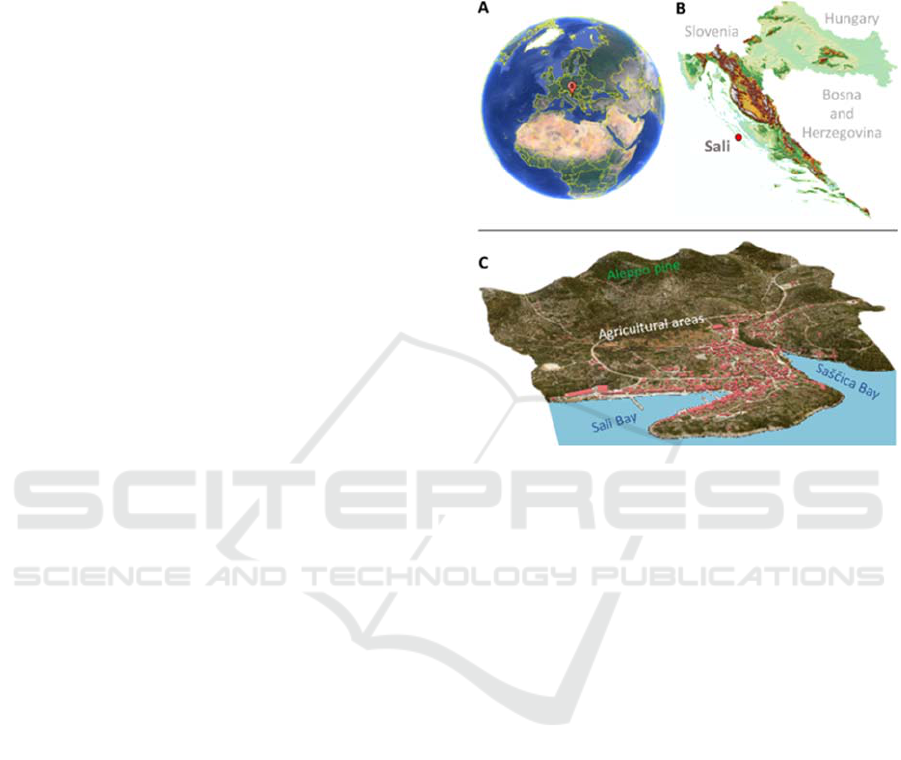
2 STUDY AREA
The study area (235 ha) includes drainage basins of
the Sali and Sašćica bays located in the settlement
Sali (Dugi Otok island, Croatia) (Fig. 1C). This
landscape is dominated by abandoned agricultural
(dominance of olive groves) areas with Aleppo pine
forests and predominantly degraded holm oak forests.
3 MATERIALS AND METHODS
3.1 GIS-MCDA
Wildfire ignition index was derived using
multicriteria GIS analysis (GIS-MCDA). The GIS-
MCDA process was performed in six steps which
included: (1) identification of problem and definition
of the main goal, (2) determination of criteria and
constraints, standardization of criteria (3),
determination of weight coefficients (ponders) (4),
criteria aggregation (5) and validation of created
model (6) (Fig. 2) (Malczewski and Rinner, 2015,
Domazetović et al., 2019).
Figure 1: Location of Sali settlement.
3.1.1 Selection of Evaluation Criteria
All predisposing criteria of fire ignition were
generated from the digital terrain model (DTM) and
multispectral orthomosaic produced from high-
resolution UAV imagery (Fig. 2). Four groups of
continuous values criteria and two (boolean) criteria
were used in the GIS-MCDA. These groups were (1)
morphometric (slope, elevation, aspect, terrain
ruggedness, topographic wetness index - TWI); (2)
vegetation (land cover, normalized difference
vegetation index - NDVI); (3) climate (insolation,
heat load index - HLI); and (4) anthropogenic
(distance from a road, distance from housing units)
(Fig. 2).
Aspect affects the amount of sunlight the area
receives and temperature. The study area is located in
the northern hemisphere therefore southern slopes
receive more sunlight. Elevation as an important
physiographic variable affects the volume of rainfall,
air humidity, vegetation patterns, and exposure to
wind (Tiwari et al., 2021). Fire ignitions at higher
elevations are generally less frequent due to lower
temperatures and higher rainfall. Most wildfires occur
on slopes between 0 and 20º. It has been found that
the rate of wildfire ignition decreases with a higher
slope (Swanson, 2018). Also, fire ignitions are more
Derivation of Wildfire Ignition Index using GIS-MCDA from High-Resolution UAV Imagery Data and Perception Analysis in Settlement
Sali, Dugi Otok Island (Croatia)
91
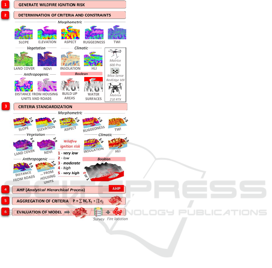
Figure 2: Methodological framework of wildfire ignition
index generation using MCDA-GIS.
frequent at less complex (ruggedness) terrain. The
topographic wetness index (TWI) is a measure of
long-term moisture that uses the upslope contributing
areas and slope to determine an index of moisture
(Iverson et al., 2004). Higher values mean more
tendency of an area to accumulate water (Mattivi et
al., 2019) therefore these areas have a lower risk of
wildfire ignition. Land cover is the key factor in the
ignition of wildfire (Carmo et al., 2011). In a
Mediterranean wildfire, risk should be higher for
shrublands, pine stands and, grasslands than
croplands and broadleaf forests. Normalized
difference vegetation index (NDVI) can indicate
higher vegetation dryness due to water stress which is
a predisposing factor for fire occurrence (Maselli et
al., 2003). Decreased values of NDVI in the
Mediterranean can be linked to a higher probability
of fire ignition during summer (Zipoli et al., 2000).
Most fires are caused by human-related causes.
Therefore, a closer distance from roads and housing
units is linked to higher a probability of fire ignition
(Gigović et al., 2018). The heat load index (HLI) is a
parameter that takes into account the steepness of the
slope when calculating the amount of solar radiation
received by the slope. Area solar radiation tool was
used to calculate the insolation across a study area. In
both parameters, higher values indicate a higher risk
of fire ignition. Using the geographic object-based
image analysis (GEOBIA), built-up areas (I) and
water surfaces (II) were extracted and used as (5)
boolean criteria. These criteria represent the areas
where wildfire can't occur.
3.1.2 Production of Digital High-Resolution
Terrain Model (DTM) and
Multispectral Orthomosaic Model
First, the high-resolution digital surface model was
derived from aerial images collected with the
unmanned aerial vehicle (UAV) (Matrice 210 RTK +
Zenmuse X7-16mm) (Fig. 3
1.1
). The flight was
performed in the DJI GSPro application. Aerial
imagery was acquired using the double grid mission
with front and side overlap of 80% (Fig. 3
1.2
). The
flying height was around 200 m. Camera self-
calibration was done in Agisoft Metashape 1.5.1. The
image workflow process was done in five steps: (1)
orientation of aerial imagery; (2) addition of ground
control points (GCP); (3) creation of a dense cloud;
(4) creation of a digital surface model (DSM); and (5)
creation of a digital orthophoto (DOP). A total of 10
GCP were collected with the GNSS device Stonex
S10 (Fig. 3
1.3
). Total RMSE of GCP was 4.3 cm.
Since the terrain characteristics are important for
deriving the criteria the final step involved generating
a digital terrain model (DTM) through correction and
filtering of the DSM. A correction was performed
using the DSM2DTM algorithm (Chirico et al., 2020)
which gradually removes anthropogenic and natural
elements elevated above the bare ground and
smoothes the final model by removing surface
irregularities (Fig. 4).
Multispectral orthomosaic was derived from
aerial images collected with UAV DJI Matrice
600Pro on which a Red Edge-Mica SenseMX camera
was mounted (Fig. 4). Radiometric calibration of the
multispectral camera using a calibrated reflectance
panel (CRP) was done before and after each mission.
GISTAM 2021 - 7th International Conference on Geographical Information Systems Theory, Applications and Management
92
Figure 3: Derivation of DSM and multispectral orthomosaic
model.
Figure 4: Conversion of DSM in DTM.
3.1.3 Standardization of Criteria
Standardization of criteria was conducted so their
mutual comparison on the same numerical scale
would be possible (Malczewski and Rinner, 2015).
Standardization was performed with a numerical
interval from 1 to 5 where class (1) referred to very
low ignition risk, (2) low, (3) moderate, (4) high, and
(5) very high. The criteria were standardized by
combining two methods. The decision-maker
standardization method (Domazetović et al., 2019)
was used for criteria that were used in similar case
studies. Jenks (natural breaks) classification method
was used to optimize the arrangement of a set of
values into "natural" classes for criteria where it is
difficult to accurately determine class boundaries to
the risk of a wildfire ignition risk.
3.1.4 Analytical Hierarchy Process (AHP)
Determination of weighting coefficients (Table 1)
was performed using the AHP, which ranks the
selected criteria according to their importance, i.e. the
level of influence on the decision or model. The
criteria were compared based on a scale of absolute
values that represent the extent to which one criterion
dominates over the other (Saaty, 2001). Furthermore,
a wildfire risk model has been created where all
criteria have the same weighting factor.
Table 1: Weighting coefficients (Woc) for wildfire ignition
predisposing criteria.
1234567 8 9 10 11Woc
1 1 2 3 3 4 4 5 5 6 7 1 0.26
20.50 1 2 2 3 3 4 4 5 6 0.500.18
3 0.33 0.50 1 1 2 2 3 3 4 5 0.330.12
4 0.33 0.50 1 1 2 2 3 3 4 5 0.330.12
5 0.25 0.33 0.50 0.50 1 1 2 2 3 4 0.250.08
6 0.25 0.33 0.50 0.50 1 1 2 2 3 4 0.25 0.08
7 0.20 0.25 0.33 0.33 0.50 0.5 1 1 2 3 0.200.05
8 0.20 0.25 0.33 0.33 0.50 0.5 1 1 2 3 0.200.05
9 0.17 0.20 0.25 0.25 0.33 0.33 0.50 0.50 1 2 0.17 0.03
10 0.14 0.17 0.20 0.20 0.25 0.25 0.33 0.33 0.50 1.00 0.14 0.02
11 0.11 0.13 0.14 0.14 0.17 0.17 0.25 0.25 0.33 0.50 0.11 0.02
1 - land cover, 2 - distance from roads, 3 - aspect, 4 - area solar
insolation, 5 - distance from housing unit. 6 - NDVI, 7 - HLI, 8 -
slope, 9 - elevation, 10 - TWI, 11 – ruggedness
3.2 Collection of Vegetation Data
After multispectral orthomosaic production, the field
(in-situ) vegetation samples were collected. Samples
were acquired to make easier identification of
vegetation species and to facilitate the process of
deriving the land cover (LC) model. Samples were
Derivation of Wildfire Ignition Index using GIS-MCDA from High-Resolution UAV Imagery Data and Perception Analysis in Settlement
Sali, Dugi Otok Island (Croatia)
93
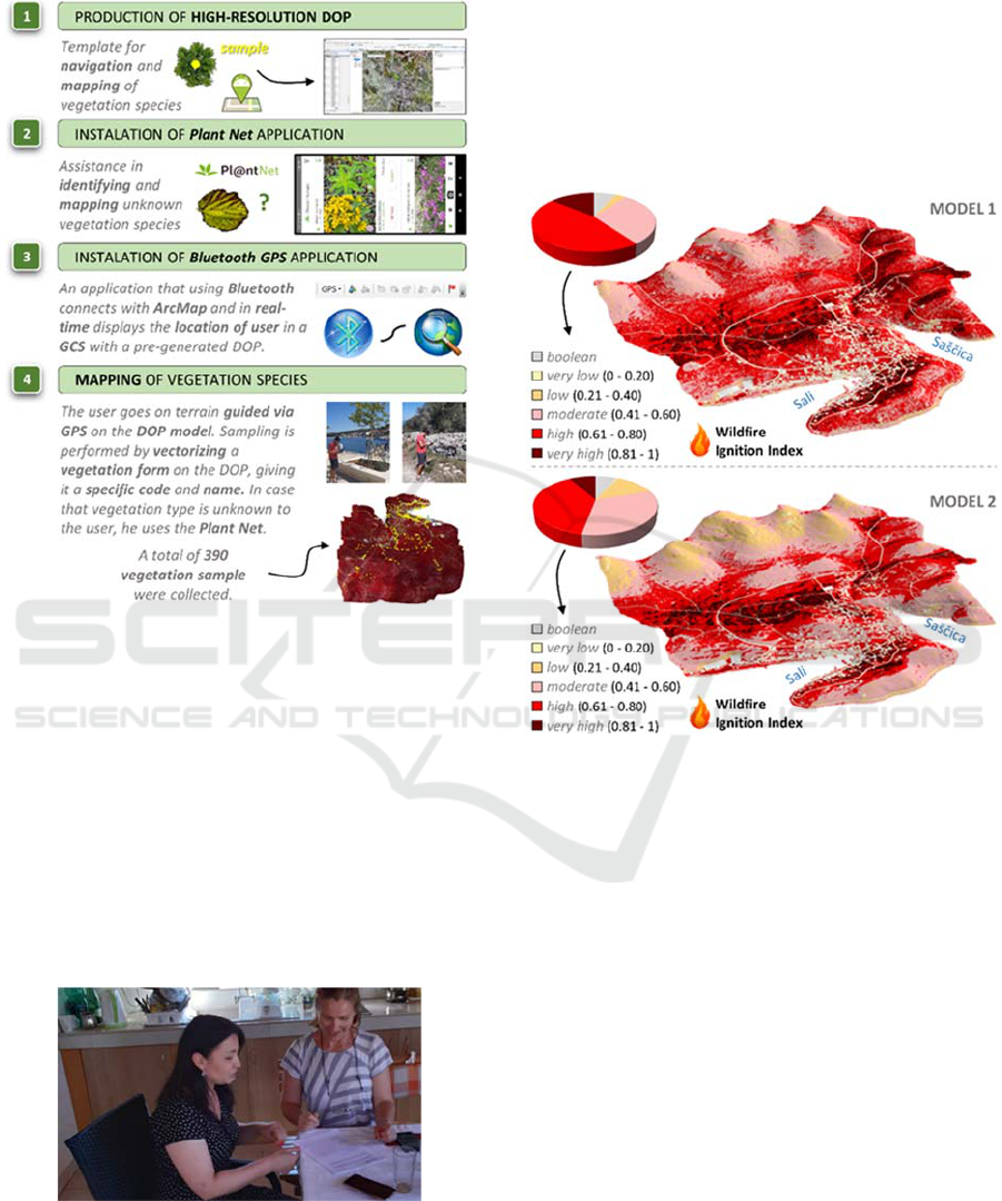
collected with a process divided into four steps (Fig.
5). A total of 390 samples were collected.
Figure 5: Methodological framework for collection of
vegetation type data.
3.3 Wildfire Perception Analysis
The questionnaire was conducted in the period from
25 to 30 June 2020. It involved 38 respondents, which
is 5% of the Sali population. In the project, the degree
of potential 33 threats (including wildfire) to the
natural environment was examined. Each
questionnaire was conducted at a different address
(Fig. 6). The type of sample was stratified, and the
selection was random. Only adult citizens were
selected.
Figure 6: Surveying respondents in Sali.
4 RESULTS AND DISCUSSION
4.1 Wildfire Ignition Index Models
Two models of ignition index have been derived (Fig.
7). In the first model weight coefficients were
determined by the AHP method (Table 1). In the
second model, all defined predisposing criteria had
equal weighting coefficients (0.091).
Figure 7: Derived models of wildfire ignition index.
In both cases, the models were classified using the
equal interval method. The share of risk classes in the
total studied area was calculated. In model 1, very
high (5) and high (4) classes occupy almost 60% of
the total area. The most risk area includes the
neglected agricultural area and evergreen vegetation
near the roads. In model 2, very high (5) and high (4)
classes include 47% of the total area. However, the
areas of the highest risk of fire ignition generally
coincide with the first model.
Vegetation cover, dominated by Aleppo pine,
maquis, other shrublands, and neglected agricultural
areas, combined with other predisposing factors make
the wider area of Sali very risky from fire ignition.
This is not surprising given that the Dalmatian coast
and islands are classified as the most endangered
areas of wildfire ignition in HR. Therefore, we
believe that the proposed framework, with minor
modifications, can be applied in other Mediterranean
countries that have a high risk of wildfires.
GISTAM 2021 - 7th International Conference on Geographical Information Systems Theory, Applications and Management
94
4.2 Proposed Measures for Wildfire
Prevention
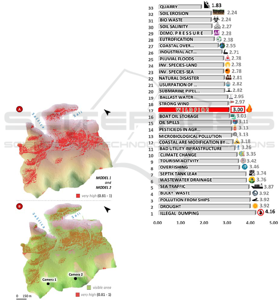
A system of surveillance cameras has been proposed
with the aim of preventing and timely detection of
wildfires. Within the study area, a binary visibility
analysis was performed at two proposed locations
where cameras could monitor very high risk (class 5)
areas of wildfire ignition. In total, (model 1 + model
2) 39.21 ha of the study area has a very high risk of
wildfire ignition (Fig. 8A).
The camera at a height of 10 m and the range of
surveillance with a radius of 2 km was assumed. The
installed cameras could monitor an area of 114.58 ha,
of which 38.21 ha falls into the category of the very
high risk (Fig. 8B), which means that 97.45% of this
surface could be monitored from proposed locations.
Other measures are also proposed: raising the
level of awareness about the dangers of wildfire;
revitalization of abandoned and neglected
agricultural plots; thinning and cleaning of forests and
construction of narrow, cleared paths to achieve
easier movement in the terrain in the event of a
wildfire spreading.
Figure 8: Coverage of very high (5) wildfire ignition risk
area with surveillance camera.
4.3 Results of Risk Perception Analysis
The average age of 38 respondents was 41.36 years.
In comparison to all analyzed threats to the natural
environment of the settlement Sali, respondents
(n=38) have evaluated the risk of wildfire ignition in
17th place out of 33 analyzed threats (Fig. 9).
Respondents have rated the risk of wildfire ignition
as moderate (3.00), while the standard deviation in
responses was 1.16.
Figure 9: Perceptions of the threats to the natural
environment of the Sali wider area.
Since official data about the historical location of
wildfires in Sali settlement do not exist, respondents
have detected recent locations of wildfires on the
generated high-resolution DOP. It is necessary to
point out that this is the main drawback of the
research. Namely, there is a lack of wildfire
occurrence data to accurately validate the model.
Respondents were able to detect only a few recent
wildfires. The difference between the models is
Derivation of Wildfire Ignition Index using GIS-MCDA from High-Resolution UAV Imagery Data and Perception Analysis in Settlement
Sali, Dugi Otok Island (Croatia)
95

difficult to determine since in both models all wildfire
ignition locations are located within (4) high or very
(5) high-risk classes. (Fig. 10).
Figure 10: Detected locations of wildfire ignition.
5 CONCLUSION
High-resolution UAV imagery (RGB and
multispectral) and GIS-MCDA were used to derive a
wildfire ignition index. The wider area of Sali
settlement can be considered as a high-risk area for
wildfire ignition. Risk perception analysis showed
that the respondents perceived wildfires as a moderate
(x ̅=3.00) threat to their natural environment. A set of
specific measures (surveillance cameras, forest
thinning, etc.) has been proposed to prevent wildfire
ignition. In future research, the presented
methodology framework will be applied to a larger
study area. The GIS-MCDA will be expanded with
additional criteria (e.g. power lines, landfill sites)
depending on the characteristics of the study area.
Also, more wildfire occurrence data will be collected
for model validation.
ACKNOWLEDGEMENTS
This work has been supported by INTERREG
PEPSEA project and Croatian Science Foundation
under the project UIP-2017-05-2694.
REFERENCES
Ajin, R. S., Loghin, A. M., Jacob, M. K., Vinod, P. G., &
Krishnamurthy, R. R. (2016). The risk assessment study
of potential forest fire in Idukki Wildlife Sanctuary
using RS and GIS techniques. International Journal of
Advanced Earth Science and Engineering, 5(1), 308-
318.
Bonazountas, M., Kallidromitou, D., Kassomenos, P. A., &
Passas, N. (2005). Forest fire risk analysis. Human and
Ecological Risk Assessment, 11(3), 617-626.
Carmo, M., Moreira, F., Casimiro, P., & Vaz, P. (2011).
Land use and topography influences on wildfire
occurrence in northern Portugal. Landscape and Urban
Planning, 100(1-2), 169-176.
Catry, F. X., Rego, F. C., Bação, F. L., & Moreira, F. (2010).
Modeling and mapping wildfire ignition risk in
Portugal. International Journal of Wildland Fire, 18(8),
921-931.
Chirico, P. G., Bergstresser, S. E., DeWitt, J. D., & Alessi,
M. A. (2020). Geomorphological mapping and
anthropogenic landform change in an urbanizing
watershed using structure-from-motion
photogrammetry and geospatial modeling techniques.
Journal of Maps, 1-12.
Domazetović, F., Šiljeg, A., Lončar, N., & Marić, I. (2019).
Development of automated multicriteria GIS analysis
of gully erosion susceptibility. Applied geography, 112,
102083.
Doolin, D. M., & Sitar, N. (2005, May). Wireless sensors
for wildfire monitoring. In Smart Structures and
Materials 2005: Sensors and Smart Structures
Technologies for Civil, Mechanical, and Aerospace
Systems (Vol. 5765, pp. 477-484). International
Society for Optics and Photonics.
Eskandari, S. (2017). A new approach for forest fire risk
modeling using fuzzy AHP and GIS in Hyrcanian
forests of Iran. Arabian Journal of Geosciences, 10(8),
190.
Gigović, L., Jakovljević, G., Sekulović, D., & Regodić, M.
(2018). GIS multi-criteria analysis for identifying and
mapping forest fire hazard: Nevesinje, Bosnia and
Herzegovina. Tehnički vjesnik, 25(3), 891-897.
Hefeeda, M., & Bagheri, M. (2007, October). Wireless
sensor networks for early detection of forest fires. In
2007 IEEE International Conference on Mobile Adhoc
and Sensor Systems (pp. 1-6). IEEE.
Iverson, L. R., Prasad, A. M., & Rebbeck, J. (2004). A
comparison of the integrated moisture index and the
topographic wetness index as related to two years of
soil moisture monitoring in Zaleski State Forest, Ohio.
In: Yaussy, Daniel A.; Hix, David M.; Long, Robert P.;
Goebel, P. Charles, eds. Proceedings, 14th Central
Hardwood Forest Conference; 2004 March 16-19;
Wooster, OH. Gen. Tech. Rep. NE-316. Newtown
Square, PA: US Department of Agriculture, Forest
Service, Northeastern Research Station: 515-517.
Malczewski, J., & Rinner, C. (2015). Multicriteria decision
analysis in geographic information science (pp. 220-
228). New York: Springer.
Maselli, F., Romanelli, S., Bottai, L., & Zipoli, G. (2003).
Use of NOAA-AVHRR NDVI images for the
estimation of dynamic fire risk in Mediterranean areas.
Remote Sensing of Environment, 86(2), 187-197.
Mattivi, P., Franci, F., Lambertini, A., & Bitelli, G. (2019).
TWI computation: a comparison of different open
source GISs. Open Geospatial Data, Software and
Standards, 4(1), 1-12.
GISTAM 2021 - 7th International Conference on Geographical Information Systems Theory, Applications and Management
96

Mohammadi, F., Shabanian, N., Pourhashemi, M., & Fatehi,
P. (2010). Risk zone mapping of forest fire using GIS
and AHP in a part of Paveh forests. Iranian Journal of
Forest and Poplar Research, 18(4), 569-586.
Pavlek, K., Bišćević, F., Furčić, P., Grđan, A., Gugić, V.,
Malešić, N., Moharić, P., Vragović, V., Fuerst-Bjeliš,
B., & Cvitanović, M. (2017). Spatial patterns and
drivers of fire occurrence in a Mediterranean
environment: a case study of southern Croatia.
Geografisk Tidsskrift-Danish Journal of Geography,
117(1), 22-35.
Pausas, J. G., Alessio, G. A., Moreira, B., & Segarra-
Moragues, J. G. (2016). Secondary compounds enhance
flammability in a Mediterranean plant. Oecologia,
180(1), 103-110.
Roland, V., Marić, I., & Milošević, R. (2015). Application
of GIS technology in firefighting. Vatrogastvo i
upravljanje požarima, (1.), 57-71.
Saaty, T. L. (2001). Fundamentals of the analytic hierarchy
process. In The analytic hierarchy process in natural
resource and environmental decision making (pp. 15-
35). Springer, Dordrecht.
Sebastián-López, A., Salvador-Civil, R., Gonzalo-Jiménez,
J., & SanMiguel-Ayanz, J. (2008). Integration of socio-
economic and environmental variables for modelling
long-term fire danger in Southern Europe. European
Journal of Forest Research, 127(2), 149-163.
Sharma, L. K., Kanga, S., Nathawat, M. S., Sinha, S., &
Pandey, P. C. (2012). Fuzzy AHP for forest fire risk
modeling. Disaster Prevention and Management: An
International Journal.
Somashekar, R. K., Ravikumar, P., Kumar, C. M., Prakash,
K. L., & Nagaraja, B. C. (2009). Burnt area mapping of
Bandipur National Park, India using IRS 1C/1D LISS
III data. Journal of the Indian Society of Remote
Sensing, 37(1), 37-50.
Stipaničev, D., Hrastnik, B., & Vujčić, R. (2007, May).
Holistic Approach to Forest Fire Protection in Split and
Dalmatia County of Croatia, Wildfire 2007 Int. In
Conference, Sevilla, Spain.
Swanson, V. (2018). Fire Ignition and Burn Risk: A Study
in Trinity and Los Angeles Counties in California.
Thompson, M. P., & Calkin, D. E. (2011). Uncertainty and
risk in wildland fire management: a review. Journal of
environmental management, 92(8), 1895-1909.
Tiwari, A., Shoab, M., & Dixit, A. (2021). GIS-based forest
fire susceptibility modeling in Pauri Garhwal, India: a
comparative assessment of frequency ratio, analytic
hierarchy process and fuzzy modeling techniques.
Natural Hazards, 105(2), 1189-1230.
Vasilakos, C., Kalabokidis, K., Hatzopoulos, J., Kallos, G.,
& Matsinos, Y. (2007). Integrating new methods and
tools in fire danger rating. International Journal of
Wildland Fire, 16(3), 306-316.
Vescoukis, V., Doulamis, N., & Karagiorgou, S. (2012). A
service oriented architecture for decision support
systems in environmental crisis management. Future
generation computer systems, 28(3), 593-604.
Zipoli, G., Costantini, R., Romanelli, S., Bottai, L., &
Maselli, F. (2000). Use of satellite and ancillary data for
the evaluation of structural and meteorological forest
fire risks in Tuscany (Central Italy). In Proceedings of
ECAC.
Derivation of Wildfire Ignition Index using GIS-MCDA from High-Resolution UAV Imagery Data and Perception Analysis in Settlement
Sali, Dugi Otok Island (Croatia)
97
