
Use of Machine Learning for Expanding Realistic and Usable Routes for
Data Analysis on Sustainable Mobility
Fabian Schirmer
a
, Andreas Freymann
b
, Anamaria Cristescu
c
and Niklas Geisinger
d
Fraunhofer IAO, KEIM, Esslingen, Germany
Keywords:
Neuronal Networks, Cloaking, Data Protection, Location Data, Mobility, Machine Learning.
Abstract:
The current mobility or the transition to more sustainable alternatives are constantly changing. For Promoting
a sustainable mobility and for investing in a proper infrastructure, we need accurate data regarding the mo-
bility behavior. Gathering location information such as GPS can help to improve the charging infrastructure
and the bicycle or pedestrian paths. This motivates the citizens to use sustainable means of transportation such
as bicycles or electric cars. However, using personal information via GPS data can cause some challenges:
preserving data privacy while keeping data quality to get useful analysis results. This paper presents an ad-
vanced approach of processing GPS data based on machine learning and spatial cloaking in contrast to current
approaches focusing on common algorithms only. The evaluation has been conducted by generating simulated
GPS trips. As a result, the presented approach provides an algorithm that prevents a complete loss of useful
data while protecting the privacy of each user in cases where cloaking areas are close together.
1 INTRODUCTION
One of the biggest challenges that governments must
face worldwide, is to achieve the Paris Agreement
goals, which demand to keep the temperature below
2°C and reduce emissions (Pan et al., 2017). The
transport sector is a crucial intervention field since
it plays a main role in global carbon emission (Ort-
meyer and Pillay, 2001). In fact, almost 85% of trans-
port emissions can be assigned to road travel (Ritchie,
2020). In Germany, sustainability of the transport sec-
tor has become a major concern of the government
(Merkel, 2018). Germany is one of the most motor-
ized countries globally, where the private usage of the
car is up to 43% due to the total number of trips (Bun-
desministerium f
¨
ur Verkehr und digitale Infrastruktur,
2020). As an example, Chemnitz, a German city, is
no exception, where the private usage of a car is be-
ing a preferred mode of transport (Chemnitz, Stadt der
Moderne, 2020).
Promoting sustainable development in the trans-
port sector is, therefore, an essential topic for science
as well. According to a recent research on transporta-
a
https://orcid.org/0000-0002-7032-8242
b
https://orcid.org/0000-0002-3735-4545
c
https://orcid.org/0000-0002-5299-1972
d
https://orcid.org/0000-0003-0224-8213
tion planning measures, a better infrastructure can
motivate citizens to swift to more sustainable modes
of transport which comprises, e.g., separated bicycle
paths increase passengers’ readiness to use the bicy-
cle up to 55% (Wardman, 2007). (Martens, 2007)
demonstrates that high-quality cycling infrastructure
increases bike-and-ride mobility behavior. This im-
plies that satisfaction with the urban mobility infras-
tructure is crucial for shifting to sustainable modes
of transport, such as public transport, walking, or cy-
cling. Therefore, this requires further studies on pas-
sengers ‘mobility behavior and needs, if we want to
design the infrastructure that facilitates the transport
mode shift effectively.
The city of Chemnitz recently launched the
project New Urban Awareness of Mobility in Chem-
nitz (NUMIC) to address the issue of mobility shift
(Chemnitz, Stadt der Moderne, 2020). Within this
project, a smartphone application has been developed
to track trips of the citizens of Chemnitz via GPS. By
sharing the GPS information of their trips, the citizens
can contribute to the understanding of the mobility
behavior patterns, which would help to increase the
sustainability of the mobility infrastructure. GPS data
collection has become a popular method for the evalu-
ation of mobility behavior (Niu et al., 2014). Such ap-
proach can be used to connect the information about
the infrastructure with specific location data. Another
156
Schirmer, F., Freymann, A., Cristescu, A. and Geisinger, N.
Use of Machine Learning for Expanding Realistic and Usable Routes for Data Analysis on Sustainable Mobility.
DOI: 10.5220/0010395201560163
In Proceedings of the 6th International Conference on Internet of Things, Big Data and Security (IoTBDS 2021), pages 156-163
ISBN: 978-989-758-504-3
Copyright
c
2021 by SCITEPRESS – Science and Technology Publications, Lda. All rights reserved

feature of the application is that the user can make
suggestions for the infrastructure improvements for
an exact GPS location. The tracking of the entire trip
and the location-based notifications can then be used
to analyze the mobility behavior and needs. Based
on the results, planners can improve and develop the
existing mobility infrastructure. However, the main
challenge in this context is to ensure the data privacy
because tracking of GPS trips usually comprises im-
portant personal information. A possible data protec-
tion solution is to reduce the precision of the GPS
trips, which can be done by cloaking the start point
and end point of each trip. This is done by stan-
dard cloaking algorithms that replace GPS informa-
tion of the trips within a specific area. This solution
prevents the possibility of extracting personal infor-
mation, and as a result, it does not allow the identifi-
cation of a tracked person. However, even if the use
of this standard cloaking algorithm protects the pri-
vacy, it inevitably leads to the loss of the most relevant
GPS data. This paper presents an advanced approach
that preserves relevant information of such GPS trips
while simultaneously ensures the data protection and
privacy of each tracked person. This approach sug-
gests an algorithm, which expands GPS data points of
a trip into another free defined cloaking areas to blur
the start and the end of a trip. We call this algorithm
Expanded Cloaking Algorithm (EXCL-Algorithm).
We applied this algorithm to two specific scenarios
to demonstrate that this algorithm maintains relevant
data while ensuring data privacy. In the upcoming
chapters, we describe these evaluation scenarios. The
paper is structured as follows. Section 2 focuses on
the related publications and provides insights into rel-
evant topics, including cloaking algorithms and data
privacy. Section 3 describes the problem scenarios in-
cluding the use of a standard cloaking algorithm. The
privacy conditions are explained in section 4. Section
5 presents the solution to cloak the GPS tracks based
on EXCL-Algorithm. Section 6 summarizes the re-
sults and outcomes of the suggested solution and, fi-
nally, Section 7 closes this paper by providing the
conclusion and an outlook on future work.
2 RELATED WORK
Tracking has become a prominent IT field, which
comprises various technologies and methods devel-
oped to date. Especially widespread is the usage
of location-based data in our daily life (Zhu et al.,
2013). However, the data protection associated with
tracking has become a controversial topic since GPS
data can reveal highly personal information(Trujillo-
Rasua and Domingo-Ferrer, 2015; Feng and Timmer-
mans, 2017). This poses a challenge for the develop-
ers of tracking services because the data needed for
the analysis has, in many cases, to be protected. In
the case of the NUMIC project, the mobility track-
ing application requires sensitive data on commuters’
daily routes to analyze the mobility patterns and in-
frastructure deficiencies; some parts of this data must
be protected to avoid identifying the persons who par-
ticipate. This section discusses several common ap-
proaches to data privacy protection, namely data ag-
gregation, k-anonymity, cloaking and extension.
Data aggregation brings some information to a
higher level by removing specific identifiers. How-
ever, a well-known weakness of this approach is that
specific information can be re-identified, e.g. by en-
riching aggregations with other data (Sweeney, 2012).
This approach moves the users’ identity away
from the original position (Zhu et al., 2013). Clau-
dio et al. (2005) address this issue in the context
of location-based services (i.e. navigation services
for weather forecasting or location-based marketing),
which represent sensitive private information. Their
research contribution regards a framework that evalu-
ates the risk of using pseudonyms to protect sensitive
data and presents using k-anonymity as a more secure
approach. Niu et al. (2014) use the k-anonymity for
location-based services to increase privacy by offer-
ing an algorithm based on dummy locations. The re-
sult also shows an increase in protecting the privacy
level. However, the probability that all persons have
similar sensitive data increases if data from many per-
sons are collected. In that case, the k-anonymity lacks
in anonymity (Claudio et al., 2005). In the specific
case described in this paper, k-anonymity is not an
appropriate approach since it is not determinable how
many users participate. Since the number of app users
in the NUMIC project is not estimable, this approach
is for the evaluation of the collected data not suitable.
Another technique to protect data privacy is spa-
tial cloaking (Jeansoulin et al., 2010; Chow and Mok-
bel, 2011), which is also acknowledged in the context
of location-based services (Wang and Wang, 2010).
Chow et al. (2011) describe a common approach that
blurs sensitive information into a cloaking area. They
contribute to it by offering a spatial cloaking algo-
rithm designed for mobile peer-2-peer environments,
which can increase the scalability, privacy protection,
and effectiveness of the algorithm. Ghinita et al. (Gh-
inita et al., 2007) go one step further and present a
distributed architecture for anonymous location-based
queries, which should fill in the gap of existing solu-
tions. They claim, for example, that centralized so-
lutions cause a bottleneck related to the amount of
Use of Machine Learning for Expanding Realistic and Usable Routes for Data Analysis on Sustainable Mobility
157
location-based queries. Furthermore, Wang and Wang
(2010) also claim that traditional spatial cloaking ap-
proaches lack a central service where all information
comes together. Thus, they address an in-device spa-
tial cloaking and propose using cloud service to get
relevant information on the cloak region
The literature review leads us to a central
dilemma: the necessary data protection automati-
cally causes a greater inaccuracy of the GPS data,
which in turn decreases the informative value of the
data. Hohet al. addressed this issue by presenting
an uncertainty-aware path cloaking algorithm using a
novel time-to-confusion metric in the context of GPS
trips of vehicles (Hoh et al., 2007).
Similarly, Scheider et al. (2020) displayed and ex-
amined a strategy to obfuscate GPS trips by extending
the trip. In addition, they introduced a method for
simulated crowding. These methods have numerous
advantages, but also a few disadvantages. Firstly, the
length of a trip increases by 50%. Secondly, it re-
quires more than a doubled runtime.
Thus, this paper builds on the research findings
of Scheider et al. (2020) and adds the spatial cloak-
ing (Wang and Wang, 2010) to eliminate disadvan-
tages of each algorithm. The spatial cloaking by itself
deletes significant GPS data needed for further anal-
ysis, whereas the simulated crowding in the study of
Scheider et al. produces too much unrealistic data (?).
However, the combination of these two methods out-
weighs their disadvantages.
3 PROBLEM DEFINITION
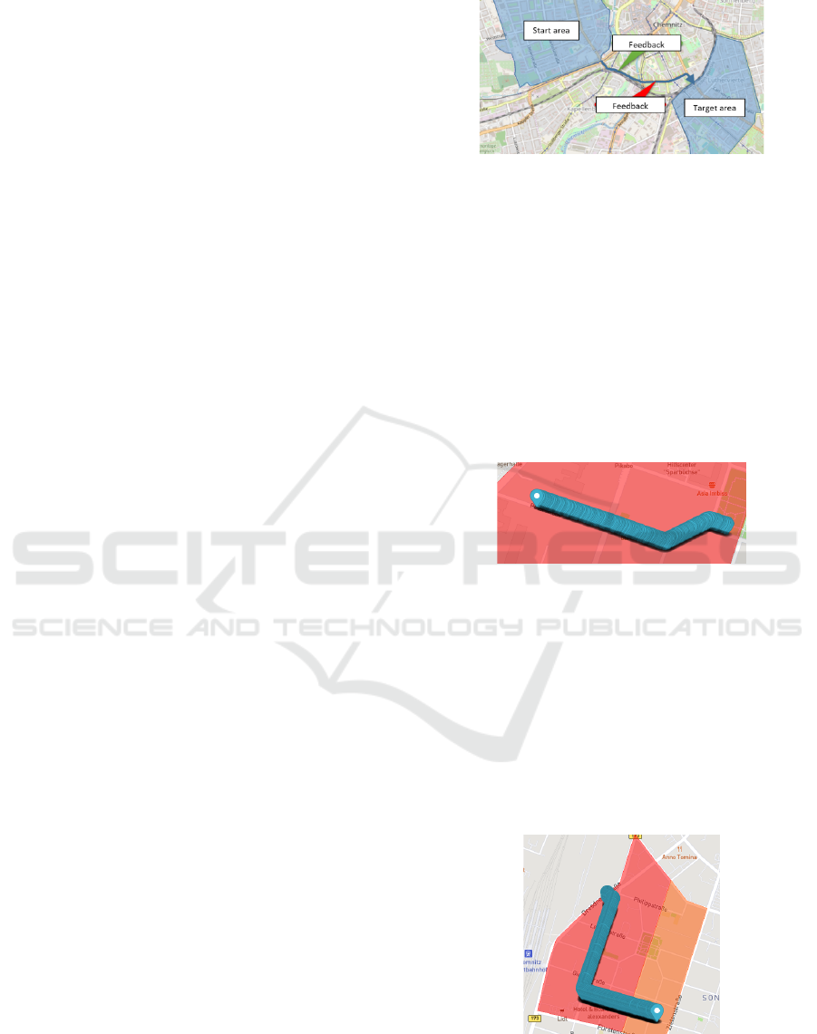
Figure 1 shows a running example of how a com-
mon spatial cloaking can be applied. It illustrates a
GPS trip between a start and a target area in the city
of Chemnitz, Germany. Additionally, Feedback mes-
sages from the user can be added to the trip. While
the path between these two areas is visible, the exact
GPS points within the start area and target area have
been blurred out (i.e., GPS points have been deleted)
into cloak regions. This deletion generally enables the
privacy protection of a user who uses, for example,
a smartphone application to record a trip. The start
and target points of the trip are not determinable any-
more. This makes it impossible for an outsider to map
the trip to a home, a working place, or other visited
places of a specific person. However, the main trip
between the start and the target area has been main-
tained, which can be used to connect a text message
to a specific location on the path.
The size of each cloaking area depends on the
population density. Large cloaking areas represent the
Figure 1: Spatial cloaking.
urban areas with a lower population density, whereas
small cloaking areas represent the urban areas with
a higher population density. The described scenario
shows a common way to use cloaking. However, in
some specific scenarios that can occur in this context,
the start and target points might be too close to each
other. Based on the use of the standard cloaking algo-
rithm, this results in a vast loss of GPS data or even
in a deletion of the entire trip. Two scenarios can be
identified, which are affected by the described prob-
lem of being to close to each other. They will be de-
scribed in the following.
Figure 2: Scenario one: One area.
Scenario One - One Area: In some cases, especially
for short trips, there is a high probability that the start
and target points of a trip lie within a single cloak-
ing area. More precisely, the start point and the target
point of the trip would be the same and are respec-
tively congruent (see Figure 2). If we use the com-
mon cloaking algorithm and the user remains in this
cloaking area, all data points would be deleted, and
no GPS data points would lie between these two ar-
eas. The only information left is the red area.
Figure 3: Scenario two: bordering areas.
Scenario Two - Areas Adjoin Each Other: Another
scenario is when the start point and the target point
IoTBDS 2021 - 6th International Conference on Internet of Things, Big Data and Security
158

lie in different cloaking areas, but these areas are di-
rectly adjoined to each other as it is shown in Figure
3. Similar to Scenario one, there would be no GPS
data points between these two areas since all the data
points would be deleted by the common cloaking al-
gorithm. As a result, the important analysis could not
be performed. Since two areas replace the tracked
GPS data, more data is lost.
For both mentioned reasons, we created a unique
cloaking algorithm (EXCL-Algorithm) to handle such
situations by preserving GPS data as well as protect-
ing the privacy.
4 PRIVACY CONDITIONS
For training and testing the EXCL-Algorithm, GPS
trips were generated through the method of simula-
tion by considering the data protection regulations.
We used the open source software tool SUMO (Sim-
ulation of Urban MObility) (Sumo, 2020) since it en-
ables to create realistic GPS trips. This includes for
example, waiting times due to traffic lights or multi-
modal traffic (using a combination of several different
modes of transportation). Finally, this tool enables to
test different modes of transportation as well as to test
the plausibility of such generated and expanded trips.
For the simulation of GPS trips, two random adja-
cent areas within the city of Chemnitz have been cho-
sen. The map data is retrieved from OpenStreetMap
(OSM) and imported into the SUMO model. For sce-
nario one, one single area is used, whereas in scenario
two, two cloaking areas lie directly next to each other.
For each of those two scenarios, 20 trips simulated by
SUMO are used. Several irregular trips have also been
included in the scenarios (e.g., trips that start or end in
dead-end roads) in order to verify the algorithm even
for such complex cases. Furthermore, each scenario
comprises ten trips simulated by vehicles and ten trips
simulated by pedestrians as they pass parks and other
pedestrian-only areas. The routes of the trips have
various lengths, ranging from 24 meters in scenario
one to 973 meters in scenario two.
With specifying the trips as input for SUMO, the
simulation results, finally, comprises the position of
each vehicle or pedestrian. To obtain realistic GPS
trips, the exported data is then thinned out to only in-
clude data points with a random distance between 0.5
and 3 meters to each other, which results in having
between 15 to 632 data points per trip. These differ-
ent distances reflect the stop-and-go behavior of each
user. Table 1 shows the average distance between
two consecutive data points (column: “Avg. dist.”),
the range of total length (column: “Length”), and the
number of data points (column: “Points”) of the trips
for the two scenarios, each further divided into car
(denoted as C) and pedestrian routes (denoted as P).
Table 1: Overview of the simulated data.
Scenario Length Points Avg. dist.
One (C) 303 - 831 m 177 - 460 1.73 m
One (P) 24 - 692 m 15 - 365 1.54 m
Two (C) 135 - 870 m 79 - 367 1.72 m
Two (P) 52 - 973 m 36 - 632 1.53 m
5 SOLUTION APPROACH
As mentioned before, using the common cloaking ap-
proach for both presented scenarios, all data points
within the cloaking areas would be deleted. One the
one hand, this ensures data protection as it makes
it impossible to retrieve any information from the
trips anymore. On the other hand, detailed data anal-
ysis is impossible. This section presents the Ex-
panded Cloaking Algorithm (EXCL-Algorithm) that
preserves the single GPS data points while simultane-
ously preserving the data privacy.
One important characteristic of the EXCL-
Algorithm is the expansion of the available GPS trip
(red bubbles), which is shown in 4. For that, the
EXCL-Algorithm creates new cloaking areas (blue
rectangles) where new artificial start and target points
will be located. These artificial points are essen-
tial, because they expanse the original start and tar-
get points with artificial start and target points (green
bubbles) in order to blur the original start and target
points into just GPS points without having a starting
or ending character. This results in protecting private
information such as private addresses. In compari-
son to the common cloaking algorithm, which would
delete all original GPS data points (red bubbles), the
EXCL-Algorithm creates due to the additional arti-
ficial GPS data points (green bubbles) new artificial
cloaking areas (blue rectangles): start and target area.
As a result, the data points between these new two
areas can be maintained and used for further analy-
sis and studies. The protection of private data is also
granted, since the trip cannot be linked to a specific
person. Furthermore, the EXCL-Algorithm enables
that it is not apparent which data points are artificially
generated and which are real. The only information
about each of the GPS trips is that it was manipulated
by an expanded algorithm.
The cloaking of each GPS using the EXCL-
Algorithm is done in two directions: from the start
as well as from the target point of the trip. For that
Use of Machine Learning for Expanding Realistic and Usable Routes for Data Analysis on Sustainable Mobility
159
Figure 4: Scenario Two: Two areas.
a new artificial starting point as well as a target point
are generated by adding and expanding a new starting
and target cloaking area. Finally, both sides of each
GPS trip are then expanded until the origin cloaking
area (red area) is left. The new GPS track consists of
a new artificial start point and a new artificial target
point which both lie within a new and differing cloak-
ing area (blue rectangles). All GPS points within the
origin cloaking area are preserved.
Figure 5: Steps of the EXCL-Algorithm.
Figure 5 gives an overview of the main steps of
the EXCL-Algorithm explained in the respective sub-
section. Generally, the outcome of these steps are the
artificially generated GPS points of a trip. The first
step (S1) is responsible for generating new artificial
GPS data for the new cloaking areas with the help of
machine learning (see subsection 5.1). The result of
the first step will then be checked afterwards in step
two (S2) which checks the realistic trajectory and step
three (S3) which is responsible for checking the area
trajectory. If S1 or S2 fails, the previous step is active
again. The checking of S2 and S3 includes the check-
ing of the distance between each of the trajectories
and whether the original area is deleted (see subsec-
tion 5.2 and 5.3). The results are then added to the
start and to the target of the existing trip in the last
step 4 (S4), which enables the possibility to use the
whole trip for further data analysis.
5.1 Generating New GPS Data (S1)
Step S1 is responsible for generating new artificial
GPS data, which is essential to expand the original
trip into new defined cloaking areas. Generating new
GPS data in addition to the existing ones is done with
one of the machine learning algorithms of section
5.1.2. Thus, the following section deals, firstly, with
structuring of the input data, which is needed for the
machine learning algorithms and, secondly, with the
comparison of different machine learning algorithms.
5.1.1 Input Data
The input data (i.e., GPS data points from the orig-
inal GPS trip) is always different due to the differ-
ent length of each trip. Large areas may allow more
GPS data than in smaller areas. Moreover, it is im-
portant to consider the distances between the GPS
points. Due to the different modes of transportation,
distances from GPS points vary significantly. Regrad-
ing the training data, it is structured in a way that the
data point d(t) is used to estimate the next data point
d(t+1). This training method is used for the whole
GPS data. Figure 6 shows the procedure how the in-
put data is processed by the EXCL-Algorithm. The
black arrow on the upper side stands for the course of
the training.
Figure 6: Structuring the input data.
The last GPS point, which is represented by the
blue rectangle in Figure 6, is used for the first check of
the realistic trajectory to control the distance between
the GPS points in S2. Using this structure enables the
machine learning algorithm to get a meaning of the
overall trajectory.
5.1.2 Comparison of Different Machine
Learning Algorithms
Based on the above mentioned input data, differ-
ent machine learning algorithms (e.g., Neural Net-
works, Linear Regression, or Long Short-Term Mem-
ory) need to be trained and evaluated. The compar-
ison is done based on accuracy and realistic values
(S2 and S3). In addition, the amount of training data
is required to generate the GPS data points. For this
reason, different lengths are simulated, as shown in
Table 1. The machine learning algorithms are based
on supervised learning, where the training data repre-
sents the existing GPS data points. The decision of
appropriate output data of the algorithm is based on
checks of the approximately same distance between
the GPS data and the leaving of the original area.
For our EXCL-Algorithm we compare three ma-
chine learning algorithms for generating new GPS
data: Linear Regression (LR), neural network (NN)
and Long Short-Term Memory(LSTM). Table 2
IoTBDS 2021 - 6th International Conference on Internet of Things, Big Data and Security
160

shows these machine learning algorithms in terms of
their accuracy and duration of training in epochs. The
values in the table are based on the lowest amount of
training data. Increasing the training data will pro-
duce slightly better values for model accuracy and the
number of epochs needed for good results. Finally,
we picked the best training accuracy for the first try to
expand the existing trip.
Table 2: Overview machine learning.
Criterion LR NN LSTM
Model accuracy 10
−8
10
−8
10
−9
Epochs - 40 20
Each machine learning algorithm is equipped with
Early Stopping, which stops the training if the accu-
racy starts to increase.
Linear Regression. Linear Regression always pro-
duces well results for expanding each trip. Linear Re-
gression uses the method of least-squares, which is
the method of finding the best-fitting line for the train-
ing data by minimizing the sum of the squares of the
vertical deviations from each training point to the line.
(Seber and Lee, 2012, p. 35 ff.)
Neuronal Network. The general neural network
consists of an input-layer, one or more hidden lay-
ers, and an output layer. Each of the layers, in turn,
consists of neurons. (G
´
eron, 2018, p. 253 ff.)
n
∑
i=1
x
i
· w
i
(1)
Calculation of the neurons (G
´
eron, 2018, p. 253 ff.)
The output depends on the inputs x, weights w
(see equation 1), and the activation function for each
neuron. The activation function is linear. The opti-
mizer is Adam (a method of stochastic optimization)
and the loss function is mean squared error. This spe-
cific choice is based on the most accurate result for
the output of the model.
Long Short-Term Memory. One strength of the
Long Short-Term Memory (LSTM) is extracting use-
ful information about historical records. These cells
learn over a long-range dependency to forecast the
data. Most of the other algorithms still have prob-
lems with such a behavior. (Hua et al., 2019) We used
it in the following case to get a meaning of the whole
trajectory and predict realistic values. The optimizer
chosen is Adam and the loss function is mean squared
error.
5.2 Check Realistic Trajectory (S2)
After the artificially generating GPS points in S1, we
conducted the feasibility. The purpose of the first
check (S2) is to ensure that the generated GPS data
points are as realistic as possible (the distances be-
tween each of the GPS points are nearly the same). If
the first validation is successfully done the next step
S3 is checked. If not, the generation of new GPS
data points will generate a new GPS point. The GPS
data points should be generated in a realistic manner,
so that the generated GPS points should be close to
each other in the same way as the data given. This
means that the distances (d) between each GPS point
are nearly identically to the other points follow after-
wards (see equation 2).
d(t + 1) − d(t) ≈ d(t + 2) − d(t + 1)... (2)
5.3 Check Area Trajectory (S3)
If the generated GPS data points for the start and tar-
get area are added and the first check (S2) was suc-
cessful, the next check (S3) will be performed. The
second check (S3) examines whether the origin area
is left or not. This enables preserving the whole trip
and tries at the time to minimise the artificially gen-
erated GPS data points as much as possible without
losing its data. The expansion of each GPS trip must
be as short as possible. The automated generation of
new GPS points is exactly specified. If a new area is
entered, the generation of new GPS data is finished.
However, if the newly entered areas at the beginning
of the trip and at the end of the trip lie directly next
to each other (scenario two, see figure 3), the gener-
ation of the GPS points is done again. Equally if the
beginning and the end of the trip lie in the same zone
(scenario one, see figure 2), the generation is done
again, too.
while(GPSPointWithinOriginArea){
generateNewGPSPoints();
}
if (startArea==targetArea){
startNewGenerationGPSPoints();
}
Above listing shows the logic of the second check
(S3). As long as the current generated GPS points
stay within the original area, the generation of new
GPS points will continue. If the origin area is left, the
generation of new GPS points is over. If the start and
target area are the same, the generation of new GPS
points will start from the beginning to get different
areas for the start and target area.
Use of Machine Learning for Expanding Realistic and Usable Routes for Data Analysis on Sustainable Mobility
161
5.4 Generated New GPS Data (S4)
S4 does not only create a new artificial GPS data.
To make it more difficult to differentiate between the
original GPS data and the artificially generated GPS
data, S4 also adds a small noise, as simulated data al-
ways seems identical. Bringing in a small deviation
creates a more realistic data and complicates it to dis-
tinguish from the original data. Scenarios like waiting
at traffic lights or bus stops produce more GPS data
at one specific point than running at a higher pace.
These both scenarios are also taken into account.
6 RESULTS
The results show that the EXCL-Algorithm can be
performed with one of the presented machine learn-
ing algorithms of section 5.1.2. They produce similar
results and provide realistic new trips indistinguish-
able from real trips. Unlike the common cloaking al-
gorithm, the EXCL-Algorithm preserves the data of
both presented scenarios that can be used for further
analysis and studies and simultaneously protects the
privacy as the trip cannot be mapped to a specific
user. This also means that additional data such as
the feedback assigned to each trip are not deleted in
the scenario one and scenario two. In particular, trips
with smaller distances can now be used for subse-
quent analysis. In the following the results and bene-
fits of the EXCL-Algorithm will be presented for each
of the two scenarios described in Section 3.
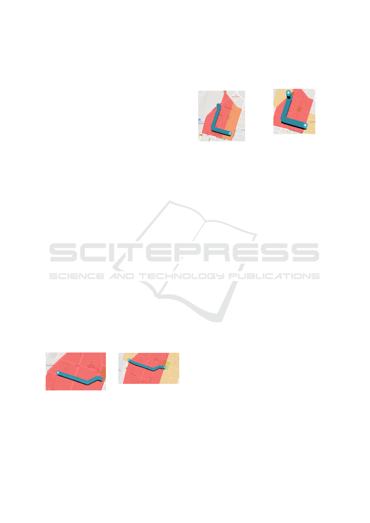
6.1 Extrapolation Scenario One
Figure 8 shows the trip expanded with the EXCL-
Algorithm. In comparison to Figure 7, the entire trip
will be preserved. Normally, all data points lying in
the red area will be deleted. So for further analysis
only the red area is available.
Figure 7: Initial situation:
scenario one.
Figure 8: Result of sce-
nario one using EXCL-
Algorithm.
Due to the use of the EXCL-Algorithm the trip
still can be used because the EXCL-Algorithm defines
a new start and target area (yellow areas in Figure 8)
of the trip. For an outsider, it is impossible to distin-
guish between the artificially generated GPS data and
the original tracked GPS data from the users.
6.2 Extrapolation Scenario Two
Figure 9: Initial situation:
scenario two
Figure 10: Result of sce-
nario two using EXCL-
Algorithm
As well as scenario one, scenario two can also be
optimized through our EXCL-Algorithm. Figure
10 demonstrates the result of the EXCL-Algorithm.
Compared to the initial consideration (see Figure 9),
two completely new areas (yellow territories see fig-
ure 10) are entered, which are the new starting area
(the top left corner of Figure 10) and the target area
(the lower right corner of Figure 10). All data points
within the red area and orange area (Figure 9) are pre-
served. Normally the whole data points in Figure 9
cannot be used for the mobility analysis. Due to the
use of our EXCL-Algorithm the complete number of
data points can now be used for further work.
7 CONCLUSION
In this paper, we presented an expanded cloaking al-
gorithm, called EXCL-Algorithm, based on super-
vised learning to expand real GPS data points of a trip
by adding new artificial start and target points within
new defined cloaking areas. The EXCL-Algorithm
enables to ensure the privacy of each user as well as
preserves the main trip data in reference to two spe-
cific scenarios where the original start points and tar-
get points are close together. The essential advantage
of this method is to protect trip data against deletion
in compliance with data protection legislation.
The core of the EXCL-Algorithm consists of four
steps. They comprise, for example, the examination
of different machine learning algorithms in order to
generate suitable artificial GPS data points. The ver-
ification of the artificially generated GPS points is
done by focusing on the distance between the GPS
data points as well as by ensuring that new areas are
entered to prevent that scenario one (only one area
without any GPS data) or scenario two (two areas di-
rectly lie to each other but no GPS data) occur again.
These verification steps, finally, enable to evaluate our
EXCL-Algorithm based on two specific scenarios.
IoTBDS 2021 - 6th International Conference on Internet of Things, Big Data and Security
162

The content of this research refers to a generic
view to all modes of transports. However, this means
that the generation of new GPS data is not only based
on the existing car or bicycle routes. The generated
data can for example vary from roads or enter green
areas as well. So, for an outsider, it is still impossible
to distinguish between artificially generated data or
real data because all modes of transportation can be
combined for tracking the routes in the application.
Finally, the EXCL-Algorithm preserves data that
can be used for further studies and protects the pri-
vacy of each user who contributes by tracking the
daily trips. Further studies can focus to generate only
those GPS data points lying on roads for cars or pave-
ments for pedestrians depending on the provided data.
This studies would precise the EXCL-Algorithm and
its data generation and would focus on only one mode
of transportation.
ACKNOWLEDGEMENTS
This paper is based on the research and develop-
ment joint project NUMIC - New Urban Awareness
of Mobility in Chemnitz. It is founded by the Fed-
eral Ministry of Education and Research (BMBF) and
the European Social Fund under the grant number
01UR1804A. The responsibility for this publication
lies with the authors.
REFERENCES
Bundesministerium f
¨
ur Verkehr und digitale Infrastruk-
tur (2020). Mobilit
¨
at in Deutschland (MiD). ttps:
//www.bmvi.de/SaredDocs/DE/Artikel/G/ mobilitaet-
in-deutschland.html. [Online, accessed 2-November-
2020].
Chemnitz, Stadt der Moderne (2020). Mobilit
¨
atsverhalten
- Untersuchung “Mobilit
¨
at in St
¨
adten”. URL:
https://www.chemnitz.de/chemnitz/de/unsere-stadt/
verkehr/verkehrsplanung/mobilittsverhalten/index.
html. [Online, accessed 30-October-2020].
Chow, C.-Y. and Mokbel, M. F. (2011). Privacy of spatial
trajectories. In Computing with spatial trajectories,
pages 109–141. Springer.
Claudio, B., Sean Wang, X., and Jajodia, S. (2005). Pro-
tecting privacy against location-based personal iden-
tification. Jonker, Petkovi
´
c (Hg.) 2005 – Secure Data
Management, page 185–199.
Feng, T. and Timmermans, H. J. (2017). Using recurrent
spatio-temporal profiles in gps panel data for enhanc-
ing imputation of activity type. Big Data for Regional
Science, pages 121–130.
Ghinita, G., Kalnis, P., and Skiadopoulos, S. (2007). Pro-
ceedings of the 16th international conference on world
wide web. page 371.
G
´
eron, A. (2018). Machine Learning mit Scikit-Learn und
Tensorflow. O’Reilly, Heidelberg.
Hoh, B., Gruteser, M., Xiong, H., and Alrabady, A. (2007).
Preserving privacy in gps traces via uncertainty-aware
path cloaking. page 161.
Hua, Y., Zhao, Z., Li, R., Chen, X., Liu, Z., and Zhang,
H. (2019). Deep learning with long short-term mem-
ory for time series prediction. IEEE Communications
Magazine, 57(6):114–119.
Jeansoulin, R., Papini, O., Prade, H., and Schockaert, S.
(2010). Methods for handling imperfect spatial infor-
mation, volume 256. Springer.
Martens, K. (2007). Promoting bike-and-ride: The dutch
experience. Transportation Research Part A: Policy
and Practice, 41(4):326–338.
Merkel, D. A. (2018). Rede von bundeskanzlerin dr. angela
merkel beim ix. petersberger klimadialog am 19. juni
2018 in berlin. Bulletin, die Bundesregierung, 68.
Niu, B., Li, Q., Zhu, X., Cao, G., and Li, H. (2014). Achiev-
ing k-anonymity in privacy-aware location-based ser-
vices. IEEE INFOCOM 2014 2014, page 754–762.
Ortmeyer, T. H. and Pillay, P. (2001). Trends in transporta-
tion sector technology energy use and greenhouse gas
emissions. pages 1837–1847.
Pan, X., den Elzen, M., H
¨
ohne, N., Teng, F., and Wang,
L. (2017). Exploring fair and ambitious mitigation
contributions under the paris agreement. pages 49–56.
Ritchie, H. (2020). Cars, planes, trains: where
do CO2 emissions from transport come
from? URL: ttps://ourworldindata.org/
co2-emissions-from-transport.\newblock[Online,
accessed28-October-2020].\bibitem[Sceider et al.,
2020]ExtendTrack Scheider, S., Wang, J., Mol, M.,
Schmitz, O., and Karssenberg, D. (2020). Obfus-
cating spatial point tracks with simulated crowding.
International Journal of Geographical Information
Science, 34(7):1398–1427.
Seber, G. and Lee, A. (2012). Linear Regression Analysis.
Wiley Series in Probability and Statistics. Wiley.
Sumo (2020). Simulation of urban mobility. URL: eclipse.
org/sumo/. [Online, accessed 07-September-2020].
Sweeney, L. (2012). k-anonymity: A model for protecting
privacy: International journal of uncertainty, fuzziness
and knowledge-based systems, 10(05), 557-570.
Trujillo-Rasua, R. and Domingo-Ferrer, J. (2015). Privacy
in spatio-temporal databases: A microaggregation-
based approach. 567:197–214.
Wang, S. and Wang, X. S. (2010). In-device spatial cloaking
for mobile user privacy assisted by the cloud. pages
381–386.
Wardman, M., T. M. . P. M. (2007). Factors influencing the
propensity to cycle to work. Transportation Research
Part A: Policy and Practice, 41(4):339 – 350.
Zhu, X., Chi, H., Niu, B., Zhang, W., Li, Z., and Li, H.
(2013). Mobicache: When k-anonymity meets cache.
pages 820–825. IEEE.
Use of Machine Learning for Expanding Realistic and Usable Routes for Data Analysis on Sustainable Mobility
163
