
Selfie Drones for 3D Modelling, Geological Mapping and Data
Collection: Key Examples from Santorini Volcanic Complex, Greece
Fabio Luca Bonali
1,2 a
, Varvara Antoniou
3b
, Othonas Vlasopoulos
3c
, Alessandro Tibaldi
1,2 d
and Paraskevi Nomikou
3e
1
Department of Earth and Environmental Sciences, University of Milano-Bicocca,
Piazza della Scienza 4 – Ed. U04, 20126, Milan, Italy
2
CRUST- Interuniversity Center for 3D Seismotectonics with Territorial Applications, Italy
3
Department of Geology and Geoenvironment, National and Kapodistrian University of Athens,
Panepistimioupoli Zografou, 15784 Athens, Greece
Keywords: Geological Mapping, Structure from Motion, Santorini Volcano, Virtual Outcrop, LBA Eruption.
Abstract: In the present work, we tested the use of selfie drones as a tool for 3D modeling, geological mapping, and
data collection. The model we used is a 0.300-kg multirotor quadcopter being equipped with a 1/2.3-inch
CMOS sensor capable of capturing 12 Megapixel pictures, attached to a 2-axis mechanical gimble and with
approximately 16 minutes of flight time. Test sites are located in Santorini and are characterised by different
settings: i) the 1570-1573 AD volcanic crater area, in Nea Kameni island, has a mostly horizontal topography;
ii) the outcrop along Vlychada beach, showing layers of the Late Bronze Age (also well-known as Minoan)
eruption, has mostly vertical topography. By applying the Structure from Motion techniques to pictures
collected using the selfie drone, we were capable of: i) reconstructing the two sites with centimetric to sub-
centimetric resolution; ii) recognizing geological features on very high-resolution Digital Surface Models and
Ortomosaics; iii) mapping vertical cliffs made up of volcanic deposits on 3D Digital Outcrops Models; iv)
collect new quantitative data for both sites.
1 INTRODUCTION
Field studies and data collection are vital for mapping
and understanding the active geological processes on
Earth, particularly for those that induced superficial
deformations like earthquakes and shallow magmatic
processes (e.g. Bonali et al., 2012; Tibaldi et al.,
2017). However, field studies and direct observations
are very often limited by specific field-related
conditions such as the inaccessibility of key outcrops
due to their location in remote or dangerous areas
(e.g. Tibaldi et al., 2008). The Structure from Motion
and Multiview stereo (SfM-MVS) photogrammetry
techniques, where photos are collected using
Unmanned Aerial Vehicles (UAVs), are nowadays
widely used in Earth and Environmental Sciences to
a
https://orcid.org/0000-0003-3256-0793
b
https://orcid.org/0000-0002-5099-0351
c
https://orcid.org/0000-0002-6713-9141
d
https://orcid.org/0000-0003-2871-8009
e
https://orcid.org/0000-0001-8842-9730
overcome these problems providing high-resolution
3D Digital Outcrop Models (DOMs), digital surface
models (DSMs) and Orthomosaics as results (e.g.
Bonali et al., 2019a; Fallati et al., 2019). Most people
dealing with geological and geohazard studies use
different types of UAVs: balloons, multi-rotor, fixed-
wing and hybrid. Whereas balloons do not need fuel
or battery, on the other hand they cannot be remotely
controlled. Hybrid types allow to switch between
flying like a fixed-wing aircraft and hovering like a
multi-rotor one. The fixed-wing type can cover larger
areas in a smaller time frame using high quality
cameras, but such model is more difficult to be
transported and more expensive than multi-rotor
UAVs. Based on our experience, the latter can fly at
very low heights attaining a great field resolution, and
Bonali, F., Antoniou, V., Vlasopoulos, O., Tibaldi, A. and Nomikou, P.
Selfie Drones for 3D Modelling, Geological Mapping and Data Collection: Key Examples from Santorini Volcanic Complex, Greece.
DOI: 10.5220/0009575001190128
In Proceedings of the 6th International Conference on Geographical Information Systems Theory, Applications and Management (GISTAM 2020), pages 119-128
ISBN: 978-989-758-425-1
Copyright
c
2020 by SCITEPRESS – Science and Technology Publications, Lda. All rights reserved
119
much more importantly, take-off and landing
operations are easier than for fixed-wing models; this
is crucial especially in difficult logistic terrains (e.g.
outcropping lavas, Bonali et al., 2019a).
In the present work we tested the use of the so
called “selfie drones” - quadcopter type - to produce
very high-detailed 3D DOMs of relevant outcrops for
geological mapping, data collection and scientific
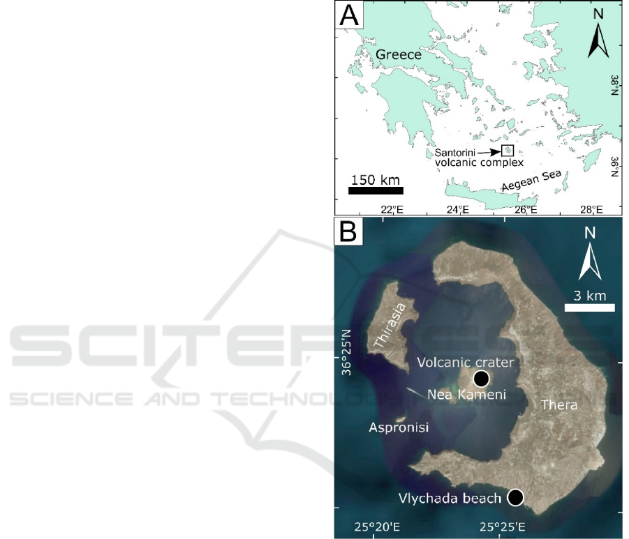
dissemination. As case studies we selected two sites
within the Santorini volcanic complex (Fig. 1) with
different characteristics: i) the 1570-1573 AD
volcanic crater in Nea Kameni island and ii) an
outstanding vertical outcrop showing volcanic
layered deposits, along the Vlychada Beach, southern
Santorini (Fig. 1B).
2 GEOLOGICAL SETTING OF
KEY SITES
Santorini volcanic group is a ring of three islands
(Thera, Therasia, and Aspronisi) around a flooded
caldera containing the islands of Palea and Nea
Kameni, which postdate caldera collapse (3.6ka) and
are the subaerial expressions of an intracaldera,
largely submarine lava shield (Druitt, 2014). The
caldera is a 11x7km composite structure resulting
from at least four collapses over the last 200ky (Druitt
and Francaviglia, 1992), the last of which took place
during, and immediately following, the ~1630 BCE
‘Minoan’ eruption (Friedrich et al., 2006). It consists
of three flat-floored basins: a large northern 390m
deep, and two smaller ones (western: 320m and
southern: 270m respectively, Nomikou et al., 2013).
The Kameni islands are the subaerial expression
of a 4.3 ± 0.7km
3
intracaldera shield, 3.5km in basal
diameter, the summit of which towers 470m above
the caldera seafloor. The magmatic vents of both, lie
within a NE-SW volcanotectonic line which controls
the magma ascent of the region.
The evolution of the Kameni islands has been
determined by 9 subaerial eruptions: 197 BCE,
AD46-47, AD726, 1570-1573, 1707-1711, 1866-70,
1925-28, 1939-41, and 1950 (Pyle and Elliot, 2006)
that discharged dacitic flows and formed domes,
channels and levees, blocky lavas, ash plumes
(Vulcanian eruptions) and ballistic ejecta.
Bathymetric imagery data have revealed unknown
submarine flows (pillow lavas) defining the actual
morphology (pillow lavas) and final volume of
products from Kameni Volcano to 4.85±0.7 km
3
(Nomikou et al., 2014).
The 1570-1573 AD volcanic crater is located in
the northeastern part of it. During its
surtseyan activity
which was accompanied by ash-fall and block fall-out,
a small lava dome named Mikri Kameni was extruded
(Watts et al., 2015).
Figure 1: Location of Santorini group in the Aegean Sea (A)
and selected sites belonging to Santorini Volcanic Complex
(B).
Moving to the external southern part of Thera
island, and along Vlychada beach, a very well
exposed section with pumice layers deposited during
the famous Late Bronze Age (LBA) (well-known also
as Minoan) eruption, can be seen. The LBA eruption
of Santorini has influenced the decline of the great
Minoan civilization on Crete, making it an iconic
event in both volcanology and archaeology (e.g.,
Manning et al. 2006; Druitt, 2014). It discharged
between 30 and 80km
3
(dense rock equivalent;
Johnston et. al., 2014) of rhyodacitic magma, mostly
GISTAM 2020 - 6th International Conference on Geographical Information Systems Theory, Applications and Management
120
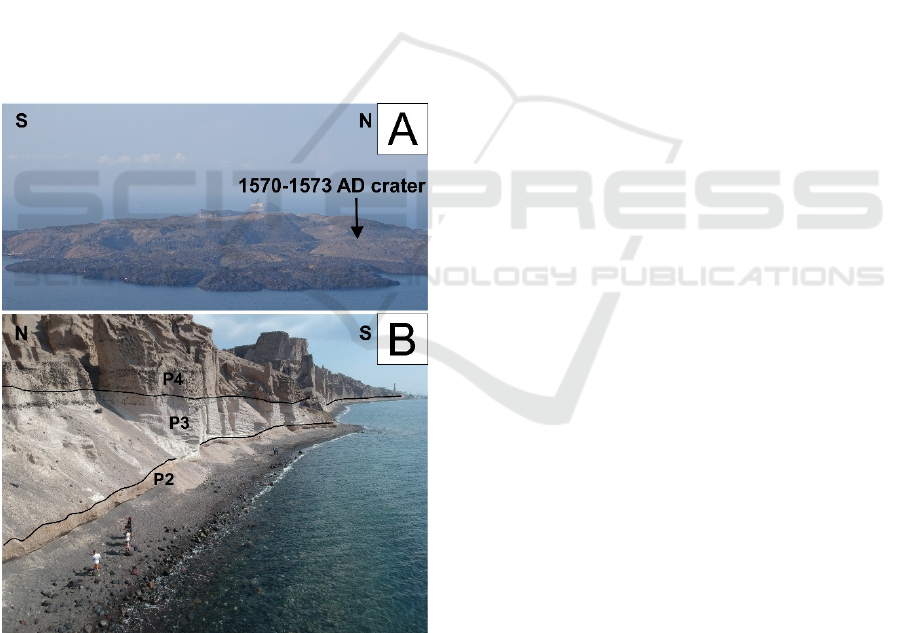
as pyroclastic flows which entered the sea, and are
preserved as ignimbrite in the surrounding submarine
basins (Sigurdsson et. al., 2006). According to
numerous volcanological studies, there is a consensus
that the eruption occurred in four major phases with
an initial precursory phase (Reck, 1936; Heiken and
McCoy, 1990; Druitt, 2014). In Vlychada, volcanic
products from phases P2 and mostly P3 and P4 can be
recognized. Phase P2 products are dominated by
pyroclastic surge deposits with multiple bedsets,
dune-like bedforms with wavelengths of several
meters or more, bomb sag horizons, and TRM
temperatures of 100–250°C. Phase P3 is a coarse-
grained, massive, phreatomagmatic ignimbrite up to
55m thick (Druitt et al., 1999), still reflecting magma-
water interaction and deposited at low temperatures
(Druitt, 2014; McClelland E. & Thomas R. A.,1990).
Phase P4 is a tan- to pink- colored compound
ignimbrite (“tan ignimbrite”) (Druitt, 2014), mostly
finegrained (ash and lapilli grade), with a high
abundance of comminuted lithic debris in the ash
fraction (Bond and Sparks, 1976) (Fig. 2B).
Figure 2: (A) Panoramic view of Nea Kameni island, the
location of 1570-1573 crater is indicated. (B) UAV-
captured picture showing part of the LBA deposit
outcropping along the Vlychada beach, the recognizable
phases (P2, P3 and P4) are indicated.
3 3D MODELLING
In this section we present the used workflow, aimed
at 3D DOMs construction, which can be divided in
three parts: i) appropriate UAV selection, ii) data
collection (digital image gathering and setup of
Ground Control Points - GCPs), and iii) SfM-MVS
photogrammetry processing - data processing and
model reconstruction. The results are in the form of
Digital Surface Models (DSMs), Orthomosaics and
3D DOMs (or Virtual Outcrops).
3.1 UAV Selection and Use
For the present research, a commercial multi-rotor
vehicle has been chosen, since it can be remotely
controlled, is characterized by a stable hovering, can
be easily transported in the field and is less expensive
than hybrid and fixed-wing models. In addition, it can
fly at very low heights, thus obtaining greater field
resolution, while take-off and landing operations are
smoother compare to that of fixed-wing models and
this can be crucial especially when operating in
difficult logistic terrains, such as lava flow outcrops
or remote beach areas (Bonali et al., 2019a; Fallati et
al., 2019). Having that in mind, we selected the DJI
Spark “selfie drone” (Fig. 3), being a 0.300-kg
vehicle equipped with a 1/2.3 inch CMOS sensor
capable of capturing 12 Megapixel pictures, including
EXIF information (Exchangeable Image file Format)
GPS geographic coordinates (DATUM WGS84), and
video up to 1080p at 30 fps, while its storage capacity
is up to 64 GBs via a Micro SD card. Its flight time is
approximately 16 minutes, thus four batteries and an
external charger (since it can be also charged by USB
plug) were used for the survey. The camera is
attached to a 2-axis mechanical gimble that provides
stabilization, allowing to capture clear, stable images
and video, having a tilting range of 0-85°. Owing to
its small size and low weight, we retain that this
model is useful for field research and 3D DOM
reconstruction, particularly for outcrops located in
very remote areas where the equipment must be
carried on foot.
3.2 Flight Mission and Data Collection
The first step has been devoted to defining the area to
be surveyed and to planning the details of the flight
missions, such as path orientation. In doing this, care
must be taken of wind direction, which may affect
UAV flight performance. As the surveyed geological
objects are situated in very remote areas, we made use
of the smaller DJI Spark, managed through the DJI
Selfie Drones for 3D Modelling, Geological Mapping and Data Collection: Key Examples from Santorini Volcanic Complex, Greece
121

GO App (https://www.dji.com/it/goapp). Generally,
mission planning involves fundamental parameters
like path orientation, overlaps of images, flight
height, flight speed, also depending on camera
characteristics (e.g. Bonali et al., 2019). Such
parameters influence the quality of the generated
products (3D point cloud, DSM, orthomosaic, 3D
Model). As suggested in recent works (Gerloni et al.,
2018; Antoniou et al. 2019; Bonali et al. 2019a;
Krokos et al. 2019), UAV-captured photos should
have an overlap of 90% along single paths and 80%
in a lateral direction, so as to obtain a better alignment
of the images and reduce distortions on the resulting
orthomosaics. The UAV we tested does not use any
autopilot system, so that it has been manually
controlled by the pilot for the entire duration of the
mission. We are aware that not using mission
planning software can affect the final quality of the
model, but it was one of the challenge of the present
work).
Figure 3: The selfie drone used in the present work, also
equipped with propeller guards, person for scale.
In order to reach the goals of the present work,
during image collection pictures were taken from a
height lower than 30 m, the drone flew at a speed of
2 m/s with an overlap consistently in a range of 90-
85% along paths and 80-75% in a lateral direction;
images were captured every 2 seconds (equal time
interval mode), and in optimal light conditions,
suitable for the camera ISO range (100-1600). This
was done to minimize the motion blur, to avoid the
rolling shutter effect, and to achieve well-balanced
camera settings (exposure time, ISO, aperture), thus
ensuring sharp and correctly exposed images (e.g.
Vollgger et al. 2016). Moreover, to reduce shadows
around elevated features, drone was operated when
the sun was straight overhead (at zenith). In order to
allow the co-registration of datasets and the
calibration of models resulting from SfM-MVS
photogrammetry processing (e.g. James and Robson,
2012; Turner et al., 2012; Westoby et al., 2012; James
et al., 2017), World Geodetic System (WGS84)
coordinates of, at least, four artificial Ground Control
Points (GCPs) were fixed near every corner of each
surveyed area (an additional one was selected in the
central part) reducing the ‘doming’ effect resulting
from SfM processing.
3.3 Photogrammetry Processing
After photo collection, the next step is dedicated to
data processing aimed at 3D DOMs, DSMs and
Orthomosaics generation. The collected images have
been processed through Agisoft Metashape
(http://www.agisoft.com/), a commercial Structure
from Motion software (SfM). This application has
been increasingly used for both UAV and field based
SfM reconstructions, owing to its user-friendly
interface, intuitive workflow and high quality of point
clouds (Burns et al., 2017).
Figure 4: (a) UAV-based SfM-MVS Workflow used, (b)
UAV-collected pictures already aligned with the processed
sparse cloud. (c) Dense cloud generated by the SfM
software showing the 1570-1573 Volcanic Crater.
GISTAM 2020 - 6th International Conference on Geographical Information Systems Theory, Applications and Management
122

SfM-MVS techniques allowed us to identify
matching features in different photos and combine
them to create a sparse and a dense cloud, an
orthomosaic, a DSM, and eventually a 3D DOMs as
final products (Stal et al., 2012; Westoby et al., 2012).
The steps leading to model construction are shown in
Figure 4A; further details are provided hereunder.
The first step was to obtain an initial low-quality
photo alignment, only considering measured camera
locations. Thereafter, we excluded the photos with
quality value ˂0.8 (or out of focus) from any further
processing, using the tool provided by the software
that is designed to detect poorly focused images
(Agisoft L.L.C, 2020). Following this initial quality
check, Ground Control Points (GCPs) were added to
all photos, where available, so as to: i) scale and
georeference the point cloud (and thus the resulting
model); ii) optimize extrinsic parameters, such as
estimated camera locations and orientations; iii)
improve the accuracy of the final model.
Photos were
then realigned in high quality setting, camera
locations and orientations were better established, and
the sparse point cloud was computed by the software
(e.g. Fig. 4B). The next phase consisted in
reconstructing the dense point cloud (e.g. Fig. 4C)
from the sparse point cloud, using a mild depth
filtering and medium quality settings. The 3D DOMs,
DSMs and orthomosaics were finally created through
the Agisoft Metashape software. The resulting 3D
DOMs are characterized by a high-resolution texture
with a pixel size < 1.0 cm/pixel.
3.4 Georeferencing of GCPS
In order to allow the co-registration of datasets and
calibration of models as well as for reducing the
‘doming’ effect resulting from SfM processing (e.g.
Orthomosaics and DSMs), World Geodetic System
(WGS84) coordinates of, at least, four artificial
Ground Control Points (GCPs) were established near
each corner and another one in the central part of each
surveyed area (e.g. James and Robson, 2012; Turner
et al., 2012; Westoby et al., 2012; James et al., 2017).
For surveying GCPs, we placed well visible artificial
markers, as well as natural targets (e.g. lava flow
borders). GCPs were surveyed with the Emlid Reach
RS©, low-cost single frequency receivers (Rover and
Base) in RTK configuration (with centimetre-level
accuracy). In regard to the surveys in Santorini, we
used the Long-Range Radio (LoRa 868/915 MHz)
connection mode where the base was set on a fix
position and sent a real-time correction to the Rover.
The LoRa mode can be advantageous in the absence
of international GNSS service or CORS network. All
the z (altitude a.s.l.) values of the GCPs were
corrected using the regional geoid model to obtain the
orthometric height for the models.
4 RESULTS
In this section we provide all details regarding the 3D
DOMs, DSMs and orthomosaic for the two studied
areas, including new 2D and 3D maps, data and
interpretations.
4.1 Volcanic Crater in Nea Kameni
A total number of 1522 of pictures have been
collected using nadir camera orientation and 1231 of
them have been correctly aligned and used for the
dense cloud generation. The remnant 291 have been
excluded because they resulted out of focus, too dark
or too white, or below the quality threshold value of
0.8 applied for this model.
The resulting model for the 1570-1573 volcanic
crater has an overall extent of 207x 291 m, a
resolution of 3.79 cm/pix for the DSM and of 9.47
mm/pix for both the orthomosaic and the texture of
the 3D DOM. The DSM values are in the range of
11.02- 49.15 m above the sea level (a.s.l.) (Fig. 4). By
analysing the Orthomosaic, DSM and the 3D DOM
we also recognised the following features: i) the
crater is slightly elongated along N5°E direction
(102.52 x 95.33 m); ii) by 3D analysis it is possible to
trace the line connecting the two crater rim depressed
points (e.g. Tibaldi, 1995; Bonali et al., 2011) in the
same direction; iii) in the northernmost part of the
crater an open fracture with a dilation of 4.7-5.3 m is
present and iv) the crater has a depth of 31.43 m.
4.2 Volcanic Deposit along the
Vlychada Beach
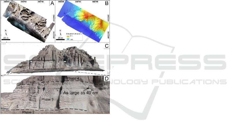
A total number of 568 pictures have been collected
and considering the geometry of the outcrops, that is
almost vertical, the majority of them have been
collected with an oblique camera orientation.
439 of them have been correctly aligned and used
for the dense cloud generation, whereas 129 have
been excluded, using the same method as in the
previous mentioned model. In addition, a mask has
been applied to all photos, in order to exclude the sky
and the sea water from the processing, to avoid
artefacts and noises. The model for the volcanic
deposit surveyed along the Vlychada beach has an
overall extent of 157 x 128 m, a resolution of 1.67
Selfie Drones for 3D Modelling, Geological Mapping and Data Collection: Key Examples from Santorini Volcanic Complex, Greece
123
cm/pix for the DSM and of 8.37 cm/pix for both the
orthomosaic and the texture of the 3D DOM.
The DSM values are in the range -1.61- 38.3m
a.s.l.. Regarding the volcanic phases that can be
recognised, it resulted very useful to collect the
thickness of them directly on the 3D DOM, because
of the vertical geometry of the outcrop. These
measurements have been collected in Agisoft
Metashape, using the ruler tool: the phase 2 has a
thickness of 2m, phase 3 ranges between 7 and 10 m
and phase 4 has an outcropping thickness of 25m. In
addition, it is possible to appreciate the presence of
several blocks as well as to quantify their dimension
as shown in Figure 5D.
5 DISCUSSION
In the present section we discuss the use of selfie
drones for 3D modelling and mapping, as well as we
present new outcomes for the studied areas.
5.1 Selfie Drones for Surveying, 3D
Modelling and Mapping
At a general level, UAVs are excellent instruments to
collect highly detailed pictures and videos from the
above of the key sites (e.g. Fig. 2A), which is
impossible using only classical field activity. These
images can be used for research activity and better
interpretation as well as for outreach activity (e.g.
Bonali et al., 2019a; Pasquaré Mariotto et al., 2020).
Furthermore, a field view from the drone during field
surveys can also help in planning further steps of
exploration. In view of the above, a selfie drone, due
to its small dimension and weight, is useful in
supporting field exploration and photo/video
collection, even though it is recommended to work in
the height and distance range suggested by local laws
and manufacture’s technical manual.
Regarding the 3D modelling, and consequent
mapping and data collection activity, both models
have great resolution, in terms of DSM and
Orthomosaic. In particular, the latter and the texture
of the 3D DOM, reach a resolution greater than 1 cm.
This excellent resolution is helpful for classical
mapping and data collection on DSM/Orthomosaic,
as well as is crucial for mapping 3D vertical outcrops,
including the quantitative characterisation of small
objects like the ones included in the volcanic layers
outcropping along the Vlychada beach. Based on the
experience gained from the present work we were
capable of flying up to 50 m from the ground to
collect some pictures for the latter model.
Figure 5: (A) Orthomosaic and DSM (B) of the 1570-1573
volcanic crater in Nea Kameni; a.s.l.: above the sea level.
(C-D) Detailed view of the northernmost fracture. (E) 3D
Virtual Outcrop of the volcanic crater available online
(https://skfb.ly/6PUNt).
Respect to other models, there are some negative
aspects that we highlighted. Selfie drones must be
manually controlled during the survey and they can
be more affected by the wind; so, an expert pilot is
recommended to collect pictures in the best way
possible. This can result in a larger number of
collected pictures compared to those really needed for
SfM-MVS processing, since some of them must be
removed due to out of focus condition or incorrect
white balance. To fly above 50 m and to cover larger
GISTAM 2020 - 6th International Conference on Geographical Information Systems Theory, Applications and Management
124
areas, other types of UAVs can be used: balloons,
larger multi-rotor, fixed-wing and hybrid. Balloons
do not need fuel or a battery, but they cannot be
remotely controlled. The fixed-wing type can cover
larger areas in a smaller time frame using high quality
cameras, but such model is more difficult to be
transported in the field. Hybrid types allow to switch
between flying like a fixed-wing aircraft and hovering
like a multi-rotor one. The latter two are more
expensive than commercial multi-rotor type. Larger
multi-rotor can fly for a longer time respect to a selfie
drone, at very low heights attaining a great field
resolution, and much more importantly, take-off and
landing operations are easier than for fixed-wing
models; this is crucial especially in difficult logistic
terrains.
Figure 6: (A) Orthomosaic and DSM (B) of the outcrop
related to LBA deposits along the Vlychada beach; a.s.l.:
above the sea level. (C) 3D Virtual Outcrop available online
(https://skfb.ly/6PZPO), where it is possible to recognise
the different phases with very high detail (D).
5.2 New Outcomes for the Studied
Areas
Regarding the 1570-1573 volcanic crater in Nea
Kameni, we defined its dimension and depth with
very high accuracy, also discovering a N5°E
elongation trend that matches with the line connecting
the two most depressed points along the crater rim.
As suggested by Tibaldi (1995) and Bonali et al.
(2011), such line can represent, with low discrepancy,
the direction of magma feeding fractures, suggesting
that the 1570-1573 AD eruptions were driven by a
fissure. Dykes outcropping along the Northern
Caldera Wall have a NE-SW dominant strike, even
though the N-S direction is also represented in the
dataset (Browning et al., 2015), suggesting that
magma can reach the surface also along this direction
in central Santorini. Finally, the fracture located just
north of the crater has a dilation of about 5 m that is
consistent with dyke-induced fractures in Northern
Iceland (e.g. Bonali et al., 2019a,b).
Regarding the volcanic deposits measured along
the Vlychada beach, we defined the boundaries of
different phases of the LBA deposits on the 3D DOM,
as well as we measured their thickness with very high
accuracy. Also, it was possible to observe the cliff
closely enough to distinguish individual and small
components such as volcanic blocks within the bulk
of each phase and to quantify their dimensions.
5.3 3D DOMs and Virtual Outcrops for
Teaching and Dissemination
The two presented sites can be used also for teaching
and outreach activity, as well as they can be both
suggested as geosites. In fact, they have a
considerable scientific value and a potentially high
educational value, enhanced by their accessibility and
safety (e.g. Pasquaré Mariotto et al., 2020).
Recent improvements in Geographic Information
Systems (GIS) technologies can provide new
opportunities for immersive and wide engaging
public audiences. Story Maps being interactive
webGIS applications can provide support for
scientific storytelling in a compelling and
straightforward way (Antoniou, et al., 2019) using
multi-media assets (e.g. photos, videos, 3D DOMs)
and narrative texts with the aim of visualizing spatial
data effectively.
As previously tested (Antoniou et al., 2018; 2019,
2019a, 2019b) these applications can represent an
interactive way for presenting the geological and
geomorphological characteristics of places which can
be defined as geotopes or protected areas worldwide,
providing a quick access of all useful data to a wide
audience and thus developing the interest and
possibly motivating people to learn more and visit the
area.
With the purpose of enhancing the popularization
and fruition of these two sites, we published them as
“Virtual Outcrops” (Xu et al. 1999; Trinks et al. 2005;
Tavani et al. 2014) on the web. The 1570-1573 AD
volcanic crater is available as Virtual Outcrop at
https://skfb.ly/6PUNt and the volcanic deposits
section in Vlychada beach, at https://skfb.ly/6PZPO.
Both of them can be visualized using a laptop or
Selfie Drones for 3D Modelling, Geological Mapping and Data Collection: Key Examples from Santorini Volcanic Complex, Greece
125
mobile phone (in 2D) or using a Mobile VR headset
to appreciate the third dimension (e.g. Fig. 6A).
Finally, as suggested by Gerloni et al. (2018) and
Krokos et al. (2019), SfM-MVS-derived 3D DOMs
can be imported in a game engine to build fully
navigable immersive Virtual Reality systems. Such
approach has been firstly used for teaching activity
(e.g. Fig 6B) and dissemination activity to popularise
geosciences to non-academic audiences (e.g.
citizens).
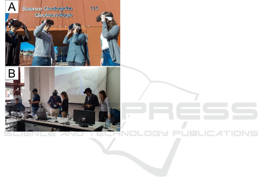
Figure 7: (A) An example of a research group observing the
same virtual outcrop using a mobile VR headset. (B) An
example of an outreach event carried out using the
Immersive Virtual Reality (Bonali et al., 2019c).
5.4 Future Developments
Regarding the future roadmap for our approach, we
expect a contribution from Neanias project
(https://www.neanias.eu/) regarding online services
devoted to SfM-MVS photogrammetry processing, in
order to enlarge the community working with this
technique, possibly involving also non-scientists and
non-academics. Up to now, we cannot find a robust
and efficient open source software for SfM-MVS
processing, that can be applied to both terrestrial and
marine environments; for the latter case, pictures are
usually collected using (Remotely Operated Vehicle)
ROVs. From another side, the Selfie drone-based
approach can motivate scientists to collect data in
remote and dangerous areas, thus multiplying the
amount of available 3D DOMs for the scientific
community as well as the storage dimension needed
for the DSMs, Orthomosaics and the dense clouds. In
view of the above, an online service for data storage
and 3D scientific visualisation is also recommended.
For example, the model related to the entire project of
the 1570-1573 AD crater is as large as 54 GBs, and it
is difficult to be shared with the scientific community,
even though the high resolution of the 3D DOM,
DSM and Orthomosaic can be crucial for better
understanding volcano dynamics, relationships with
release of volcanic gases, tectonic settings, magmatic
intrusions.
6 FINAL REMARKS
In the present work we tested the use of selfie drones
as a tool for 3D modelling, geological mapping and
data collection. Test sites are located in Santorini and
are characterised by different settings: i) the Crater
area in Nea Kameni has a mostly horizontal
topography; ii) the Vlychada beach has a dominant
vertical topography. By applying the Structure from
Motion techniques to pictures collected using the
selfie drone, we were capable of: i) reconstructing the
two sites with centimetric to sub-centimetric
resolution; ii) recognizing geological features on very
high resolution DSMs and Ortomosaics; iii) mapping
vertical volcanic deposits on 3D DOMs; and iv)
collecting new quantitative data for both sites.
ACKNOWLEDGEMENTS
This work is supported by: i) MIUR Argo3D project
ACPR15T4_00098 and ii) 3DTeLC Erasmus+
Project 2017-1-UK01-KA203-036719. This article is
also an outcome of Project MIUR – Dipartimenti di
Eccellenza 2018–2022 and of GeoVires, the Virtual
Reality Lab for Earth Sciences host at Department of
Earth and Environmental Sciences, University of
Milan Bicocca, U4, Piazza della Scienza 4, 20126
Milan, Italy. Agisoft Metashape is acknowledged for
photogrammetric data processing. Finally,
NEANIAS project is acknowledged for financial
support for the submission of this paper.
REFERENCES
Agisoft, L. L. C. "Agisoft metashape user manual,
Professional edition, Version 1.6." Agisoft LLC, St.
Petersburg, Russia, from https://www.agisoft.com/
pdf/metashape-pro_1_6_en.pdf, accessed March 12
(2020):2020.
GISTAM 2020 - 6th International Conference on Geographical Information Systems Theory, Applications and Management
126

Antoniou, V., Nomikou, P., Bardouli, P., Lampridou, D.,
Ioannou, Th., Kalisperakis, I., Stentoumis, Ch.,
Whitworth, M., Krokos, M. & Ragia, L. (2018). An
Interactive Story Map for the Methana Volcanic
Peninsula. In Proceedings of the 4th International
Conference on Geographical Information Systems
Theory, Applications and Management (GISTAM
2018), pages 68-78, ISBN: 978-989-758-294-3.
Antoniou, V.; Ragia, L.; Nomikou, P.; Bardouli, P.;
Lampridou, D.; Ioannou, T.; Kalisperakis, I.;
Stentoumis, C., 2018. Creating a Story Map Using
Geographic Information Systems to Explore
Geomorphology and History of Methana Peninsula.
ISPRS Int. J. Geo-Inf. 2018, 7, 484.
Antoniou, V., Nomikou, P., Bardouli, P., Sorotou, P.,
Bonali, F.L., Ragia, L. and Metaxas, A., 2019. The
Story Map for Metaxa Mine (Santorini, Greece): A
Unique Site Where History and Volcanology Meet
Each Other. In Proceedings of the 5th International
Conference on Geographical Information Systems
Theory, Applications and Management - Volume 1:
GISTAM, 212-219.
Antoniou, V., Nomikou, P., Zafeirakopoulou, E., Bardouli,
P., Ioannou, T., 2019a. Geo-biodiversity and cultural
environment of Nisyros volcano. 15th International
Congress of the Geological Society of Greece, Sp. Pub.
7 Ext. Abs. GSG2019-195, Athens, 22-24 May, 2019,
p. 716-717.
Antoniou, V., Nomikou, P., Papaspyropoulos, K.,
Vlasopoulos, O., Zafeirakopoulou, E., Bardouli, P.,
Chrysopoulou, E., 2019b. Geo-biodiversity and
Cultural Environment of the regions surrounding the
Corinth Gulf (Greece). Regional Conference on
Geomorphology, Focal Theme: Geomorphology of
Climatically and Tectonically Sensitive Areas,
UNESCO Global Geoparks: geoheritage assessment
and management - geo-tourism development, Abstract
book, p.256, Athens 2019.
Bonali, F. L., Corazzato, C., Tibaldi, A., 2011. Identifying
rift zones on volcanoes: an example from La Réunion
island, Indian Ocean. Bulletin of volcanology, 73(3),
347-366.
Bonali, F. L., Corazzato, C., Tibaldi, A., 2012. Elastic stress
interaction between faulting and volcanism in the
Olacapato–San Antonio de Los Cobres area (Puna
plateau, Argentina). Global and planetary change, 90,
104-120.
Bonali, F. L., Tibaldi, A., Marchese, F., Fallati, L., Russo,
E., Corselli, C., Savini, A., 2019a. UAV-based
surveying in volcano-tectonics: An example from the
Iceland rift. Journal of Structural Geology, 121, 46-64.
Bonali, F. L., Tibaldi, A., Mariotto, F. P., Saviano, D.,
Meloni, A., Sajovitz, P., 2019. Geometry, oblique
kinematics and extensional strain variation along a
diverging plate boundary: The example of the northern
Theistareykir Fissure Swarm, NE Iceland.
Tectonophysics, 756, 57-72.
Bonali, F. L., Russo, E., Savini, A., Marchese, F., Fallati,
L., Paraskevi, N., ... Garzonio, R., 2019c. Learning
outcomes from the EGU 2018 Public Engagement
grant" Shaping geological 3D virtual field-surveys for
overcoming motor disabilities". In Geophysical
Research Abstracts, Vol. 21.
Bond, A. & Sparks, R.S.J., 1976. The Minoan eruption of
Santorini, Greece, Journal of the Geological Society,
London, 132, 1–16.
Browning, J., Drymoni, K., Gudmundsson, A., 2015.
Forecasting magma-chamber rupture at Santorini
volcano, Greece. Scientific reports, 5, 15785.
Burns, J.H.R., Delparte, D., 2017. Comparison of
commercial structure-from-motion photogrammetry
software used for underwater three-dimensional
modeling of coral reef environments. In International
Archives of the Photogrammetry, Remote Sensing and
Spatial Information Sciences - ISPRS Archives (Vol.
42, pp. 127–131).
Druitt, T. H. & Francaviglia, V., 1992. Caldera formation
on Santorini and the physiography of the islands in the
late Bronze Age, Bull. Volcanol., 54, 484–493.
Druitt, T. H., 2014. New insights into the initiation and
venting of the Bronze-Age eruption of Santorini
(Greece), from component analysis, Bull. Volcanol., 76,
794.
Fallati, L., Polidori, A., Salvatore, C., Saponari, L., Savini,
A., Galli, P., 2019. Anthropogenic Marine Debris
assessment with Unmanned Aerial Vehicle imagery
and deep learning: A case study along the beaches of
the Republic of Maldives. Science of The Total
Environment, 693, 133581.
Friedrich, W., Kromer, B., Friedrich, M., Heinemeier, J.,
Pfeiffer, T., Talamo, S., 2006. Santorini eruption
radiocarbon dated to 1627–1600 Bc., Science, 312, 548.
Gerloni, I.G., Carchiolo, V., Vitello, F.R., Sciacca, E.,
Becciani, U., Costa, A., Riggi S., Bonali F.L., Russo E.,
Fallati L., Marchese F., Tibaldi A., 2018. Immersive
Virtual Reality for Earth Sciences. In 2018 Federated
Conference on Computer Science and Information
Systems (FedCSIS) (pp. 527-534). IEEE.
James, M.R., Robson, S., 2012. Straightforward
reconstruction of 3D surfaces and topography with a
camera: accuracy and geoscience application. Journal
of Geophysical Research, 117, F03017.
James, M.R., Robson, S., d'Oleire-Oltmanns, S.,
Niethammer, U., 2017. Optimising UAV topographic
surveys processed with structure-from-motion: ground
control quality, quantity and bundle adjustment.
Geomorphology, 280, 51-66.
Johnston, E. N., Sparks, R.S.J., Phillips, J.C. & Carey, S.,
2014. Revised estimates for the volume of the Late
Bronze Age Minoan eruption, Santorini. Greece, J.
Geol. Soc. Lond., 171, 583–590.
Krokos M., Bonali F., Vitello F., Antoniou V., Becciani U.,
Russo E., Marchese F., Fallati L., Nomikou P., Kearl
M., Sciacca, E., Whitworth M., 2019. Workflows for
virtual reality visualisation and navigation scenarios in
earth sciences. In 5th International Conference on
Geographical Information Systems Theory,
Applications and Management: GISTAM 2019.
SciTePress.
Selfie Drones for 3D Modelling, Geological Mapping and Data Collection: Key Examples from Santorini Volcanic Complex, Greece
127

Manning, S.W., Ramsey, C.B., Kutschera, W., Higham, T.,
Kromer, B., Steier, P., Wild, E.M.,2006. Chronology
for the Aegean Late Bronze Age 1700–1400 B.C.,
Science, 312, 565–569.
Nomikou P., Papanikolaou D., Alexandri M., Sakellariou
D., Rousakis G., 2013. Submarine volcanoes along the
Aegean volcanic arc. Tectonophysics, 597-598, pp.123.
Nomikou, P., Parks M.Μ., Papanikolaou D., Pyle D.Μ.,
Mather T.Α., Carey S., Watts A.Β., Paulatto M.,
Kalnins M., Livanos I., Bejelou K., Simou E., Perros I.,
2014. The emergence and growth of a submarine
volcano: The Kameni islands, Santorini (Greece).
GeoResJ, 1-2, pp.8.
Pasquaré Mariotto, F., Bonali, F.L., Venturini, C., 2020.
Iceland, an open-air museum for geoheritage and Earth
Science communication purposes. Special Issue
"Geoheritage and Geotourism Resources", accepted for
publication.
Pyle, D.M., Elliott, J.R., 2006. Quantitative morphology,
recent evolution, and future activity of the Kameni
Islands volcano, Santorini, Greece. Geosphere, 2(5),
253-268.
Reck, H., 1936. Santorini: Der Werdegang eines
Inselvulkans und sein Ausbruch, 1925–1928, Reinser,
Berlin.
Sigurdsson, H., Carey, S., Alexandri, M., Vougioukalakis,
G., Croff, K., Roman, C., Sakellariou, D., Anagnostou,
C., Rousakis, G., Ioakim, C., Gogou, A., Ballas, D.,
Misaridis, T., Nomikou, P., (2006). Marine
Investigations of Greece’s Santorini Volcanic Field.
Eos 87 (34), pp.337.
Stal, C., Bourgeois, J., De Maeyer, P., De Mulder, G., De
Wulf, A., Goossens, R., Hendrickx, M., Nuttens, T.,
Stichelbaut, B., 2012. Test case on the quality analysis
of structure from motion in airborne applications. In
32nd EARSeL Symposium: Advances in geosciences.
European Association of Remote Sensing Laboratories
(EARSeL).
Tavani, S., Granado, P., Corradetti, A., Girundo, M.,
Iannace, A., Arbués, P., Muñozb J.A., Mazzoli, S.,
2014. Building a virtual outcrop, extracting geological
information from it, and sharing the results in Google
Earth via OpenPlot and Photoscan: An example from
the Khaviz Anticline (Iran). Computers & Geosciences,
63, 44-53.
Tibaldi, A., 1995. Morphology of pyroclastic cones and
tectonics. Journal of Geophysical Research: Solid
Earth, 100 (B12), 24521-24535.
Tibaldi, A., Pasquarè, F. A., Papanikolaou, D., Nomikou,
P., 2008. Discovery of a huge sector collapse at the
Nisyros volcano, Greece, by on-land and offshore
geological-structural data. Journal of volcanology and
geothermal research, 177 (2), 485-499.
Tibaldi, A., Alania, V., Bonali, F. L., Enukidze, O.,
Tsereteli, N., Kvavadze, N., Varazanashvili, O., 2017.
Active inversion tectonics, simple shear folding and
back-thrusting at Rioni Basin, Georgia. Journal of
Structural Geology, 96, 35-53.
Trinks, I., Clegg, P., McCaffrey, K., Jones, R., Hobbs, R.,
Holdsworth, B., Holliman N., Imber, J., Waggott, S.,
Wilson, R., 2005. Mapping and analysing virtual
outcrops. Visual Geosciences, 10(1), 13-19.
Turner, D., Lucieer, A., Watson, C., 2012. An automated
technique for generating georectified mosaics from
ultra-high resolution unmanned aerial vehicle (UAV)
imagery, based on structure from motion (SfM) Point
clouds. Remote sensing, 4, 1392-1410.
Vollgger, S.A. and Cruden, A.R., 2016. Mapping folds and
fractures in basement and cover rocks using UAV
photogrammetry, Cape Liptrap and Cape Paterson,
Victoria, Australia. Journal of Structural Geology, 85,
168-187.
Watts, A.B., Nomikou P., Moore J.D.P., Parks M.M.,
Alexandri M., 2015. Historical bathymetric charts and
the evolution of Santorini submarine volcano, Greece.
Geochemistry, Geophysics, Geosystems, 16 (3), pp.847.
Westoby, M.J., Brasington, J., Glasser, N.F., Hambrey,
M.J., Reynolds, J.M., 2012. “Structure-from-Motion”
photogrammetry: a low-cost, effective tool for
geoscience applications. Geomorphology, 179, 300-
314.
Westoby, M.J., Brasington, J., Glasser, N.F., Hambrey,
M.J., Reynolds, J.M., 2012. “Structure-from-Motion”
photogrammetry: a low-cost, effective tool for
geoscience applications. Geomorphology, 179, 300-
314.
Xu, X., Aiken, C.L., Nielsen, K.C., 1999. Real time and the
virtual outcrop improve geological field mapping. Eos,
Transactions American Geophysical Union, 80(29),
317-324.
GISTAM 2020 - 6th International Conference on Geographical Information Systems Theory, Applications and Management
128
