
Integrated Marine Carrying Capacity (MCC) Monitoring for
Managing Marine Resource in the Age of Big Data:
Case Study - Nunukan Regency
Armi Susandi, Aristyo Wijaya, Wahyu Setyo Kuntoro, Irvan Faisal, Ayub Yoga Pratama, Indriyanti
Nurdin, and Faridl Gifari Kertabudi
Bandung Institute of Technology, Bandung, Indonesia
Keywords: Marine Ecological Carrying Capacity (MECC), Nunukan Regency, Big Data, Integration.
Abstract: In supporting the development of Indonesia's frontier islands, a method is needed to plan regional resource-
based development, especially in the marine sector. Therefore, research on integrated marine carrying capacity
(MCC) monitoring for managing marine resources in the age of big data has been conducted. In this study,
Nunukan District, North Kalimantan was chosen as the research location. In managing coastal resources in the
era of big data, a data integration process consists of regional statistical data, field observation data, and
predictive data into one portal. This integration process aims to support the one data policy and provide
convenience to policymakers to develop sustainable coastal potential based on MCC calculations. The results
of this study can then be used as benchmarks in data-driven development plans and policies.
1 INTRODUCTION
In the last six years, Indonesia has tried to return the
economic pedestal to a blue economy because
Indonesia has abundant resources in the sea.
However, the increasing intensity of climate change
on sea and coastal conditions affects efforts to manage
marine natural resources in Indonesia. Currently,
these data are still available partially or separately in
the ministries or agencies that have the authority to
provide them. Therefore, the Coordinating Ministry
for Maritime Affairs and Investment has established
an effective program for marine space management
and marine environmental protection, one of which is
creating integrated thematic and basic geospatial
information data (Silalahi, 2020). When existing data
are not integrated, it can obstruct sustainable
development and uncontrolled development
management.
At present, rapid technological developments
must be utilized to encourage the sustainable
development needed to maximise the region's
potential, including in coastal areas. The use of
technology in managing the processing of marine
resources can be an opportunity and challenge in the
future. The number of institutions and institutions that
are interested in the development of marine and
coastal areas is one of the crucial issues (Rosly, et al.,
2020). Overlapping and sectoral egos of each agency
resulted in inefficiency and underutilization of data in
supporting sustainable development.
Research on integrating data to monitor
development in marine and coastal areas is still
scarce. It is a challenge to see how integrating data
from one institution to another amid the development
of big data. To explain the reasons above, we have a
goal of how to integrate Marine Carrying Capacity
(MCC) monitoring in managing coastal resources in
the data age.
2 RESEARCH METHOD
The MECC calculation to become An MPI consists of
the carrying object component (human activities and
socioeconomic growth) and the Carrier resistance
component (ecological resilience). Human activities
include coastal and marine activities that directly
suppress ecosystems (Carriers). Socioeconomic
growth includes elements that represent coastal
populations, economies and actions to protect coastal
areas. Carrier resilience components consist of
elements that maintain or damage the structure and
function of coastal and marine ecosystems. The
78
Susandi, A., Wijaya, A., Kuntoro, W., Faisal, I., Pratama, A., Nurdin, I. and Kertabudi, F.
Integrated Marine Carrying Capacity (MCC) Monitoring for Managing Marine Resource in the Age of Big Data: Case Study - Nunukan Regency.
DOI: 10.5220/0010794600003317
In Proceedings of the 2nd International Conference on Science, Technology, and Environment (ICoSTE 2020) - Green Technology and Science to Face a New Century, pages 78-81
ISBN: 978-989-758-545-6
Copyright
c
2022 by SCITEPRESS – Science and Technology Publications, Lda. All rights reserved

elements calculated for each component can be
adjusted according to local conditions and data
availability. The MPI calculation consists of three
stages, (1) standardizing the value of each indicator
(element); (2) determining the weight of each
indicator (element); and (3) MECC index (MPI).
Table 1. MECC Indicator
3 RESULTS AND DISCUSSION
3.1 Marine Big Data
Big data has four characteristics: volume, variety,
velocity, value (Kaiser, et al., 2013). Therefore, big
marine data can be described as a collection of large
amounts of data obtained from observational data and
prediction data (Huang, et al., 2015). Based on this
description, big marine data has the following
characteristics:
a. Diverse Data Provisions
Marine big data is obtained from satellite
observations, field measurements, statistical data
from related institutions, and predictive data. Each
data has a variety of formats and types following
the characteristics of big marine data.
b. Temporality and Spatiality
Each marine big data has spatial and temporal
information stored and analyzed based on these
two components.
c. High Dimension
Apart from spatially and temporally, each marine
data still has attributes both physically,
chemically, and biology, such as temperature,
salinity, density, etc. It can be said to be a high
dimension.
d. Huge Volume
Any collected marine data will produce an
enormous volume.
e. Data Availability
Techniques are needed to maintain data reliability
in big marine data.
f. Data Security
Marine big data consists of a lot of strategic data,
so it needs to be secured.
3.2 Marine Ecological Carrying
Capacity (MECC)
Carrying Capacity can be defined as an ecological
concept which assumes that there is a limited number
of individuals who can be supported by a given
consumption value provided that the surrounding
environment does not experience degradation; this
concept directly seeks to demonstrate the relationship
between the population as a supported object and the
environment as support (carrier) to ensure
sustainability. Population carrying capacity evolves
into resource and environmental carrying capacity,
then into ecological carrying capacity (ECC)
(Martire, et al., 2015). The ECC assessment focuses
more on a more holistic framework on the conditions
of the ocean-atmosphere environment, living things
and their interactions. Such assessments provide a
comprehensive understanding of sustainable
economic and social development's environmental
impacts and reveal capacity deficits and surpluses of
specific ecosystem components. These parameters are
more accessible for the public and decision-makers to
understand (Wang, et al., 2014). The ECC is an
essential index for the sustainable development of
regional ecological environments and is used in
terrestrial environmental (Wang, et al., 2014). With
the development of the marine economy, human
activities, coastal development and pollution have
altered it.
Compo
nen
t
Elements Sub-Element Indicato
r
Carrying
Objects
(OI)
Human
Activi
ties
(HI)
Tourism
Number of
visitors
Fishing
Annual
production
of fishing
Marine
culture
Number of
aquaculture
households
Fishing
Number of
shipping vessel
Socio
Eco
nomic
develop
ment (SI)
Economy
Population
density
PDRB per
capita
Number of
electricity
customers
Protective
Actions
Human
development
index
Carriers
resilienc
e (RI)
Eco
logical
resilience
(RI)
Physical
Environ
mental
Seawater level
Current sea
Sea surface
temperature
The volume of
water in the
soil laye
r
Biological
Environ
mental
Leaf Area
Index
Ecological
Risk
Chlorophyll-a
Integrated Marine Carrying Capacity (MCC) Monitoring for Managing Marine Resource in the Age of Big Data: Case Study - Nunukan
Regency
79
Several studies have developed an index system
that evaluates the carrying capacity of the marine in
China. In their research, have developed a conceptual
model in the form of a maritime performance index
(MPI) to evaluate the Marine Ecological Carrying
Capacity (MECC) (Ma, et al., 2017) . By using the
MPI, a fast and easy to understand MECC condition
index will be obtained. Thus, the 3T area development
planning provides a new perspective for exploring the
unique use of coastal and marine resources in the 3T
area.
3.3 Marine Big Data for MECC
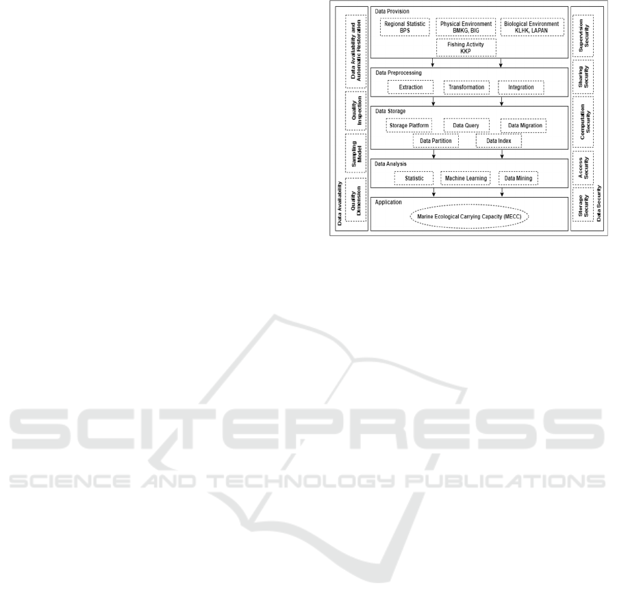
The marine significant data development architecture
for MECC monitoring can be seen in Figure 1. The
MECC marine significant data architecture comprises
data provision, data preprocessing, data storage, data
analysis and applications, quality control and data
security. In making the MECC big data, data for each
parameter used comes from regional statistical data,
observation data, and predictive data collected from
ministries and institutions such as the Central
Statistics Agency (BPS), the Meteorology,
Climatology and Geophysics Agency (BMKG), the
National Agency for Statistics. Geospatial
Information (BIG), Ministry of Environment and
Forestry (KLHK), National Space Agency (LAPAN),
and Ministry of Marine Affairs and Fisheries (KKP).
Data that is still separated will go through the data
preprocessing stage, such as extraction,
transformation and integration as the characteristics
of big data. Each data used has a type, format, and size
that results in a large volume of data, so it is necessary
to adjust data storage such as storage platforms, data
queries, data queries, data migration, data partitions,
and data indexes.
Furthermore, data analysis in MECC
calculations collaborates machine learning
techniques, statistics, and data mining based on the
MECC calculation theory described in the previous
section. Besides, quality control and data security also
play a role in this development. Through this stage,
MECC monitoring for each region can be carried out,
especially in Nunukan Regency as one of the 3T
areas. Making big marine data in MECC calculations
can support a one data policy and make it easier for
policymakers to develop sustainable coastal potential.
The results of this study can then be used as
benchmarks in data-based development plans and
policies.
Figure 1. Marine Big Data Architecture for MECC
(modified from Huang et al., 2015)
3.4 Marine Big Data Development
Challenges
Several challenges must be faced before integrating
big marine data. Based on the need for the data used,
the first challenge that can hinder is that data is still
partially scattered across various institutions and
ministries by their respective authorities. The
procedure for integrating data between institutions
requires an understanding between related institutions
to be implemented. Furthermore, if the data
integration process has been realized, big marine data
architecture development can be carried out. The
amount of data that is integrated with various types,
sizes, real-time, and high dimensions requires storage
settings, data availability, processing efficiency.
4 CONCLUSIONS
The development of MECC's marine big data
architecture consists of data provision, preprocessing,
data storage, analysis, applications, and data security
and quality control. Making big marine data in MECC
calculations can support a one-data policy and make
it easy for policymakers to develop sustainable
coastal potential and can be used as benchmarks in
data-based development plans and policies.
Integrating data with various types, sizes, real-time,
and high dimensions is a challenge in developing big
marine data for MECC monitoring
ICoSTE 2020 - the International Conference on Science, Technology, and Environment (ICoSTE)
80

ACKNOWLEDGEMENTS
Parts of this research were funded by the Ministry of
Research and Technology (Kemenristek) / National
Agency for Research and Innovation with contract
2/AMD/E1/KP.ptnbh/2020. The authors would like to
thank you for the supports of BRIN during this
research.
REFERENCES
Huang D, Zhao D, Wei L, Wang Z, and Du Y 2015 Math.
Probl. Eng.
Kaiser S, Armour F, Espinosa JA, and Money W, 2013, Big
Data : Issues and Challenge Movings Forward, The 46
th
Hawaii International Conference on System Sciences,
pp. 995-1004.
Martire S, Castellani V, and Sala S, 2015, Carrying
Capacity Assessment of Forest Resources: Enhancing
Environmental Sustainability in Energy Production at
Local State, Resources, Conservation and Recycling,
Vol. 94, pp. 11-20.
Rosly MA, Ahmad A, Tarmidi Z, Khair Z, and Zulkifli N,
2020, Towards a Collaborative Strategyfor Land and
Marine Geospatial Data Integration : A Review, IOP
Conference Series : Earth and Environmental Science,
Vol. 494, 14
th
International UMT Annual Symposium
23-25 July 2019.
Silalahi NFLP, 2020, Kebijakan Kelautan Indonesia II
untuk Pengelolaan Kawasan Konservasi Perairan
Indonesia, Kementerian Koordinator Bidang
Kemaritiman dan Investasi.
Wang S, Xu L, Yang F, and Wang H 2014, Assessment of
Water Ecological Carrying Capacity Under the Two
Policies in Tieling City on the Basis of the Integrated
System Dynamics Model, Sciences of the Total
Environment, Vol. 472, pp. 1070-1081.
Integrated Marine Carrying Capacity (MCC) Monitoring for Managing Marine Resource in the Age of Big Data: Case Study - Nunukan
Regency
81
