
Ocean Colour Climate Change: Approach Identification of Sea Level
and Physical Conditions in Setokok Sea
Muhammad Zainuddin Lubis
1
, Wenang Anurogo
1
, Budiana
2
, Widya Rika Puspita
2
, Swono
Sibagariang
3
, Jhon Hericson Purba
2
, Sapto Wiratno Satoto
4
, Hamdani Arif
3
, Rahman Hakim
4
,
Hanifah Widiastuti
4
,
Budhi Agung Prasetyo
5
, and Husnul Kausarian
6
1
Geomatics Engineering, Politeknik Negeri Batam, Batam, Indonesia
2
Electrical Engineering, Politeknik Negeri Batam, Batam, Indonesia
3
Informatics Engineering, Politeknik Negeri Batam, Batam, Indonesia
4
Mechanical Engineering, Politeknik Negeri Batam, Batam, Indonesia
5
Marine Environmental Science, Institut Teknologi Sumatera, Lampung, Indonesia
6
Department of Geology Engineering, Universitas Islam Riau, Riau, Indonesia
{zainuddinlubis, wenang, budiana, widya, swono, jhonhericson, sapto, hamdaniarif, hakim, Hanifah}
Keywords: Climate Change, Sea Level, Sea Surface Temperature, Distribution of Chlorophyll A, Bathymetry.
Abstract: Setokok Island located at the South of Batam City, Riau Islands, positioned at longitude coordinates
104.031520° and latitude 0.951068°. The data acquisition technique uses satellite altimeter imagery data,
which utilizes level 3 terra fashionable satellite imagery data. The study results show a significant change
between one season (east season) with the period of data acquisition in April and May 2020. Sea surface
temperature value is 28.7
o
C in April 2020 and 29.8
o
C in May 2020. Chlorophyll A distribution has a value
of 3.5 mg/l in April 2020 and 3.2 mg/l in May 2020. The transverse profile produced by taking into account the
sea level in Setokok Sea yielding in the mean sea level height of 1.86 meters and the average sea level of 2.67
meters. These data show a significant form of bathymetry in Setokok Sea. This research shows that global
climate change affects sea level. Furthermore, it involves primary water production and bathymetry value in
Setokok Sea.
1 INTRODUCTION
Climate change is the implication of global warming.
It has resulted in conditions that are unstable in the
lower layer atmosphere, especially the layers closest
to the earth’s surface. Global warming is caused by
increasing greenhouse gases that are dominantly
caused by industries. This global warming has
increased sea surface and has affected the Chlorophyll A
distribution in the seas, especially in islands with many
industries (Collins, et al., 2010). Climate change also
by high sea levels in an area of water, especially in
Indonesia, leading to stagnant water in tidal area,
which could cause fluctuating temperatures around
the coastal environment (Susandi, Herlianti,
Tamamadin, Nurlela, 2008). Other impacts caused by
the change of sea level is coastal erosion, a decrease
in seawater salinity, higher sea surface temperature,
decreased surface water quality, and increased risk of
flooding occurring on land in coastal environments
(Oude-Essink, Van-Baaren, de-Louw, 2010). In
general, the variety of rainfall in Indonesia is strongly
influenced by its presence on the equator, monsoon
activity, the stretch of the Pacific and Indian oceans,
and highly diverse topography. Tropical cyclone
disturbances (El-Nino, La-Nina, Madden Julian
Oscillation (MJO), and hurricane winds) could also
contribute to the types of rainfall (Horhoruw,
Atmadipoera, Nanlohy, Nurjaya, 2017)
The sea level in certain area undoubtedly is related
to the depth of seawater due to the sea's physical
conditions that are in contact with each other. This
phenomenon may have an essential role in the
sustainability of human life and other living things in
coastal areas (Antoni, et al., 2019). The alteration of
coastal regions might cause shifting in seasons and
could lead to change in the pattern/distribution of
rain, which eventually might trigger floods in the
rainy season and drought in the dry season. These
20
Lubis, M., Anurogo, W., Budiana, ., Puspita, W., Sibagariang, S., Purba, J., Satoto, S., Arif, H., Hakim, R., Widiastuti, H., Prasetyo, B. and Kausarian, H.
Ocean Colour Climate Change: Approach Identification of Sea Level and Physical Conditions in Setokok Sea.
DOI: 10.5220/0010351100200026
In Proceedings of the 3rd International Conference on Applied Engineering (ICAE 2020), pages 20-26
ISBN: 978-989-758-520-3
Copyright
c
2021 by SCITEPRESS – Science and Technology Publications, Lda. All rights reserved
issues have always been significant problems for a lot
of islands, especially for Batam Island (Lubis, et al.,
2018). The rising sea levels might sink small islands,
cause tidal floods, and lead to storm disasters/waves
at coastal areas (Dasanto, 2010).
Setokok Sea located in the South of Batam Island,
Batam City, Riau Islands, offer alternative tourism for
beach enthusiasts to spend the weekend. In Setokok
Sea environment, there is an impact indicated by
white sand around the coast. This white sand piled up,
forming a small island, at a distance of about 4 meters
from the shoreline near the Setokok Sea. The white
dune extends to more than 10 meters and is about 3
meters wide, depending on tidal wave conditions and
sea-level values. The formation of this small land is a
phenomenon of periodical rise and fall of sea-level,
combined with the gravitational force and the
attractive force of astronomical objects, especially by
the sun, earth, and moon (Awak, Gaol, Subhan,
Madduppa, Arafat, 2016; Gaol, et al., 2015). It is
important to study the effect of climate change on sea-
level changes in Setokok Sea, which could provide
information about the physical condition of the sea by
looking at sea surface temperature values,
Chlorophyll A distribution, sea depth, and sea level.
2 RESEARCH METHODS
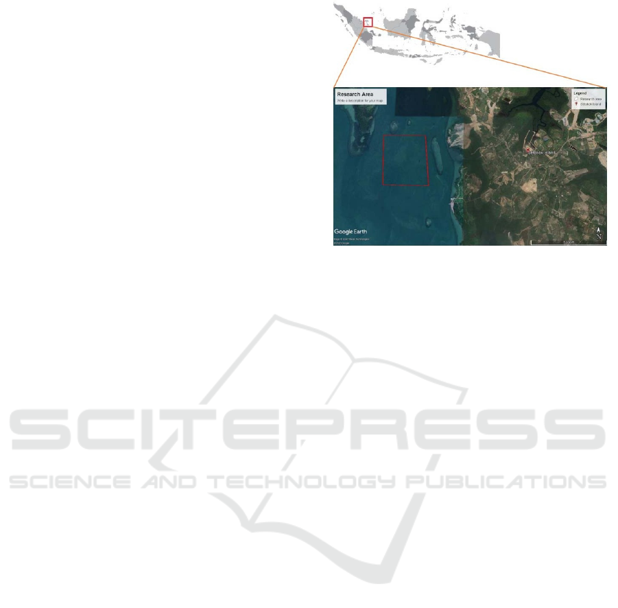
2.1 Research Location
This research was conducted in Setokok Sea. The
longitude and latitude coordinate is 104.031520° and
0.951068°, respectively. The area of study around 4
km
2
shown on the map in Figure 1.
2.2 Data Collection Technique
Terra Modis satellite imagery data, which is quite
well known for remote sensing, is Aqua / Terra.
MODIS (Moderate Resolution Imaging
Spectroradiometer) is an essential instrument in the
satellite Terra (EOS AM) and Aqua (EOS PM). The
MODIS Aqua / Terra satellite observes the earth's
entire surface every 1 to 2 days, obtaining data in 36
spectral band channels or groups of wavelengths
(Short, 2009; Sathyendranath, et al., 2012). MODIS
is also a satellite with a daily time series, so it is
appropriate for collecting the data (Sasmito, Parwati,
Budhiman, 2013).
Figure 1: Research location and area of study in Setokok
Sea, Batam.
In this study, data produced using recordings from
Terra MODIS satellite images for two months (April-
May 2020), with one season treatment (east season).
Additionally, data of Chlorophyll A distribution were
downloaded from https://oceancolor.gsfc.nasa.gov/.
The downloaded data was then processed by
combining them with the extracted Terra MODIS
image data. The sea surface temperature data is
obtained from extracted Terra MODIS Image data and
then classifying it for the appropriate data. These two
parameters are processed using SeaDAS and ODV
(Ocean Data View) software. Modis imagery has
three image data types, namely, Modis imagery level
1a, 1b, 2, and 3. This study uses MODIS imagery data
MODIS level 3.
2.3 Bathymetry
The bathymetry data acquisition technique is
conducted with observable data called a fixation point
with position and depth information. The bathymetry
measurements performed cannot be directly used
(processed) because it still contains data shortages
(tidal and transducer corrections) that are obtained at
the time of tidal data processing (tidal components) to
find out the actual depth appearance. The magnitude
of the tidal correction is the depth value (which has
been corrected by the transducer), which will be fixed
by the reduction value at the sea level position when
the measurement takes place. This data obtained from
the BIG Website (BATNAS)
(http://tides.big.go.id/DEMNAS/), downloaded for
two weeks in May 2020. The gridded BATNAS data
(National Bathymetry) are from 90 to 150 east
longitude and 20 southern latitudes to 20 northern
Ocean Colour Climate Change: Approach Identification of Sea Level and Physical Conditions in Setokok Sea
21
latitudes. This bathymetry data has advantages in
coastal areas and shallow sea by using a survey from
the BIG Center for Marine and Coastal Environment
(PKLP) (Geospatial Information Agency).
2.4 Tidal (sea level)
Tidal data acquisition techniques obtain from the BIG
Website (Geospatial Information
Agency)
(http://tides.big.go.id/) taken based on the location
point in May 2020. In determining the water level
change in the river, there are factors such as river
hydrology, height difference, and the position of the
flow from upstream to the estuary. Near the estuary,
the water level is influenced by the sea level changes.
Data analysis is generally grouped into several
sections based on the type of data used to calculate.
The tidal data analysis is performed using Least
Square to obtain the value of tidal harmonic
constants. According to Rampengan (2009), the
classification of tidal types is carried out by
comparing the amplitudes of diurnal constants (K1
and O1) with the amplitudes of semidiurnal constants
(M2 and S2). Formzahl numbers are used to
determine the type of tides that occur in the sea
(Hidayah & Fatmawati, 2010) with a formulation
presented in Equation (1).
𝐹 𝐴𝐾1 𝐴𝑂1/𝐴𝑀2 𝐴𝑆2
(1)
Where:
F = Formzahl,
AK1 = the amplitude of the average daily single
tidal wave affected by the declination of the
moon and the sun,
AO1 = the amplitude of a single daily tidal wave
that is affected by the declination of the
moon,
AM2 = amplitude of average double daily tidal wave
children affected by the moon,
AS2 = the amplitude of the average double daily
tidal wave affected by the sun.
According to Oktavia, Pariwono, Manurung
(2011), the F value determines the characteristic of
tidal wave. The F value of 0 <F 0.25: semidiurnal;
0.25 <F 1.50: mixed tide prevailing semidiurnal; 1.50
<F 3.00: mixed tide prevailing diurnal; F> 3.0:
diurnal.
3 RESULTS AND DISCUSSION
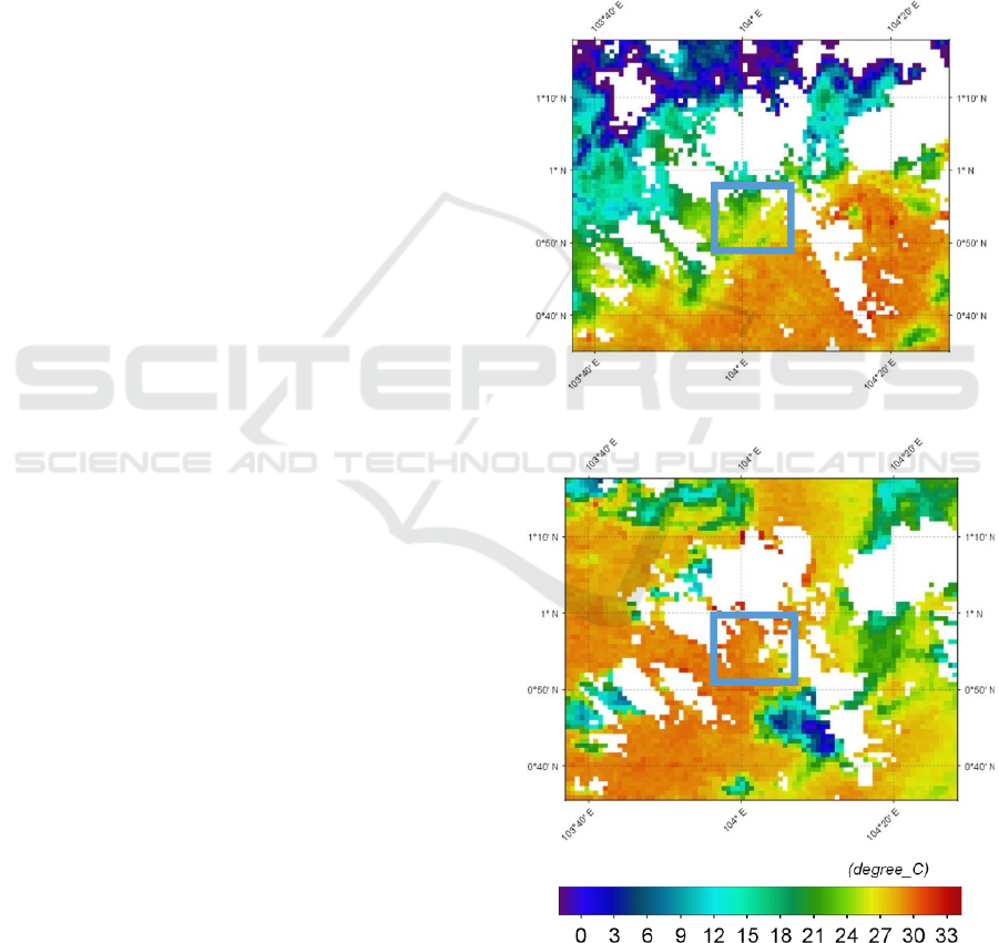
3.1 Sea Surface Temperature
Sea surface temperature data obtained from satellite
images of fashionable terra level 3 is shown in Figure
2, with the observed location marked with the blue
box. The data for sea surface temperature is obtained
for the period of April and May 2020 (east season).
The sea surface temperature is deemed as one of the
parameters that is affected by climate change.
(A)
(B)
Figure 2: A. Sea surface temperature (April 2020), B. Sea
surface temperature (May 2020). (the data are in
o
C)
ICAE 2020 - The International Conference on Applied Engineering
22
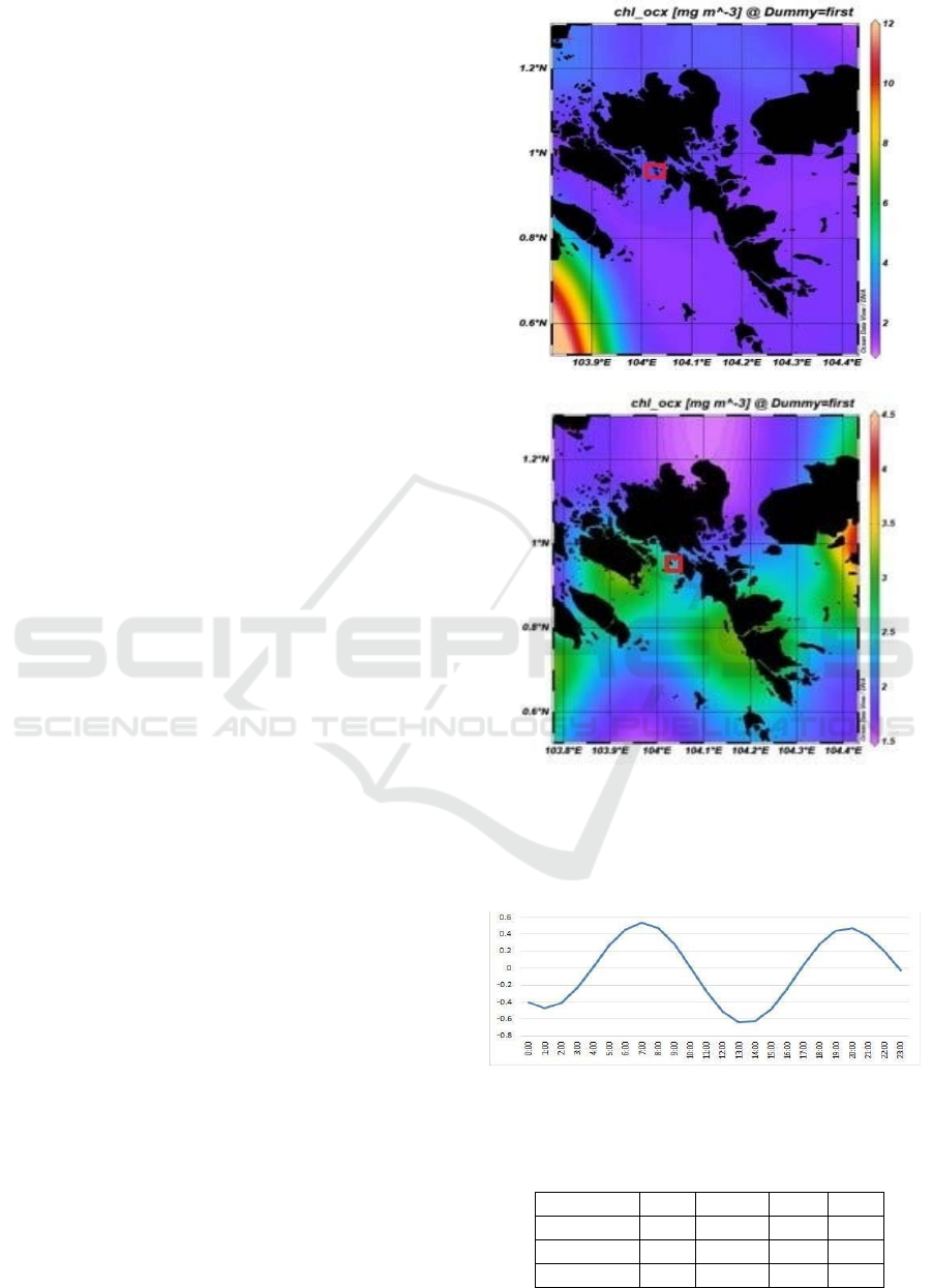
Figure 2 shows that the sea surface temperature is
28.7
o
C in April 2020 (A) and 29.8
o
C in May 2020
(B). These results indicate a difference in sea surface
temperature values between April and May 2020 in
Setokok Sea, with a decrease in sea surface
temperature of 0.9
o
C. This condition undoubtedly
affects the distribution of Chlorophyll A that occurred
in April and May 2020 (east season) due to the impact
of global climate change in 2020. The changes in sea
surface temperature due to currents, wind, water, and
waves turbidity, are commonly called ocean
dynamics. The upwelling process can also increase
Chlorophyll A content and decrease sea surface
temperature (Feng, Yao, Gu, Guo, 2007). According
to Surya, et al., (2017), sea surface temperature in
Batam is in the range of 29-31
o
C during January-
December period.
Figure 3 present the distribution of Chlorophyll A
is 3.5 mg/l in April 2020 (A) and 3.2 mg/l in May
2020. These results indicate a decrease of 0.3 mg/l in
the Chlorophyll A distribution in Setokok Sea. This
finding might be caused by the rising sea surface
temperature in Setokok Sea, which can decrease the
distribution of Chlorophyll A. According to Nontji
(2008), Chlorophyll A is an indicator of the
abundance of phytoplankton that becomes
zooplankton food to measure the productivity level of
primer water conditions. Hence, the decreasing
concentration of Chlorphyll A indicates the decreased
primary water productivity. Another study (Kunarso,
Hadi, Ningsih, Baskoro, 2011) has also suggested the
close relation between the Chlorophyll A levels with
the sea surface temperatures.
3.2 Tidal Analysis (sea level)
Tidal observations and measurements are made at the
coordinate of 1040 1 '50 " - 1040 2"35 " east longitude
and 00 56"35" - 00 57"32" north latitude. The sea in
Setokok tend to be double tilt or semi-diurnal (mixed
tide prevailing semi- diurnal), meaning that there are
two tides in a day, but the two pairs are not as large as
the tidal graphs shown in Figure 4.
The tidal component analysis is performed to
obtain the value of each tidal component's amplitude
and bead phase. The method used is the Least Square.
After the analysis is carried out, the constant
harmonic values obtained are presented in the Table
1.
(A)
(B)
Figure 3: A. Chlorophyll A distribution (April 2020), B.
Chlorophyll A distribution (May 2020).
Figure 4: Tidal wave chart (May 20, 2020).
Table 1: The value of amplitude (A) and phase (G) of the
harmonic constants of tidal wave studied.
Componen
t
M2 S2 N2 K2
Value
0.3527 0.3884 0.0731 0.3332
Componen
t
O1 P1 M4 MS4
Value
0.2673 0.1819 0.0112 0.0038
Ocean Colour Climate Change: Approach Identification of Sea Level and Physical Conditions in Setokok Sea
23
The data are taken in the second half of the month
in May 2020, where the moon's condition was convex
at the end of the month to the end of the month, or it
could be called a crescent. By entering these constant
values into the Formzahl number equation, an amount
of 0.81 will obtain. Based on this number, the type of
mixed tides tends to be Semidiurnal. It means that
there are two pairs of waves and two times receding
with different heights and periods in one day. The
dominant tidal components based on the above
calculation are the S2 and M2 component with an
amplitude value of 0.3884 and 0.3527, respectively. In
contrast, the non-dominant tidal element in MS4 with
an amplitude value of 0.0038 proves that the regional
tidal type is a mixed type. The amount of retroactivity
is influenced by intense sun penetration that affects
the sea surface temperature due to climate change
(Adibrata, 2007). By using the Least Square method,
the results obtained from tidal harmonic analysis are
harmonic components that can be used to determine
sea level elevation values. The results of sea-level
elevation in Setokok coastal seawater are:
Mean High Water Level during the observation
period is 1,860 meters.
Mean Sea Level, which is the mean water level
between the mean high water level and the mean
low water level. This elevation using as a
reference for elevation on land is 2,675 meters.
Mean Low Water Level is the lowest water
level at high tide.
According to Suhelmi (2013), the sea-level values
shows that the increase in tidal inundation area due to
sea-level rise plays a significant role in the amount of
vulnerability index. This is due to the relationship to
global climate change that occurs in water. Sea
surface anomalies are strongly influenced by tides,
topography, wind, ocean currents, density, and
seawater pressure, especially in Setokok Sea.
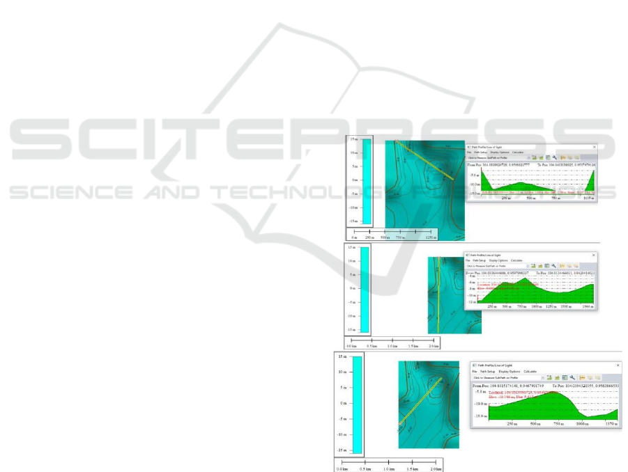
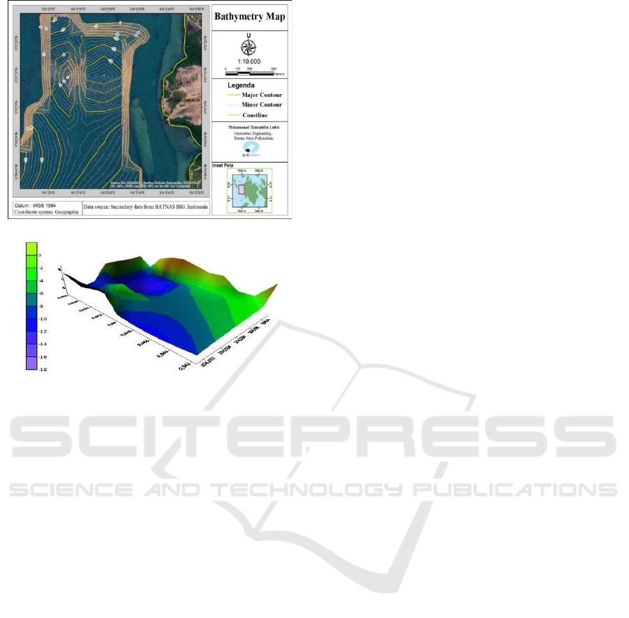
3.3 Cross-profile and Water
Bathymetry
The water cross-section profile shows a cross-section
of one of the samples in the area's coastal part, with a
relatively steep to the sloping surface. In Figure 5, it
can be seen that the height of the coastal surface
decreases as it heads towards the coast.
From Figure 5, the results of three samples taken in
the form of a cross-section, wherein example 1
illustrates that the surface is relatively steep in the
northern part of the study area and the southern part of
the study area. Whereas in samples 2 and 3, the site's
bottom surface looks slightly sloping compared to
sample 1. The 3-dimensional and 2- dimensional form
of bathymetry for the area of study of the water bottom
is shown in Figure 6.
The condition of the bathymetry of the sea in the
location indicates that the location is suitable for a
port and its support. The ship sailing activities
generally
requires water depth that is equal to the
ship's requirements (draft) plus different depth. Based
on the data observed, this water area is eligible for
shipping activities. The depth of the
port/pier/terminal water is usually determined from
the size of ships that are frequently entering the dock.
The giant ship that rarely comes could only enter the
port when the sea is in high tide. The depth of the ocean
around Batam Island is already mapped by BATNAS
BIG, which divided the area into four depth levels,
namely depth of 1-5 meters, 5-10 meters, 10-20
meters, and> 20 meters. Sea with the depth of 1-5
meters locates around the coast and spread throughout
Batam City. For the depth of 5-10 meters, categorized as
inter-island sea belong to the Regency of Batam and
other areas. The area with the depth of 1-5 meters are
included in the development of the coastal regions
while the area with the depth of 5-10 meters is
intended for shallow sea areas. The area with the
depth of 10-20 meters and >20 meters is for the
development of deep-sea areas.
Figure 5: The cross-sectional profile of Setokok Sea.
ICAE 2020 - The International Conference on Applied Engineering
24
(A)
(B)
Figure 6: Bathymetry of Setokok Sea (A) 2 dimensions, and
(B) 3 dimensions
Setokok Sea is part of the shallow area with the
depth distribution ranging from 0 to 16 meters below
sea surface. The deepest point locates at a distance of
16 m to the northeast while the lowest depth (0-5
meters) can be placed around the Setokok beach.
Setokok Sea has a relatively steep surface in the north
and south. On the east, the sea floor looks more
gentle. As for the coastal areas of Setokok, the surface
is relatively steep until the sloping height of the
coastal surface decreases as it heads towards the
coast. Thus, it can be seen that the sea level's value
must have a significant effect on the steepness of the
bathymetry in an area of water, especially in seawater
like Setokok. Hasan (2004) studied that other
important factors that can influence climate change
are the average topography and the value of the depth
of the ocean in water.
4 CONCLUSIONS
From the results of research conducted in one season,
it can show the difference in sea surface temperature
and the distribution of Chlorophyll A in April and May
2020 (east season). The higher the sea surface
temperature, the lower the Chlorophyll A's
distribution value in Setokok Sea. This is also related
to the sea level that changes every day, and
dramatically affects the bathymetry and steepness of
the transverse profile in Setokok Sea. The results
show climate change observed from the parameters
studied, namely the sea surface temperature, the
distribution of Chlorophyll A, tides (sea level), cross
profile, and bathymetry values. The change of those
parameters caused by global climate chage tend to
affect the primary water condition in Setokok Sea
Batam islands.
ACKNOWLEDGEMENTS
The authors thank Politeknik Negeri Batam for
facilitating this research by providing research grant
funds in the middle of research schemes (DIPA funds
in 2020).
REFERENCES
Adibrata, S., 2007. Analisis pasang surut di Pulau
Karampuang, Provinsi Sulawesi Barat. Akuatik: Jurnal
Sumberdaya Perairan, 1(1), 1-6.
Antoni, S., Bantan, R. A., Al-Dubai, T. A., Lubis, M. Z.,
Anurogo, W., Silaban, R. D., 2019. Chlorophyll A, and
Sea Surface Temperature (SST) as proxies for climate
changes: case study in Batu Ampar waters, Riau
Islands. In IOP Conference Series: Earth and
Environmental Science (Vol. 273, No. 1, p. 012012).
IOP Publishing.
Awak, D. S., Gaol, J. L., Subhan, B., Madduppa, H. H.,
Arafat, D., 2016. Coral reef ecosystem monitoring
using remote sensing data: case study in Owi Island,
Biak, Papua. Procedia Environmental Sciences, 33,
600-606.
Collins, M., An, S. I., Cai, W., Ganachaud, A., Guilyardi,
E., Jin, F. F., Vecchi, G., 2010. The impact of global
warming on the tropical Pacific Ocean and El Niño.
Nature Geoscience, 3(6), 391-397.
Dasanto, B. D., 2010. Penilaian dampak kenaikan muka air
laut pada wilayah pantai: Studi kasus Kabupaten
Indramayu. Jurnal Hidrosfir Indonesia, 5(2).
Feng, J., Yao, Z., Gu, M., Guo, H., 2007. The climate
change and its ecosystem effect in the upper yellow
river. In 2007 IEEE International Geoscience and
Remote Sensing Symposium (pp. 793- 796). IEEE.
Gaol, J. L., Leben, R. R., Vignudelli, S., Mahapatra, K.,
Okada, Y., Nababan, B., Syahdan, M., 2015. Variability
of satellite-derived sea surface height anomaly, and its
relationship with Bigeye tuna (Thunnus obesus) catch
in the Eastern Indian Ocean. European Journal of
Remote Sensing, 48(1), 465-477.
Ocean Colour Climate Change: Approach Identification of Sea Level and Physical Conditions in Setokok Sea
25

Hasan, S., 2004. Kepadatan dan pola distribusi
echinodermata di zona intertidal pantai pulau Ternate.
Media Ilmiah MIPA, 1(1), 1-9.
Hidayah, Z., Mahatmawati, A. D., 2010. Perbandingan
fluktuasi muka air laut rerata (MLR) di perairan pantai
utara Jawa Timur dengan perairan pantai selatan Jawa
Timur. Jurnal Kelautan: Indonesian Journal of Marine
Science and Technology, 3(2), 159-167.
Horhoruw, S. M., Atmadipoera, A. S., Nanlohy, P.,
Nurjaya, I. W., 2017. Anomaly of surface circulation
and Ekman transport in Banda Sea during ‘Normal’and
ENSO episode (2008-2011). In IOP Conference Series:
Earth and Environmental Science (Vol. 54, No. 1, p.
012041). IOP Publishing.
Kunarso, K., Hadi, S., Ningsih, N. S., Baskoro, M. S., 2011.
Variabilitas suhu dan klorofil-a di daerah upwelling
pada variasi kejadian ENSO dan IOD di perairan
selatan Jawa sampai Timor. ILMU KELAUTAN:
Indonesian Journal of Marine Sciences, 16(3), 171-
180.
Lubis, M. Z., Anurogo, W., Mufida, M. A., Taki, H. M.,
Antoni, S., Lubis, R. A., 2018. Physical condition of the
ocean to global climate change variability: case study
in the Batam waters, Indonesia. In 2018 International
Conference on Applied Engineering (ICAE) (pp. 1-4).
IEEE.
Nontji, A., 2008. Plankton laut, Yayasan Obor Indonesia.
Jakarta.
Oktavia, R., Pariwono, J. I., Manurung, P., 2011. Variasi
muka laut dan arus geostrofik permukaan perairan Selat
Sunda berdasarkan data pasut dan angin tahun 2008.
Jurnal Ilmu dan Teknologi Kelautan Tropis, 3(2), 127-
152.
Oude-Essink, G. H. P., Van-Baaren, E. S., de-Louw, P. G.
B., 2010. Effects of climate change on coastal
groundwater systems: A modeling study in the
Netherlands. Water resources research, 46(10).
Rampengan, R. M., 2009. Pengaruh pasang surut pada
pergerakan arus permukaan di Teluk Manado. Jurnal
Perikanan dan Kelautan Tropis, (3), 15-19.
Sasmito, B., Parwati, E., Budhiman, S., 2013. Analisis
distribusi total suspended matter dan Klorofil-a
menggunakan citra terra modis level 1b resolusi 250
meter dan 500 meter (studi kasus daerah pesisir
Kabupaten Pesawaran Provinsi Lampung tahun 2012).
Jurnal Geodesi Undip, 2(1).
Sathyendranath, S., Brewin, B., Mueller, D., Doerffer, R.,
Krasemann, H., Mélin, F., Steinmetz, F., 2012. Ocean
colour climate change initiative—Approach and initial
results. In 2012 IEEE International Geoscience and
Remote Sensing Symposium (pp. 2024- 2027). IEEE.
Short, N. M., 2009. The remote sensing tutorial: the
concept of remote sensing. Retrieved March 23
rd
, 2020,
from
http://geoinfo.amu.edu.pl/wpk/rst/rst/Front/overview.h
tml
Suhelmi, I. R., 2013. Pemetaan kapasitas adaptif wilayah
pesisir Semarang dalam menghadapi genangan akibat
kenaikan muka air laut dan perubahan iklim. Forum
Geografi, 27 (1), pp. 81-92.
Surya, G., Khoirunnisa, H., Lubis, M. Z., Anurogo, W.,
Hanafi, A., Rizky, F., Mandala, G. F. T., 201).
Karakteristik suhu permukaan laut dan kecepatan angin
di perairan batam hubungannya dengan Indian Ocean
Dipole (IOD). Dinamika Maritim, 6(1), 1-6.
Susandi, A., Herlianti, I., Tamamadin, M., Nurlela, I., 2008.
Dampak perubahan iklim terhadap ketinggian muka
laut di wilayah Banjarmasin. Jurnal ekonomi
lingkungan, 12(2).
ICAE 2020 - The International Conference on Applied Engineering
26
