Design of Volcanic Educational-based Natural Tourism at Giriloyo,
Wukirsari Village, Imogiri District, Bantul Regency,
Yogyakarta-Indonesia
Sri Mulyaningsih
1
, Nur Widi Astanto Agus Tri Heriyadi
2
, Desi Kiswiranti
3
dan Muchlis
4
.
1,2,3
Geological Engineering of FTM-IST AKPRIND Yogyakarta,Jl. Kalisahak No. 28 Yogyakarta
Keywords: design, nature, tourism, ancient, and volcano
Abstract: Previous study determined Giriloyo was Tertiary ancient volcano. Dyke, lava, and andesitic breccia which
comprise this region strongly support the geological conditions, but the central facies of the ancient volcano
had already associated with so many cracks, so that need further geotecnical handlings. Design technic for
the geotecnical engineering is required to support it. This study aims to develop a geotechnical planning design
in the context of a potential landslide management. On the other hand, Giriloyo has a potential volcanic
educational-based tourism, supported with beautiful landscapes. The geotechnical planning design was
packaged in the form of educational-based natural tourism development. Research related to the purpose has
been carried out supported with geotechnical mapping to describe the carrying capacity. The results found
southwest-northeast normal faults (N290-320
o
E), north-south shear faults (0-15
o
E), and oblique normal faults
(northwest-southeast). All of them have potentially move to generate landslides. In anticipate the active rock
movements, sloping terraces into 25-30
o
to obtain safety factors of at least 1.5-1.8 have been designed. Thus,
the technical design to reduce the potential mass movements is addressed to obtain the natural cruising
tourism. The terraces are designed to expose 5 ancient volcanic stratums, i e. Central Facies Stratum, Dyke
Stratum, Lava with Hydrovolcanic Stratum, Lava with Collumnar Joints Stratum, and Agglomerates with
Autoclastic Breccia Stratum. Each of these stratums is connected with a multilevel educational pathway to
reduce burden on the land.
1 INTRODUCTION
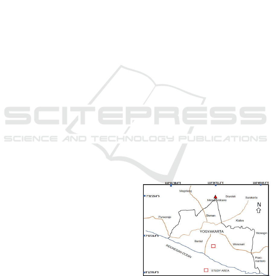
An ancient volcano was identified at Giriloyo,
Wukirsari Village, Imogiri District, Bantul Regency,
Yogyakarta Special Region (Figure 1). There was a
long periode of superimposed volcanism, building
Kebo-Butak Formation and Nglanggeran Formation,
during Early to late Middle Miocene (Mulyaningsih
et al., 2019). The exposed volcanic rocks were
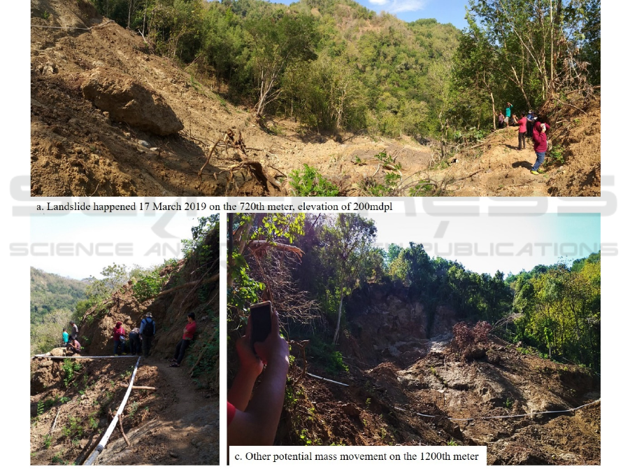
deformed generating active cracks that potentially to
move. A big landslide was noted in 17 March 2019,
remaining very wide sloping plane of 47
o
(Figure 2).
The slope was progressing to erode time by time, not
only by running water but also by the active fault.
Figure 1: Situation map of study area.
Mulyaningsih, S.
Design of Volcanic Educational-based Natural Tourism at Giriloyo, Wukirsari Village, Imogiri District, Bantul Regency, Yogyakarta-Indonesia.
DOI: 10.5220/0009435703490356
In Proceedings of the Second International Conference on Science, Engineering and Technology (ICoSET 2019), pages 349-356
ISBN: 978-989-758-463-3
Copyright
c
2020 by SCITEPRESS – Science and Technology Publications, Lda. All rights reserved
349
Dykes, lava, tuff, and andesitic breccia compose
Nglanggeran Formation, that covering older volcanic
rocks of Kebo-Butak Formation, exposed at
Watulumbung, near the landslide. While Kebo-Butak
Formation consists of black color of layered tuff,
palagonite tuff and lapillistone. About 40-60cm of
calcareous sedimentarry rocks of claystone and
sandstone intersected the Kebo-Butak Formation and
the Nglanggeran Formation, having ages of N5-6
(Early Miocene). So that the Kebo-Butak Formation
must be older than Early Miocene.
Actually, those volcanic rocks should strongly
support the geological conditions, but a high density
of deformations and weathering, so it become fragile.
It needs further geotechnical treatments. Design
technic after the geotechnical study in early step is
necesarry to assist the geotechnical engineering.
This study aimed to design the geotecnical
engineering, related to the mass movements
management. By the presence of the interesting
volcanic rocks of the central facies ancient volcano,
design of the geotechnical engineering should be
composed curously and arty. Those purpose to obtain
Giriloyo ancient volcano to be community-based
geotourism.
Figure 2: Landslaide happened on 17 March 2019 at the meter of 720th (a) and the potential landslides along the track of
Giriloyo (b,c).
2 METHOD
The study was started by geotechnical mapping with
surface and subsurface investigation. Those mapping
described lithology distributions, faults (deformation)
and the potential creeps, slumps and falls. Surface
mapping carried out by tracking, measuring and
compiling the geological data. Subsurface mapping
used microseismic soundings. This research used H/V
method, also called Nakamura technique. The device
was seismometer Lennartz Electronic with brand LE-
ICoSET 2019 - The Second International Conference on Science, Engineering and Technology
350

3Dlite, to describe the HVSR spectrum ratio
(~microzonation), following the formula is:
Site response analysis is important in seismic hazard
assessment such in earthquake prone zones (Bray and
Rodriguez-Marek, 2004) and mass movements.
Tohwata (2008) argued that microzonation can
predict the response and behaviour of soil and rocks
by the external energy around the soils/rocks.
Fifteen spots have sounded using H/V method.
The microseismic device identifed vibration decays
along the identified surface fault planes. This method
was intended to identify the distribution of the faults
below the surface. Along with the broadband
seismometer measuring in the real time, the vibration
were recorded using the main sources of hits
sounding into the medium. The ground movements
were verified as a function of time in local site.
Analysis and synthesis of research data is based
on all data that is compiled using the library data
collection system, then synthesized using overlie
system. Calculation and simulation of slopes is
carried out manually and computed using ESRI and /
MapInfo Arc-GIS software.
3 RESULTS
3.1 Secondary Data
Secondarry study found stratigraphy of study area
from the bottom to the top were Kebo-Butak, Semilir,
Nglanggeran, Sambipitu, Oyo and Wonosari
Formations (Elliezer et al., 2019; Rahardjo et al.,
1995; and Surono et al., 1992). The third earlier
mention were volcanic constituents. Kebo-Butak
Formation and Nglanggeran Formation were exposed
at study area (Mulyaningsih et al., 2019).
3.2 Field Data Record
Surface field mapping described Kebo-Butak
Formation consists of black tuff intersects with
brecciated and compacted basalt lava in about 60m
thickness. Above them are less calcareous sedimen-
tarry rocks consist of laminated tuffaceous claystone
and sandstone in about 60cm. Creammy color of
coarse tuff and lapillistone lie on the sedimentarry
rocks. That volcanic rocks are coarsening upward and
replaced with intersectings of thick layers of breccia,
lava and lapillistone in pyroxene-rich basalt
composition. The thickness of the volcanic sequence
is ~200m. Above them are agglomerate, andesitic
lava and dike (Figure 3), which is interpreted as
Nglanggeran Formation, as a product of constructive
phase volcanism occured within central facies. The
last volcanic rocks are exposed in the top of the track,
i.e. in the meter of 1000th at Watulumbung (1927th).
These volcanic rocks strongly supported the
geological conditions, but the inflation and deflation
during the volcanism located at the central facies had
already associated with the deformations. Mapping
recognized geological structures, consist right normal
slip faults. There are south-west-northeast normal
faults (N290-320
o
E), north-south shear faults (0-
15
o
E), and oblique normal faults (northwest-
southeast) (Figure 4a-b). All of them have potentially
move to generate landslides.
3.3 Subsurface Mapping
The soil vulnerability index (Table 1, Figure 5)
displays soil and rocks stability; the greater the
vulnerability value the smaller the soil/rocks
structure. The high vibration decays of the lections of
micrometer are found at S04-S07 with 33.2-45.55kgs
in the elevation of 134-186m asl
(Table 1, Figure 5).
Those corners are described having small values of
the soil vulnerability index, so that interpreted as
unstable conditions (movable). Low vibration decays
are found at S012-S015; that zone are interpreted
having higher vulnerability index, so that calculated
as more stable blocks.
Table 1: The mass vulnerability index recorded during
microseismic measurements.
Sta-
tion
Coordinate (m) Eleva-
tion
(m)
Vulnerability
Index (kgs)
South East
S01. 434823 9124498 50 32.45
S02. 434778 9124451 104 23.68
S03. 434783 9124362 146 18.42
S04. 434786 9124312 145 45.55
S05. 435126 9124308 186 38.75
S06. 435044 9124366 137 37.56
S07. 434995 9124430 134 33.12
S08. 434922 9124450 115 27.49
S09. 434845 9124597 105 16.54
S010. 434881 9124518 94 17.77
S011. 434759 9124693 103 21.45
S012. 434920 9124600 157 19.87
S013. 435055 9124516 211 17.55
S014. 435238 9124359 244 15.45
S015. 435255 9124336 262 12.73
Design of Volcanic Educational-based Natural Tourism at Giriloyo, Wukirsari Village, Imogiri District, Bantul Regency,
Yogyakarta-Indonesia
351
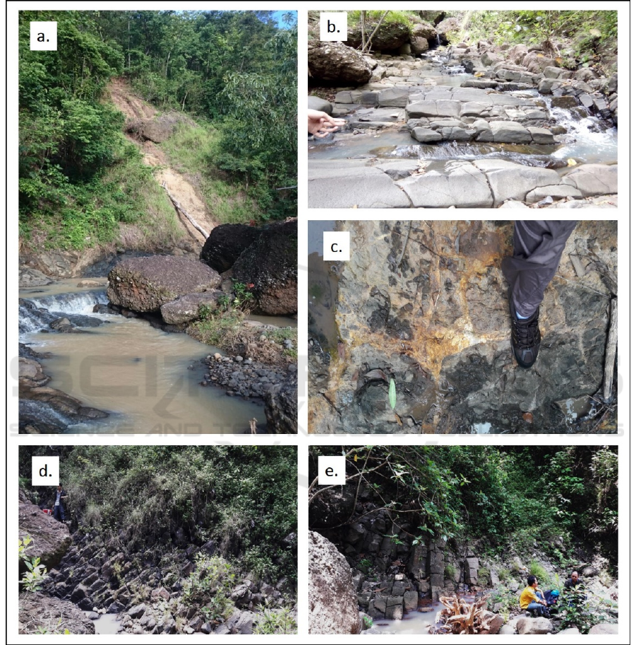
Figure 3: The volcanic rocks exposed at study area; a. Agglomerate; b. Dike; c. Altered rocks with sulphid minerals, d.
Volcanic neck; and e. Lava with collumnar joints. Those are used to deposited very close to the crater or within the crater.
ICoSET 2019 - The Second International Conference on Science, Engineering and Technology
352
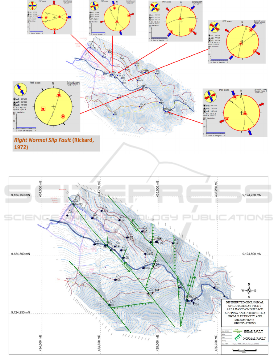
Figure 4a: The geological structure measured and computed at study area; the right normal slip faults.
Figure 4b: The distrubuted normal and right slip faults interpreted based on surface mapping and subsurface mapping using
dipole-dipole resistivity method and microseismic method.
Design of Volcanic Educational-based Natural Tourism at Giriloyo, Wukirsari Village, Imogiri District, Bantul Regency,
Yogyakarta-Indonesia
353
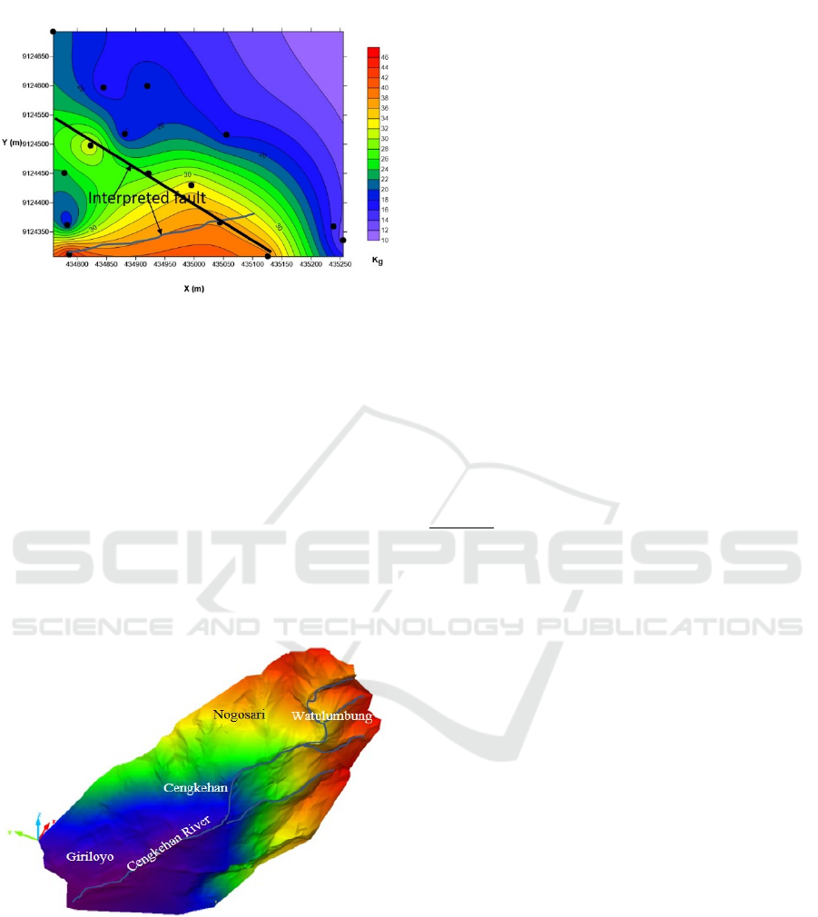
Figure 5. Map of vulnerability index at study area
interpreted from microseismic soundings.
3.4 Geomorphological Analyses
Geomorphology of study area are characterized by
gently to undulating topography sloping to 5-10
o
(at
Giriloyo), undulating to steeply at Cengkehan to
Nogosari (sloping between 10-30
o
), roughy elevated
hills near upper Nogosari, Watulumbung and
Grenjeng (~30-60
o
) and very steeply scarpments with
~60-70
o
on upper cliffes (Figure 6). The scarpments
are impending to fall (Figure 2). Creeps are
recognized along Grenjeng and lower Bukit Makbul
(Figure 2).
Figure 6: Digital Elevation Model (DEM) at study area.
4 DISCUSSION
Both surface and subsurface mappings recorded
active faults that potential moving at study area.
According to the data, whenever and at any time, such
in water saturated condition (in rainny sesion), it will
immediately collapse. Sloping will reduce the rate of
mass movement. Design for the hazard mitigation is
necesarry following the potential landslide/ rock falls.
It’s following the internal shear angle (ɸ), the density
of soil/rocks (γ),
cohesion (c) and water contents (ω).
Terraces will be also able to minimize the impact
caused by the mass movements. Technically,
designing terrace are following Figure 7.
The problems are how to manage the slope
stability, at once the kinds of strategic management in
protecting the geoheritage related to the Giriloyo-
Cengkehan’s ancient volcano phenomenon. Safe
storage with good aesthetics can be done through the
terracing. Making artistic terraces will not only
reduce the rate of mass movements but also add to the
aesthetics of the study area. Slope management can
be improved through risk analysis and systematic
assessment of slope stability.
Terrace morphometry has been analyzed based on
size, width (horizontal/horizontal interval (HI)) and
distance of each edges (vertical distance/vertical
interval (VI)). The terrace interval (HI) was assumed
according to the ease of anthropogen activities. The
size of terrace (VI) was calculated using the equation
of FAO (1986, in Blanco, 2008) as follows.
∗
∗
= where as VI = vertical distance (m), Wb =
terrace width (m), hereinafter referred to as HI (m); S
= slope (%) and U = HI and VI ratio (using 0.75 for
manually built terraces (Blanco, 2008). So that it was
calculated that slopes of ≤20
o
is advisable a distance
to be 15m; while slopes of ~30
o
should be more than
10m distance. Bennett's criteria to calculate distances
between terraces are the more advisable being closely
related with experimental results in the area. Each
terrace consists of 5m for landfill, 5m bamboo parks
with landfilling to the top, the last 5m is keep to be
the original slopes. The overall slope has changed to
~20
o
in the teak garden, and ~35
o
around the 1.5-5m
and obtain safety factor of 1.5-1.8 for the sloping
terraces.
Bamboo park is chosen to be an effective soil
conservation at study area. Bamboo groves can
maintain land and groundwater stability. The dense
bamboo root system, which spreads in all directions,
is able to strengthen the stability of the land, and rain
water is easier to infiltrate into bamboo-covered soil.
Bamboo stems have advanced natural capillary,
which absorbs and stores water. Bamboo is able to
release 35% oxygen and is a very useful plant in terms
of reforestation of unproductive or degraded land.
Planting bamboo at study area as land conservation is
designed take place in the tarrace planes (Figure 7.a),
while the hillslopes are designed as a retaining walls
(Figure 7.b).
ICoSET 2019 - The Second International Conference on Science, Engineering and Technology
354
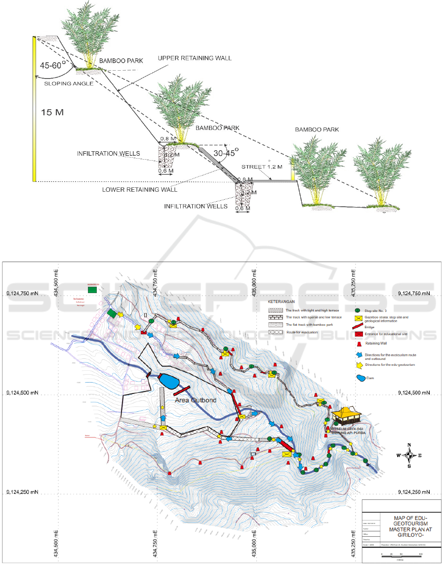
Figure 7: Design for the terracing (grounding) the slopes in reducing mass movements
Figure 8: Design of the volcanic educational-based tourism at study area; as a conservation plan to manage landslide and
other potential mass-movements.
Design of Volcanic Educational-based Natural Tourism at Giriloyo, Wukirsari Village, Imogiri District, Bantul Regency,
Yogyakarta-Indonesia
355

5 CONCLUSIONS
Study area has potential mass-movements, such as
landslides. It threats to the civilization below the
slopes. But study area also potential with special
interest of ancient volcanological tourism. Land
conservaton and developing heritages (land, culture
and geology) is designed following the natural
resources and their potential movements. Terracings
are chosen to be developed at study area. Those are
designed by sloping landscape into 20-35
o
, to obtain
slope stability under safety factor of 1.5-1.8.
ACKNOWLEDGEMENTS
Our greetings attend to the Ministry of Research
and High Education (RISTEKDIKTI) which was
funding the research by the first and second years of
Penelitian Terapan Unggulan Perguruan Tinggi
(PTUPT Scema) on 2018-2019. Special gratitudes
tend to the goverment of Bantul Regency, the head
and staff of Wukirsari, the Giriloyo and Cengkehan
communities, POKDARWIS, as well as FORCIB
ARYABHATA, who have provided the research
facilities, accompanied the research and gave a
variety of very warm supports. A big appreciation is
supervised to LPPM IST AKPRIND Yogyakarta for
the opportunities to reach the PTUPT grant.
REFERENCES
Arce, J.L., Walker, J. and Keppie, J.D., (2014). Petrology
of two contrasting Mexican volcanoes, the Chiapanecan
(El Chichón) and Central American (Tacaná) volcanic
belts: the result of rift-versus subduction-related
volcanism. International Geology Review, 56(4),
pp.501-524.
Bray, J.D. and Rodriguez-Marek, A., 2004.
Characterization of forward-directivity ground motions
in the near-fault region. Soil dynamics and earthquake
engineering, 24(11), pp.815-828.
Budayana, I.G.N.M, (2017). Geologi dan Identifikasi
Fasies Gunung Api Berdasarkan Stratigrafi Batuan di
Daerah Mangunan dan Sekitarnya, Kecamatan Dlingo,
Kabupaten Bantul Daerah Istimewa Yogyakarta,
Laporan Sripsi Tipe-1, 2017; tidak dipublikasikan.
Edwards, R.N., 1997. On the resource evaluation of marine
gas hydrate deposits using sea-floor transient electric
dipole-dipole methods. Geophysics, 62(1), pp.63-74.
Eliezer, I., Winarno, T. and Ali, R.K., 2019. Petrogenesis
Lava Bantal Nampurejo di Dusun Kalinampu Dan
Sekitarnya, Desa Jarum, Kecamatan Bayat, Kabupaten
Klaten, Provinsi Jawa Tengah. Jurnal Geosains dan
Teknologi, 2(1), pp.33-41.
Hadian, M.S.D., Yuliwati, A.K. and Pribadi, K.N., (2016).
Increasing community environmental awareness
through geodiversity conservation activities at Ciletuh,
Sukabumi, West Java. Journal of Environmental
Management & Tourism, 7(2), p.14.
Hermawan, H. and Brahmanto, E., (2017). Geowisata:
Perencanaan Pariwisata Berbasis Konservasi.
Hermawan, H., (2018). Geowisata Sebagai Model
Pemanfaatan Kekayaan Geologi Yang Berwawasan
Lingkungan. Jurnal online (STP AMPTA Yogyakarta,
diakses tanggal 23 April 2018).
Hermawan, H. and Ghani, Y.A., (2018). Geowisata: Solusi
Pemanfaatan Kekayaan Geologi Yang Berwawasan
Lingkungan. Jurnal Sains Terapan Pariwisata, 3(3),
pp.391-408.Mulyaningsih, S., Blessia, S., Tania, D. and
Heriyadi, N.W.A.A.T., 2019. Studi Fasies Gunung Api
Purba Gunung Ireng, Desa Pengkok, Kecamatan Patuk,
Kabupaten Gunungkidul-DIY. Jurnal Teknomineral,
1(1), pp.15-23.
Mulyaningsih, S., Suhartono, dan Mindayani, E., (2019b).
Kajian Potensi Pengembangan Jalur Jelajah Alam
Geologi gunung Api Purba Giriloyo-Imogiri, Jurnal
Riset Daerah, in press.
Pamuk, E., Özdağ, Ö.C., Özyalın, Ş. and Akgün, M., 2017.
Soil characterization of Tınaztepe region
(İzmir/Turkey) using surface wave methods and
Nakamura (HVSR) technique. Earthquake Engineering
and Engineering Vibration, 16(2), pp.447-458.
Permadi, R., Rachwibowo, P. and Hidajat, W.K., (2014).
Potensi Situs-Situs Warisan Geologi di Area Kars
Gunung Sewu sebagai Pendukung dan Peluang
Pengembangan Geopark di Indonesia untuk Aset
Geowisata Kreatif. Geological Engineering E-Journal,
6(2), pp.586-601.
Picozzi, M., Parolai, S. and Albarello, D., 2005. Statistical
analysis of noise horizontal-to-vertical spectral ratios
(HVSR). Bulletin of the Seismological Society of
America, 95(5), pp.1779-1786.
Shapiro, N.M., Campillo, M., Stehly, L. and Ritzwoller,
M.H., 2005. High-resolution surface-wave tomography
from ambient seismic noise. Science, 307(5715),
pp.1615-1618.
Sheng, D., Fredlund, D.G. and Gens, A., 2008. A new
modelling approach for unsaturated soils using
independent stress variables. Canadian Geotechnical
Journal, 45(4), pp.511-534.
Smyth, H.R., Hall, R. and Nichols, G.J., (2008). Cenozoic
volcanic arc history of East Java, Indonesia: the
stratigraphic record of eruptions on an active
continental margin. Special Papers-Geological Society
of America, 436, p.199.
Surono, B.T. and Sudirno, I., (1992). Peta Geologi Lembar
Surakarta-Giritontro. Jawa.(1408-3), Skala 1: 100000
Towhata, I., 2008. Geotechnical earthquake engineering.
Springer Science & Business Media.
ICoSET 2019 - The Second International Conference on Science, Engineering and Technology
356
