
Aerial Photogrammetry and Object-based Image Analysis for Bridge
Mapping: A Case Study on Bintan Bridge, Riau Islands, Indonesia
Husnul Kausarian
1
, Muhammad Zainuddin Lubis
2
, Primawati
3
, Dewandra Bagus Eka Putra
1
, Adi
Suryadi
1
and Batara
1
1
Department of Geological Engineering , Universitas Islam Riau, Pekanbaru, Indonesia
2
Department of Informatics Engineering, Politeknik Negeri Batam, Batam-Kepulauan Riau, Indonesia
3
Mechanical Engineering, Engineering Faculty, Universitas Negeri Padang, Padang-West Sumatra, Indonesia
adisuryadi}@eng.uir.ac.id, batarabtr@gmail.com
Keywords:
Photogrammetry, Unmanned Aerial Vehicle (UAV), Bintan Bridge, Structure, Specify Second Distance.
Abstract:
Photogrammetry is a good method for determining the geometric properties of an object from the images. The
geometry of the object obtained from two or more drawings that are overlaid. It is completely autonomous,
ultra-lightweight so-called Unmanned Aerial Vehicle (UAV) which has been commercially available at very
economical prices in the community or researchers, and photogrammetric applications. The study area was
located at Bintan Island, Riau Islands Province, Indonesia, collecting data on 8th may, 2017 (1
◦
3’45.98”N
- 104
◦
27’49.22”E), with DJI phantom 4 including control range small format air photography (SFAP) which
is a low-cost, cost-effective solution for obtaining bridge surface imagery and can also be proposed as a
long-distance bridge inspection technique to complement the current bridge visual inspection in Indonesia.
Some examples of evaluations on bridges using SFAP are presented to provide remote sensing information
and capabilities that serve as an essential tool for monitoring and assessing the construction of the bridge.
The measurement of Bintan Bridge is 193 m, the photos were taken from the airplanes around 70 meters and
providing top-down views. Bintan Bridge’s structure have specify second distance in left wide is 1.057 <
1560, and specify second distance in right wide is 0.9981 < 1570.
1 INTRODUCTION
Modelling on object information with building in-
stances becomes a famous technology for some in-
frastructure such as bridges, road systems, tunnels,
dams, water, and sewage networks. In the Riau Is-
lands, Bintan Island does not have much informa-
tion on mapping air information using remote sensing
techniques on building any object, and buildings mod-
elling information is very limited. The latest map-
ping information on the Riau islands is still domi-
nantly small, and still in the general mapping of ob-
jects such as sea grass beds, settlements, seafloor (Lu-
bis and Daya, 2017; Lubis et al., 2017; Farizki and
Anurogo, 2017; Kausarian et al., 2016b; Kausarian
et al., 2016a; Kausarian et al., 2017; Kausarian et al.,
2018; Kausarian et al., 2019).
In terms of the image analysis, the contempo-
rary and existing construction is one of the signifi-
cant problem (Agapiou et al., 2015; Patraucean et al.,
2015; Tang et al., 2010; Volk et al., 2014; Cuca
et al., 2014; Kausarian et al., 2017). The mapping
on the current geomorphology field relies more and
more on automatic techniques that serve to classify an
image from the results of remote sensing techniques
and a digital elevation model (DEMs) (Lardeux et al.,
2016). Parameters are seen in the morphometric sec-
tion, such as the slope or curvature of the region or
the inherited object for the result of characterization
of the shape and result of the geomorphological pro-
cess. Arithmetic in the process of operation with the
drawing band can clarify the class on a particular ob-
ject. The vegetation index is often also used to clas-
sify vegetation and separate objects from other classes
in a remote sensing data. In the object image of the
entity on the basic technique in the drawing (in our
case is the bridge), in each group of objects in the im-
age, the pixel results consist of the same digital value,
and has a relationship to the intrinsic size and shape,
and the intrinsic ecology real-world scene component
is a model (Hay et al., 2001). In the results of a re-
cent study informed by the American Civil of Society
Kausarian, H., Lubis, M., Primawati, ., Putra, D., Suryadi, A. and Batara, .
Aerial Photogrammetry and Object-based Image Analysis for Bridge Mapping: A Case Study on Bintan Bridge, Riau Islands, Indonesia.
DOI: 10.5220/0009185802370242
In Proceedings of the Second International Conference on Science, Engineering and Technology (ICoSET 2019), pages 237-242
ISBN: 978-989-758-463-3
Copyright
c
2020 by SCITEPRESS – Science and Technology Publications, Lda. All rights reserved
237

(Chen et al., 2009) indicate that conditions improve
on all systems in the current infrastructure, with ob-
jects such as roads and bridges.
UAVs have been used successfully in a research,
for mapping (Hardin and Jackson, 2005; Kausarian
et al., 2018), for the nitrogen and biomass measure-
ment in a plant object (Izumi et al., 2018; Izumi et al.,
2019; Widodo et al., 2018; Widodo et al., 2019),
for document the crop at the value of water pressure
(Berni et al., 2009), and for results on rangeland veg-
etation mapping. In this study, we were interested in
the utilization of aerial mapping object-based image
(Bintan Bridge) for structure and position analyst in
Kepri islands, Indonesia
2 DATA AND METHODS
2.1 Study Location
Our study site was located on Bintan Island, Riau Is-
lands, Indonesia, collecting data on 8th May 2017 (
1
◦
3’45.98”N - 104
◦
27’49.22”E) (Figure 1). The area
over which imagery was acquired was located within
1.5 km of is Bintan Bridge.
2.2 Study Location
Agisoft Photoscan Professional version 1.2.7 build
3100 64 bit was used to extract all mosaic from quad-
copter DJI phantom 4 (Figure 2) and the tiles of
point cloud data converted into photogrammetry im-
ages. The 1-m resolution DTM used for normalizing
the terrain model on the object based images (Bintan
Bridge) height, and photo captured of Bintan Bridge
with altitude 70 meters can be seen in Figure 2.
2.3 Flight Planning
The take-off and landing operations are strongly
linked to the vehicle and the level of characteristics
employed, but can usually be controlled from the
ground by the pilot (e.g. with a remote controller).
Research mission (aviation and data acquisition) is
planned in laboratory with special software, starting
from the area of interest (AOI), the distance of re-
quired soil sample (GSD) or path, and knowing what
is the intrinsic parameter of camera digital installed
from DJI Phantom 4. During the flight process, the
platform is usually observed with a control station
showing real-time flight data such as position, speed,
stance and distance, GNSS observations, battery or
fuel status, rotor speed, altitude, etc.
3 RESULT AND DISCUSSION
Nearly 325 images (Figure 4) obtained through pho-
togrammetry and object-based image analysis (Bintan
Bridge) in Figure 3. 4-rotor quadcopter DJI phantom
4 with GNSS addition system equipped with 12 MP
pixel camera, GPS & GLONASS satellite system, -
90
◦
to + 30
◦
Pitch Gimbal Control Range. The mea-
surement of the Bintan Bridge is 193 m, measured by
Agisoft software, in solid mode and in shaded mode
as shown in Figure 4.
Image objects for each individual on the bridge
are simultaneously archived for viewing in a geo-
graphic information system (GIS) (Ellenberg et al.,
2016; Yeum and Dyke, 2015; Reagan et al., 2018).
The technique used in the results is ”manually match-
ing features” with mosaic images already available
from ArcMap 10.2 and Agisoft Photoscan Profes-
sional. The classification process is used to extract the
information performed by clarifying different colours
to each object class to distinguish them by rapid iden-
tification. Figure 4 shows the results of the object
detection of the bridge structure shown as a feature
with darker pixels than surrounding adjacent images
and may be marked as possible identification objects.
By viewing the surface with visuals and other surface
conditions may also appear like cracks seen in bridge
structures and figures. The same problem will arise
if the colour identification technique used on the sur-
face of the concrete. The flight crew must function
after the process of airing and flying near the point of
the camera direction that has been set for each bridge.
Accurate communication of the cockpit and air traffic
control officer is essential in completing the research
safely. Identifying the large and wide bridge objects
on the surface is relatively easy to observe. Analy-
sis of the bridge object and counting the width using
the method of air photography effectively identifies
the width which is 6 m and signed as a yellow colour
in Figure 5 which is also shows the condition of the
bridge connection and expansion.
The length of Bintan Bridge is 193 m from image
processing using Agisoft Software (Figure 4). Exten-
sive recapitulation of the entire procedure for generat-
ing the same 3D cloud point as the results of this study
can be found on applying the Scale Invariant Feature
Transform (SIFT) to perform button detection as in-
troduced (Lowe, 2004). The existence of field process
that occurs in traffic on the highway is always outside
the control of the flight pilot to take the photos. The
area of the sweep by the pilot in the process of traffic
can be such that large areas on the road surface are
not blocked by car objects. When performing aerial
photography analysis for this study, 2 (two) cars were
ICoSET 2019 - The Second International Conference on Science, Engineering and Technology
238
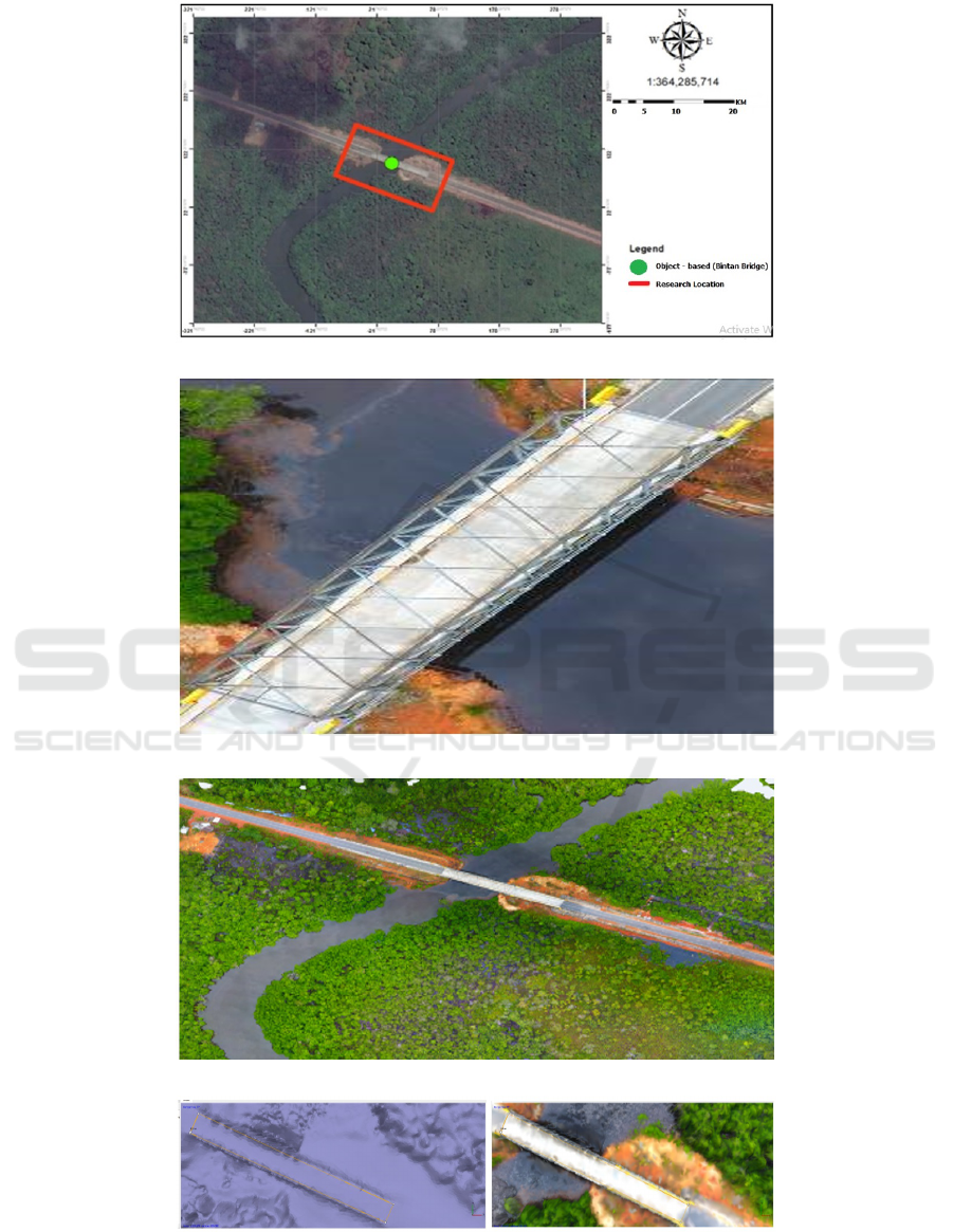
Figure 1: The Map of Research location and Object Based (Modified from Google Earth).
Figure 2: The image of Bintan Bridge, captured by Quadcopter DJI Phantom 4.
Figure 3: The point cloud computed with PhotoScan.
Figure 4: Automated image perspective 30 0 results for the UAV, left: with solid mode, right: with shaded mode.
present at the bridge statically. Taking vehicles from aerial photography is required (Figure 6). Structure
Aerial Photogrammetry and Object-based Image Analysis for Bridge Mapping: A Case Study on Bintan Bridge, Riau Islands, Indonesia
239
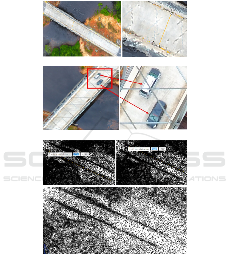
Figure 5: Aerial track object identification, left: original image, right: zoomed image.
Figure 6: Detection of two vehicles, left: original image, right: zoomed image.
Figure 7: Above: Structure of Bintan Bridge, left below: Specify Second Distance in Left Wide (1.057 < 1560), right below:
Specify Second Distance in Right Wide (0.9981 < 1570).
of Bintan Bridge can be seen in Figure 7 that have
specify second distance in left wide in range 1.057
< 1560, and specify second distance in right wide is
0.9981 < 1570.
4 CONCLUSIONS
In this study, remote sensing is used as a tool in or-
der to see the structure of Bintan Bridge with high-
resolution air photography. The procedures of image
processing and data collection as a detailed process
are described. The results of this study indicate that
ICoSET 2019 - The Second International Conference on Science, Engineering and Technology
240

the technology of remote sensing is able to detect very
clear objects and bridge structures. Accurate posi-
tioning and tracking results through bridges are done
without a robust test and the use of GPS units included
in the Instruments used on the correct scale to suit the
needs. It is necessary for pilots to remember that the
wide area augmented system (WAAS) enables GPS
accuracy of up to 6-8 inches/pixels. In this paper, we
discuss the process of making the whole drawing on
the object of the bridge by separating other objects,
including plants, etc. to keep in view the focus of the
Bintan bridge structure results, and the vehicles of the
aerial photogrammetr.
ACKNOWLEDGEMENTS
This study is supported by P2M, Geomatics Engi-
neering Program, Batam State Polytechnic, Kepu-
lauan Riau, Indonesia, and Engineering Geological
Program, Universitas Islam Riau.
REFERENCES
Agapiou, A., Lysandrou, V., Alexakis, D. D., Themisto-
cleous, K., Cuca, B., Argyriou, A., Sarris, A., and
Hadjimitsis, D. G. (2015). Cultural heritage manage-
ment and monitoring using remote sensing data and
GIS: The case study of Paphos area. Cyprus.
Berni, J. A., Zarco-Tejada, P. J., Surez, L., and Fereres, E.
(2009). Thermal and narrowband multispectral re-
mote sensing for vegetation monitoring from an un-
manned aerial vehicle. IEEE Transactions on Geo-
science and Remote Sensing.
Chen, S. E., Hauser, E., Eguchi, R., Liu, W. Q., Rice, C.,
Hu, Z., Boyle, C., and Chung, H. (2009). Bridge
health monitoring using commercial remote sensing.
In Proceedings, 7th International Workshop on Struc-
tural Health Monitoring, Stanford, CA.
Cuca, B., Agapiou, A., Kkolos, A., and Hadjimitsis, D.
(2014). Integration of innovative surveying technolo-
gies for purposes of 3D documentation and valorisa-
tion of St. Herakleidios Monastery in Cyprus.
Ellenberg, A., Kontsos, A., Moon, F., and Bartoli, I.
(2016). Bridge related damage quantification using
unmanned aerial vehicle imagery. Structural Control
and Health Monitoring.
Farizki, M. and Anurogo, W. (2017). Pemetaan kuali-
tas permukiman dengan menggunakan penginderaan
jauh dan SIG di kecamatan Batam kota. Batam.
Hardin, P. J. and Jackson, M. W. (2005). An unmanned
aerial vehicle for rangeland photography. Rangeland
Ecology & Management.
Hay, G. J., Marceau, D. J., Dube, P., and Bouchard, A.
(2001). A multiscale framework for landscape analy-
sis: object-specific analysis and upscaling. Landscape
Ecology.
Izumi, Y., Widodo, J., Kausarian, H., Demirci, S., Taka-
hashi, A., Razi, P., Nasucha, M., Yang, H., and J., T.
S. S. (2019). Potential of soil moisture retrieval for
tropical peatlands in Indonesia using ALOS-2 L-band
full-polarimetric SAR data. International Journal of
Remote Sensing.
Izumi, Y., Widodo, J., Kausarian, H., Demirci, S., Taka-
hashi, A., Sumantyo, J. T. S., and Sato, M. (2018).
Soil moisture retrieval by means of adaptive polari-
metric two-scale two-component model with fully po-
larimetric ALOS-2 data. In IGARSS 2018-2018 IEEE
International Geoscience and Remote Sensing Sympo-
sium. IEEE.
Kausarian, H., Lei, S., Lai, G. T., Cui, Y., and Suryadi, A.
(2019). A New Geological Map of Formation Distri-
bution on Southern Part of South China Sea:; Natuna
Island. Indonesia, In IOP Conference Series.
Kausarian, H., Sumantyo, J. T. S., Kuze, H., Karya, D., and
Panggabean, G. F. (2016a). Silica Sand Identification
using ALOS PALSAR Full Polarimetry on The North-
ern Coastline of Rupat Island. Indonesia.
Kausarian, H., Sumantyo, J. T. S., Kuze, H., Karya, D.,
and Wiyono, S. (2016b). The origin and distribution
of silica mineral on the recent surface sediment area.
Northern Coastline of Rupat Island, Indonesia.
Kausarian, H., Sumantyo, J. T. S., Putra, D. B. E., Suryadi,
A., and Gevisioner (2018). Image processing of alos
palsar satellite data. small unmanned aerial vehicle
(UAV), and field measurement of land deformation.
Kausarian, H., Sumantyo, S., T., J., Kuze, H., Aminuddin,
J., and Waqar, M. M. (2017). Analysis of polarimetric
decomposition. backscattering coefficient, and sample
properties for identification and layer thickness esti-
mation of silica sand distribution using L-band syn-
thetic aperture radar.
Lardeux, P., Glasser, N., Holt, T., and Hubbard, B. (2016).
Glaciological and geomorphological map of Glacier
Noir and Glacier Blanc. French Alps.
Lowe, D. (2004). Distinctive image features from scalein-
variant keypoints. International Journal of Computer
Vision.
Lubis, M. Z., Anurogo, W., Khoirunnisa, H., Irawan, S.,
Gustin, O., and Roziqin, A. (2017). Using Side-Scan
Sonar instrument to Characterize and map of seabed
identification target in punggur sea of the Riau Is-
lands. Indonesia.
Lubis, M. Z. Z. and Daya, A. P. (2017). Pemetaan Param-
eter Oseanografi Fisik Menggunakan Citra Landsat 8
di Wilayah Perairan Nongsa Pulau Batam. Jurnal In-
tegrasi.
Patraucean, V., Armeni, I., Nahangi, M., Yeung, J., Brilakis,
I., and Haas, C. (2015). State of research in automatic
as-built modelling. Advanced Engineering Informat-
ics.
Reagan, D., Sabato, A., and Niezrecki, C. (2018). Feasi-
bility of using digital image correlation for unmanned
aerial vehicle structural health monitoring of bridges.
Structural Health Monitoring.
Aerial Photogrammetry and Object-based Image Analysis for Bridge Mapping: A Case Study on Bintan Bridge, Riau Islands, Indonesia
241

Tang, P., Huber, D., Akinci, B., Lipman, R., and Lytle, A.
(2010). Automatic reconstruction of as-built building
information models from laser-scanned point clouds:
A review of related techniques. Automation in Con-
struction.
Volk, R., Stengel, J., and Schultmann, F. (2014). Build-
ing Information Modeling (BIM) for existing build-
ings Literature review and future needs. Automation
in Construction.
Widodo, J., Izumi, Y., Takahashi, A., Kausarian, H., Kuze,
H., and Sumantyo, J. T. S. (2018). Detection of dry-
flammable peatland area by using backscattering coef-
ficient information of ALOS-2 data L-band frequency.
In 2018 Progress in Electromagnetics Research Sym-
posium (PIERS-Toyama), IEEE.
Widodo, J., Izumi, Y., Takahashi, A., Kausarian, H.,
Perissin, D., and Sumantyo, J. T. S. (2019). Detection
of Peat Fire Risk Area Based on Impedance Model and
DInSAR Approaches Using ALOS-2 PALSAR-2 Data.
IEEE Access.
Yeum, C. M. and Dyke, S. J. (2015). Vision-based
automated crack detection for bridge inspection.
Computer-Aided Civil and Infrastructure Engineer-
ing.
ICoSET 2019 - The Second International Conference on Science, Engineering and Technology
242
