
Forest Fire Monitoring System using WSNs Technology
Evizal Abdul Kadir
1
, Sri Listia Rosa
1
and Mahmod Othman
2
1
Department of Informatics Engineering, Faculty of Engineering, Universitas Islam Riau, Pekanbaru, Indonesia
2
Department of Fundamental and Applied Science Universiti Teknologi PETRONAS Seri Iskandar, Perak, 32610, Malaysia
Keywords:
WSNs, Forest Fire, Sensors, Detection.
Abstract:
Forest fires contribute to air pollution, which is one of the disasters, and adversely affects the environment
because foggy particles along with carbon particles in a fire. Forest fires in the dry season occur in most of
Indonesia’s forestry areas. Riau Province is located on the island of Sumatra, Indonesia, in an area with a
high likelihood of forest fires due to typical peatlands. The purpose of this research is to design and contribute
to new technologies for fire detection using Wireless Sensor Networks (WSNs) Technology and intelligent
software for accurate fire detection. This study proposes WSNs for the detection of forest fires in peat areas
using sensor nodes with several embedded sensors for accurate fire detection. The sensor node prototype was
designed and tested in a laboratory to check results and calibrate it to the real environment. Four sensors
are embedded with temperature and humidity sensors, fire and smoke detection sensors and particle sensors.
It analyses with intelligent software to get accurate information and data from the fire, including location,
detection of values from all sensors. The results show that WSNs sensor nodes can detect fires and send
information about all parameters that indicate forest fires. The design and development of WSN sensor nodes
is to assist local governments or institutions to overcome existing problems, particularly in Riau Province and
Indonesia, due to forest fires.
1 INTRODUCTION
In Indonesia forest fire is a disaster that incident
most of every year occur, especially in dry season.
According to the data, the total loss because of forest
fire in year 1997 is USD2.45 billion (Yulianti et al.,
2012), but this loss of data still less than compare
to previous year in 1995, the total loss is USD19.1
billion. Riau Province in Sumatera is one of the areas
with the greatest risk of suffering from this disaster
due to peat and types of flammable soil. According
to government agencies, the total loss in economic in
year 2016 for Riau province was due to forest fires
of up to US $ 1,650 million. Apart from economic
losses, most activities stopped due to bad environment
(fog) and the closure of all schools, and there were no
activities in government offices and other institutions.
The forest fire impact applies is not only to Indonesia
or the Riau province, but also to other countries, such
as Singapore and Malaysia, because Riau directly
limits these countries. The satellite uses current
procedures to obtain data on forest fires to identify
critical points, then the information collected is sent
to the authorities and the team goes to a place to
take the steps needed to stop the fire; Because peat
swamps can have their own fires in the area, they must
socialize and campaign.
In this research focuses on development of
intelligent on the surface and level monitoring
systems for detection forest fires, WSN smart
sensor nodes with new designs and smart systems
to collect accurate fire data. The integration of
WSN sensor nodes and information exchange will
benefit local communities and to local authorities
to access the information through sophisticated
real-time databases. He hopes this will be a fast
and cheap solution then obtaining ordinary satellite
data, and this will certainly benefit to community and
economic enhancement. Furthermore, development
of a real-time monitoring system will involve the
backing of the government as the person responsible
for policy formation to apprehend how does the
system run and at the same time understand the
behavior of the results to take appropriate steps.
Kadir, E., Rosa, S. and Othman, M.
Forest Fire Monitoring System using WSNs Technology.
DOI: 10.5220/0009145201350139
In Proceedings of the Second International Conference on Science, Engineering and Technology (ICoSET 2019), pages 135-139
ISBN: 978-989-758-463-3
Copyright
c
2020 by SCITEPRESS – Science and Technology Publications, Lda. All r ights reserved
135
2 RELATED WORKS
WSNs applied for many uses, for example
applications in remote environments, automatic
industrial control, remote sensing and targets.
Applications that are similar to environmental
monitoring systems for forest fire detection are
capable of real time monitoring and detection. In
most scenarios, WSNs consists of several small
number of nodes where the nodes are placed in far
location and unreachable hostile locations or in large
geographical areas. A number of WSNs nodes to
detect the changes in the environment and provide
information to the master cluster node or sensor base
station, then through the gate and for data transfer
to the server, which should be easily maintained and
scaled (Kadir et al., 2019; Kadir et al., 2018a).
A new method for action in the forest fire
monitoring and detection as elaborate in (Liu et al.,
2018) is using data aggregation in WSNs. The
proposed method can be providing a faster and
more effective reaction to forest fires by consuming
validated WSNs energy that is confirmed in large
number of experiments in simulation. WSNs can
deliver better solutions for managing disaster and
operations rescue, such as alarm systems, flood
detection, earthquake detection, forest fire detection,
and landslide detection, water level sensors used to
measure various parameters. and discussed in (Pant
et al., 2017; Aranzazu-Suescun and Cardei, 2017).
Several research on WSNs as discuss in (Kadir
et al., 2018b), The WSN simulation addresses key
design issue, such as the monitored area related to
the sensor’s initial position, the number of sensor
required for a particular application and changes in
coverage over time. WSN uses an algorithm to
identify the injection of malicious data and provide
measures that are unaffected to various sensor and
even when they are hide in attack. The methodology
for applying this algorithm in this different contexts
and also evaluation of results in three different data
sets from different WSN distributions. (Illiano and
Lupu, 2015; Kadir et al., 2016).
Another research that already did in this
application of WSN in prediction of natural tragedies
such as hail, rainfall, fire etc. WSN is rare and also
stochastic (Kansal et al., 2015). WSN implementation
in energy savings reduces delays in data transfer
and extends network life. The routing agent chain
(CCMAR) is used for the adaptive hierarchy of
energy saving clusters (LEACH) and energy saving
collections in sensor information systems (PEGASIS)
(Sasirekha and Swamynathan, 2017).
3 WSN IN FOREST FIRE
DETECTION ANALYSIS
Some of the fictitious satellite forest fires observed in
Riau province extend to most areas, especially in the
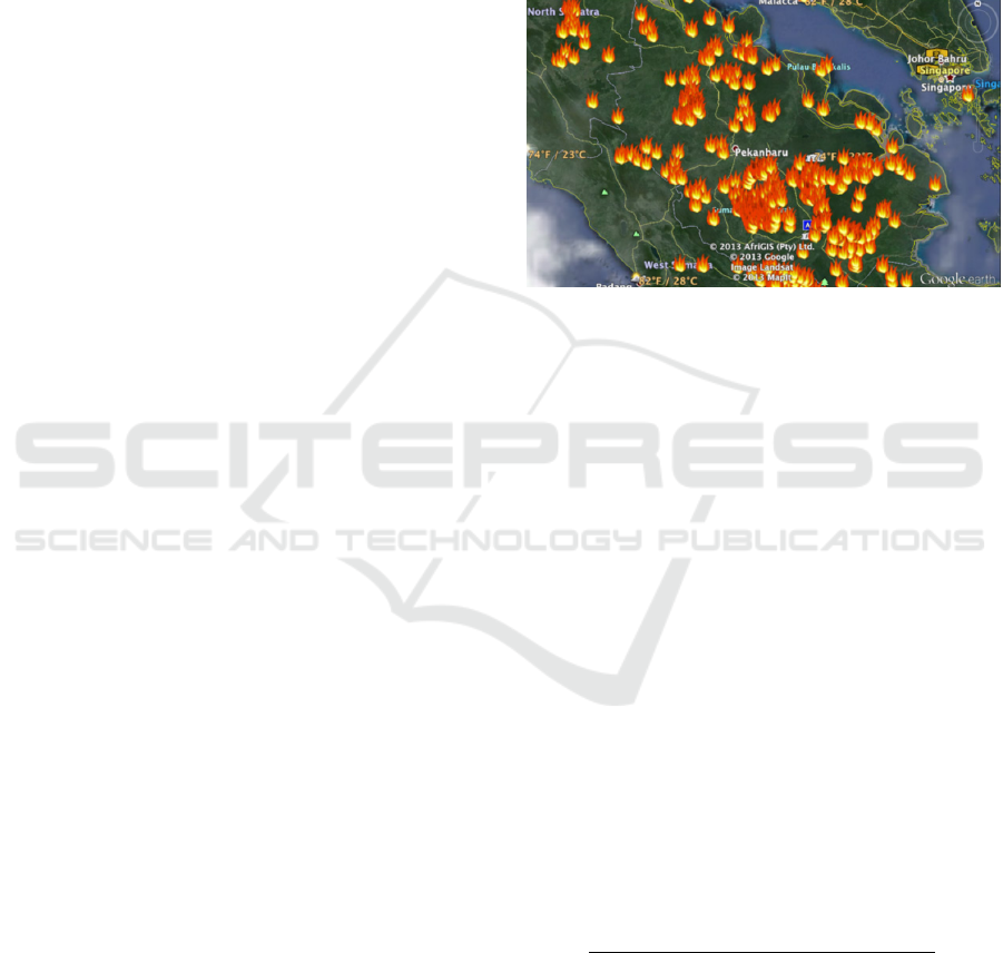
south. Figure 1 shows the number of critical points in
accordance with the distribution plan distributed in all
regions of Riau province.
Figure 1: Number of fire hotspots in Riau Province based
on satellite image.
The access point coverage estimate that a series of
WSNs sensors are installed in a environmental area in
Riau province to monitoring this area. The function
of coverage is P given as:
P = f (x, y, t) = {(x
1
, y
1
), ...(x
n
, y
n
)},
(x
k
, y
k
) = f (t), k = 1, 2, 3, ..., n
(1)
(x, y) is the sensor coordinates in the area of
monitored and t is the time. This model uses 2D
spatial projection from the fire control area, 3D
sphere. In this issue, the networks do not move except
the WSN cellular sensor, but the position of the sensor
depends on time, because the sensor node must stop
working from time to time. There may be different
reasons for completing this process: hardware failure,
accident, battery consumption and accidental sensor
removal, etc.
Assume that you specify the scope of the IP matrix
as a value of scalar that represents of percentage in
coverage area observed in a certain time:
IP =
area covered with sensors
the total area of the surveillance region
100%
(2)
The basic component of model can be write in
WSNs as sensor node for defined a vector:
S = (d, E(t)) (3)
the area covered can write as d by radio signals
that exchange data with neighboring nodes when the
ICoSET 2019 - The Second International Conference on Science, Engineering and Technology
136

sensor is in the transmission range or transmission
range. E (t) is the available energy to power the
sensor. Assume that there is a homogeneous of sensor
network to n integrated type sensors concentrators to
communicate with distribution nodes (Kadir et al.,
2019).
The parameters of network can be described in the
vector as:
M = (n, f
0
, ∆E) (4)
n can be defining as the number of sensor; for
normal transmission frequencies and the consumption
of energy per transmission and transmission. Assume
that the sensor node period sends to the collected of
data to adjacent of nodes. Consumption of energy is
∆E include the spent energy in data collection and
process. In each node has 2 parts:
(a) feel the transmission and environmental data.
(b) receives data from the neighboring and
forwarding nodes.
The function of WSNs sensor center nodes is to
collects data from each of sensor nodes then send
it to the data coordination center or base station.
Data packets received and sent by the coordinator
node, which contains the measurement values and
address (humidity, temperature, and CO
2
) of the
original sensor node. WSN central nodes have
uninterruptible power supplies and communication
channels between the central node and the unlimited
coordination center. Therefore, the simulation regards
the sensor center as ”always available”. Main purpose
of this simulation and measurement is for optimizing
the networks path to send data from the sensors node
to the hub (Aksamovic et al., 2017).
4 DEVELOPMENT WSN NODE
FOR FOREST FIRE
DETECTION
Forest fire is a natural or man-made events in several
cases throughout the global. Fire areas are found
major in climate, then the rainfall is high to provide
a important amount of vegetation, but in summer very
hot and in dry environments can create hazardous
fuel loads. Global of warming will assist to growth
the number of importance of this phenomena. Every
dry season a forest fire is destroyed not only by
thousands of hectares of forest land, but also by public
assets, goods, resources and facilities. In addition,
firefighters and civilians face the risk of facing horrific
victims every year. Figure 2 shows a diagram of a
series of WSNs sensor used in the forest area for the
detection purposes of fire.
Figure 2: The sample of topology in the WSNs sensor nodes
deploy in a forest for disaster detection.
Forest fires are a common and active phenomenon
that can change their nature and behavior from one
place to another and over time. The truth is that in
some places there is limited fuel for forests, so fires
that continue to burn must spread to the nearest fuel.
The achieved by spreading to the complex heating to
neighboring in housing and community obtained from
the complex behavior of the fire. Another case to
approach is based on the WSNs paradigm designed
and developed in a research project involving all key
players in the forest and firefighters for operations.
Figure 3: A WSNs sensor nodes propose use ZigBee
standard.
Another scenario in Figure 3 illustrates the
proposed schematic structure for multi sensors
node, controllers, routers, cluster heads, and remote
servers for the application WSNs based systems
Forest Fire Monitoring System using WSNs Technology
137
for protection management and forest fire detection
and. Decision making This tree topology network
cluster structure proposes a project to reduce energy
loss and data packets during transmission. The
standard of ZigBee technique is a widely standard
based on IEEE 802.15.4, applicable to low-level PAN
(Wireless). ZigBee is one of the wireless network
standards for low-power sensors that is applied at
868/915 MHz and multi-frequency 2.4 GHz. The
technical advantage recommended by ZigBee is that
ZigBee offers a battery system that is durable, small,
and low battery. Cost, automatic or semi-automatic
installation, and high reliability. Therefore, in the
development and of WSNs node design is used by
multisensory systems to get the most appropriate
choice for the detection and monitoring of forest fires
(Kadir, 2017).
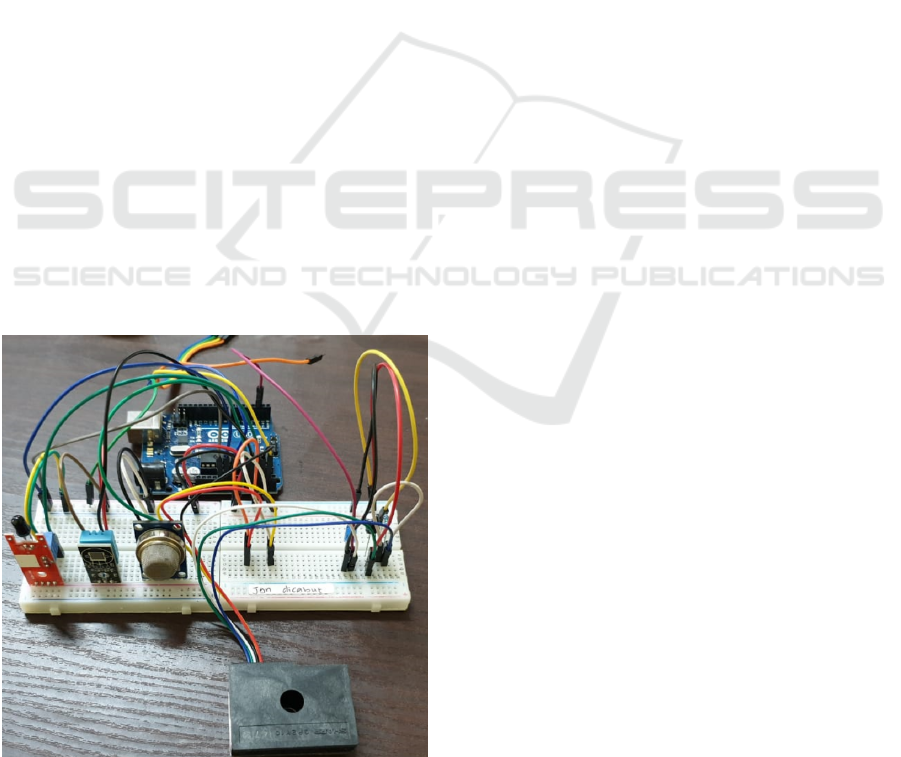
The hardware used to detect and monitor fires
at WSN nodes is available in many kinds on the
market. Where humidity, smoke, temperature, and
carbon sensors are positioned at the node to detect
all parameters that are strongly associated with forest
fires. Figure 4 shows the actual formation of the
sensor in the environmental parameter calibration
test, before the sensor node is positioned in the
field, the sensor node must be configured according
to design and requirements. All nodes send data
or messages to the coordinator WSNs, which has
the function of receiving all information from the
scattered nodes.
Figure 4: A Prototype of WSNs sensor nodes with multiple
sensors use Arduino processor.
5 CONCLUSIONS
It has been proposed to develop a WSN node to detect
fires and monitor from various sensors for correct
detection. Projects that include mathematical analysis
and regional approaches must cover the entire Riau
province. Sensors of humidity, temperature, smoke,
and carbon are the focus of attention in this issue
of these parameters are the main parameter for
fire conditions both on land and in the forest.
Recommended sensor nodes using the low-power
ZigBee model, sensor nodes can be used as long
battery-powered nodes. At least in each region,
a network coordinator must be formed to cover
the entire Riau province and the gateway must be
available to hospital the server (cloud database) and
monitor the computer. The highly applicable WSN
concept proposed to detect forest of fires in province
of Riau is very useful for preparing presentations.
ACKNOWLEDGEMENTS
Authors would like to say thank you very much
to KEMENRISTEKDIKTI Indonesia and Universiti
Teknologi Petronas, Malaysia for funding this
research as well as Universitas Islam Riau to support
the facilities.
REFERENCES
Aksamovic, A., Hebibovic, M., and Boskovic, D. (2017).
Forest fire early detection system design utilising
the wsn simulator. In 2017 XXVI International
Conference on Information, Communication and
Automation Technologies (ICAT), pages 1–5. IEEE.
Aranzazu-Suescun, C. and Cardei, M. (2017). Distributed
algorithms for event reporting in mobile-sink wsns for
internet of things. Tsinghua Science and Technology,
22(4):413–426.
Illiano, V. P. and Lupu, E. C. (2015). Detecting malicious
data injections in event detection wireless sensor
networks. IEEE Transactions on Network and service
management, 12(3):496–510.
Kadir, E. A. (2017). A reconfigurable mimo antenna
system for wireless communications. In 2017 4th
International Conference on Electrical Engineering,
Computer Science and Informatics (EECSI), pages
1–4. IEEE.
Kadir, E. A., Irie, H., Rahim, S. K. A., Arta, Y.,
and Rosa, S. L. (2018a). Reconfigurable mimo
antenna for wireless communication based on arduino
microcontroller. In 2018 IEEE International RF and
Microwave Conference (RFM), pages 119–122. IEEE.
ICoSET 2019 - The Second International Conference on Science, Engineering and Technology
138

Kadir, E. A., Irie, H., and Rosa, S. L. (2019). Modeling
of wireless sensor networks for detection land and
forest fire hotspot. In 2019 International Conference
on Electronics, Information, and Communication
(ICEIC), pages 1–5. IEEE.
Kadir, E. A., Rosa, S. L., and Gunawan, H. (2016).
Application of rfid technology and e-seal in container
terminal process. In 2016 4th International
Conference on Information and Communication
Technology (ICoICT), pages 1–6. IEEE.
Kadir, E. A., Rosa, S. L., and Yulianti, A. (2018b).
Application of wsns for detection land and forest fire
in riau province indonesia. In 2018 International
Conference on Electrical Engineering and Computer
Science (ICECOS), pages 25–28. IEEE.
Kansal, A., Singh, Y., Kumar, N., and Mohindru, V. (2015).
Detection of forest fires using machine learning
technique: A perspective. In 2015 Third International
Conference on Image Information Processing (ICIIP),
pages 241–245. IEEE.
Liu, Y., Liu, Y., Xu, H., and Teo, K. L. (2018). Forest fire
monitoring, detection and decision making systems
by wireless sensor network. In 2018 Chinese Control
And Decision Conference (CCDC), pages 5482–5486.
IEEE.
Pant, D., Verma, S., and Dhuliya, P. (2017). A study
on disaster detection and management using wsn
in himalayan region of uttarakhand. In 2017 3rd
International conference on advances in computing,
communication & automation (ICACCA)(Fall), pages
1–6. IEEE.
Sasirekha, S. and Swamynathan, S. (2017). Cluster-chain
mobile agent routing algorithm for efficient data
aggregation in wireless sensor network. Journal of
Communications and Networks, 19(4):392–401.
Yulianti, N., Hayasaka, H., and Usup, A. (2012). Recent
forest and peat fire trends in indonesia the latest
decade by modis hotspot data. Global environmental
research, 16(1):105–116.
Forest Fire Monitoring System using WSNs Technology
139
