
A Domain Specific Language for Web-based GIS
Suilen H. Alvarado, Alejandro Corti
˜
nas, Miguel R. Luaces, Oscar Pedreira and Angeles S. Places
Universidade da Coru
˜
na, Centro de Investigaci
´
on CITIC, Laboratorio de Bases de Datos,
Facultade de Inform
´
atica, Campus de Elvi
˜
na s/n, 15071, A Coru
˜
na, Spain
Keywords:
Model-driven Engineering, Domain Specific Language, Geographic Information Systems.
Abstract:
Geographic information systems (GIS) manage entities with a spatial component (typically, in the form of
a point, line, or polygon defined according to a known geographic coordinate system), and provide specific
operations to process them, and specific interfaces to visualize them. Although different GIS may provide a
completely different set of functionalities, they all share a common set of concepts, architecture, and tech-
nologies. Therefore, in the development of GIS there are typically large parts of the system that can be very
repetitive. In this paper, we present a domain-specific language to develop GIS from high-level declarative
specifications. We present a metamodel for web-based GIS, and a domain-specific language based on that
metamodel. We also present a usage example that shows how the language would be used in a real scenario.
1 INTRODUCTION
Geographic Information Systems (GIS) allow to col-
lect, integrate, query, analyze, and represent data re-
garding geospatial information (Worboys and Duck-
ham, 2004; Longley et al., 2015). The data man-
aged in a GIS typically represent real-world entities
with a geospatial component, such as points of in-
terest, roads, trajectories, or electrical networks, for
example. In general, GIS are developed focusing
on solving planning and management problems that
cover several areas of application. Some fields in
which using a GIS solution seems mandatory nowa-
days are, for example, transportation management,
environmental management, territorial planning, lo-
gistics, infrastructures, or security. Moreover, the rise
of mobile technologies and devices with affordable
geolocalization capabilities has broadened the range
of applications of GIS, and also the volumes of data
they manage.
Independently of the specific purpose and appli-
cation domain of each GIS, these systems share a
set of common components and features such as dig-
itizing geographic data, showing geospatial data in
map viewers, common tools related to maps, route
optimization, etc. Currently, GIS are developed us-
ing technologies, tools, and libraries that facilitate
the storage and processing of geospatial information.
However, they are typically developed by implement-
ing the system “from scratch”, or reusing basic com-
ponents. In the last years, the standards from the Open
Geospatial Consortium (OGC)
1
, and the general rise
of web applications have driven the evolution from
desktop-based to web-based GIS, which are nowa-
days the most common solution. Given the similarity,
and the number of elements shared between different
GIS, we believe that model-driven development tech-
niques can be applied in this domain.
Model-driven engineering (MDE) aims at using
system models as active artifacts in the development,
successively transforming them into models at a lower
level of abstraction and, finally, into the source code
of the system (Pastor and Molina, 2007; Brambilla
et al., 2017). In this way, the effort required to de-
velop the system (or a part of it) is smaller, and the
code generated automatically from high-level models
of the system is less likely to present errors. The first
step in MDE is to develop a metamodel of the domain,
which defines a domain-specific modeling notation.
The metamodel can also be used to define a domain-
specific language (DSL), that allows specifying the
system in a language at a higher-level of abstraction
than that of general-purpose programming languages,
with a significantly smaller development effort.
In this paper, we explore the application of MDE
techniques to the development of web-based GIS, and
we propose a DSL for GIS development. As we will
see in Section 3, it is a high-level declarative language
that allows the developer to define, at a high level of
abstraction, the elements that will be managed in the
1
OGC: http://www.opengeospatial.org/
462
Alvarado, S., Cortiñas, A., Luaces, M., Pedreira, O. and Places, A.
A Domain Specific Language for Web-based GIS.
DOI: 10.5220/0008559104620469
In Proceedings of the 15th International Conference on Web Information Systems and Technologies (WEBIST 2019), pages 462-469
ISBN: 978-989-758-386-5
Copyright
c
2019 by SCITEPRESS – Science and Technology Publications, Lda. All rights reserved

GIS, and how they are going to be visualized.
The rest of the article is structured as follows: In
Section 2 we present background and related work. In
Section 3 we describe the main concepts, elements,
and characteristics of GIS, and we present a meta-
model for web-based GIS and a DSL that allows au-
tomating the development of this type of applications.
In Section 4 we present a case of use of the DSL
where we specify a real application. Finally, Section 5
presents the conclusions of the paper and lines for fu-
ture work.
2 BACKGROUND AND RELATED
WORK
The rapid evolution of new technologies, the increas-
ing complexity of software, and the demand to sat-
isfy a greater number of requirements are some of the
motivations of paradigms that aim at automating the
software development process. Model-driven engi-
neering (MDE) is a software development approach
that promotes the use of models as active artifacts in
all stages of software development. In MDE, high-
level models are automatically transformed into mod-
els at a lower level of abstraction, and finally, into
the source code (or part of) the system. The goal of
this paradigm is to produce software following an ap-
proach similar to that of other traditional industries.
One of the approaches within MDE is model-driven
development (MDD) (Brambilla et al., 2017), which
defines models as the main artifact for modeling soft-
ware systems at a level of abstraction higher than the
allowed by programming languages. The objective of
this approach is to increase the level of automation,
improve aspects of quality, productivity and reduce
the costs associated with the processes of evolution
and maintenance (Pons et al., 2010).
A standard defined by the Object Management
Group (OMG)
2
on its particular vision of MDD
is the model-driven architecture (MDA)
3
(Pastor
and Molina, 2007), structured in four layers: CIM
(computational independent models), PIM (platform-
independent models), PSM (platform-specific mod-
els), and ISM (implementation-specific model).
These models can be defined using general-purpose
modeling languages, such as UML, or domain-
specific languages (DSL), designed to be used in par-
ticular application domains.
A DSL is a language designed for software devel-
opment in a specific application domain. The differ-
2
OMG: http://www.omg.org
3
MDA: http://www.omg.org/mda
ence between a DSL and a general-purpose program-
ming language is that a DSL allows us to work di-
rectly with domain-specific concepts and constructs,
which leads to a greater expressiveness (Mernik et al.,
2005; Fowler, 2010). Although implementing a DSL
can require a significant effort, their main benefit is
that they allow us to specify/implement a system with
significantly less effort.
A wide variety of DSLs have been developed
in different application domains. For example, in
software engineering, there has been proposed a
DSL to support the process of generating source
code for desktop-based database application using
the Java language (Lolong and Kistijantoro, 2011),
another DSL to model performance tests for web
applications (Bernardino et al., 2016), or even to
specify textual use cases and, from them, generate
semi-automatically use case, class and sequence di-
agrams (Miranda et al., 2017). Within the area of in-
ternet of things (IoT), a visual domain-specific mod-
eling language (VDSML) was defined to abstract IoT
application designers from some complexities that
present this type of application, like the wide range
of hardware and software entities, or the middle-ware
specific features (Salihbegovic et al., 2015). Also
in this field, another DSL was proposed to model
a smart city system based on specific domain con-
cepts (Rosique et al., 2017). Finally, in mobile ap-
plication development, there are DSLs to implement
systems for multiple platforms (Kramer et al., 2010;
Ribeiro and da Silva, 2014), or to describe the struc-
ture and behavior of real-time mobile applications
centered on data (Behrens, 2010).
The systematic mapping presented in (Kosar et al.,
2016) highlights some lines of DSL research that may
be further studied. For example, this mapping re-
vealed that most of the articles are focused on the de-
sign and implementation of DSLs, but few of them
considered aspects such as validation and usability
evaluation, domain analysis, or maintenance.
In previous works (Corti
˜
nas et al., 2017b; Corti
˜
nas
et al., 2017a), we explored the automated develop-
ment of GIS through a combination of software prod-
uct line (SPL) technologies and basic MDE tech-
niques applied to the generation of the database and
data model. Our platform allowed the user to define
the data model of the system, and to specify a selec-
tion of optional features that could be included in the
final system. In this paper we further explore the ap-
plication of MDE techniques for the development of
web-based GIS through the definition of a DSL that
considers the definition of the domain geospatial enti-
ties, and also how they will be visualized in the web.
A Domain Specific Language for Web-based GIS
463

3 A DOMAIN SPECIFIC
LANGUAGE FOR WEB GIS
The first GIS applications were developed for desk-
top environments. At that time, the capabilities of
web technologies were very limited, and the require-
ments of a GIS were too complex for web environ-
ments, so desktop was the only choice. However, the
improvements in web technologies and the computa-
tional power of current devices (server, desktop, and
mobile) have made it possible to develop web-based
GIS. Although some GIS applications are still devel-
oped for desktop environments, the web has become
the preferred choice. The ISO and the Open Geospa-
tial Consortium (OGC) have defined a set of evolving
standards which define most of the aspects for GIS
domain, including models, procedures, services, and
architectures. We can also see the focus on the web
in these standards since many network-based services
were defined, such as the web map service
4
(WMS)
or the web feature service
5
(WFS).
In this section, we present a DSL for web-based
GIS. The main characteristics of the DSL are (i) it
allows the developer to specify the entities to be man-
aged in the GIS, and how they will be visualized in
the web through layers and maps, (ii) it is a declar-
ative language, that is, using this DSL the developer
just specifies the data model of the system and how
the data will be shown, without having to implement
any details related to these features. In sub-section
3.1 we briefly present the architecture of a GIS and
a metamodel of this domain. In sub-section 3.2 we
present the DSL.
3.1 GIS Architecture and Main
Constructs
The main difference between a regular information
system and a GIS is the support of geospatial data
types. That is, the data model of a GIS can include
properties such as Point, Line, or Polygon. A Point is
defined by a latitude and longitude, and represents a
particular position in the space. It is used to locate any
objects in the space, such as traffic lights. A Line is a
set of joined Points, and it is common using it to rep-
resent roads or pipes. Polygons are used to represent
areas, such as administrative divisions of the territory.
There is also a data type that can represent any kind
of geometry, called Geometry, which is also in fact a
superclass of all the rest.
4
OpenGIS Web Map Server Implementation Specifica-
tion: http://www.opengeospatial.org/standards/wms
5
OpenGIS Web Feature Service 2.0 Interface Standard:
http://www.opengeospatial.org/standards/wfs
Due to the nature of these data types, there are
specific operations we can execute on them. For ex-
ample, we can check if two geometries intersect by
using the spatial predicate st intersects, or we can
calculate the area of a Polygon by using the operation
st area. Similarly, we can create a new polygon by
joining two existing polygons.
An important characteristic of the spatial data
types is that they need to be defined within a spatial
reference system (SRS). A SRS defines the map pro-
jection used by some spatial data or by a map viewer.
Setting a specific SRS is required since there is not
only one way to make the transformation between
some coordinates and the actual position of an object.
Depending on the spatial context for which a GIS is
built, we may prefer to use one SRS or another. For
example, if our product needs to handle data from all
around the world, we need to use a global SRS such as
WGS84, identified by the SRID 4326; but if we need
to implement a product handling data from a smaller
territory and in a very precise way, we would prob-
ably use a local SRS, such as the ETRS89 or UTM
zone 29N, identified by the SRID 25829. The SRS
are defined in the standard ISO 19111:2007
6
.
Supporting geographic data types and spatial op-
erations is done by using a specific set of tools and
technologies that comply with the GIS standards. In
this way, we have extensions for relational databases
that handle GIS related features such as PostGIS
7
,
an extension for PostgreSQL, or Oracle Spatial
8
. If
we want to handle these features in a higher-level
language, like Java, we have tools such as the Java
Topology Suite (JST) or the whole library collection
Java GeoTools. The same operations can be run on
JavaScript by using GeoJSON and libraries such as
Turf. Finally, the view layer is built with the help of
tools such as OpenLayers or Leaflet.
The visualization of geospatial data involves three
concepts: layers, styles, and maps. A layer is an im-
age that can be geographically bounded. This image
can be composed by a set of real photos, such as in
the case of a satellite view of the world, or it can
be generated from some geographic data by apply-
ing a given style. When a layer is loaded in a map
viewer, the viewer is responsible for asking the con-
crete image needed depending on the actual bounds
of the view, using a specification such as TileLayer
or WMS. There are cases where the image is gener-
ated by the map viewer itself when we are dealing
6
ISO: Geographic information: Spatial referencing by
coordinates: https://www.iso.org/standard/41126.html
7
PostGIS: https://postgis.net/
8
Oracle Spatial: https://www.oracle.com/database/
technologies/spatialandgraph.html
APMDWE 2019 - 4th International Special Session on Advanced practices in Model-Driven Web Engineering
464
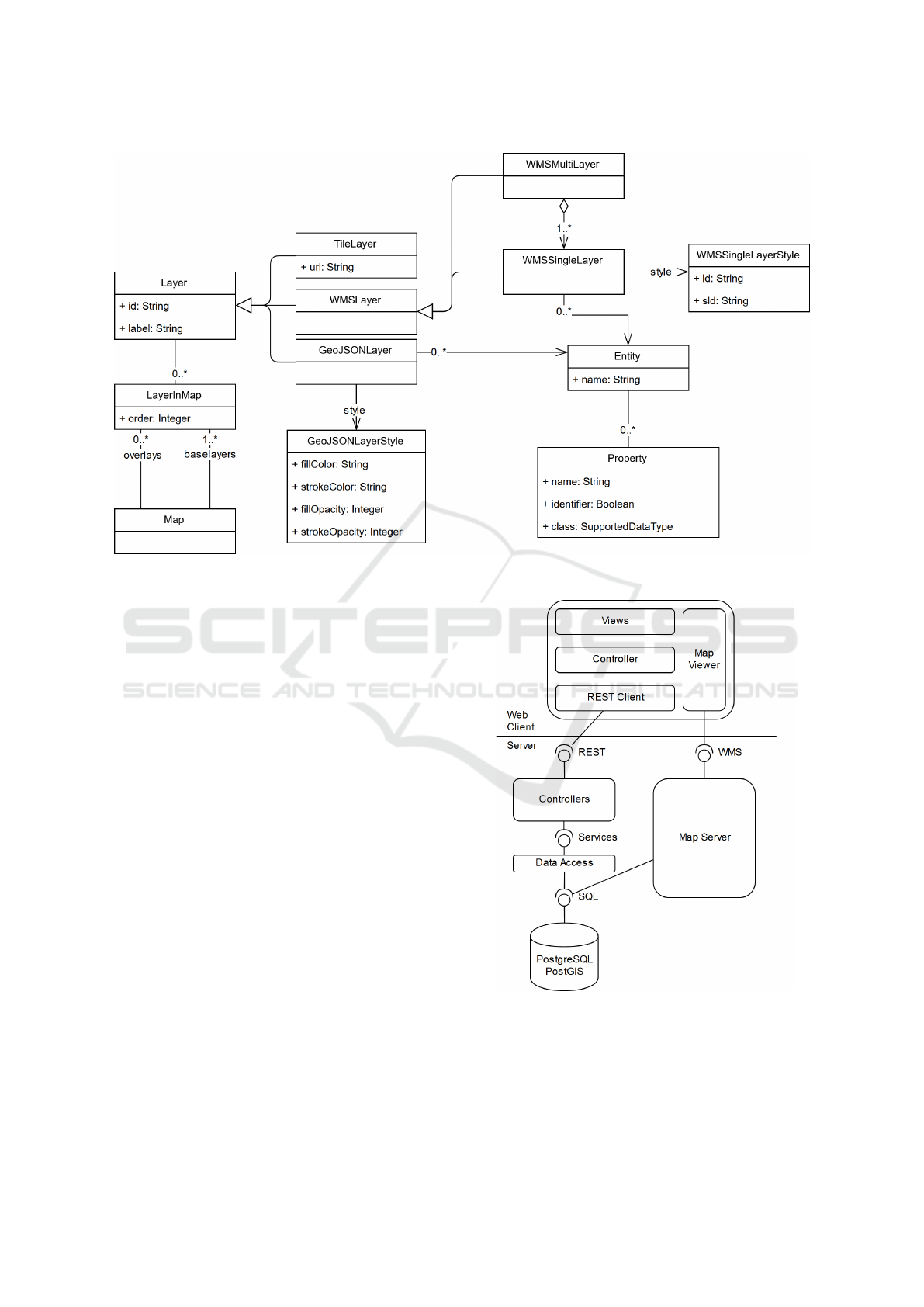
Figure 1: A metamodel of web-based GIS (reduced version).
with raw data loaded with GeoJSON documents. The
styles determine how the data behind a layer is trans-
formed into real images. Depending on the type of
layer, we have different style specifications. For ex-
ample, styles are not necessary for satellite images.
If we are handling a WMS layer we need to use a
style layer descriptor (SLD). A map is composed of a
set of layers with their styles, rendered in a particular
order. Usually the layers are generated from data of
the application itself, this is, from entities which have
a geographic property that represents their position.
For example, we can have a layer of the traffic lights
of a city, or a layer that shows the roads of a region.
The metamodel presented in Figure 1 formalizes these
concepts and how they relate to each other.
Figure 2 shows our architecture for a web-based
GIS. The server side provides two services for the
clients: a REST service handles most of the alphanu-
meric data and can provide geographic data in a seri-
alizable format (such as GeoJSON), and a WMS that
provides cartography images by using a map server.
Both the data and cartography services are fed from
the same database. In the client side, the data layer is
the component in charge of handling the REST com-
munication, the logic of the application is handled by
JavaScript code, and the templates are created using
HTML. There is also a map viewer library that is
working as a closed component and that can handle
direct communication with the WMS.
Figure 2: Typical architecture of a web-based GIS.
3.2 A DSL for GIS
In this section, we present and describe an excerpt
of the declarative DSL we have designed for defining
and generating web-based GIS.
A Domain Specific Language for Web-based GIS
465

The specification of a new application starts with
the sentence CREATE GIS. In this sentence, we spec-
ify the name of the project, and the spatial reference
system we will use (each reference system is defined
by a specific id, srid). The DSL is thought to be used
in an interactive terminal. The USE GIS sentence al-
lows us to change from one project to another (see
Listing 1).
CREATE GIS name USING srid;
USE GIS name;
Listing 1: CREATE and USE sentences.
The data model can be specified using the CREATE
ENTITY sentence (see Listing 2). Each entity has
a name and a set of properties. A property is
defined also by a name and a data type. The
type can be a boolean (BOOLEAN), a numeric type
(INTEGER, LONG, FLOAT or DOUBLE), a alphanumeric
type (STRING or TEXT), a temporal type (DATETIME
or DATE), or any of the geographic types (GEOMETRY,
POINT, MULTIPOINT, LINE, MULTILINE, POLYGON or
MULTIPOLYGON). Each entity must have an identifier,
defined by adding the keyword IDENTIFIER to the
properties it is composed of. Relationships between
entities can be defined as well, indicating the name of
the relationship, its cardinally and whether it is bidi-
rectional or just navigable in one of the directions.
CREATE ENTITY entityName (
propertyName1 dataType1 [ IDENTIFIER ] [ REQUIRED ],
propertyName2 dataType2 [ IDENTIFIER ] [ REQUIRED ],
...
relationshipName1 entityName RELATIONSHIP{ (
{ 0..1 | 1..1 | 0..* | 1..* },
{ 0..1 | 1..1 | 0..* | 1..* }
) [ BIDIRECTIONAL ] | MAPPED_BY
relationshipNameInTheOtherEntity },
...
);
Listing 2: CREATE ENTITY sentence.
Once the data model of the system has been de-
fined, we can define the different layers available to
be visualized in the map viewers of the application
(see Listing 3). The CREATE LAYER sentence allows
us to create three different types of layers: Tile Lay-
ers, WMS Layers and GeoJSON Layers. Tile layers
are defined by an external URL, and they are used
normally as base layers. GeoJSON layers are gener-
ated from an entity of the application, which is loaded
into the map from the REST service applying a cer-
tain style. Entities loaded using this kind of layers can
be editable using the forms of the application. Finally,
WMS layers are loaded as cartography through a map
server, and they can be generated from one or several
entities from the application.
CREATE TILE LAYER name [ AS label ] (
url STRING
);
CREATE GEOJSON LAYER name [ AS label ] (
entity [ EDITABLE ],
fillColor HEX,
strokeColor HEX,
fillOpacity FLOAT,
strokeOpacity FLOAT
);
CREATE WMS_STYLE name (
styleLayerDescriptor FILE_NAME
);
CREATE WMS LAYER name [ AS label ] (
entity1 WMS_STYLE,
entity2 WMS_STYLE,
...
);
Listing 3: CREATE LAYER sentence.
Finally, the sentence CREATE MAP (see Listing 4)
allows us to define the map viewers of the application.
Each map viewer has a set of layers, usually at least
of them works as base layers, and then there is a set of
overlays. Some of the layers can be hidden by default.
CREATE [ SORTABLE ] MAP name [ AS label ] (
layer1 [ IS_BASE_LAYER ] [ HIDDEN ],
layer2 [ IS_BASE_LAYER ] [ HIDDEN ],
...
);
Listing 4: CREATE MAP sentence.
Finally, the sentence GENERATE GIS would trans-
form all the specifications made with previous sen-
tences into the source code of a working system. The
resulting GIS would provide the users with forms and
listings to create, edit, list, and remove any of the enti-
ties defined in the data model. The map viewer would
also include all the layers, styles, and maps defined.
The resulting system may be missing complex func-
tionalities required by the users. It must be noticed
that the purpose of the DSL is not to generate a com-
plete system with arbitrarily complex functionalities,
but to generate a functional system that can be ex-
tended with more complex functions implemented in
the general-purpose programming language.
GENERATE GIS name;
Listing 5: GENERATE GIS sentence.
CREATE GIS local_administration_manager USING 25829;
USE GIS local_administration_manager;
CREATE ENTITY Municipality (
id Long IDENTIFIER,
name String REQUIRED,
extension MultiPolygon,
APMDWE 2019 - 4th International Special Session on Advanced practices in Model-Driven Web Engineering
466
roads Road RELATIONSHIP(1..1, 0..*),
offices AdministrativeOffice RELATIONSHIP(1..1, 0..*)
BIDIRECTIONAL
);
CREATE ENTITY Road (
id Long IDENTIFIER,
status String,
path MultiLine
);
CREATE ENTITY AdministrativeOffice (
id Long IDENTIFIER,
status String,
location Point,
municipality Municipality RELATIONSHIP MAPPED_BY offices
);
CREATE TILE LAYER base AS "Base Layer" (
url "https://{s}.tile.openstreetmap.org/{z}/{x}/{y}.png"
);
CREATE GEOJSON LAYER offices AS "Administrative Offices" (
AdministrativeOffice EDITABLE,
fillColor #243452,
strokeColor #eeeee3,
fillOpacity 0.8,
strokeOpacity 0.9
);
CREATE BasePolygonStyle name (
styleLayerDescriptor
"/home/user/sld/file_polygon_sld.xml"
);
CREATE BaseLineStyle name (
styleLayerDescriptor "/home/user/sld/file_line_sld.xml"
);
CREATE WMS LAYER defaultOverlay AS "Overlay" (
Municipality BasePolygonStyle,
Road BaseLineStyle
);
CREATE SORTABLE MAP map AS "Map Viewer" (
base IS_BASE_LAYER,
defaultOverlay,
offices HIDDEN
);
GENERATE GIS local_administration_manager;
Listing 6: Example of application defined by the DSL.
4 USE EXAMPLE
In this section, we present an example of use of our
DSL. First we describe an intentionally simplified
GIS application. Then we show how we specify this
application using our DSL.
Local administrations usually need to manage a
set of buildings related with many different areas,
such as water distribution buildings (pipes, wells,
tanks, chlorination stations, etc.), road networks
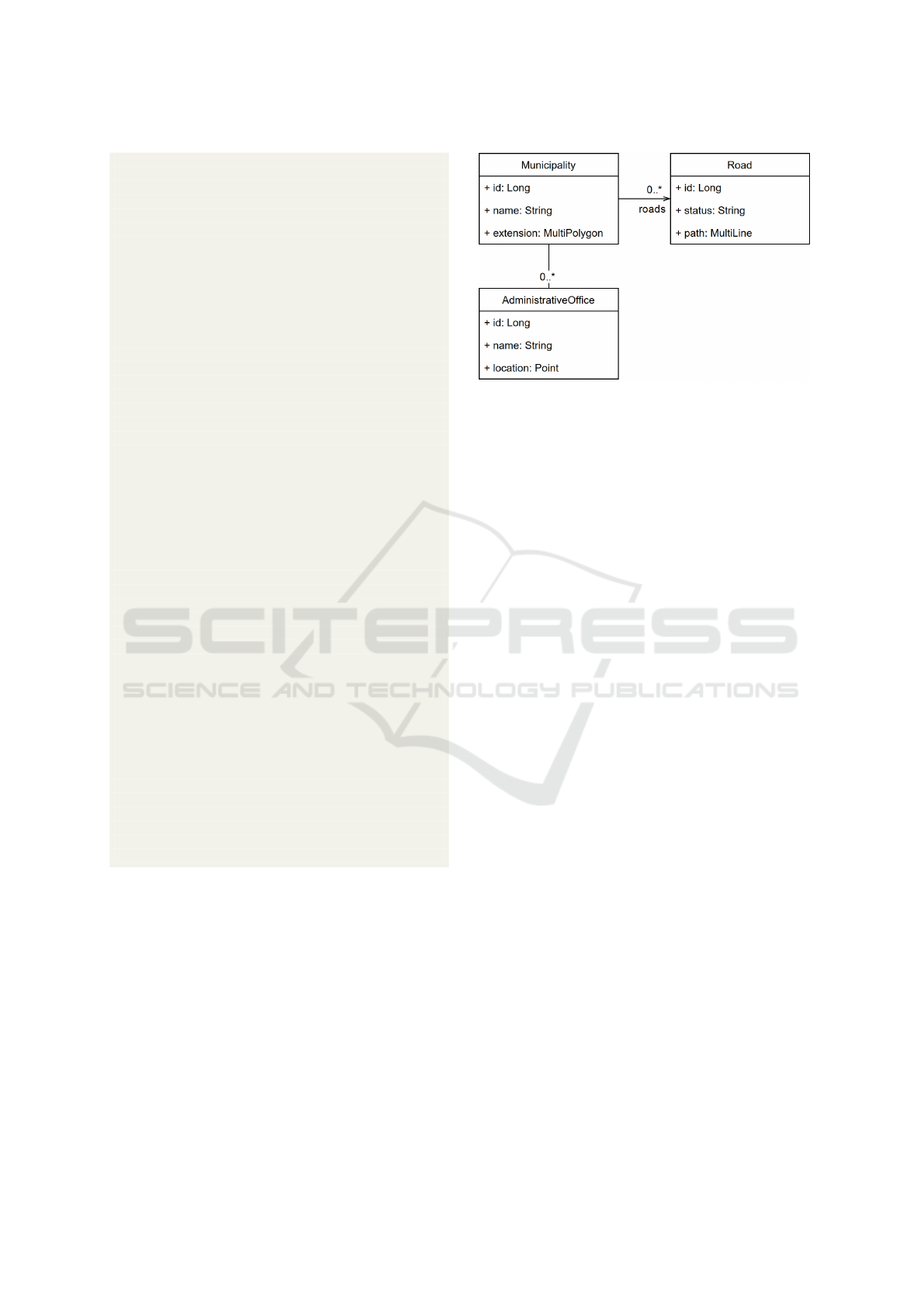
Figure 3: Data model of the example application.
(streets, municipal roads, bridges, etc.), cultural-
related buildings (schools, sport halls, community
centres, etc.), or administrative related buildings. For
a long time now, most of the applications managing
this kind of data are based on GIS technologies, al-
lowing the users to visualize the information through
map viewers and to digitize new elements.
Using our DSL, we could define such application.
Figure 3 shows a simplified data model that specifies
that we manage municipalities, roads, and administra-
tive offices, each one with its geographic component
(a multi-polygon for municipalities, a multi-line for
roads, and a point for administrative offices) and with
their relationships. Listing 6 shows the DSL code that
specifies the web-based GIS application that manages
that data model. First, the new application is created.
We use the SRID 25829, which is a local reference
system commonly used when working in the north-
west of Spain.
Next, we define the data model, creating its three
entities. The names of the entities will be used after-
ward for defining the different layers that will be pro-
vided by the application. These layers are also linked
to the only map viewer we define, in which it will ap-
pear a TileLayer from Open Street Maps (OSM) that
works as the base layer, a WMS Layer that combines
both the municipalities and the roads, and a GeoJSON
Layer with the administration offices. The latter also
allows accessing a form directly from the map viewer
so the offices can be edited.
Finally, the GIS application could be generated, to
produce a software with forms, listings, and maps to
manage the entities, layers, and the map we defined.
A Domain Specific Language for Web-based GIS
467

5 CONCLUSIONS AND FUTURE
WORK
GIS is a domain in which most assets are shared
among many products, such as features or capabili-
ties, technology, libraries, etc., and the main differ-
ence between different applications are changes in the
data model. Therefore, it is a suitable domain to apply
MDE to facilitate the early stages of development.
In this paper, we have proposed a high-level
declarative DSL for GIS specification and develop-
ment. This language allows the developer to define
the different elements that will be managed in the ap-
plication, and how they are going to be visualized: we
can define the entities of the data model, their prop-
erties (including spatial data types), and the relation-
ships between them, different types of layers (Tile,
WMS, and GeoJSON layers), and maps that will show
the data according to the definition of the entities, the
layers, and their corresponding styles.
The purpose of the proposed DSL is to allow the
developers to automatically generate a GIS applica-
tion that will include forms, listings, and maps to
manage the defined entities and to visualize them ac-
cording to the specification. In most cases, a real sys-
tem will surely include complex functionalities that
cannot be specified with our language. We consider
that those arbitrarily complex functions are out of the
scope of our language since the best way of imple-
menting them will be, in most cases, to do that di-
rectly in the final project. That is, while our language
may not be able to generate a complete GIS for any
application, it allows the developer to generate a base
system with all the functionalities that can be gener-
ated automatically.
Future work includes implementing the interpreter
and code generator corresponding to our language and
validating its use through experiments in which we try
to generate existing applications.
ACKNOWLEDGEMENTS
Partially funded by: Xunta de Galicia/FEDER-UE
CSI: ED431G/01 (Centros singulares de inves-
tigaci
´
on Galicia); Xunta de Galicia/FEDER-UE
CSI: ED431C 2017/58 (Grupo de Referencia
Competitiva); Xunta de Galicia / FEDER-UE,
ConectaPeme, GEMA: IN852A 2018/14; MINECO-
AEI/FEDER-UE Datos 4.0 (TIN2016-78011-c4-1-
R); MINECO-AEI/FEDER-UE ETOME-RDF3D3
(TIN2015-69951-R); MINECO-AEI/FEDER Flatcity
(TIN2016-77158-C4-3-R); MICINN-AEI/FEDER-
UE BIZDEVOPS: (RTI2018-098309-B-C32).
REFERENCES
Behrens, H. (2010). Mdsd for the iphone: developing a
domain-specific language and ide tooling to produce
real world applications for mobile devices. In Pro-
ceedings of the ACM international conference com-
panion on Object oriented programming systems lan-
guages and applications companion, pages 123–128.
ACM.
Bernardino, M., Zorzo, A. F., and Rodrigues, E. M. (2016).
Canopus: A domain-specific language for modeling
performance testing. In 2016 IEEE International Con-
ference on Software Testing, Verification and Valida-
tion (ICST), pages 157–167. IEEE.
Brambilla, M., Cabot, J., and Wimmer, M. (2017). Model-
driven software engineering in practice. Synthesis
Lectures on Software Engineering, 1(1):1–182.
Corti
˜
nas, A., Luaces, M. R., Pedreira, O., and Places,
´
A. S.
(2017a). Scaffolding and in-browser generation of
web-based gis applications in a spl tool. In Pro-
ceedings of the 21st International Systems and Soft-
ware Product Line Conference-Volume B, pages 46–
49. ACM.
Corti
˜
nas, A., Luaces, M. R., Pedreira, O., Places,
´
A. S.,
and P
´
erez, J. (2017b). Web-based geographic infor-
mation systems sple: Domain analysis and experience
report. In Proceedings of the 21st International Sys-
tems and Software Product Line Conference-Volume
A, pages 190–194. ACM.
Fowler, M. (2010). Domain-specific languages. Pearson
Education.
Kosar, T., Bohra, S., and Mernik, M. (2016). Domain-
specific languages: A systematic mapping study. In-
formation and Software Technology, 71:77–91.
Kramer, D., Clark, T., and Oussena, S. (2010). Mobdsl:
A domain specific language for multiple mobile plat-
form deployment. In 2010 IEEE International Confer-
ence on Networked Embedded Systems for Enterprise
Applications, pages 1–7. IEEE.
Lolong, S. and Kistijantoro, A. I. (2011). Domain spe-
cific language (dsl) development for desktop-based
database application generator. In Proceedings of
the 2011 International Conference on Electrical En-
gineering and Informatics, pages 1–6. IEEE.
Longley, P. A., Goodchild, M. F., Maguire, D. J., and Rhind,
D. W. (2015). Geographic information science and
systems. John Wiley & Sons.
Mernik, M., Heering, J., and Sloane, A. M. (2005). When
and how to develop domain-specific languages. ACM
computing surveys (CSUR), 37(4):316–344.
Miranda, M. A., Ribeiro, M. G., Marques-Neto, H. T., and
Song, M. A. J. (2017). Domain-specific language for
automatic generation of uml models. IET Software,
12(2):129–135.
Pastor, O. and Molina, J. C. (2007). Model-driven architec-
ture in practice: a software production environment
based on conceptual modeling. Springer Science &
Business Media.
Pons, C. F., Giandini, R. S., and P
´
erez, G. A. (2010). De-
sarrollo de software dirigido por modelos.
APMDWE 2019 - 4th International Special Session on Advanced practices in Model-Driven Web Engineering
468

Ribeiro, A. and da Silva, A. R. (2014). Xis-mobile: A
dsl for mobile applications. In Proceedings of the
29th Annual ACM Symposium on Applied Computing,
pages 1316–1323. ACM.
Rosique, F., Losilla, F., and Pastor, J.
´
A. (2017). A do-
main specific language for smart cities. In Multidisci-
plinary Digital Publishing Institute Proceedings, vol-
ume 2, page 148.
Salihbegovic, A., Eterovic, T., Kaljic, E., and Ribic, S.
(2015). Design of a domain specific language and ide
for internet of things applications. In 2015 38th In-
ternational Convention on Information and Commu-
nication Technology, Electronics and Microelectron-
ics (MIPRO), pages 996–1001. IEEE.
Worboys, M. F. and Duckham, M. (2004). GIS: a computing
perspective. CRC press.
A Domain Specific Language for Web-based GIS
469
