
Where Am I: Localization and 3D Maps for Autonomous Vehicles
Farzeen Munir, Shoaib Azam, Ahmad Muqeem Sheri, YeongMin Ko and Moongu Jeon
School of Electrical Engineering and Computer Science,
Gwangju Institute of Science and Technology, Republic of Korea
Keywords:
Localization, 3D Point Cloud, Maps, NDT Matching, Autonomous Vehicles.
Abstract:
The nuts and bolts of autonomous driving find its root in devising the localization strategy. Lidar as one of the
newest technologies developed in the recent years, provides rich information about the environment in the form
of point cloud data which can be used for localization. In this paper, we discuss a localization approach which
generates a 3D map from Lidar’s point cloud data using Normal Distribution Transform (NDT) mapping. We
use our own dataset collected using our self driving car KIA Soul EV equipped with Lidar and cameras. Once
the 3D map has been generated, we have used NDT matching for localizing the self driving car.
1 INTRODUCTION
Autonomous driving is one of the hot research top-
ics captivating the focus of most leading companies
and researchers, and also is a comprehensive research
venture involving interdisciplinary study. The four
fundamental research questions in autonomous driv-
ing are: where am I? What are around me? What will
happen next? and what should I do?. The quest to
find the solution of each one of them is a step towards
successful autonomous driving.
The first and most fundamental question “where
am I? ” signifies the importance of localization and
mapping for autonomous driving (Jo et al., 2015). For
the car to drive without human intervention, it needs
to locate itself in the 3D environment so that it could
navigate. Autonomous vehicles need to come a long
way to have the capability to make real-time deci-
sions. In order to achieve it, mapping and localiza-
tion become critical components of autonomous driv-
ing (Karlsson and Gustafsson, 2017).
Humans require only simple 2D map for navi-
gation. This 2D map information is not enough for
autonomous vehicles to navigate in the environment.
This hindrance of not enough information is com-
pensated with the availability of high definition 3D
maps that include information about road boundaries,
lanes, building, curb height. Besides that, this infor-
mation of environment needs to be precise and accu-
rate. The autonomous vehicles are equipped with Li-
dar and camera sensors that provide the information
about the surroundings. Lidar provides accurate 3D
point cloud of the environment which is used to make
an offline 3D maps (Munir et al., 2017).
In literature, three techniques are popular to make
3D maps from point cloud data. It includes It-
erative Closet Point matching (ICP) (Chetverikov
et al., 2002), Normal Distribution Transform match-
ing (NDT) (Ulas¸ and Temeltas¸, 2013) and Simultane-
ous Localization and Mapping (SLAM) (Dissanayake
et al., 2001).
(Borrmann et al., 2008) introduced SLAM algo-
rithm to map the environment, by detecting the pair
of points in the two point-clouds and minimized the
distance. The loop detection was also incorporated
into the algorithm. (Kim et al., 2018) used 2D hec-
tor SLAM technique to map the environment in real
time. The mobile robot was equipped with hybrid
laser scanning system to model the 3D map.
The base algorithm for ICP was proposed by (Besl
and McKay, 1992). It used 6 degree of freedom to
find the closest point to the geometric entity from a
given point. (He et al., 2017) proposed a modified
version of ICP to register 3D scan point cloud which
used geometric features of the point cloud to register.
Since the generic ICP algorithm requires good initial-
ization and approximate registration, it is hard to esti-
mate. The use of geometric features in modified ICP
improve the accuracy as compared to generic ICP.
(Biber and Straßer, 2003) introduced NDT for
matching 2D laser scan. It transformed the points in
the laser scan into a piecewise continuous and differ-
entiable probability density. The probability density
contains a set of the normal distributions. To match
two scans, NDT sum is maximized. Many modified
versions of NDT have been proposed by changing the
minimization function. (Prieto et al., 2017) used NDT
with the differential evolution to minimize the error
452
Munir, F., Azam, S., Sheri, A., Ko, Y. and Jeon, M.
Where Am I: Localization and 3D Maps for Autonomous Vehicles.
DOI: 10.5220/0007718404520457
In Proceedings of the 5th International Conference on Vehicle Technology and Intelligent Transport Systems (VEHITS 2019), pages 452-457
ISBN: 978-989-758-374-2
Copyright
c
2019 by SCITEPRESS – Science and Technology Publications, Lda. All rights reserved
between NDTs of two-point clouds. (Zhou et al.,
2018) published a modern 3D library for processing
point cloud.
In this paper, we have used VLP-32 Lidar to col-
lect 3D point cloud data to make a map of Gwangju
Institute of Science and Technology (GIST). The
NDT transform is used to register two point clouds.
The 3D map is generated to provide the reference to
the localization algorithm used in the self-driving car.
The overall framework for 3D map generation and lo-
calization is shown in Figure 1.
The rest of the paper is organized as follows. Sec-
tion II describes NDT transform. Section III gives
details of the experimental setup and data collection.
Section IV explains experimental results, and Section
V concludes the paper.
2 NORMAL DISTRIBUTION
TRANSFORM (NDT)
3D point cloud matching is an integral part of map
generation and localization. 3D maps enable self-
driving cars to localize themselves in the environ-
ment. NDT mapping of consecutive scans is the most
efficient way to make 3D maps. The brief explanation
of normal distribution transform is given below, and
more details are given in (Takeuchi and Tsubouchi,
2006).
The input point cloud denotes a new point cloud
and reference point cloud denotes already built map
using past point clouds.
2.1 Normal Distribution Transform
NDT assigns each point in point cloud to a voxel. A
voxel is a 3D lattice cube to which points are assigned
depending upon their coordinate value. The Point
cloud is divided into k ND voxels. M
k
is the number of
points in a voxel k and x
i
= (x
i
, y
i
, z
i
)
t
(i = 0...M − 1)
is a coordinate vector for each point in the ND voxel.
Equation 1 and 2 give p
k
, the average coordinate of
ND voxel k and
∑
k
, the covariance of ND voxel k.
The estimation value e(x) of a point in the ND voxel
k is given by equation 3.
p
k
=
1
M
k
M
k
−1
∑
i=0
x
k
i
(1)
∑
k
=
1
M
k
M
k
−1
∑
i=0
(x
k
i
− p
k
)(x
k
i
− p
k
)
t
(2)
e(x) := exp(−
(x − p
k
)
t
∑
k
M
k
(x − p
k
)
2
) (3)
Algorithm 1: For mapping and matching 3D scan
data.
Result: Aligned Point Cloud P
a
P
i
:Input point cloud data
P
r
:Reference point cloud data
I
p
:Initial Position from Odometry
Initialization:
Initialization of P
i
using I
p
Allocating the structure V
Voxelization:
foreach points p
i
∈ P
i
do
find the voxel v
i
∈ V that contains p
i
store p
i
in v
i
end
foreach voxel v
i
∈ V do
Averaging Using Equation 1. Covariance
Using Equation 2. Estimating using
Equation 3.
end
Incremental Update:
foreach voxel v
i
∈ V do
if P
i
is aligned with P
r
then
Incremental Update Using Equation 4
and 5.
end
end
Registration:
while not converged do
foreach points p
i
∈ P
i
do
find the R and t
evaluating the score using Equation 7.
find P
a
using Equation 6
if P
a
converged then
return P
a
else
Update parameters (R,T)
end
end
end
2.1.1 Incremental Update of ND Voxel
The number of points in the reference point cloud in-
creases as more input point clouds are combined. The
computation of NDT becomes expensive and slow.
To avoid this problem, incremental update of the ND
voxel is performed using equation 4 and 5.
m
k
= m
o
l d
+ x
k
i
, S
k
= S
o
l d
+ x
k
i
x
t
k
i
(4)
p
k
=
m
k
M
k
,
∑
k
= S
k
−
p
k
m
t
k
M
k
(5)
The incremental update parameters m
k
and S
k
rep-
resent the mean and covariance of the current scan
Where Am I: Localization and 3D Maps for Autonomous Vehicles
453
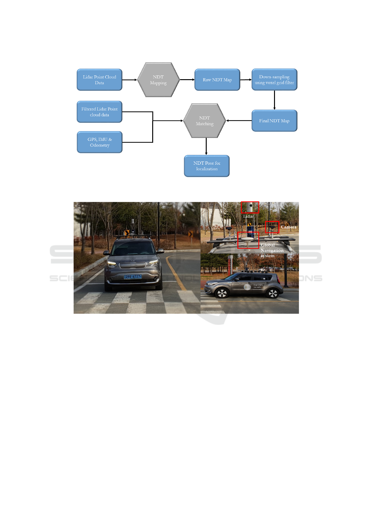
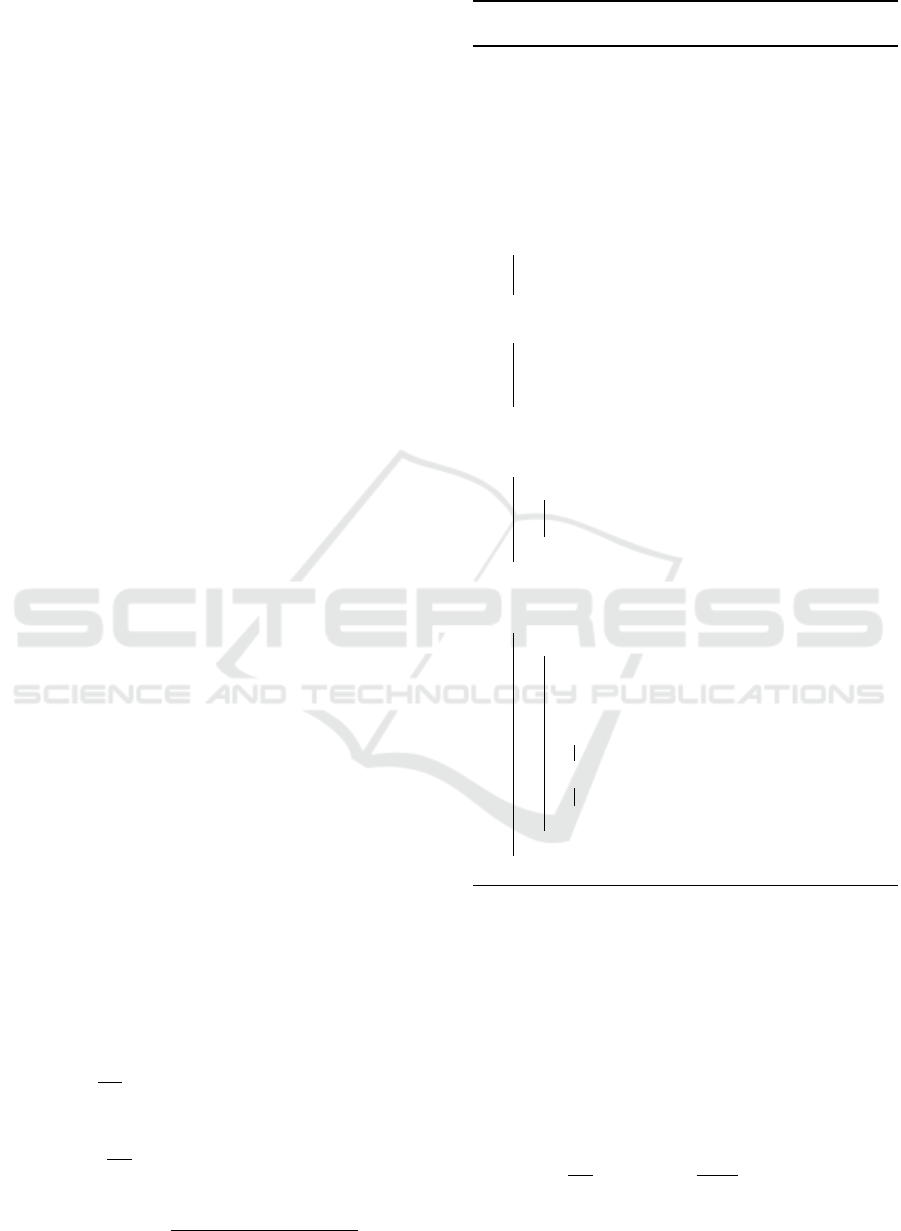
Figure 1: Overall framework for 3D map generation and localization. It takes raw point cloud as input and generates the 3D
map using NDT mapping. It uses NDT matching to localize the self driving car using the information of 3D map and filtered
point cloud data at the current time and searches for the best possible match between map and point cloud data.
Figure 2: MLV-Self Driving Car KIA Soul EV equipped with different sensors being used for collecting the data.
respectively. The m
k
and S
k
are maintained for each
ND voxel k. They are updated when input point cloud
is associated with the reference point cloud. The 3D
coordinate equation to transform input point cloud is
given by equation 6.
w
i
= Rx
i
+t, (6)
where R gives the rotation matrix to rotate euler angle
α, β, γ along z, y, z axis. R is calculated as follows:
R =
cosα −sinα 0
sinα cosα 0
0 0 1
∗
cosβ 0 sinβ
0 1 0
−sinβ 0 cosβ
∗
cosγ −sinγ 0
sinγ cosγ 0
0 0 1
(7)
and t = (t
x
, t
y
, t
z
)
t
is the translation vector. The Eu-
ler angles and translation vector form the param-
eters of NDT mapping and given by vector T =
(α, β, γ, t
x
, t
y
, t
z
)
t
.
2.2 NDT Mapping and Matching
NDT mapping is the module of map generation. Its
schematics is shown in Figure.3 , where the point
clouds are converted to voxel using NDT and are com-
bined together , and also the voxel grid filter is used to
decrease the computation cost and to reduce the noise
from the 3D map. More details of NDT mapping is
described below.
1. Compute NDT of the reference point cloud.
2. Use initial position from odometry to set the ini-
tial position of input point cloud.
3. Apply NDT to input point cloud.
4. For the input cloud select corresponding ND
voxel.
VEHITS 2019 - 5th International Conference on Vehicle Technology and Intelligent Transport Systems
454
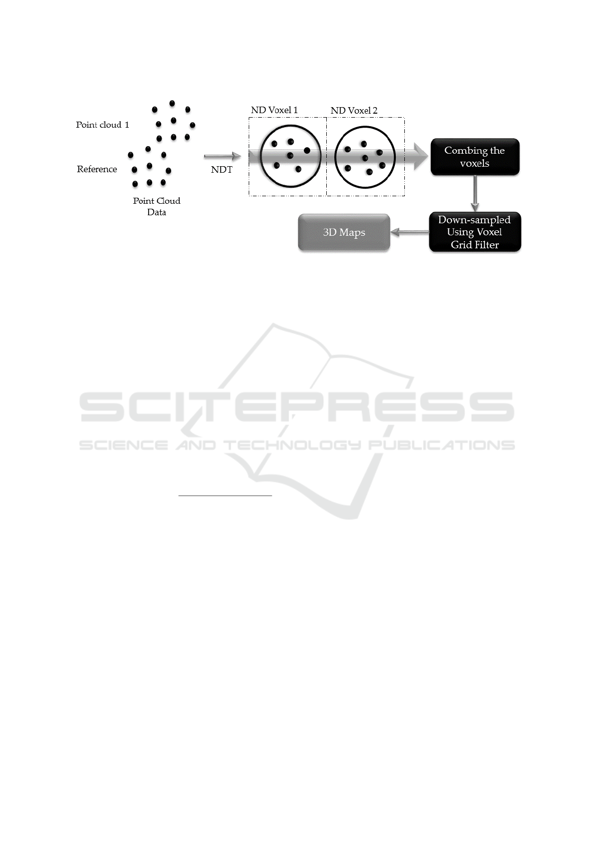
Figure 3: Procedure to make 3D maps for localization.
5. Use the Newton’s method to update parameters.
6. If parameter converges go to 7, else go to 3.
7. Combine the input cloud with the reference point
cloud.
8. Start again from step 2.
Now that we have a map and want to localize,
we need to match our current location information
to the generated map. The matching of the point
cloud is a search problem, which finds the param-
eter T=(α,β,γ,t
x
,t
y
,t
z
) that best transforms the input
point cloud to the reference point cloud. An evalu-
ation function given by equation 7 is used to evaluate
the fitness of the input point cloud to the reference
point cloud. Newton non-linear optimizer is applied
to E(X,T).
E(X, T ) =
N−1
∑
i=1
exp(−
(w
i
− p
i
)
t
∑
−1
i
(w
i
− p
i
)
2
)
(8)
Algorithm 1 explains the NDT mapping and
matching process.
3 DATA COLLECTION
We have developed a platform for autonomous driv-
ing (Munir et al., 2018). It serves as the experimental
setup for the collection of data, testing and evalua-
tion of algorithms. KIA Soul EV is equipped with
state-of-art equipment consisting of 32 channel Lidar,
Novatel Global Navigation satellite System (GNSS)
module and Cameras (Azam et al., 2017). VLP-32
Lidar has been used for collecting point cloud data
of the environment (Azam et al., 2018). It has 32
channel lasers and detectors pairs. It rotates at fre-
quency of 15hz and outputs data at 100Mbps. It can
detect up to 100m. 300,000 points/sec are generated
which specify the X, Y and Z coordinates of object
in the surroundings in Cartesian coordinate system.
The distance of each point is specified from center of
Lidar. The data is collected of Gwangju Institute of
Science and Technology (GIST) using MLV self driv-
ing car shown in Figure 2. Figure 6 shows the map
of GIST, and red path specify the route where the car
was driven to collect the data manually.
4 EXPERIMENTATION
Localization of self driving car in its environment is
of immense importance. The use of point cloud data
in generating the 3D maps solves this predicament of
localization. Normal Distribution Transform mapping
provides an efficient way to develop maps for the en-
vironment. For map generation, approximately 27GB
of raw point cloud data was collected using Lidar. The
generation of map for the whole area in a single at-
tempt, requires a lot of computational power and time.
NDT matching on a system having 12 cores CPU
takes more than 24hrs to process less than 1GB data.
The processing time has been greatly optimized by
the use of GPU with the limitation that large memory
is required for storing the map at runtime. An efficient
method to solve memory issue is to make sub-maps
and combine them later into a complete map. Each
sub-map is downsampled to reduce the data points.
The range accuracy of generated map depends on the
point cloud data. Since the Lidar has 3cm range accu-
racy, the generated map is accurate upto 3cm. Figure
4 shows the generated map of GIST using the point
cloud data.
For the localization, we have used the NDT
matching that gives the estimated position and orien-
tation of the vehicle by matching the best possible in-
Where Am I: Localization and 3D Maps for Autonomous Vehicles
455
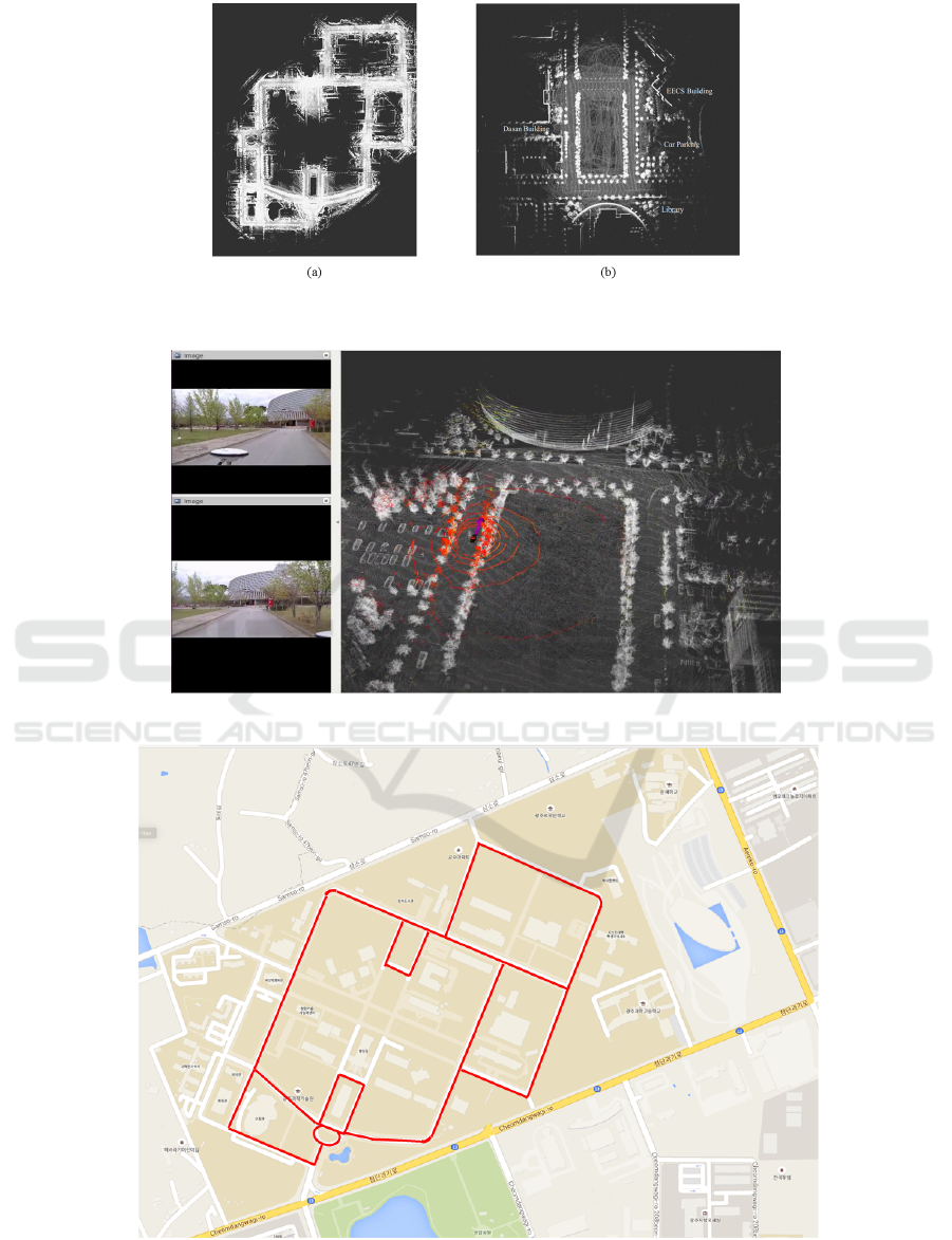
Figure 4: 3D map generated using NDT mapping.(a) Complete GIST map (b) Small portion of map generated for testing the
autonomous driving.
Figure 5: Localization using NDT matching. The arrow shows the pose of vehicle.
Figure 6: GIST Map showing the route of the self driving car.
VEHITS 2019 - 5th International Conference on Vehicle Technology and Intelligent Transport Systems
456

formation between the scan data and the 3D map. Fig-
ure 5 shows the localization results of NDT matching.
5 CONCLUSION
The autonomous driving is the new future of artificial
intelligence and many stakeholders are investing in
this uprising research area. In this paper, we have dis-
cussed the localization for autonomous driving. For
localization, we have to make the 3D map and de-
pending on that map the self driving car can local-
ize itself. We have used NDT mapping algorithm for
generating the 3D map of GIST using our own self-
driving car. Once the map is being built, we have used
NDT matching as scanning algorithm for matching
the current Lidar point cloud to the 3D map which is
being built previously.
The future work includes the use of motion plan-
ning algorithm for path finding depending on the lo-
calization information. Incorporating detection re-
sults to the localization is also in the future work.
ACKNOWLEDGMENT
This work was supported by GIST Research Institute
(GRI) grant funded by the GIST in 2019, and by In-
stitute of Information & Communications Technology
Planning & Evaluation (IITP) grant funded by the Ko-
rea government (MSIT) (No.2014-0-00077, Develop-
ment of global multitarget tracking and event predic-
tion techniques based on realtime large-scale video
analysis)
REFERENCES
Azam, S., Munir, F., Rafique, A., and Jeon, M. (2017).
Multi-sensor data collection and data fusion: A Step
towards Self Driving Car. In The International Con-
ference on Big data, IoT, and Cloud Computing, Jeju,
South Korea.
Azam, S., Munir, F., Rafique, A., Ko, Y., Sheri, A. M., and
Jeon, M. (2018). Object modeling from 3d point cloud
data for self-driving vehicles. In IEEE Intelligent Ve-
hicles Symposium (IV), pages 409–414. IEEE.
Besl, P. J. and McKay, N. D. (1992). Method for regis-
tration of 3-d shapes. In Sensor Fusion IV: Control
Paradigms and Data Structures, volume 1611, pages
586–607. International Society for Optics and Photon-
ics.
Biber, P. and Straßer, W. (2003). The normal distributions
transform: A new approach to laser scan matching. In
IROS, volume 3, pages 2743–2748.
Borrmann, D., Elseberg, J., Lingemann, K., N
¨
uchter, A.,
and Hertzberg, J. (2008). Globally consistent 3d map-
ping with scan matching. Robotics and Autonomous
Systems, 56(2):130–142.
Chetverikov, D., Svirko, D., Stepanov, D., and Krsek, P.
(2002). The trimmed iterative closest point algorithm.
In Pattern Recognition, 2002. Proceedings. 16th In-
ternational Conference on, volume 3, pages 545–548.
IEEE.
Dissanayake, M. G., Newman, P., Clark, S., Durrant-
Whyte, H. F., and Csorba, M. (2001). A solution to
the simultaneous localization and map building (slam)
problem. IEEE Transactions on robotics and automa-
tion, 17(3):229–241.
He, Y., Liang, B., Yang, J., Li, S., and He, J. (2017). An
iterative closest points algorithm for registration of
3d laser scanner point clouds with geometric features.
Sensors, 17(8):1862.
Jo, K., Jo, Y., Suhr, J. K., Jung, H. G., and Sunwoo,
M. (2015). Precise localization of an autonomous
car based on probabilistic noise models of road sur-
face marker features using multiple cameras. IEEE
Transactions on Intelligent Transportation Systems,
16(6):3377–3392.
Karlsson, R. and Gustafsson, F. (2017). The future of
automotive localization algorithms: Available, reli-
able, and scalable localization: Anywhere and any-
time. IEEE signal processing magazine, 34(2):60–69.
Kim, P., Chen, J., and Cho, Y. K. (2018). Slam-driven
robotic mapping and registration of 3d point clouds.
Automation in Construction, 89:38–48.
Munir, F., Azam, S., Hussain, M. I., Sheri, A. M., and Jeon,
M. (2018). Autonomous vehicle: The architecture as-
pect of self driving car. In Proceedings of the 2018 In-
ternational Conference on Sensors, Signal and Image
Processing, SSIP 2018, pages 1–5, New York, NY,
USA. ACM.
Munir, F., Azam, S., Rafique, A., and Jeon, M. (2017). Au-
tomated Labelling of 3d Point Cloud Data. Korean
Information Science Society, pages 769–771.
Prieto, P. G., Mart
´
ın, F., Moreno, L., and Carballeira, J.
(2017). Dendt: 3d-ndt scan matching with differential
evolution. In Control and Automation (MED), 2017
25th Mediterranean Conference on, pages 719–724.
IEEE.
Takeuchi, E. and Tsubouchi, T. (2006). A 3-d scan matching
using improved 3-d normal distributions transform for
mobile robotic mapping. In IROS, pages 3068–3073.
IEEE.
Ulas¸, C. and Temeltas¸, H. (2013). 3d multi-layered nor-
mal distribution transform for fast and long range scan
matching. Journal of Intelligent & Robotic Systems,
71(1):85–108.
Zhou, Q.-Y., Park, J., and Koltun, V. (2018). Open3d: A
modern library for 3d data processing. arXiv preprint
arXiv:1801.09847.
Where Am I: Localization and 3D Maps for Autonomous Vehicles
457
