
Identification of the Impact of GNSS Positioning on the Evaluation of
Informative Speed Adaptation
Jamal Raiyn
Computer Science Department, Al Qasemi Academic College, Israel
Keywords: GNSS Data, Positioning Performance, Autonomous Vehicle, ISA.
Abstract: Autonomous vehicles (AVs) are self-driving vehicles that operate and perform tasks under their own power.
They may possess features such as the capacity to sense environment, collect information, and manage
communications with other vehicles. Many autonomous vehicles in development use a combination of
cameras, various kinds of sensors, GPS, GNSS, radar, and LiDAR, with an on-board computer. These
technologies work together to map the vehicle’s position and its proximity to everything around it. To
estimate AV positioning, GNSS data are used. However, the quality of raw GNSS observables is affected by
a number of factors that originate from satellites, signal propagation, and receivers. The prevailing speed
limit is generally obtained by a real-time map matching process that requires positioning data based on a
GNSS and a digital map with up to date speed limit information. This paper focuses on the identification of
the impact of GNSS positioning error data on the evaluation of informative speed adaptation. It introduces a
new methodology for increasing the accuracy and reliability of positioning information, which is based on a
position error model. Applying the sensitivity analysis method to informative speed adaptation yields
interesting results which show that the performance of informative speed adaptation is positively affected by
minimizing positioning error.
1 INTRODUCTION
For most intelligent transport systems (ITSs), the
impact of the quality of the positioning information
on ITS user service-level performance cannot be
easily estimated. However, it can be of fundamental
importance for critical services, and therefore calls
for detailed analysis. Over the last few years, various
geo-positioning technologies have been used to
estimate the location of vehicles (Du et al. 2004;
Quddus et al., 2007), such as satellite-positioning
technologies (i.e. global navigation satellite systems
[GNSSs], and global positioning systems
[GPSs](Ramm and Schwieger, 2007), wi-fi
positioning systems, and cellular positioning
systems(Alger, 2014; Zandbergern, 2009). Some of
the methods for collecting data on road traffic flow
involve fixed-point modes, with high costs and
limited regional coverage, such as induction loops
and radar and video techniques (Fleming, 2001;
Groves, 2013). In contrast to these fixed-point
modes, we have introduced a system of floating data
management based on augmented GNSS-based
terminal positioning to improve the estimation of
vehicle location, for road ITSs (Raiyn, 2016). The
advantages of GNSS-based positioning are: accuracy
and low processing time complexity. The basic
operating principle of satellite navigation systems is
to calculate a user’s position from a GNSS signal.
However, the quality of raw GNSS measurements
(also called observables) is affected by several
factors that originate from satellites, signal
propagation, and receivers.
This paper is organized as follows: Section 1
gives an overview of the technology used to estimate
AV positioning; section 2 explains the collection of
raw GNSS data; section 3 describes the system
model; section 4 presents the method for identifying
GNSS positioning error; section 5 discusses the
results of the implemented informative speed
adaptation and section 6 concludes the paper.
2 GNSS POSITIONING DATA
In transportation, positioning can be monitored
everywhere, and the number of road transport
systems using positioning systems, for the most part
Raiyn, J.
Identification of the Impact of GNSS Positioning on the Evaluation of Informative Speed Adaptation.
DOI: 10.5220/0007656903050311
In Proceedings of the 5th International Conference on Vehicle Technology and Intelligent Transport Systems (VEHITS 2019), pages 305-311
ISBN: 978-989-758-374-2
Copyright
c
2019 by SCITEPRESS – Science and Technology Publications, Lda. All rights reserved
305

based upon GNSS, is almost infinite. The
requirements of these systems with respect to the
positioning information provided by the positioning
terminal can vary from decimetres to hundreds of
metres, depending on the application. Some of these
systems are critical in terms of the need for safety,
liability or security, and they depend on accurate and
reliable positioning information to function
effectively. For ITSs and LBSs, a standard in 2015
is a single-frequency GPS L1 receiver, with
increasing SBAS and dual-constellation (with
GLONASS) capabilities. LBS receivers
(smartphones) are also often assisted (A-GNSS) by
and even hybridized with positioning based on
communication networks. The ability to use multiple
GNSSs improves the accuracy, integrity and
availability of positioning, especially in urban areas.
There is a very large offer of different types of
GNSS receivers today, with highly variable
performances and costs. The performance of a
GNSS may be improved by data fusion, namely by
integrating sensor measurements, other positioning
means or a priori data such as digital data bases.
This data fusion brings enhancement at three levels:
(1) standard position, velocity and time (PVT) are
improved in terms of availability, accuracy, and
integrity; (2) additional information, such as attitude
angles, may be provided, and (3) the output rate is
increased by one or two orders of magnitude. One of
the most influential trends in GNSS is the use of
multiple systems to achieve better error mitigation
(e.g. multipath), resistance to interference and
positioning accuracy. Ground and satellite based
augmentation systems will also be used more in the
future to improved position accuracy and integrity.
Furthermore, in this project we will consider cyber
and information security in an augmented GNSS,
which may influence PVT.
The GNSS positioning principle relies on
trilateration by which an unknown point location
(receiver) is estimated using distance measurements
observed from known point locations
(satellites)(Groves, 2013). The basic observable of
the system is the travel time required for a signal to
propagate from the satellite to the receiver
multiplied by the speed of light to compute distance.
The receiver could then be located anywhere on the
surface of a sphere centered on the satellite with a
radius that equals this distance. The quality of raw
GNSS observables is affected by several factors
originating from satellites, signal propagation, and
receivers. The signal transmitted by a satellite
propagates through the atmosphere, where it is
subject to delays caused by the ionosphere and
troposphere. The effects of these delays are only
partially compensated for by global models in single
frequency receivers.
At the ground level, multipath, namely the
reception of signals reflected from objects like
buildings surrounding the receiver, can occur,
inducing one of the largest errors that is difficult to
model, as it is strongly depends on the receiver
environment. The worst situations are experienced
when only reflected signals are received (non-line-
of-sight signals, or (NLOS) signals, resulting in
pseudo-range errors of several tens of metres or
greater in extreme cases.
Finally, random errors are encountered at the
receiver level due to receiver thermal noise. The
receiver clock offset (much larger than that of the
satellite) does not create any error, since it is
considered as an unknown and is calculated together
with the position. The position error that results from
the measurement errors above, which is referred to
as dilution of precision (DOP) depends also on the
relative geometry between the receiver and the
satellites. Accuracy is maximized when the
directions to tracked satellites are more uniformly
spread around the receiver.
The main task of a GNSS is to provide
localization and time synchronization services.
There are multiple GNSS systems available. The
most well-known one is the global positioning
system (GPS). GPS data is transmitted via
coarse/acquisition (C/A) code, which consists of
unencrypted navigation data. The encrypted
(military) signal is called the precision-code, which
is also broadcast by every satellite. It has it is own
PRN codes, but it is in the order of 1012 bits long.
When locked onto the signal, the receiver receives
the Y code, which is an encrypted signal with an
unspecified W code (Loukas et al., 2013;
Humphreys, 2013). Only authorized users can
decipher this. In later GPS satellites, extra features
were added (Radoslav et al., 2014; Uma and
Padmavathi, 2013). There are several methods of
augmenting GNSS data to get better estimates of
location. Three of these are satellite-based
augmentation systems (SBASs), assisted-GPS, and
differential-GPS. SBASs were the first type to be
developed; these systems are commonly used in
airplanes, for critical phases such as the landing
phase. They consist of a few satellites and many
ground stations. A SBAS covers a certain GNSS for
a specific area, and for every GNSS, accuracy
depends heavily on, and is influenced by external
factors (Grove, 2013). These factors affect not only
GNSS applications, but also every other wireless
VEHITS 2019 - 5th International Conference on Vehicle Technology and Intelligent Transport Systems
306
transmission application. Furthermore, the satellites
orbit the earth at a height of approximate 20.000 km,
and at this height, signals can be affected in many
ways. According to (Grove, 2017), “space weather”,
and solar conditions affect signals too. A GNSS
requires exact timing on the order of nanoseconds to
determine position, but when, a satellite signal
reaches earth, it can reflect from buildings and other
objects, causing an increase in travel time and
influencing measurements.
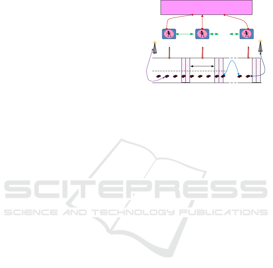
3 SYSTEM MODEL
In this model, the urban road is divided into sections,
and each road section is assigned an intelligent
vehicle agent (IVA). The goal of the IVA is to
manage the adaptive traffic and to serve the
autonomous vehicle.
The functionality of the system model works on
three levels: the performance of the GNSS- based
positioning terminal, and the performance of the
system at the service error level. Autonomous
vehicles (AVs) are sometimes referred to as
driverless vehicles or self-driving vehicles. They
offer many advantages and are expected to appear
on the commercial market by 2030. Comfort is one
obvious advantage, but in the current society, the
practical advantages of AVs become clearer every
day. Due to increased congestion on roads,
productivity decreases and money is wasted on fuel
and time. Cooperative AVs (Jawhar et al., 2013)
enhance traffic flow, and in regard to road safety,
smart vehicles are likely to decrease the number of
injuries and fatalities. AVs collect information from
the environment during their activity. However,
these autonomous technologies are subject to
malicious input, and are lacking in security. From a
security-by-design perspective this is wrong,
because a decision made by an AV is only as good
as the sensors can perceive. A faulty observation can
lead to dangerous situations.
4 METHODOLOGY
The performance of any system can be characterized
with respect to different features, or characteristics.
For ITS and mobility applications, the most relevant
performance features are availability, accuracy and
integrity. These features can be relevant for different
outputs of the terminal, such as horizontal position,
altitude, longitudinal speed, etc. As a result, a large
Figure 1: System model.
number of combinations of features and outputs can
be assessed during the performance characterization
of a positioning terminal. Each characterization
process calls for a performance metric (or indicator).
A performance metric involves a precise definition
of the means of measuring a given performance
feature of a given system output. A performance
metric is necessarily associated with a standardized
test protocol defining the test procedures and means
(test vehicle, simulator, record and replay
equipment, etc.), the test scenario and the way the
test results will be transformed into indicators. The
test scenario should precisely define the set-up
conditions of the terminal (in particular of the GNSS
receiver antenna), the trajectory, the sample size, the
environmental conditions, the interference
conditions, so forth. It should reflect as faithfully as
possible the real operational conditions under which
the ITS system using the positioning terminal will
operate.
Availability in ITS
Availability refers to the percentage of time
during which the output of the positioning terminal
is available. This feature can be defined in many
different ways according to the needs of the
application. In general, availability refers to the
percentage of the measurement epochs (time
periods) when the considered output is delivered
with the required performance. A more
straightforward metric would simply be the
percentage of the measurement epochs when the
considered output is delivered by the terminal,
regardless of its quality.
Accuracy in ITS
This feature refers to the statistical
representation of the merit of position error, velocity
error or speed error. Accuracy metrics have to be
constructed based on the statistical distribution of
errors.
5G
intelligent cooperative traffic control algorithm
V2V
V2I
section i section j
critical zone
IVAi IVAj IVAn
section n
V2IoT
Identification of the Impact of GNSS Positioning on the Evaluation of Informative Speed Adaptation
307
Integrity in ITS
The concept of integrity was introduced in civil
aviation to measure performance affecting safety, for
example, executing a safe landing. It is not enough
that errors be small on average (accuracy); they must
remain small for every landing (integrity). Given the
focus of this document, dedicated to road transport
and mobility, the definitions for integrity are
inspired by, but significantly simpler than, the
definitions used by the civil aviation community.
High accuracy does not mean high integrity.
4.1 Positioning Error Modelling (PEM)
Position error modeling is mandatory for a
sensitivity analysis that checks for the compatibility
of a given position terminal with a given application
algorithm in a given environment. In view of what
we have mentioned in previous sections, it is
challenging to model errors at the level of raw
measurements (or observables) and to propagate this
model through the navigation algorithm, which most
of the time is unknown and is always non-linear.
The most efficient method is to identify a model that
captures real errors observed at the position error
modeling level as closely as possible. The proposed
methodology applies to various environments, which
calls for a variety of models.
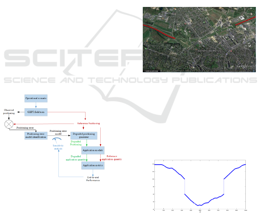
Figure 2 illustrates the sensitivity analysis, which is
based on field tests of a GNSS-based positioning
terminal (GBPT) carried out under real conditions to
identify a positioning error model.
Figure 2: Operational scenario.
4.2 Quality of GNSS Data
AVs may receive data from various sources. The
central monitor has the task of measuring the quality
of received data in the AV network. There are two
kinds of data: data for travel forecasting (Broggi et
al., 2013; Ramm and Schwieger, 2007) and data for
vehicle positioning estimation (Alger, 2014). In
general, data quality is defined as data that is
suitable for use (Raiyn, 2017). In AVs data quality
involves delivering the right data to the right user at
the right time and correct data enables the making of
reliable, and accurate decisions. Low quality data
can lead to traffic congestion and collision. In
general, there are three main approaches that use
performance metrics to test the global performance
of a GNSS-based positioning terminal: filed tests,
lab tests, and record and replay tests. This section
discusses the impact of these approaches.
Field Tests
Field tests were performed by SaPPART to
collect data. The car used was equipped with uBlox
and smartphones. Figure 3 illustrates the data
collection in North Paris. The data are incomplete
due to urban noise produced by network tunnels.
Figure 3: Field tests.
Lab Tests
Simulations were carried out using MATLAB,
due to the fact that the observations of the traffic
were incomplete and were a noisy function of the
unobservable state process which can be observed
only through noise measurements. In cases where
the system received incomplete GNSS data as
illustrated Figure 4, the system combined historical
GNSS data with map matching to supply the missing
data.
Figure 4: Lab tests.
VEHITS 2019 - 5th International Conference on Vehicle Technology and Intelligent Transport Systems
308

The newly received data set was compared to the
available data set. Innovative data were
characterized by statistical measurement as
illustrated in Figure 5.
Figure 5: Data analysis based on SEM.
4.3 Algorithm Description
The algorithm describes the message exchanges
between an intelligent vehicle agent (IVA) and an
AV. The IVA updates the AV about the urban road
traffic through a communications protocol based on
message exchanges.
Algorithm I: send message
for all AV
i
do
At ts
1,
leader sends its current acceleration and speed
At ts
j-1,
AV
j
receives its current speed v
c
and acceleration
At ts
j
, leader gets from IAV
j
End for
Algorithm II: received message
for all AV
i
do
At ts
1,
autonomous vehicle AV
j
receives the acceleration and
speed v
c
from the leader
At ts
j-1,
AV
j
receives the acceleration from its precedent vehicle
At ts
j,
AV
j
transmits its current acceleration to its follower
End for
Algorithm III: compute forecasting speed
for all AV
i
do
At ts
1,
leader computes its forecasting speed
At ts
1,
leader sends its next acceleration and speed
forecasting
At ts
j,
leader gets from IVA
j
computed next acceleration
to use at the next updating cycle
End for
Algorithm IV: follower strategy
for all AV
i
do
At ts
1
, AV
j
receives the acceleration and speed
from the leader
At tsj-1, AV
j
computes its predicted speed based on its
current acceleration
At tsj-1, AV
j
compute its next acceleration
At tsj, AV
j
transmits its next acceleration to its follower
End for
4.4 Informative Speed Adaption
Informative speed adaptation (ISA) uses the
exponential moving average (EMA) scheme for
travel speed forecasting. The algorithm forecasts
travel observations based on the EMA for the
designated urban road. Its procedure is as follows.
4.4.1 Short-Term Forecasting based on
Historical Information
The historical database is a collection of past travel
observations of the system. The exponential
smoothing forecasting method gives unequal weight
to the observed time series. This is accomplished by
using one or more smoothing parameters, which
determine how much weight is given to each
observation. The major advantage of the exponential
smoothing method is that it provides good forecasts
for a wide variety of applications. In addition, the
data storage and computing requirements are
minimal, which makes exponential smoothing
suitable for real-time forecasting.
),()1(),(),1( ktttktttkttt
HM
(1)
where
10
, tt
M
(t, k) is the actual travel time
in section k at time t, and tt
H
(t, k) is the historical
travel time in section k at time t.
4.4.2 Short- Term Forecasting based on RT
Information
The occurrence of abnormal conditions in traffic
flow travel information decreases of forecasts based
on historical information and may increase the
complexity of the forecasting of unusual incidents.
The forecasting model based on real-time
information gives a little weight to historical
information and great weight to real-time
observations.
)),(),((),1(),1( ktttktttktttkttt
HMH
(2)
where
10
.
4.5 Description of the Positioning Error
The ISA application is based on geo-objects
specified by latitude and longitude. Positioning
errors and angle errors were cloned and these clones
were combined to create “clone trajectories”. The
reference trajectory was used, and the clone points
were computed by adding cloned radius and angles
into reference points as illustrated in figure 6.
Identification of the Impact of GNSS Positioning on the Evaluation of Informative Speed Adaptation
309
x
cloned
= x
ref
+sin(yaw
ref
–Angle)*Radius (3)
y
cloned
=y
ref
+cos(yaw
ref
–Angle)*Radius (4)
Figure 6: Positioning error model.
5 IMPLEMENTATION
This section describes informative speed adaptation
(ISA). The algorithm introduced here and used for
informative speed adaptation (ISA) is also known as
an intelligent speed limiter, or intelligent speed
assistance, or an intelligent speed alerting or
intelligent speed authority. The purpose of ISA is to
mitigate speeding, (i.e., drivers’ travelling at speeds
above the legal speed limit). This is accomplished by
informing or alerting the driver, or even by taking
control of the vehicle, depending on the system
design. The prevailing speed limit is generally
obtained through a real-time map-matching process
that requires localization via GNSS and a digital
map with up-to-date speed limit information.
Applying a GNSS to calculate travel time has
proved to be effective in terms of accuracy. In this
case, GNSS data are managed to reduce traffic
congestion and road accidents.
The road is divided into sections as illustrated in
Figure 7. For each section the speed has been
forecast based on real-time travel observations. The
IVA system updates each AV on the speed limit in
each section. An intelligent vehicle agent (IVA)
updates each AV on the travel speed in its road
section. Figure 8 illustrates the impact of GNSS
positioning error on the evaluation of ISA. In
sections where the GNSS positioning error is high,
the traffic congestion is greater (red color). Figure 9
shows that the performance of ISA is improved by
positioning error correction. Figure 10 illustrates the
short term travel forecasts for road sections. The
travel forecasting is based on exponential moving
average with the optimization of alpha and gamma.
Figure 11 illustrates the evaluation of the
forecast scheme EMA. The root mean square error
increases in sections where GNSS positioning error
is high.
E
D
CA
B
F
G
Figure 7: Road partitioning.
Figure 8: Travel speed.
Figure 9: Positioning correction.
Figure 10: Mean travel speed prediction.
VEHITS 2019 - 5th International Conference on Vehicle Technology and Intelligent Transport Systems
310

Figure 11: Root mean square error.
6 CONCLUSION AND FUTURE
WORK
In general, schemes that have been proposed involve
forms of centralized management, which may
achieve near- optimum performance in whole
systems in regard to maximum capacity. However,
as the number of vehicles increases, centralized
computation may become mathematically
intractable. Such schemes are also impractical when
traffic varies significantly and creates difficulties for
measuring actual conditions. The major
disadvantage of centralized management is the
occurrence of deadlock, which causes the whole
system to collapse. To reduce the overload in
computational management time, we consider the
management of urban road traffic in distributed
form, and for this, we propose the use of
decentralized management. The proposed approach
is based on intelligent vehicle agent techniques; it
aims to reduce several types of traffic congestion
and their effects, such as delays, waiting time, driver
stress, air and noise pollution, and economic costs.
Informative speed adaptation is used to update AVs
in order to determine the shortest route from the
source to the destination node based on short- term
forecasting. The update phase is used to inform the
AVs about new events during the trip, and the
updated information is used to reduce road traffic
congestion. In keeping with the updated information,
vehicles are allocated the appropriate road sections,
and drivers can select new sections with low traffic
congestion.
REFERENCES
Alger, M., 2014. Real-Time Traffic Monitoring Using
Mobile Phone Data, Proceedings of 49th European
Study European Study Group with Industry, Oxford,
United Kingdom.
Broggi, A. et al., 2013. Extensive Tests of Autonomous
Driving Technologies, IEEE Transactions on
Intelligent Transportation Systems 14.3. pp. 1403–
1415.
Du, J., Masters, J. , Barth, M., 2004. Lane-Level
Positioning for In-Vehicle Navigation and Automated
Vehicle Location (AVL) Systems. 2004 IEEE
Intelligent Transportation Systems Conference, pp. 1–
3.
Fleming, W. J. J. 2001. Overview of automotive sensors.
IEEE Sensors Journal 1.4, pp.
296–308.
Groves, P.D. 2011. Shadow Matching: A New GNSS
Positioning Technique for Urban Canyons. The
Journal of Navigation, 64, pp.417–430.
Groves. D.P., 2013. Principles of GNSS, inertial, and
multisensor integrated navigation systems. Artech
house.
Loukas, G., Gan, D., Vuong, T. 2013. A Review of Cyber
Threats and Defence Approaches in Emergency
Management. In: Future Internet 5.2, pp. 205–236.
Humphreys,T.E. 2013. Detection Strategy for
Cryptographic GNSS Anti-Spoofing. In: IEEE
Transactions on Aerospace and Electronic Systems
49.2 . pp. 1073–1090.
Jawhar, I., Mohamed,N., Usmani, H. 2013. An Overview
of Inter-Vehicular Communication Systems, Protocols
and Middleware. Journal of Networks 8.12 (Dec.
2013), pp. 2749–2761.
Quddus, M.A. Ochieng, W.Y,. Noland, R.B.. 2007.
Current map-matching algorithms for transport
applications: State-of-the art and future research
directions, Transportation Research Part C 15. pp.
312–328.
Ramm, K. and Schwieger, V., 2007. Mobile positioning
for traffic state acquisition, J. Location Serv.; 1(2).
pp. 133–144.
Radoslav , I., Pajic, M. Lee., I. 2014. Attack-resilient
sensor fusion. Proceedings of the conference on
Design, Automation & Test in Europe. European
Design and Automation Association., p. 54.
Raiyn,J., 2016. Speed Adaptation in Urban Road Network
Management, Transport and Telecommunication, 17,
2. pp. 11-121.
Raiyn, J. 2017. Road traffic congestion management based
on search allocation approach, Transport and
Telecommunication. 18. (1). pp. 25-33.
Uma, M. Padmavathi,G. 2013. A Survey on Various
Cyber Attacks and their Classification, International
Journal of Network Security, vol. 15, no. 6, , pp. 391-
397.
Zandbergen, A.P., 2009. Accuracy of iPhone Locations: A
Comparison of Assisted GPS, WiFi and Cellular
Positioning, Transactions in GIS, 13(1), pp. 5-16.
Identification of the Impact of GNSS Positioning on the Evaluation of Informative Speed Adaptation
311
