
Mapping Atmospheric – Ocean Parameter Risk Index based on
Meteorological Review to Support the Operational Work of Sea Toll
Road Program
Anistia M. Hidayat
1,a
, Ayuna S. Putri
1,b
, Faqih Musyaffa
1,c
, and Ahmad Fadlan
2,d
1
Undergraduate Program of Meteorology, STMKG, Banten, Indonesia
2
Lecturer, Department of Meteorology, STMKG, Banten, Indonesia
Keywords: Atmosphere, Ocean, Safety, Sea Toll Road Project.
Abstract: Indonesia is the largest archipelagic state in the world, two-third of its total area is a marine region. It is such
enlightenment when the current government is aware of Indonesia's marine potential and prioritizes policies
that support maritime transport through a concept known as the Sea Toll Road project. According to this
project, safety factors such as environmental hazards need to be put under serious consideration. ECMWF
ERA-Interim Reanalysis for wind data, daily rainfall data from TRMM, and WaveWatch III model data in
2013 have been adjusted to determine and assess the safety risk threshold for each parameter. This information
is used as the basic data for mapping spatial distribution of wind, rainfall, and wave height profile in each
period of the months. The atmospheric–ocean parameter risk index map shows that in the active monsoon
period, the closed seawater over Indonesia generally tends to possess a higher risk level of sailing, especially
for a barge. During Asian Monsoon, high-risk levels exist at the range index 5-7 which occurs on the north
part of the Indonesian sea while in the Australian monsoon period that index happens on the south part of the
Indonesian sea. Therefore, this risk index within the map is important to be used as a sailing warning for
supporting the safety of the Sea Toll Road project and to reduce the accident rates during shipping activities.
1 INTRODUCTION
As the largest archipelagic country in the world,
Indonesia has a wider marine region than its land
area. Based on the United Nations Convention on the
Law of the Sea (UNCLOS) 1982, Indonesia's total
marine area is around 5.9 million km2, with coastline
reaching up to 95,161 km, second-longest after
Canada (Lasabuda et al., 2013). Realizing this
potential sector, the government has issued several
policies to actualize Indonesia's vision to become the
world's maritime axis. The concept of "Sea Toll" was
later introduced and became one of the most limelight
policies in recent years.
The concept of Sea Toll Road is likely to become
the most awaited policies, especially for those who
work in the marine transportation sector. Nearly
99.5% of the movement of the world's economy is
done through the sea (Kadarisman et al., 2016).
During hustle and bustle discussion about the
program, shipping safety has become an important
issue that has not received much attention. Based on
historical data, natural factors, both in the form of bad
weather and high waves, have the most influence on
the incidence of ship accidents (Rahman et al., 2017).
Furthermore, research related to the condition of the
Indonesian sea and its relationship to safety has not
been widely studied. Whereas, knowing the condition
of the sea waters is the main requirement for ship's
crew and fishermen before they go to sea.
Some of the atmospheric-ocean parameters that
affect shipping safety are surface wind conditions,
rainfall, and wave height. Heavy rainfall causes
visibility to decrease, while the direction and velocity
of wind have a strong relation to the variation of wave
height. Weather factors such as wind and waves are
very important for ship movement, especially related
to their safety (Pranowo et al., 2012; Wicaksana et al.,
2015).
Based on the explanation above, this research
aims to analyze three atmospheric-ocean parameters
to provide information about the risk profile of sailing
safety as an effort to support the Sea Toll Road
program. Recent research conducted in Surabaya-
Hidayat, A., Putri, A., Musyaffa, F. and Fadlan, A.
Mapping Atmospheric: Ocean Parameter Risk Index based on Meteorological Review to Support the Operational Work of Sea Toll Road Program.
DOI: 10.5220/0010863800003261
In Proceedings of the 4th International Conference on Marine Technology (senta 2019) - Transforming Maritime Technology for Fair and Sustainable Development in the Era of Industrial
Revolution 4.0, pages 19-29
ISBN: 978-989-758-557-9; ISSN: 2795-4579
Copyright
c
2022 by SCITEPRESS – Science and Technology Publications, Lda. All rights reserved
19

Makassar shipping trajectory has concluded that
weather patterns, essentially for rainfall, the height of
the sea waves, and the speed of the ocean currents
could be used as fundamental elements to recognize
maritime weather patterns to determine the safety of
the ship (Lutfiana and Tirono, 2013). Therefore, the
final objective of this research is mapping the sea-
atmosphere parameter risk profile index of the
Indonesian marine region, so that areas that have
potential bad weather in certain months of normal
years can be informed as a warning to the public. In
the future, this map is expected to reduce the number
of transportation accidents over the Indonesian sea.
The success of this study will give good impacts in
terms of practical meteorology and contribute some
benefits for infrastructure development, economy,
mobility, and most importantly shipping safety.
2 DATA AND METHODOLOGY
This study was conducted over the Indonesian sea and
used three atmospheric – ocean parameters, such as
wave height, rainfall intensity, wind direction, and
wind speed. The data then analyzed to obtain
atmospheric – ocean parameter risk index. The
research period in this study was determined in 2013
since it was the latest normal year, a year without any
atmospheric – ocean disturbances.
2.1 ECMWF Reanalysis Wind Data
One of the products of the European Centre for
Medium-Range Weather Forecast (ECMWF) model
is reanalysis data. ERA-Interim reanalysis data used
in this study consists of u-wind component (zonal)
and v-wind component (meridional), also the
parameters of wind speed at 10 m altitudes. ECMWF
reanalysis data is numerical prediction data with the
highest verification level in the world. In addition,
wind model data of ECMWF showed a relatively
similar pattern with wind data obtained from
observation by BMKG in September 2008
(Krisdiantoro, 2012).
2.2 WaveWatch III Model Data
Based on WMO guidelines (1998), for wave
climatology analysis, data can be obtained from two
main sources, namely: (a) measurement and
observation results, and (b) estimation results based
on wind data (wave hindcast). Data from
measurement and observation at sea are generally
very limited and not continuous. Therefore, in this
study, WaveWatch III model is used to obtain
significant wave height data. The WaveWatch III
model is a third generation (III) model developed by
National Centers for Environmental Prediction
(NCEP). This system has a global domain with the
resolution of 50 km. Suratno (1997) shows that the
results of verification between WaveWatch III model
with vessel data obtained a correlation above 0.6.
Based on research conducted by Kurniawan et al.
(2012), wave characteristics over the Indonesian sea
have patterns associated with monsoonal wind cycles.
The pattern of monthly variations in high-wave and
high-frequency waves in most of the Indonesian
territorial marine areas has two peaks that occurred in
the Asian monsoon period (December-January-
February (DJF)) and Australia monsoon period (June-
July-August (JJA)).
2.3 TRMM Rainfall Data
TRMM rainfall data is a joint space mission between
the National Aeronautics and Space Administration
(NASA) and Japan Aerospace Exploration Agency
(JAXA) designed to monitor and study rainfall
variations over the tropical region. Bowman (2015)
showed that when comparing land-based gauges with
TRMM, the correlations are substantially increased
by time-averaging the gauge data between the two
measurements for gauge-average periods of about 2
to 10 h. Maximum correlation coefficients are in the
range of 0.6 to 0.7. Moreover, Schumacher and
Houze (2000) assessed the performance of TRMM by
comparing the data with Kwajalein oceanic validation
radar, it showed that the data agree well within the
range of sensitivity of the precipitation radar.
2.4 Analysis Process
Three atmospheric – ocean parameters data then
spatially processed using the Grid Analysis and
Display System (GrADS) to understand the monthly
characteristics of each parameter. TRMM daily
rainfall data (mm/day) is available in .nc format and
then plotted as the monthly average. The GrADS
provides programming tools and an execution
environment to ease program development for the
grid (Cooper et al., 2004).
The increasing frequency of maritime
transportation accidents in Indonesia has recently
become increasingly alarming. Several accidents
occurred in the sea, both sinking of ships and
collisions between ships (Lutfiana and Tirono, 2013).
One of the factors that can cause collisions between
ships is the decrease of visibility due to rain events
senta 2019 - The International Conference on Marine Technology (SENTA)
20

occurred over the region. Categorization of rainfall
data was based on the press release of the National
Agency for Meteorology Climatology and
Geophysics (2010), as shown in Table 1.
Table 1: Criteria for rainfall intensity in Indonesia.
Categor
y
Rainfall intensity (mm/day)
Li
g
ht 5
–
20
Moderate 20
–
50
Heav
y
50
–
100
Very Heav
y
>100
The wind parameter is also categorized based on
its risk level on shipping safety, especially over a
barge (Table 2). The barge was selected to be a
standard model of transportation modes since the
progress in infrastructure development in the last two
years has been increased significantly. Many barges
serve the distribution of infrastructure materials such
as cement, stone, and sand for infrastructure
development. Barge business also uplifted
significantly, followed by an increase in demand for
coal shipments (Simorangkir, 2017). Surface wind
data is the result of ECMWF models in .nc format and
then processed to determine the monthly
characteristics of wind direction and speed using
GrADS.
Table 2: Criteria for wind parameter in Indonesia.
Categor
y
Win
d
speed (knots)
Very low <7
Low 7
–
10
Moderate 10
–
16
Hi
g
h >16
Table 2 shows that if the wind speed is less than 7
knots, it possesses a very low-risk level for the
shipping activities of the barge. If the wind speed
reaches 7 – 10 knots, then the cruise risk level is
relatively low. Meanwhile, if the wind speed ranges
from 10 – 16 knots, the cruise risk level is categorized
to be moderate. Whereas if the wind speed reaches
more than 16 knots, the risk level of the shipping
activities is said to be high.
Significant wave height data used in this study is
available in .nc format. The data is then processed to
understand the monthly characteristics of the wave
height using GrADS. In marine practical meteorology,
significant wave height terminology is often used to
express ocean wave height. Based on data records,
significant wave height is defined as the average height
of 1/3 of the highest waves, which is equivalent to the
wave height of visual observations (WMO, 1998). The
equation for calculating the significant wave height is
explained by Wara (2019) as follows:
𝐻
1
1
3
𝑁
𝐻
(1)
Interpretation of wave height variations towards
shipping safety based on information provided by the
Indonesian Agency of Meteorology Climatology and
Geophysics. Table 3 shows that the wave height
which is less than 0.75 m has a very low-risk level
(safe) for the shipping activities of the barge. If the
wave height reaches 0.75 - 1.0 m, then the cruise risk
level is relatively low. Meanwhile, if the wave height
ranges from 1 - 1.5 m, the fishermen should be
vigilant because the risk level of sailing is said to be
moderate. Whereas if the wave height reaches more
than 1.5 m, the risk level of the sailing activities is
said to be high and fishermen are generally advised
not to go to sea. In every coordinate, the value of each
parameter is then categorized into 4 index values and
summarized in Table 4.
Table 4: Quantification of index values on each parameter.
Paramete
r
Paramete
r
value Index Value
Wave height < 0.75
m
1
0.75
–
1.0
m
2
1.0
–
1.5
m
3
>1.5
m
4
Wind speed < 7 knots 1
7
–
10 knots 2
10
–
16 knots 3
> 16 knots 4
Rainfall intensity 5
–
20 mm/da
y
1
20
–
50 mm/da
y
2
50
–
100 mm/da
y
3
>100 mm/da
y
4
After defining the index value for each parameter,
the risk profile of atmospheric-ocean parameters is
then determined based on the sum of these three
parameters, with the maximum total index for these
parameters is 12 and the minimum value is 1. The
determination of the criteria will be adjusted
according to Table 5 below:
Table 3: Criteria for significant wave height in Indonesia.
Categor
y
Wave height (meter)
Very low <0.75
Low 0.75
–
1.0
Moderate 1.0
–
1.5
Hi
g
h>1.5
Mapping Atmospheric: Ocean Parameter Risk Index based on Meteorological Review to Support the Operational Work of Sea Toll Road
Program
21

Table 5: Risk index determination based on total index.
No Total Risk profile
1 1
–
3 Low
2 4
–
6 Moderate
3 7
–
9 High
4 10
–
12 Ver
y
hi
g
h
Risk profile naming is adjusted to the risk matrix
product issued by BMKG (2018). The total index is
the value obtained from the sum of the index values
of the three parameters used. This value is then used
as a basis for determining the atmospheric-ocean
parameter risk index as information about the risk
profile of weather conditions on shipping safety. The
total index value or herein after referred to as the risk
matrix level is mapped using Q-Geographic
Information System (QGIS) to analyse the monthly
risk profile of shipping security. QGIS is open-source
software that lets users visualize, question, analyze,
and interpret geographical data (Shaira, et al., 2020).
3 MONTHLY AVERAGE OF
ATMOSPHERIC – OCEAN
CONDITIONS
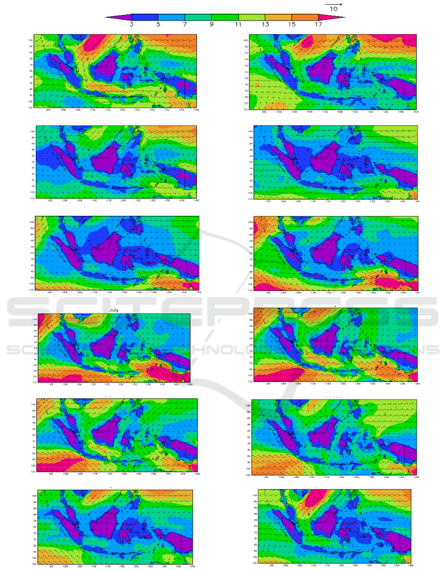
3.1 Wind Profile over Indonesian Sea
The wind parameter is a wave generator factor in the
free ocean. Kisnarti (2012) in her research on
meteorological-oceanography studies for shipping
operations said that wind is the main generator of
waves. The wind that blows above the surface of the
water will move its energy into the water. Wind speed
will cause stress on the surface of the water which is
initially calm and will be disturbed and there will be
ripples or waves above the surface of the water. If the
wind speed increases, the ripples become larger and
when the wind blows continuously a wave will
eventually form. The longer and the stronger the wind
blows, the larger the waves form. The height and
period of the wave generated by the wind are
influenced by wind speed, wind duration, wind
direction, and fetch (Wibisono, 2005).
Generally, the characteristics of waves in
Indonesian sea waters have patterns associated with
the monsoonal wind cycle. The waters of the high
seas that are directly related to the oceans generally
have higher sea waves compared to closed waters
between islands. In the Asian monsoon period (DJF)
in 2013 (Figure 1), wind speed generally starts to
increase in December and gets stronger in January
then begins to weaker in February. January possesses
the strongest wind distributed around the South China
Sea and the Pacific Ocean with velocity ranges from
13 up to more than 17 knots. This condition is really
dangerous for a barge to sail. The wind speed around
Karimata Strait ranges from 9 – 13 knots, becomes
stronger when the seawater flows over the Java Sea
region, and again decreases over the Banda Sea,
Arafura Sea, and the Timor Sea along with the
general direction flow of the wind that from Asia to
Australia region. The weakest wind region was
distributed around Makassar Strait and the Molucca
Sea with ranges from 5 – 7 knots.
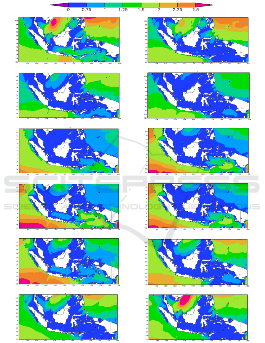
3.2 Significant Wave Height
Variability
Waves are an important factor in marine
meteorological information services (WMO, 2001).
Frequent high waves can cause disruption on fishing
activities, inter-island sea transportation which can
impact lives, scarcity of foodstuffs on several islands,
and various types of work due to constrained supply
of construction materials. In comparison to other
types of waves, waves due to wind are the most
dominant waves occurring at sea level, both in terms
of frequency of occurrence and energy (Hutabarat and
Evans, 2008). The existence of waves due to wind on
the sea surface affects almost all marine activities and
therefore information about these waves is an
important part of marine meteorological information
services.
Kurniawan et al. (2012) stated that the
characteristics of the wave over the Indonesian sea
have patterns associated with monsoonal cycles.
Figure 2 shows the variation of the significant wave
from month to month in 2013. In the Asian monsoon
period, the wave height around the strait region in the
Indonesian sea commonly ranges from 0 – 1 meter. In
January 2013, the wave height around the Java Sea,
some parts of Banda Sea, and Timor and Arafura Sea
can reach up to 1 – 1.5 meter, which is dangerous for
a barge to sail. When it comes to the transition period
of MAM, Indonesian seas dominantly calm because
the wave height was around 0 – 0.75 m. However,
some parts of Arafura and Timor Sea start to increase
senta 2019 - The International Conference on Marine Technology (SENTA)
22
(
a
)
Januar
y
(
b
)
Februar
y
(c) March (d) April
(e) Ma
y
(f) June
(g)
Jul
y
(
h
)
Au
g
ust
(i) Septembe
r
(j) Octobe
r
(k) Novembe
r
(l) Decembe
r
Figure 1: Wind speed and direction monthly profile over Indonesian sea in 2013.
Mapping Atmospheric: Ocean Parameter Risk Index based on Meteorological Review to Support the Operational Work of Sea Toll Road
Program
23

in height from March to May. The maximum wave
height reaches around this marine area in May 2013.
Once Australian monsoon comes, this maximum
wave height areas expand up to Banda Sea with a
value of around 1 – 2 meters. The maximum areas of
high wave in Australian period occur in July 2013,
and the wave height starts to decrease in August.
However, there is an increase in wave height around
Java Sea in August. The second transition phase
period shifted the area of high wave around South
China Sea and spacious marine area over Pacific
Ocean. The maximum wave height happens in
November with a value around 1.25 – 1.5 meters. In
December 2013, where Asian monsoon dominates,
the wave height over South China Sea region reaches
its maximum up to 2.5 meters and remains stable until
the next month.
Kisnarti (2012) explained that the high-wave
month period occurs in January, February, July, and
August and therefore, categorized as dangerous
months of the year. The monthly pattern of high-wave
variations and high-frequency waves in most of
Indonesia's territorial sea has two peaks, which
occurred in DJF period and JJA period. Marine areas
that relate to the South China Sea (Karimata Strait,
Natuna Sea) and the Pacific Ocean (Sulawesi Sea,
Maluku Sea, and the marine areas on the northern
Papua), the Java Sea, Flores Sea, and Makassar Strait
reach their highest peaks in the Asian monsoon
period.
In contrast, the Banda Sea, Arafura Sea, and
marine areas around Indian Ocean (Timor Sea, Savu
Sea) reach their highest peaks in the Australian
monsoon period. The study also explains that the
high-wave prone areas during Asian monsoon period
were wider than when Australian monsoon period.
Whereas in the transition season between the two
monsoons most of Indonesia's waters are not
categorized as dangerous areas.
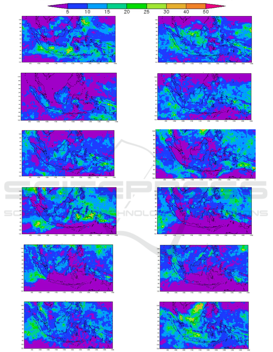
3.3 Rainfall Intensity Variation over
Indonesian Sea
Rainfall is one of the weather and climate elements
that have a dominant influence in the tropics such as
Indonesia, compared to other elements. Therefore,
understanding the characteristics of rainfall, both its
variability and extreme conditions is very important
to recognize the characteristics in order to support
human activities (Harijono, S. W. B., dan Junaeni, I.,
2008), including assisting shipping activities.
Lutfiana and Tirono (2013) further studies show
that rainfall has a significant influence in determining
the safety levels of shipping activities along Surabaya
- Makassar shipping lane.
The area where the rainfall intensity is quite high
is located around Java Sea and some part of Pacific
Ocean in January with a value around 10 – 40
mm/day, while in February the highest rainfall
intensity region was around the small part of the
South China Sea with a value around 15 – 30 mm/day.
Based on categorization made by Indonesian Agency
of Meteorology Climatology and Geophysics, this
categorized as moderate rain, however, until now
there is no particular rainfall categorization (impact-
based forecast) for each type of marine transportation.
Therefore, we assume that moderate rain can cause a
hazard for the barge to sail.
In the next months of the first transition period
(MAM), rainfall intensity over Indonesian sea was
quite lower than the intensity overland region. In
March 2013, rainfall intensity in all parts of
Indonesian sea ranges from 5 – 15 mm/day. While it
starts to slightly increase April and May. In
Australian monsoon period, rainfall intensity tends to
be slightly higher over marine regions than land areas.
Its distribution was varied and random, but it starts to
significantly decrease in August, especially in the
south part of Indonesia. This condition persists until
couple of months later. Rainfall intensity on the south
part of Indonesia, both marine and land areas,
significantly decrease in the second transition period,
except in November. Rainfall intensity increases
significantly in December 2013, especially on the
north part of Indonesian seas such as South China
Sea, Java Sea, and some part of Indian Ocean near
Sumatra islands.
3.4 Atmospheric – Ocean Parameter
Risk Index Variation
Three atmospheric–ocean parameters have been
evaluated and quantified based on Table 4 in order to
get the risk index of sailing safety over the Indonesian
sea (Table 5). This total index can be used as a
reference for the government, especially the Ministry
of Transportation, to assess the safest sea lanes and
inform the public. When the total index reaches a
value between 1 and 3, then a barge has a low-risk
level to sail over the Indonesian sea, in other words,
it is safe for a barge to sail over a marine region that
possesses the index value within the range. While if
the total index value ranges from 4–6, the risk level is
said to be moderate, it means that a barge must be
vigilant during sailing over this region. If the total
index value ranges from 7–9, the risk level is said to
be high for a barge to sail. It is recommended for a
senta 2019 - The International Conference on Marine Technology (SENTA)
24
(a) Januar
y
(b) Februar
y
(
c
)
March
(
d
)
A
p
ril
(e) Ma
y
(f) June
(g)
Jul
y
(
h
)
Au
g
ust
(i) Septembe
r
(j) Octobe
r
(
k
)
Novembe
r
(
l
)
Decembe
r
Figure 2: Month to month variation wave height in meter over Indonesian sea region in 2013.
Mapping Atmospheric: Ocean Parameter Risk Index based on Meteorological Review to Support the Operational Work of Sea Toll Road
Program
25

barge not to sail over these sea lanes. Meanwhile, if
the total index value reaches up to 10 – 12, the risk
level is said to be very high, which means it is really
dangerous for a barge to sail over the region. But
figure 4 shows that the conditions where the risk level
is categorized very high rarely happen over closed sea
waters regions over Indonesia in normal years.
Therefore, it assumes that this condition can occur
when a cyclone or other atmospheric–ocean
disturbance phenomenon happened.
Based on the risk index variation map in January
(Figure 4a), the risk level is very high over the South
China Sea and some parts of Pacific and Indian Ocean
near Sumatra and the south part of Java Island. The
high-risk level region occurred around Java Sea, a
small fraction of Banda, Arafura, and Timor Sea.
While moderate-risk level region mostly occurred
over Karimata Strait. The lowest risk level region was
located around Makassar Strait, Molucca Sea, and the
northern part of Banda Sea. This low-risk level region
is commonly located over small sections of closed sea
waters between some islands surround it as a great
barrier and obstacle when the wind blows over it.
In February, the risk shipping level over the
Indonesian sea was mostly moderate, such as over
Karimata Strait, Java Sea, Banda Sea, Arafura Sea,
and Celebes Sea. The other region among closed
seawater regions over Indonesia possesses a lower
risk level, such as along some parts of Makassar Strait
and some part of Molucca Sea. While, since it is in
the Asian monsoon period, the risk level over South
China Sea and along the Pacific Ocean is categorized
as very dangerous. The atmospheric–ocean parameter
risk level variability tends to get lower in March, low-
risk level region expands over several regions,
including Karimata Strait, a small fraction of Java
Sea, Makassar Strait, and Molucca Sea. While the rest
areas possess a moderate risk level of sailing. In
April, the lower risk level region tends to get wider
and covers almost all part of closed sea waters in
Indonesia. The high-level risk region starts to occur
over Indian Ocean, it moves from Pacific Sea in DJF
period to Indian Ocean as it is approaching JJA
period. In the last month of the first transition phase
period of MAM, the atmospheric–ocean parameter
risk index over the southern part of Indonesian sea
start to increase significantly, especially over Indian
Ocean near Australia.
In Australian monsoon period in June, the
atmospheric–ocean parameter risk level elevated,
especially over Arafura, Banda, and Timor Sea along
with the strengthening of the Australian Monsoon.
This high-risk level region then expands and reaches
its maximum in July 2013 and starts to slightly
decrease in August. In the second transition period in
September, the atmospheric–ocean parameter risk
level generally moderate over all parts of Indonesian
sea, except in a small fraction of Celebes Sea,
Makassar Strait, and Molucca Sea. In October, the
lower risk level region starts to get wider and covers
almost all parts of the Indonesian sea. While, both
Pacific and Indian Oceans possess moderate to high-
risk levels. In the last month of SON period,
November, the low-risk level region became wider
and covered all parts of the closed seawater in
Indonesia. This condition changed significantly in
December when the Asian monsoon began to be
strengthened. The high-risk level region observes
over the dominant part of South China Sea and along
the Pacific Ocean. Karimata Strait and Java Sea
possess moderate risk level of sailing safety, while the
other generally tend to have the low-risk level of
sailing safety.
4 SUMMARY AND CONCLUSION
The wind speed over Indonesia has a distinctive
pattern where the strongest wind region is commonly
located near the ocean, both in Pacific and Indian
ocean, while it starts to decrease as it approaches the
Indonesia sea region, closed waters between the
islands. The significant wave height pattern generally
follows the surface wind pattern as it is the wave
generator factor in the free ocean. Generally, the
characteristics of waves in Indonesian sea waters
have patterns associated with the monsoonal wind
cycle. In Asian monsoon period (DJF), wind speed
generally, starts to increase in December and gets
stronger in January but then tends to weaken in
February. January possesses the strongest wind
distributed around South China Sea and Pacific
Ocean with velocity ranges from 13 up to more than
17 knots.
Compared to wind profile and wave height
variation, rainfall intensity pattern possesses a higher
variability, both in land and marine region. In Asian
monsoon period, the rainfall intensity reaches its
maximum in December 2013 with heavy rainfall
areas distributed around the South China Sea and Java
Sea region with range values from 20–50 mm/day. It
starts to decrease in January, more often significant in
February. In transition periods, rainfall intensity tends
to have a higher value over land area rather than over
marine region. In Australian monsoon period, rainfall
intensity tends to be slightly higher over marine
regions than land areas. Its distribution was varied
and random, but it started to significantly decrease in
senta 2019 - The International Conference on Marine Technology (SENTA)
26
(
a
)
Januar
y
(
b
)
Februar
y
(c) March (d) April
(
e
)
Ma
y
(
f
)
June
(g) Jul
y
(h) August
(
i
)
Se
p
tembe
r
(j)
Octobe
r
(k) Novembe
r
(l) Decembe
r
Fi
g
ure 3: Rainfall intensit
y
(
mm/da
y)
variabilit
y
over Indonesian sea from month to month in 2013.
Mapping Atmospheric: Ocean Parameter Risk Index based on Meteorological Review to Support the Operational Work of Sea Toll Road
Program
27

August, especially in the south part of Indonesia. This
condition persists until a couple of months later.
Rainfall intensity on the south part of Indonesia, both
marine and land areas, significantly decreased in the
second transition period, except in November.
Rainfall intensity increased significantly in
December, the beginning period of Asian monsoon,
especially on the north part of Indonesian seas such
as South China Sea, Java Sea, and some part of Indian
Ocean near Sumatra Island.
As summarised in Table 6, the atmospheric–ocean
parameter risk index map shows that in the active
monsoon period, the closed seawater over Indonesia
generally tends to possess a higher risk level of
sailing. In Asian monsoon, the marine area that
possesses moderate – high-risk levels commonly
located on the northern part of Indonesian seas, such
as South China Sea and Java Sea. While in the
Australian monsoon period, the marine areas that
possess moderate to the high-risk level generally
observe on the southern part of Indonesian seas, such
as over Banda Sea, Arafura, and Timor Sea. Several
marine areas in Indonesia possess low – moderate risk
levels of sailing throughout the normal year, such as
Makassar Strait, Molucca, and Celebes Sea. For
further research, this atmospheric-ocean parameter
risk index can be improved to gain variations of the
results by using a longer time series of data under the
consideration of another climate phenomenon, such
as El Nino and La Nina. Enhancing collaboration
between agencies is also required to support this
project and to obtain some feedback from many
stakeholders.
ACKNOWLEDGEMENTS
We acknowledge National Aeronautics and Space
Administration (NASA) and PPS, which develop and
compute TRMM file data and also European Centre
for Medium-Range Weather Forecasts for reanalysis
wind data. Finally, Geospatial Information Agency of
Indonesia for providing WaveWatch III model data.
REFERENCES
Badan Meteorologi Klimatologi dan Geofisika. (2010).
Extreme weather and climate condition in 2010 – 2011,
press release 12 Oktober 2010, Jakarta.
Bowman, K.P. (2005). Comparison of TRMM Precipitation
Retrievals with Rain Gauge Data from Ocean Buoys. J.
of Climate, Vol. 18, pp. 178-190.
Cooper, K., Dasgupta, A., Kennedy, K., Koelbel, C.,
Mandal, A., Marin, G., Mazina, M., Mellor- Crummey,
J., Berman, F., Casanova, H. and Chien, A., 2004,
April. New grid scheduling and rescheduling methods
in the GrADS project. In 18th International Parallel and
Distributed Processing Symposium. (2004).
Proceedings. (p. 199). IEEE.
Harijono, S. W. B., & Juaeni, I. (2008). Dampak Variasi
Temperatur Samudera Pasifik dan Hindia Ekuatorial
Terhadap Curah Hujan di Indonesia, Jurnal Sains
Dirgantara, Vol. 5 (2), pp. 83-95.
Hutabarat, S. and Evans S. M. (2008). Pengantar
Oseanografi, Jakarta: UI-Press.
Kadarisman, M., Yuliantini, Y. and Majid, S.A. (2016).
Formulasi kebijakan sistem transportasi laut. Jurnal
Manajemen Transportasi & Logistik, Vol. 3 (2), pp.
161-183.
Kisnarti, E.A., (2012). Kajian meteo-oseanografi untuk
operasional pelayaran Gresik-Bawean.
https://dspace.hangtuah.ac.id/xmlui/handle/1234567
89/139.
Kurniawan, R., Habibie, M. N., Permana, D.S. (2012).
Study of High Wave Prone Areas in Indonesian Sea
Region, Jurnal Meteorologi dan Geofisika, Vol. 13 (3),
pp. 201 – 212.
Lasabuda, R. (2013). Pembangunan wilayah pesisir dan
lautan dalam perspektif Negara Kepulauan Republik
Indonesia. Jurnal Ilmiah Platax, Vol. 1 (2), pp. 92-101.
Lutfiana, R. and Tirono, M. (2013). Introduction of maritime
weather patterns (rainfall, wave height, and current
velocity) with the Adaptive Neuro Fuzzy Inference
System (ANFIS) method on the sea lanes along Surabaya
- Makassar, Jurnal Neutrino, Vol. 6 No. 1.
Table 6: Summary of Indonesia’s atmospheric-ocean risk index.
Rank Marine Region Risk Value Month
1 Indian Ocean to the Southwest of Java 10 July
2 Indian Ocean to the South of Java 9 Au
g
ust
3 Arafura Sea 8 June
4 Banda Sea 7 Au
g
ust
5 Indian Ocean to the Southwest of Java 6 Novembe
r
6 Western Indian Ocean of Sumatera 5 March
7 Seram Sea 4 Februar
y
8 Maluku Sea 3 Februar
y
9 Indian Ocean to the East of Kupang 2 Februar
y
10 Makassa
r
Strait 1 Ma
y
senta 2019 - The International Conference on Marine Technology (SENTA)
28

Pranowo, W.S., T.R. Adi, S. Makarim, and N.N. Hasanah.
(2012). Marine & Climate Research Contributions to
the National Program on Climate Change Adaptation &
Mitigation. Proceed. The International Workshop on
Climate Information Services in Supporting Mitigation
& Adaptation to Climate Change in Transportation &
Tourism. 15-16 May 2012. ISBN: 978-602-19508-3-8.
p.76-79.
Rahman, H., Satria, A., Iskandar, B. H., Soeboer, D. A.
(2017). Determination of Dominant Factors Cause
Accidents in the Main Kesyahbandaran of Tanjung
Priok, Albacore. vol. 1 (3), pp. 277 – 284.
Schumacher, C and Houze, R A. (2000). Comparison of
Radar Data from the TRMM Satellite and Kwajalein
Oceanic Validation Site. J. of Applied Meteorology, vol
39, pp. 2151 – 2164.
Shaira, H., Naik, P.R., Pracheth, R., Nirgude, A.S., Nandy,
S., Hiba, M.M. and Karthika, S. (2020).
Epidemiological profile and mapping geographical
distribution of road traffic accidents reported to a
tertiary care hospital, Mangaluru using quantum
geographic information system (QGIS). Journal of
family medicine and primary care, Vol. 9 (7), p.3652.
Simorangkir, E. (2017). Pembangunan Infrastruktur Genjot
Kinerja Industri Pelayaran [online],
https://finance.detik.com/infrastruktur/d-
3736632/pembangunan-infrastruktur-genjot-kinerja-
industri-pelayaran (accessed on 7 August 2019).
Suratno. (1997). Numerical models for estimating sea level
waves for Indonesian sea region and its surroundings.
Tesis, Program studi Fisika, Fakultas MIPA,
Universitas Indonesia, Jakarta.
Wara, A. D. (2019). Coastal Protection, International
Journal of Offshore and Costal Engineering, vol. 1 (1).
Wicaksana, S., Sofian, I., dan Pranowo, W. Karakteristik
gelombang signifikan di Selat Karimata dan Laut Jawa
berdasarkan rerata angin 9 tahunan (2005- 2013).
(2015). Omni-Akuatika, [S.l.], Vol. 11 (2).
World Meteorological Organization (WMO). (1998). Guide
to wave forecasting and analysis, WMO No. 702,
Secretariat of the World Meteorological Organization,
Geneva-Switzerland: Author.
World Meteorological Organization (WMO). (2001). Guide
to marine meteorological services, WMO No. 2.
Secretariat of the World Meteorological Organization,
Geneva-Switzerland: Author.
Mapping Atmospheric: Ocean Parameter Risk Index based on Meteorological Review to Support the Operational Work of Sea Toll Road
Program
29
