
Deep-seawater Oceanographic Survey:
An Experience in Facing Challenges and Opportunities
Sholihin
1,a
, Mukhtasor
1,b
, Abdullah Ammar
2,c
, Sony Junianto
1,d
, Muchammad Iqbal Havis
3,e
1
Ocean Engineering Department, Institut Teknologi Sepuluh Nopember, Indonesia
2
PT Permata Tera Daya, Surabaya, East Java, Indonesia
3
PT ITS Kemitraan, Surabaya, East Java, Indonesia
c
abdoellahammar@gmail.com,
d
sony09@mhs.oe.its.ac.id,
e
muchammadiqbalhavis@ymail.com
Keywords: ADP/ADCP Method, Deep-Sea Survey, Survey Challenges, Survey Opportunities.
Abstract: Onshore and offshore structure planning requires wave and current data which are the result of direct
measurements on site. One area that affects the measurements is the deep-sea, where the area has large wave
energy and currents that greatly affect the condition of the waters adjacent to the location of planned coastal
and offshore structures. One of the most widely used survey equipment is ADP or ADCP. This paper explains
the experiences of collecting oceanography data in deep-sea. The survey method entails placing an equipment
on the seabed, which will emit signals indicating the flow and wave data according to the desired time and
depth. The survey process, especially for the deep-sea, requires good preparation so as not to fail. The result
of this paper is the identification of the technical, natural and social challenges of such project. The technical
challenges are tool stability, buoyancy effects, and visualization tools with underwater camera system,
underwater visibility, and sedimentation. Natural challenges are big waves, strong currents, and weather. The
social challenges are destruction of property, fishing grounds on land, and the behaviour of local people.
Therefore, before the survey, safety procedures and documents must be made in the form of HIRA (Hazard
Identification and Risk Analysis). The authors hope that the challenges identified in this survey can be
considered for other surveyors conducting similar projects in mitigating potential failures during the survey.
1 INTRODUCTION
The vast oceans of Indonesia have a huge potential to
meet the wide range of human needs. Indonesia's
maritime potential takes shape in various forms such
as ocean currents, tidal waves, and others. Sea current
is the water mass movement towards equilibrium
which causes horizontal and vertical displacement of
water masses. The movement is the result of several
acting forces and factors that influence it.
An ocean current is the mass movement of sea
water from one place to another, either vertically
(upward motion) or horizontally (sideways
movement).
According to Gross and Gross (1996), a current
may be caused by wind movement, movement of
thermohaline, tide flow, turbulence, tsunami, and
another wave. Another potential for wave source is
the tidal wave. These environmental conditions may
be used to classify a potential site, for example to
mark a potential location for a tidal wave-basd power
plant (Junianto et al., 2020).
According to Xie et al. (2019), tidal wave is a
phenomenon in which sea water rises and falls
periodically caused by a combination of Earth’s
gravity and the gravitational pull of astronomical
objects, primarily the Sun, Earth and moon. The
influence of other celestial bodies is negligible due to
greater or lesser distances. Under such circumstances,
ocean waves play a very big role in the potential TSB.
Research on waves and ocean currents has been
widely implemented in Indonesia to determine its
potential. Oceanographic surveys mostly use
Acoustic Doppler Current Profiler (ADCP)
(Sindlinger et al., 2005; Guerrero et al., 2014;
Bouferrouk et al., 2016; Latosinski et al., 2017;
Huang, 2018; Santos et al., 2020; Scherelis et al.,
2020; Yin et al., 2020). The equipment is mostly
placed under a vessel to measure ocean current
conditions, for example at a depth of 35.94 to 50.94
Sholihin, ., Mukhtasor, ., Ammar, A., Junianto, S. and Havis, M.
Deep-seawater Oceanographic Survey: An Experience in Facing Challenges and Opportunities.
DOI: 10.5220/0010855900003261
In Proceedings of the 4th International Conference on Marine Technology (senta 2019) - Transforming Maritime Technology for Fair and Sustainable Development in the Era of Industrial
Revolution 4.0, pages 173-177
ISBN: 978-989-758-557-9; ISSN: 2795-4579
Copyright
c
2022 by SCITEPRESS – Science and Technology Publications, Lda. All rights reserved
173
m, obtaining an average speed of 40.51 cm/ sec with
a south westerly direction.
ADCP is one of the main tools used to determine
the value of the speed and direction of ocean currents
of a body of water. Its use is already very helpful for
human needs in various depths. Oceanographic
surveys are rarely carried out in the deep-sea, so
information on constraints and opportunities is rarely
found in references. Considering the remarkable
potentials of deep-sea waters, this paper will thus be
discussing:
1. The identification of challenges of deep-sea
oceanographic marine survey in Indonesia.
2. The opportunity to develop deep-sea surveys.
2 POTENTIALS OF DEEP- SEA
SURVEY
Deep-sea has biological and physical characters of
not letting sunlight penetrate through after a certain
depth. This condition forces the ecosystem in there to
adapt to it as well as to different physical condition in
general environment. By having several
characteristics, such as low temperature, stable, clear,
not pathogenic, containing nutrients, minerals such as
magnesium (Mg), calcium (Ca), potassium (K) as
well as other minerals in large quantities, deep-sea
holds a great potential for exploration.
Usage of Deep-sea Water (DSW) is not limited
only to matters relating to fisheries, but also for other
things such as industrial purposes, and even health
and environmental rehabilitation (Shane, 2015). The
potentials of the deep-sea comes from very rich
chemical contents and excellent physical conditions.
In a hydro-oceanographic survey work, there are
various activities performed as bathymetry survey
(mapping the shape of the seabed), measurements of
ocean currents, ocean tidal measurement,
measurement control nets (benchmarking), sampling
of seawater and seabed sediments, and others. Hydro-
Oceanographic surveys usually done in vary of jobs
in coastal areas or offshore. Due to the varying
parameters of deep-sea measurements, various tools
have to be employed to collect these data. Required
tools include:
1. Bathymetry: Single Beam Echo Sounder (SBES)
or Multi Beam Echo Sounder (MBES),
2. Ocean currents: Current Meter (CM) or Acoustic
Doppler Current Profiler (ADCP),
3. Tides: palm of tidal / Tide Staff or Tide Gauge,
and
4. Ocean waves: Automatic Water Level Recorder
(AWLR) or Wave Recorder, etc.
In deep-sea surveys, one of the main types used
are ADP NORTEK AWAC 400 kHz (Figure 1).
AWAC withstands water pressure up to a depth of
100 m, has an accuracy capability of up to 1.5 Hz
pulse wave, and is able to measure current speed and
direction. The specifications are explained in Table 1.
A survey in East Java began from a depth of 35 m
below the sea surface. With the depth of at least 35m,
we classify the challenges of deep-sea survey using a
case study in eastern Java's survey into several parts.
Figure 1: Nortek AWAC 400 KHz.
Table 1. Technical specifications of NORTEK AWAC -
400 kHz.
Water velocit
y
measurements
Maximum
p
rofilin
g
100
m
ran
g
e
Cell size 1.0-8.0
m
Number of cells
T
yp
ical 20-40,
max. 128
Velocity range
±10 m/s
horizontal, ±5 m/s alon
g
b
ea
m
Accuracy
±1% of measure
d
value ±0.5 cm/s
Maximum out
p
ut rate 1 Hz
Internal sampling rate 2 Hz
Wave measurement o
p
tion (AST)
Maximum depth 100
m
Data types
Pressure, one
velocit
y
alon
g
each
b
eam, AST
Sampling
(output) rate
Velocity
0.75 Hz
AST
1.5 Hz
No. of sam
p
les
p
er burst 512, 1024 o
r
2048
senta 2019 - The International Conference on Marine Technology (SENTA)
174

2.1 Technical Obstacles
Deep-sea marine survey is strongly influenced by the
uncertain natural conditions. Therefore, preparation
and monitoring are important to obtain a good
measurement output. Some technical barriers are
caused by stability of the ship, which may allow for
less measuring equipment to be installed onboard to
maintain its stability.
Figure 2: 30 GT Vessel is suitable for deep-sea survey.
3 CHALLENGES OF DEEP- SEA
SURVEY
Deep-sea water surveys introduce more challenges
than shallow water surveys. Waves are the main
factor taken into account because it will introduce
forces against coastal structures. The calculation of
the planned structure takes into account wave
classification according to the relative depth, which is
the ratio between the water depth d and the
wavelength L so that it becomes
𝑑
𝐿
. The ocean
wave is formulated in Equation (1) as follows:
𝐿
1
𝑑
(1)
Where:
d : depth
L : wave period
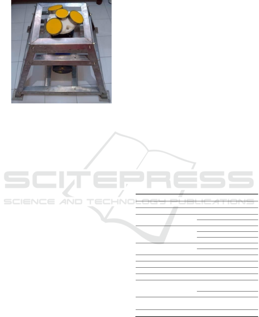
Figure 3: web frame of ADP construction.
In the case of East Java study, the survey vessel
used was a vessel of about 30 GT (Figure 2). The ship
was originally a fishing vessel equipped with a pulley,
which was used to roll the rope to lift up the
instruments. The instruments on the ship were not
stable because the wave height exceeded 2 meters.
Therefore, the ADP instrument had to be framed to
stabilize it when it was lowered to a water depth of
150 m. ADP web frame (Figure 3) was useful to
provide additional weight effect and increased
stability to maintain the position of ADP on sea floor
against external forces.
Another technical obstacle of using ADCP for
deep-sea water survey was the poor underwater
visibility beginning at 150 m depth. Ideally, the use
of ROV would be preferred to monitor the equipment.
However, the cost of deploying an ROV is very
expensive. Instead of using ROV, monitoring was
carried out using a MK-I deep-sea Underwater
Camera System (Figure 4) to monitor ADP at a depth
of 150m. MK-I had a much lower operational cost
compared to the ROV.
Figure 4: Visualization of MK I Deep-Sea Underwate
r
Camera System.
3.1 Nature Challenge
The seabed had a calmer condition than the surface.
However, predictions of current speed and direction
(Figure 5) in the bottom area were a challenge that
must be handled at the time of the survey.
Deep-seawater Oceanographic Survey: An Experience in Facing Challenges and Opportunities
175
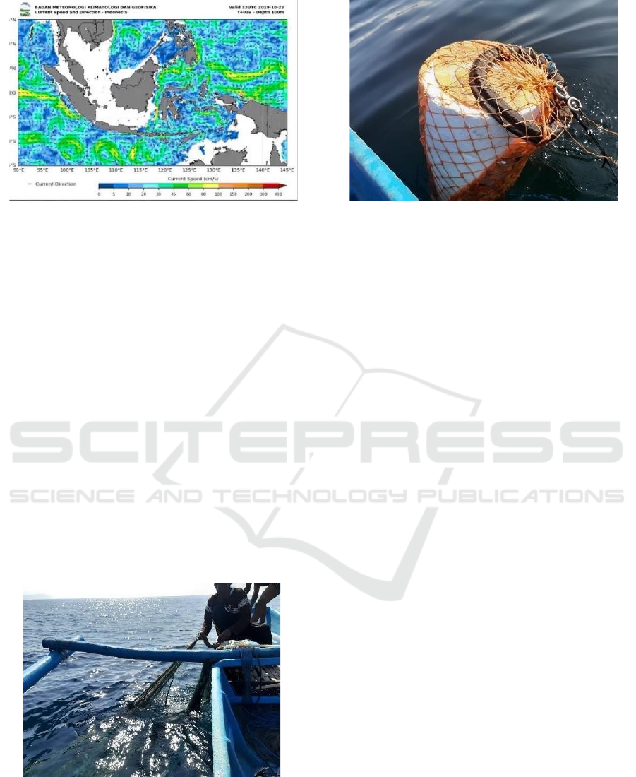
Figure 5: Current velocity and direction prediction at 100m
at the time of ADP monitoring (Junianto et al., 2020).
The challenges did not include only current speed
and direction, but also the water temperature.
Therefore, it was necessary to ensure various safety
requirements were met for this survey.
3.2 Social Challenges
The deep-survey was done in the offshore area far
from the coastal area. Despite the remoteness of the
location, vandalism still occurred. The deployed
survey equipment was not attended and therefore was
lost because of sabotage. (Figure 6). This highlights
the need for surveys to have good security. The
marker buoy should not be put on the water surface.
The society around the oceanographic survey site
always determines the purpose of the survey activity.
They ensure no losses on equipment occur to the
surrounding site. Therefore, it is important to
approach local societies before the survey.
Figure 6: Sabotaged Buoy of ADCP.
Figure 7: Fishing Net Disturbing The Buoy of ADCP.
In addition, the survey marker buoy was caught in
fishing nets in the sea (Figure 7). This can interfere
with the data retrieval process by ADCP. The
placement of equipment at the survey location should
also consider the fishermen's activities around that
location.
4 DISCUSSIONS
The safety of personnel and equipment is paramount to
the sustainability of the survey. In order to prevent risk
to personnel and instruments, hazard and risk
identification is necessary. This process is necessary to
anticipate the risks that may hinder the activities of the
survey. Table 2 shows a list identifying hazards that
could potentially occur in the survey.
The explanation of activity during the survey in
the deep-sea area in previous section shows that the
risk of this survey is relatively large. Therefore, these
risks cannot be ignored during the planning stage for
deep-sea surveys. The reports during this survey,
especially in the technical and social aspects, can then
be used for future surveys.
Health and safety (K3) as a whole means that all
workers involved in a field project are entitled to
health and safety services regardless of the status of
sector (formal/informal), company size, and type of
work. Both the development and growth of the
industrial sector are always accompanied by a huge
problem of workplace accidents and occupational
diseases (Scherelis et al., 2020).
5 CONCLUSION
A successful deep-sea survey can be performed after
considering several aspects. These aspects include
senta 2019 - The International Conference on Marine Technology (SENTA)
176

environmental, technical and social factors. This
paper has presented activity in every aspect during a
deep-sea survey. The paper may serve as a reference
in the future to mitigate potential risks in carrying out
deep-sea surveys.
Deep-sea surveys may have more complex
environmental conditions, especially in sea level
conditions where breaking waves do not occur. The
survey equipment must be more advanced and tested
for its strength so that data security, safety and quality
are guaranteed. Another concern in this activity is the
social interactions which may cause deployed
equipment to be stolen or damaged.
REFERENCES
Bambang Triatmodjo, 1999. Teknik Pantai, Beta Offset,
Yogyakarta (in Bahasa).
Bouferrouk, A., Saulnier, J.B., Smith, S.H., Johanning, L.,
2016. Field measurement of surface waves using a 5-
beam ADCP. Ocean Engineering, 112, 173-184.
Gross, M. and Gross, E., 1996. Oceanography - A View of
Earth 7th Edition. Upper Saddle River, New Jersey:
Prentice Hall.
Guerrero, M., Tuther, N., Archetti, R., 2014. Comparison
under controlled conditions between multi-frequency
ADCPs and LISST-SL for investigating suspended
sand in rivers. Flow Measurement and Instrumentation,
37, 73-82.
Huang, H., 2018. A modified Simpson model for estimating
random uncertainty of moving-boat ADCP streamflow
measurements. Flow Measurement and
Instrumentation, 61, 84-93.
Junianto, S., Mukhtasor, Prastianto, R.W., Wardhana, W.,
2020. Motion responses analysis for tidal current
energy platform: Quad-spar and Catamaran types.
China Ocean Engineering, 5, 677-687.
Latosinski, F.G., Szupiany, R.N., Guerrero, M., Amsler,
M.L., Vionnet, C., 2017. The ADCP’s bottom track
capability for bedload prediction: Evidence on method
reliability from sandy river applications. Flow
Measurement and Instrumentation, 54, 124-135.
Santos, A.I., Oliveira, A., Carinhas, D., Pinto, J.P., Nuno,
Z., Freitas, M.C., 2020. The acoustic properties of in-
situ measured suspended sediments and their
implications on concurrent ADCP response- Case
studies of the Portuguese inner shelf. Marine Geology,
419, 106079.
Scherelis, C., Penesis, I., Hemer, M.A., Cossu, R., Wright,
J.T., 2020. Dataset for concurrent echosounder and
ADCP measurements at a tidal energy candidates site
in Australia. Data in Brief, 31, 105873.
Sindlinger, L.R., Biggs, D.C., DiMarco, S.F., 2005.
Temporal and spatial variability of ADCP backscatter
on a continental slope. Continental Shelf Research, 25,
259-275.
Xie, C., Li, M., Wang, H., Dong., 2019. A survey on visual
analysis of ocean data. Visual Informatics, 3, 113-128.
Yin, Y., Liu, Z., Hu, P., Hou, Y., Lu, J., He, Y, 2020. Impact
of mesoscale eddies on the southwestward counter
current northeast of Taiwan revealed by ADCP
mooring observations. Continental Shelf Research,
195, 1040.
Table 2. Hazard Identification and Risk Analysis.
No Hazard Risk Miti
g
ation
Mobilization/Demobilization
1
Instruments
stolen
Instruments
lost
Attaching keys and
securit
y
cove
r
Guarding during
travel
2
Instruments
shaken
Broken
instruments
Packing with safety
tool box and selecting
a suitable vehicle
Instruments Deployment
1
Over-
capacity
b
oat
The boat
sinks
Using qualified boat
2
Broken rope
while
installing
instrument
Instruments
lost
Usin
g
certified ro
p
e
Hiring qualifie
d
winch operator
3
Flipped
Bad
measured
data
Using
b
allast and
anchor, develop stable
frame, deploy in weak
current period, visual
check with underwater
camera
Data Recording
1
Insufficient
power
Bad/lost
measured
data
Use new battery
2 Vandalis
m
Buoy/
marker lost
Monitoring
periodically, using
sling wire attached on
buoy, and 24-hour
g
uardin
g
3 Hit by other
object
Instruments
flipped
24-hou
r
g
uardin
g
Two 24 hour stan
d
by
g
uardin
g
b
oat
Data Acquisition
1
Broken rope
when lifting
the
instrument
Instrument
lost
Using certified rope,
and hiring qualified
winch operator
2
Download
failure
Incomplete
data
Using require
d
b
attery
set, using high grade
data cable, and avoid
hard impact
Social Issues
1
Vandalism
and
deliberate
damaging
Equipment
removed
from survey
site
Approaching local
leader and local
people around the
survey site, and
submitting notification
and permit to the
Marines, Headman
and DKP
Deep-seawater Oceanographic Survey: An Experience in Facing Challenges and Opportunities
177
