
Near Miss Analysis of Marine Traffic in Sunda Strait Indonesia
Fadilla Indrayuni Prastyasari
1,3,a
, Takeshi Shinoda
2
1
Department of Urban and Environmental Engineering, Graduate School of Engineering, Kyushu University, Japan
2
Department of Marine Systems Engineering, Faculty of Engineering, Kyushu University, Japan
3
Department of Marine Engineering, Faculty of Marine Technology, Institut Teknologi Sepuluh Nopember, Indonesia
Keywords: AIS Data, Collision Accident, Near Miss, Probability, Sunda Strait.
Abstract: A near miss condition is an occurrence that does not result in any injury, loss, or damage but has a potential
to do so. In the field of safety management as shown by the Heinrich’s pyramid that behind one occurrence
of accident, there are at least 300 near miss incidents behind it. This marks the importance of near miss
analysis to prevent the future accident. This paper evaluates the near miss condition in Sunda Strait vicinity
by analysing the AIS data of that particular area. Sunda Strait is the primary route that serves two major
shipping lanes; the Archipelagic Sea Lanes (ASL) I and the crossing lane from Merak to Bakauheni for
passenger ferries. The near miss events considered are between a passing vessel and a crossing vessel or
between two passing vessels. A one-week AIS data of Sunda Strait is utilised to conduct the analysis. The
result of the analysis shows the probability of the near miss incident to be 7.72E-2. Furthermore, the location
of the near miss condition is also analysed. It is found that the near miss situation mostly happened near the
Merak Port. Crossing situation appeared to be the most frequently situation encountered in this area.
1 INTRODUCTION
Indonesia as an archipelagic country has adopted
three archipelagic sea lanes ASL) to allow the
international ship passing the Indonesia water. One of
the sea lanes is the Indonesia ASL (IASL) I, which
located in the west part of Indonesia passes the Sunda
Strait.Sunda Strait is a water area located in the west
of Java Island and connects it with Sumatera Island.
The traffic here is quite heavy because there are two
main passages, the international passage or the IASL
I, spanning in the north and south bound direction,
passed by the cargo ships going from or to the
Malacca Strait and the other one is a crossing channel,
which in east to west bound direction, used by
passenger ships from the Port of Merak in West of
Java to the Port of Bakauheni in Sumatera.
In response to the above-mentioned situation, the
Government of Indonesia proposed a traffic
separation scheme (TSS) to regulate the traffic in this
vicinity. A new TSS is proposed to the International
Maritime Organization (IMO) due to the high traffic
density in Sunda Strait, as the traffic is expected to
have a continuous increase in the near future
(IMO,2018). This may happen due to the port
facilities improvement and development as it wants to
be the new global transhipment hub as the China’s
maritime Silk Road passes through Indonesia waters.
Another reason is the existence of the Koliot Reefs
that is also considered tobe dangerous for the ships
passing through this strait due to the risk of
grounding.
The passageway of international cargo ships and
passenger ferries in Sunda Strait can cross each other
in the Sunda Strait area. This may result to a
possibility of collision while the number of it should
be reduced or eliminated, if possible. Therefore, it
would create a safe navigation passage not only for
the cargo vessels but also the passenger ferries and
there will be no serious injuries caused by the
collision accident.
In the safety management field, the Heinrich’s
safety triangle is known to be a triangle that can make
a relation between major accidents, minor incidents
and near misses. This triangle was theorized by
Herbert Heinrich in 1930s and states a ratio between
severe injury, minor injury and near miss to be
1:29:300, respectively (Heinrich, 1941). A near miss
condition is an occurrence that does not result in any
injury, loss, or damage but has a potential to do so.
This paper is aimed to give a brief preliminary
description on the near miss incident in Sunda Strait
Prastyasari, F. and Shinoda, T.
Near Miss Analysis of Marine Traffic in Sunda Strait Indonesia.
DOI: 10.5220/0010855600003261
In Proceedings of the 4th International Conference on Marine Technology (senta 2019) - Transforming Maritime Technology for Fair and Sustainable Development in the Era of Industrial
Revolution 4.0, pages 153-159
ISBN: 978-989-758-557-9; ISSN: 2795-4579
Copyright
c
2022 by SCITEPRESS – Science and Technology Publications, Lda. All rights reserved
153
area, as a basic to understand the marine traffic
around this water. The paper is divided into five
sections. Section 2 outlines the current traffic in
Sunda Strait, Section 3 describes about the automatic
identification system (AIS) data used for this
research, Section 4 discusses about the near miss in
the Sunda Strait, and the last, Section 5 gives the
conclusion of the paper.
2 TRAFFIC IN SUNDA STRAIT
Sunda strait is one of the major shipping lanes in
Indonesia. It is located between Java and Sumatera
Island and connects the Java Sea to the Indian Ocean.
This strait has become one of the busiest shipping
channels in Indonesia together with Lombok Strait,
Madura Strait and Malacca Strait. In addition, an
island is also located in the Sunda Strait that is
appointed as a Marine Nature Park named Sangiang
Island. Moreover, there are cluster of coral reefs,
named Koliot Reefs and Gosal Reefs, located in that
strait that may cause a risk of grounding to the ships
passing this area.
2.1 Current Traffic
Two types of ship traffic are navigating in Sunda
Strait. The first one is the ferry passenger ship that
operated between Merak Port in Banten and
Bakauheni Port in Lampung and the other one is
cargo ship coming from the Malacca Strait, Indian
Ocean, or South China Sea. Moreover, several special
ports owned by the industries are located close to the
Merak Port that serves some industrial facilities make
the traffic in this area becomes heavier (Sunaryo,
Priadi, & Tjahjono, 2015). The traffic density in
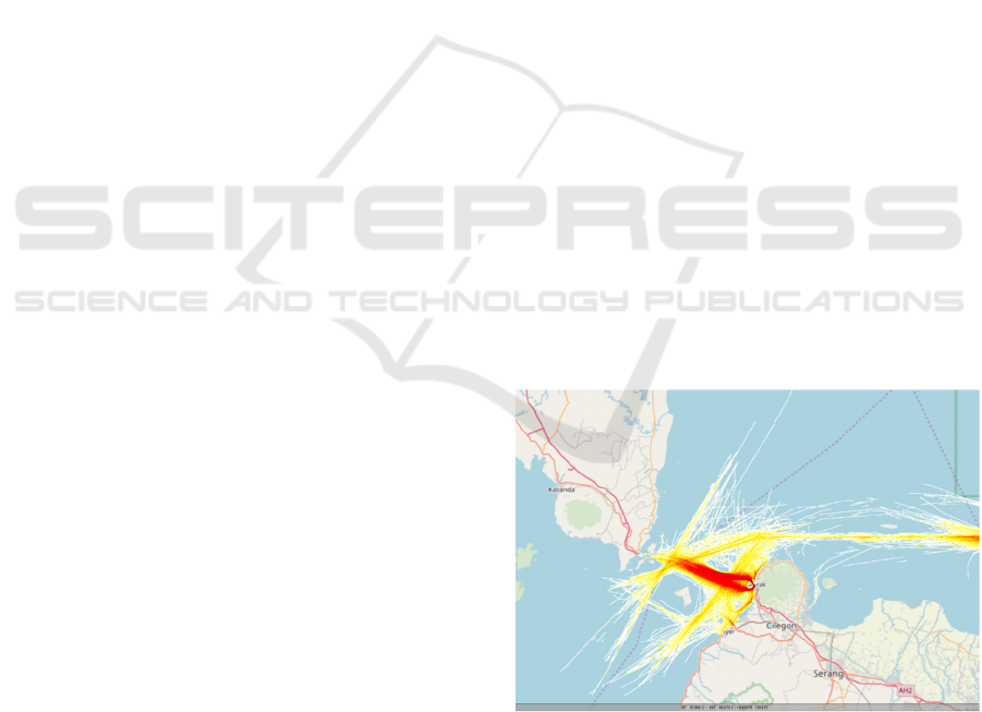
Sunda Strait is shown in Figure 1. The figure shows a
crossing point between the traffic of passenger ship
and the ships passing in IASL I. As shown in that
figure, the traffic here is quite heavy especially in the
route used by the passenger ferries crossing the strait.
The number of passengers commuting through this
strait shown a dramatical increase as depicted by
Figure 2.
Due to the dense marine traffic in Sunda Strait
area, several accidents occurred. One of them is an
accident between a gas tanker Norgas Cathinka, an
Italian flagged ship, that collided with a passenger
ferry named Bahuga Jaya in September 2012. This
was a serious accident as it caused 7 fatalities and a
major loss for both companies. The accident was
caused mainly by human error because the lack of
communication skills of the seafarers (NTSC, 2013).
2.2 Traffic Separation Scheme
Traffic separation scheme is a routeing measure used
to separating two opposing traffic in a certain
waterway by means of traffic lanes and other
appropriate means. It was firstly implemented on the
Dover Straits, the United Kingdom in 1967 and the
number of head-on collisions was found significantly
dropped after this measure had been implemented
(IMO, n.d.). It is outlined in the book of Ships
‘Routeing by the IMO that apart from TSS, there are
numerous numbers of routeing measures, for
example, inshore traffic zone, precautionary area,
two-way route, etc (IMO, 2008).
The implementation of TSS is expected to reduce
the collision frequency in a certain waterway. As
what has been summarized by (Plant, 1985) from the
Ships’ Routeing book that the purpose of TSS can be
shrunken into two, ship to ship collision avoidance
and collision avoidance between ship and static
facilities. Usually, the TSS is set in area with a high
traffic density as implemented in, for example, the
Sunk area in the United Kingdom (IMO, 2006), TSS
in the vicinity of Kattegat (Forsman, 2017), and also
the TSS in Straits of Malacca and Singapore
(Intergovernmental Maritime Consultative
Organization, 1978). The other reason for arranging
TSS is because the area has some environmental
constraints such as in TSS Bay of Fundy in Canada
and TSS Cabo de Gata in Spain that have a concern
to prevent ship from striking the whale as it is
categorized as an endangered species in those water
(Silber et al., 2012).
Figure 1: Heat map of Sunda Strait.
The implementation of TSS is expected to reduce
the collision frequency in a certain waterway. As
what has been summarized by (Plant, 1985) from the
Ships’ Routeing book that the purpose of TSS can be
shrunken into two, ship to ship collision avoidance
senta 2019 - The International Conference on Marine Technology (SENTA)
154

and collision avoidance between ship and static
facilities. Usually, the TSS is set in area with a high
traffic density as implemented in, for example, the
Sunk area in the United Kingdom (IMO, 2006), TSS
in the vicinity of Kattegat (Forsman, 2017), and also
the TSS in Straits of Malacca and Singapore
(Intergovernmental Maritime Consultative
Organization, 1978). The other reason for arranging
TSS is because the area has some environmental
constraints such as in TSS Bay of Fundy in Canada
and TSS Cabo de Gata in Spain that have a concern
to prevent ship from striking the whale as it is
categorized as an endangered species in those water
(Silber et al., 2012).
Traffic separation scheme for Sunda Strait has
been proposed by the Government of Indonesia (GoI)
the Sub-committee on Navigation, Communication
and Search and Rescue (NCSR) of IMO on October
2018, then on the 6
th
NCSR IMO plenary session was
approved and ratified. It also has been adopted by the
IMO in the 101
st
IMO MSC meeting and will come
into force in the June 2020. The background behind
this proposal was not only due to the high traffic
density in the Sunda Strait, but also the existence of
Koliot Reef nearby the shipping lane that the GoI
wants to protect as many grounding incident occurred
around this area.
The implementation of TSS is expected to reduce
the frequency of collision, especially the head-on
collision, and other collision types in general such as
overtaking and crossing collision. The purpose of this
measure is to separate a traffic lane which has two
opposing traffic to have their own lane. Theoretically,
this will push the probability of two ships having
contra direction to meet in a certain point. Hence, the
head-on collision frequency can be reduced. This
statement is in a good agreement with the calculation
done by (Fujii and Shiobara, 1971) that the number of
collision or collision rate for traffic that has a
complete separation is much smaller than the one that
has a complete mixing traffic, assuming that the
density is uniform and the number of vessels coming
and leaving are each equal to the half of the total
traffic.
The efforts made to reduce the number of
collisions by introducing TSS in Sunda Strait is
because there are many near miss situations and
several incidents happened that lead to a low to
serious damage and loss. The near miss situation
becomes the main interest in this paper, because this
situation happens more frequently rather than the real
accident. However, the near miss analysis can be
beneficial because it can give a picture in what way
the accident might happen, so it can be avoided.
3 AIS DATA
3.1 AIS System
Automatic Identification System (AIS) is an
automated ship tracking system that can make
navigational data exchange becomes possible,
between one ship to others or from ship to the shore-
based station. The data that can be stored in the AIS
includes static and dynamic data. Static information
is stored since the initial installation of AIS such as
Maritime Mobile Service Identity (MMSI) number,
IMO number, call sign, ship’s name, etc. While the
dynamic data is the data that keep changing depends
on the ship’s position. Those included in this type of
data are the position (longitude and latitude), course
over ground (COG), speed over ground (SOG),
heading, and so on (IMO, 2003). AIS transponder
shall be installed onboard of all passenger ship, all
ships above 300GT or above and bound for
international voyage and cargo ships of 500GT or
above and not bound for international voyage as
required by the IMO since 31 December 2014 (IMO,
n.d.)
AIS has been widely utilized in the marine sector
because its ability to store a broad range of data,
which is up to 27 message types, for many purposes,
such as, for the tracking system when it combined
with the Inmarsat and satellite for navigation(Yang et
al., 2011), estimating the traffic pattern in a certain
waterway (Chen et al., 2018), (Gunnar Aarsæther and
Moan, 2009), risk assessment and collision avoidance
(Miyake et al., 2015), (Mou et al.,2010) and (Nguyen
et al., 2018), spatial planning (Le Tixerant et
al.,2018), illegal fishing detection (Longépé et al.,
2018) and the last is the use of AIS data for near miss
collision as studied by Goerlandt et al. (2012) and
Zhang et al. (2016).
3.2 Data Collection
This research is utilizing AIS data to see the
manoeuvring process of the ship passing in the
vicinity of Sunda Strait. AIS data for the period of one
year was collected for the purpose of this research
started from 8th of October 2018 until 21stof October
2019. However, a sample of a one-week data started
from 8
th
of October 2018 until 13
th
of October 2018 is
taken and analysed. A one-week data is selected to
make sure that near miss situations are exist in that
area. That period of time is chosen because there are
too many data gaps and that makes analysing the AIS
data continuously becomes difficult. The distribution
Near Miss Analysis of Marine Traffic in Sunda Strait Indonesia
155
of data gap is shown in Figure3.The red area shows
that there is no data recorded in that time
Figure 2: Number of passengers using passenger ferries in
Sunda Strait.
Figure 3: Distribution of AIS data.
There are 132093 of AIS data used for this
paper. The AIS data structure used in this research
consists of:
a. static data: MMSI, ship name, ship callsign,
ship type, GT, DWT, length, depth, beam, draft,
year built, and flag.
b. dynamic data: latitude, longitude, rate of turn,
speed over ground, course over ground,
heading, and timestamp.
3.3 Data Collection
The AIS data that has been collected in the
previous step is then used to get the extracted trip.
This can be done by using a software named IALA
waterway risk assessment program (IWRAP)
developed by International Association of Marine
Aids to Navigation and Lighthouse Authorities
(IALA). IALA is an organization that collect and
provide some information regarding nautical
matters. The IWRAP software is developed to
make the calculation of collision and grounding
collision easier.
The AIS data is then processed to get the traffic
density, heat map,
extract
the route of the ships, as
well as to see the movement of each ship. The
ship’s trips are visually observed to determine
whether they are engaged in a near miss condition
and then the type of encounter is decided. The
analysis is made to know the traffic conditions in
Sunda Strait. Near miss analysis issued to see the
characteristic of a certain water without expecting
a collision to occur. For example, we can predict
the traffic pattern by understanding where the near
misses are likely to occur.
4 NEAR MISS ANALYSIS
The near miss
analysis
is carried out to understand
the characteristic of marine traffic in Sunda Strait.
As it has been previously mentioned that near miss
analysis can help avoiding the real accident by
studying how the ships began to manoeuvre while
they are facing the risk of collision in Sunda Strait
that has a high traffic density.
The analysis of near miss condition in this paper
includes:
a. The probability of near miss situation in the
period of analysis
b. The location which the near miss condition
occurred,
c. The time where most of the near miss situation
occurred.
4.1 Probability of Near Miss
The near miss situation in Sunda Strait is marked by
the movement of the ships that tend to avoid the other
ships by doing such manoeuvres. This research is
utilizing AIS data to see the manoeuvring process of
the ship passing in the vicinity of Sunda Strait. The
frequency of it can be used to predict the number of
minor and major accidents and help to avoid those
conditions by understanding the factors that lead to
the accident.
Figure 4a to 4d show how the ship has
successfully manoeuvred while encountering the
collision risk with two other ships. The blue point
shows the CPA between two ships encountered each
other, the black line is the course over ground line,
while the red line indicates the heading. In Figure 4a,
Cipta Anyer is approaching KMP Bahuga Pratama
and Trimas Kanaya. The heading of Cipta Anyer
slightly changed to avoid the collision course with
both ships and the heading also further changed in
1400986
1347335
1398765
1459120
1652525
1300000
1400000
1500000
1600000
1700000
2010 2011 2012 2013 2014
Passenger crossing Sunda Strait
senta 2019 - The International Conference on Marine Technology (SENTA)
156

Figure 4c. Figure 4d shows that the Cipta Anyer can
safely passed the near miss condition.
Analysis of the near miss frequency is done by
carefully watch or can be said as visually observing
the ship’s movements. The total of 55 near miss
conditions were observed during the designated one-
week period. The traffic during one week of
observation is outlined in the Table 1. The detail of it
is shown in Figure 5. This figure shows three different
types of encounters, head on, overtaking, and
crossing with each type of encounter occurred 4, 2
and 49 times, respectively and shown in Figure 5,
Crossing encounter is found to be the most frequently
happened encounter due to the present traffic in
Sunda Strait is still unregulated due to the TSS has
not been come into force, so there are many ships
cross each other in the waterway. Probability of the
near miss is calculated by using this following
equation.
𝑃
𝑁
𝑉
(1)
Figure 4: Distribution of AIS data.
Where;
N
NM
: number of near miss situation (events)
V : total traffic volume (trips)
Equation 1 yields the probability of near miss
condition in the Sunda Strait during six days started
from 8
th
of October to 13
th
of October 2018 to be
7.72E-2 event per six-day.
4.2 Distance between Ship
IWRAP has utilized the concept of closest point of
approach (CPA). This theory is then used to calculate
the distance of closest point of approach and the time
of closest point of approach. This paper uses the
distance to CPA of two ships to understand how close
the distance between two ships. The Figure6 below is
the graph that shows the distance to the closest point
of approach (DCPA) that is shown by IWRAP. It is
shown that most of them encounter other ships in the
distance of less than 1.3km or approximately 0.7 nm.
The distance between two ships encountering a
collision situation is very close until they made such
a manoeuvre to avoid each other. Hence, it can be
inferred that the decision made by the officer on
watch (OOW) was not made until he believes that the
collision cannot be avoided if he does not make any
effort.
4.3 Time of Near Miss
The near miss situation can happen due to many
factors. Time of day was thought to be one of the
contributions to the near miss situation. It was firstly
considered that the near miss situation is encountered
during the night-time as the traffic of the cargo ships
are denser during this time.
Figure 7 depicts how the time in a day give an
effect to the near miss situation. The available data is
processed to see when the near miss situations are
most likely to occur. The observation came up with
the result that the near miss often occurred during 9
pm to 12am. However, at6am to 9am and 12pm to
3pm, both have the same number of near misses
happened during that time.
Table 1: Traffic volume in Sunda Strait.
Date 8-Oct-18 9-Oct-18 10-Oct-18 11-Oct-18 12-Oct-18 13-Oct-18 Total
Traffic volume 76 90 162 128 184 72 712
(a) (b)
(
c
)
(
d
)
Figure 5: Manouver made by a ship encountering othe
r
ships.
Near Miss Analysis of Marine Traffic in Sunda Strait Indonesia
157
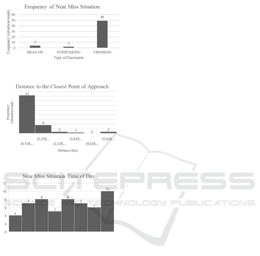
Figure 6: Near Miss Frequency for each type of encounter.
Figure 7: Summary of distance to the CPA.
Figure 8: Near miss frequency for each type of encounters.
5 CONCLUSIONS
A near miss condition is an occurrence that does not
result in any injury, loss, or damage but has a potential
to do so. Near miss collision in. the vicinity of Sunda
Strait is studied in this paper. AIS data is collected for
one year, from 8th of October2018 until 21st of
October 2019. However, only a six-day period is used
in this research to understand the traffic conditions in
this area.
There are three key points of the near miss
condition that become the main focus, those are, the
probability of the near miss, the distance between two
ships in the near miss situation and the time when the
near miss happened. The first one, the probability of
the near miss condition is 7.72E-2 for the duration of
six days. Next, the distance to the closest point of
approach observed between two ships during the time
interval mostly less than 1.3km or 0.7nm. Lastly, the
time when most of the near miss happened is during
9pm to 12am.
The first finding of this research shown that the
crossing situation occurred mostly during a week.
This result has a good agreement with the fact that the
passage of cargo ships which follow the IASLI
crosses the passage of passenger ferries from Merak
to Bakauheni. This situation leads to the development
of the precautionary area, which is the area where the
vessel must navigate with caution to reduce the risk
of, which in this case is, crossing collision
The second result, we found that the vessels which
is in an encountering situation tend to stay on their
speed and course and take a collision avoidance
action when the distance is less than1 nm. This action
shall be taken as early as possible or when one of the
vessels is realizing the risk of collision, to avoid the
vessel involved in a close quarter situation.
The last result corresponds to the near miss
situation that frequently happened during midnight
(21:00–24:00). This can be happened due to low
visibility, misunderstood the ship light with an
inshore light, or other factors. A further study needs
to be conducted in order to understand the factors
involved in the collision accident or near miss in
Sunda Strait.
REFERENCES
Chen, Z., Xue, J., Wu, C., Qin, L., Liu, L., Chen X., 2018.
Classification of vessel motion patter in inland
waterways based on Automat Identification System.
Ocean Engineering 1669-76
https://doi.org/10.1016/j.oceaneng.2018.04.072
Forsman, B., 2017. Sea Traffic and Consequence
Analysand IWRAP Mk2 Analysis Related to Proposal
for New Routeing Measures in the Vicinity of Kattegat
between Denmark and Sweden (NRE20178197-01-00-
B).
Fujii, Y., Shiobara, R., 1971. The Analysis of Traffic
Accidents. J. Navigation 24, 534–
54https://doi.org/10.1017/S0373463300022372
Goerlandt, F., Montewka, J., Lammi, H., Kujala, P.,
201Analysis of Near Collisions in the Gulf o Finland.
Advances in Safety, Reliability and Risk Management–
Bérenguer, Grall & GuedeSoares (eds).
Gunnar Aarsæther, K., Moan, T., 2009. Estimating
Navigation Patterns from AIS. J. Navigation62,587-
607 https://doi.org/10.1017/S0373463309990129
Heinrich, H.W., 1941. Industrial Accident Prevention.
Scientific Approach.
senta 2019 - The International Conference on Marine Technology (SENTA)
158

IMO, 2018. Establishment of a new traffic separation
scheme and associated routeing measures in the Sunda
Strait, Indonesia
IMO (Ed.), 2008. Ships’ routeing, 2008 ed., 9th ed. E
International Maritime Organization, London.
IMO, 2006. New and Amended Existing Traffic Separation
Scheme (No. COLREG.2/ Circ. 58).
IMO, 2003. Guidelines for the Installation of a Ship borne
Automatic Identification System (AIS).
IMO, n.d. Historical Background on Ships’ Routeing
African Development Bank, 2010. African
development report. Ports, logistics, and trade in
Africa. Oxford University Press Inc., New York.
IMO, n.d. AIS transponders. URL
http://www.imo.org/en/OurWork/Safety/Navigation/P
ages/AIS . aspx (accessed 11.27.19b ).
Intergovernmental Maritime Consultative Organization,
1978. Navigation through the Straits of Malacca and
Singapore (No. Resolution A.375(X)).
Le Tixerant, M., Le Guyader, D., Gourmelon, F., Queffelec
,B., 2018. How can Automatic Identification System
(AIS) data be used for maritime spatial planning?
Ocean & Coastal Management 166,18–30 .
https://doi.org/10.1016/j.ocecoaman.2018.05.005
Longépé, N., Hajduch, G., Ardianto, R., Joux, R. de,
Nhunfat, B., Marzuki, M.I., Fablet, R., Hermawan, I.,
Germain, O., Subki, B.A., Farhan,R., Muttaqin, A.D.,
Gaspar, P., 2018. Completing fishing monitoring with
space borne Vessel Detection System (VDS) and
Automatic Identification System (AIS) to assess illegal
fishing in Indonesia. Marine Pollution Bulletin131, 33–
39.https://doi.org/10.1016/j.marpolbul.2017.10.016
Miyake, R., Fukuto, J., Hasegawa, K., 2015.Analyses of the
Collision Avoidance Behaviours Based on AIS Data.
The Journal of Japan Institute of Navigation 133, 66–
74. https://doi.org/10.9749/jin.133.66
Mou, J.M., Tak, C. van der, Ligteringen, H., 2010. Study
on collision avoidance in busy waterways by using AIS
data. Ocean Engineering 37, 483–
490.https://doi.org/10.1016/j.oceaneng.2010.01.012
Nguyen, M., Zhang, S., Wang, X., 2018. A Novel Method
for Risk Assessment and Simulation of Collision
Avoidance for Vessels based on AIS. Algorithms11,
204.https://doi.org/10.3390/a11120204
NTSC, 2013. Investigation Into the Collision Between
Indonesia Registered Ro-ro Passenger Ferry MV
“Bahuga Jaya” and Singapore Registered MT “Norgas
Cathinka” at Sunda Strait (4 Nautical miles east of
Rimau Balak Island), Indonesia (No. KNKT-12-09-03-
03).
Plant, G., 1985. International traffic separation schemes in
the new law of the sea. Marine Policy 9, 134–
147.https://doi.org/10.1016/0308-597X(85)90005-3
Silber, G.K., Vanderlaan, A.S.M., Tejedor Arceredillo , A.,
Johnson, L., Taggart, C.T., Brown, M.W., Bettridge, S.,
Sagarminaga, R., 2012. The role of the International
Maritime Organization in reducing vessel threat to
whales: Process, options, action, and effectiveness.
Marine Policy 36, 1221–
1233.https://doi.org/10.1016/j.marpol.2012.03.008
Yang, C., Hu, Q., Tu, X., Geng, J., 2011. An Integrated
Vessel Tracking System by Using AIS, Inmarsat and
China Beidou Navigation Satellite System, in: Weintrit,
A. (Ed.), Navigational Systems and Simulators. CRC
Press, pp. 43–46.https://doi.org/10.1201/b11343-8
Zhang, W., Goerlandt, F., Kujala, P., Wang, Y., 2016.
Anadvanced method for detecting possible near miss
ship collisions from AIS data. Ocean Engineering124,
141–
156.https://doi.org/10.1016/j.oceaneng.2016.07.059
Near Miss Analysis of Marine Traffic in Sunda Strait Indonesia
159
