
Identification of Coastal Problem along the East Coast of Lampung
Indonesia
Trika Agnestasia Tarigan
1
, Nanda Nurisman
1
and Nirmawana Simarmata
2
1
Department of Ocean Engineering, Institut Teknologi Sumatera, Jalan Terusan Ryacudu, Lampung Selatan, Indonesia
2
Department of Geomatics Engineering, Institut Teknologi Sumatera, Jalan Terusan Ryacudu, Lampung Selatan, Indonesia
Keywords: Coastal Problem, East Coast, South Lampung.
Abstract: The dynamics of nature occurring in recent years, as well as climate change and the increasingly severe
pressures of humans have had a noticeable impact on the coastal conditions. This research aims to present the
results of identification of various damages that occurred along the East Coast of South Lampung Regency of
Lampung Province with the method of field surveys through observation, measurement, study of supporting
data and previous research. This study was conducted with several activities, namely field observation,
interviews and documentation of conditions for damage to coastal areas. The final result of this identification
is to describe: (a) the type of damage occurring; (b) Cause of damage; (c) The impact of any damages incurred;
(d) Alternative countermeasures; and (e) The location coordinates are damaged. The results showed that the
sedimentation process and damage to coastal structures occurred at the location of Ketapang Laut village.
Sedimentation also occurs in the estuary of Ketapang Laut village of South Lampung to cause the presence
of land arises, the sediment of river estuary and the coastline. Another problem is the decrease of mangrove
forest area which is one caused by the opening of the area to be used as shrimp pond.
1 INTRODUCTION
The problem of coastal areas is a condition that inflict
damage to coastal areas caused by natural processes
or caused by human activities. The factors that cause
damage to coastal areas can naturally come from the
influence of the hydro-oceanographic processes
occurring in the sea that can cause waves to wave,
resulting in sedimentary transport, changes in current
patterns, tidal variations, and climate change (Fadilah
et all, 2013).
Some locations along the coast are damaged,
especially in physical forms such as coastal line
changes, either abrasion/erosion and accretion/
sedimentation. East Coast of South Lampung
Province is one of the coastal areas that is not
separated from the general problems of the beach is
erosion and sedimentation. The change of coastline is
a process that lasts continuously through a variety of
processes both erosion (abrasion) and additions
(accretion) resulting from the movement of coastal
sediments, longshore current, wave action and land
use (Arief et. al., 2011).
Coastal erosion is a result of human activities and
natural environment changes making the coastal
dynamic action (wave, current, wind) lose balance in
the coastal process, and the long-term loss of
sediments of coastal zone results in the destruction
process of coastline retreat and beach erosion (Yin-
can, 2017). Accretion or sedimentation is the siltation
or addition of coastal land due to the deposition of
sediment brought by sea water. The sedimentation
process can take place naturally from the
sedimentation process and freshwater flow, as well as
those caused by land-based human activities such as
deforestation and pollution. Moreover, accretion can
also harm the coastal community, because in addition
to influencing the stabilization of the coastline,
accretion can also cause the traffic to the river estuary
where the ship and the boat.
Coastal damage can be assessed objectively by
using special criteria for coastal damage assessment.
Based on the SE KEMENPUPR No. 08/SE/M/2010 it
is written that the criteria of damage to the coast used
is divided into 3 (three) kinds such as the criteria of
coastal environmental damage, erosion criteria and
building damage and sedimentation criteria.
This research aims to present the results of
identifying various damages that occurred along the
east coast of South Lampung Regency with the
138
Tarigan, T., Nurisman, N. and Simarmata, N.
Identification of Coastal Problem along the East Coast of Lampung Indonesia.
DOI: 10.5220/0010059201380142
In Proceedings of the 7th International Seminar on Ocean and Coastal Engineering, Environmental and Natural Disaster Management (ISOCEEN 2019), pages 138-142
ISBN: 978-989-758-516-6
Copyright
c
2021 by SCITEPRESS – Science and Technology Publications, Lda. All rights reserved
method of surveying the survey through observation,
measurement, study of supporting data and previous
research.
2 METHODOLOGY
The data collected consists of primary data and
secondary data. Primary Data was obtained using a
survey method through field observation, deep
interview with several respondents selected purposive
and incidental at the location of coastal areas and
damage documentation along the coastal areas. The
data collection instruments used in this study are
questionnaire, interview guidelines and cameras.
Secondary Data is obtained using the literature study
method.
The scope of the damage surveyed is all damages
in the east Coast region of South Lampung Regency
Lampung Province which can be observed and
identified directly without requiring advanced
analysis/analysis of laboratories (in this case the
survey conducted excluding underwater ecosystems
such as coral reefs and seagrass).
A large survey conducted to observe the damage
occurring along the coast, especially the region in the
coastal areas in South Lampung regency. The final
result of this identification can describe: (a) the type
of damage occurring in an area or coastal location;
(b) Causes of damage in an area or coastal location;
(c) The impact or consequences of any damage
incurred in an area or coastal location;
(d) Damage/rehabilitation alternative to damaged
coastal areas; and (e) the location of details (location
coordinates) of the coastal areas that have been
damaged. To analyze the data already obtained used
a descriptive analysis method.
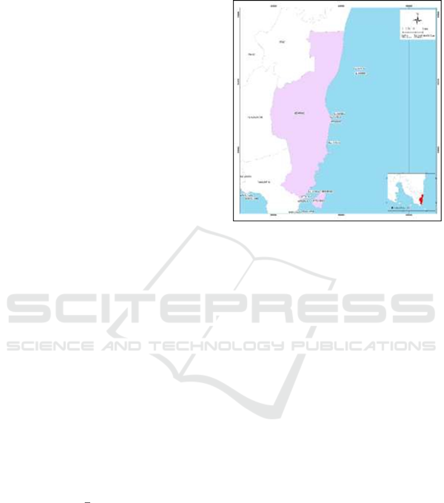
2.1 Area of Study
This research was conducted along the east coast of
South Lampung Regency, Lampung province. Live
observation at the research site is done by going down
the east Coast along + 17 km in 1 (one) sub- district
that is Ketapang which is one of the sub- district close
to the access to the road of Bangun Rejo, shown on
Figure 1.
2.2 Field Surveys
Collection of research data was conducted in May
2019 by walking through the beach using GPS, digital
photos, and video cameras as well as conducting an
interview method directly with the community in the
Figure 1: Area of study.
settlement along the coast. The results of this
observation are also supported with secondary data in
the form of the previous research, namely hydro-
oceanographic data that includes wind data, wave
data, sediment data, bathymetry data as well as
various maps and other data needed as map
topography, administration, land use, population data
and so on that has been obtained from related
agencies.
3 RESULTS
The process of sedimentation and damage to this
coastal structure occurred at the location of Ketapang
Laut village. The location of the sedimentation beach
is one of the locations that belong to the East Coast
region of Lampung province South Lampung and is
located at the location of the coordinates 5
0
44’26.05
"S and 105
0
47 ' 48.21" E shown on Figure 2.
Based on information obtained from the previous
study obtained information from the Pekerjaan
Proyek Pesisir (1998) that the beach is experiencing
sedimentation process and this process tends to be
found many along the east Coast region of Lampung
province. This is because there are many large river
estuary along the coastal areas so that the source of
sediment comes from the mud that is carried away
from the upstream area and precipitates in the estuary.
In addition to the sedimentation problem the field
survey results also showed that the sedimentation
process that occurs constantly causes damage to
Identification of Coastal Problem along the East Coast of Lampung Indonesia
139
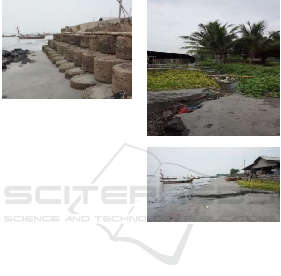
Figure 2: Sedimentation and coastal structure damages.
coastal structure. This type of coastal structure is
revetment. Revetment is a coastal structure that is
built on coastline and is used to protect the coast of
Dai wave attacks and runoff waves (overtopping) to
the ground (Triatmodjo, 2012). Revetment has a
sloped side and can be made from a pile of rocks or
bronzes, making it more flexible and adapts to the
scours at the foot of the building. The revetment that
functioned as a coastal protective structure was
damaged because of the buildup of sediment in the
concrete pile that formed the presence of new land. If
it is reviewed based on the characteristic of the east
coast of Lampung province that has the same
characteristics as the north coast of Java (Sulaiman,
2018) that the coastal area is characterized by the low
slope of the mud and swamp overgrown mangrove
and has a very fine grain size, it is very possible once
the dominant sedimentation process occurs in this
location. The condition of the beach with muddy
characteristics is also very related to the wave energy
is verylow, but the tide is greater. Based on the results
of the research conducted by Tarigan et al. (2020) that
the East Coast of South Lampung has a characteristic
wave height which ranges from 0.36 m-2.57 m. East
coast of South Lampung Regency that has a character
sedimentary mud affects the sediment process that
tends to undergo sedimentation process in the coastal
area (Tarigan et al., 2020).
The process of in the village of Ketapang Laut
South Lampung District, this led to the presence of
land arising causing the increase of river estuary and
the coastline. The ignition of the estuary that occurs
can clog the stream, pollution, the fishing vessel
traffic at low tide and on the other side when the tide
can cause the widespread water over the bank.
People in the village of Ketapang Laut South
Lampung District overcome the blockage of the river
by doing simple dredging such as making a hole that
(a)
(b)
Figure 3: (a) and (b) Sedimentation.
functions to drain the flow of the river to the beach
that shown on Figure 3(a) and Figure 3(b).
Based on the condition of the field obtained
information that if not in the rainy weather conditions,
the river discharge is relatively small so that the
current speed is not able to erosion. The deposition to
a clever consequence of the river estuary completely
covered sedimentary deposits.
This location is very close to the residential area
of residents and also the processing place of salty fish
that have waste, under certain conditions some
residents who live around the area is disturbed by a
puddle that sometimes carries a waste of salty fish
processing that creates unpleasant odor so that the
citizens will be able to join the place in the mouth-
mouth of the river, especially the stream is small.
To solve the problem, it is necessary to do the
treatment to take the entry of sediment to the estuary
of the river. The bank's estuary management strategy
can be determined where the sedimentation of the
ISOCEEN 2019 - The 7th International Seminar on Ocean and Coastal Engineering, Environmental and Natural Disaster Management
140
river mouth is the simplest and least inexpensive
alternative handling (Triatmodjo, 1999). Dredging
can be done at the beginning of the rainy season,
either by mutual assistance by local residents or by
using the help of heavy equipment if possible in the
way of inspection. To get the maximum flow, a large
volume of dredging is required. The difficulty of this
alternative is the re-enlarger groove that is completed
scraped, especially when the wave with greater
energy and also if the interval between the completion
of dredging with the advent of the first flood is still
long enough, so that the groove that has been dredge
will be closed back by deposits. Triatmodjo (1999)
states that when dredging is done by mutual
assistance, the population can choose the thinnest and
most narrow deposits to be scraped on downstream
turns. The purpose is the River estuary remains
turned, so the discharge capacity of the addressing is
reduced.
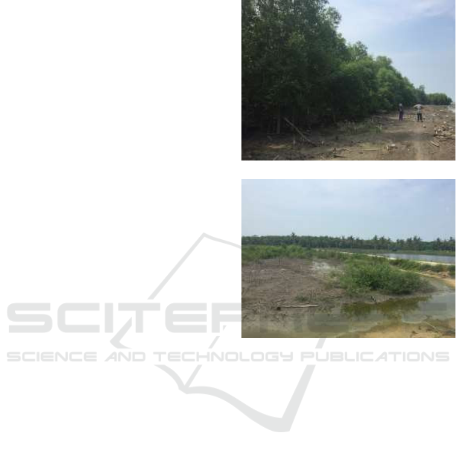
The decrease of mangrove forest land cover that
occurred in the coastal area East coast of South
Lampung district is at the coordinates of 5
0
39 ' 48.76
"S – 105
0
48 ' 41.48" E. Based on the results of field
surveys and interviews with local residents, one of the
causes of damage to the mangrove forest is caused by
the opening of the area to serve shrimp ponds. The
field conditions taken in May 2019 are shown shown
on Figure 4.
Based on the information quoted from previous
research according to resource Atlas of Lampung
coastal area (Wiryawan, 1999) coastal area along the
coast of East Lampung except Way Kambas National
Park occurs the change of land that initially swamp
and mangrove forest into rice farming land and
shrimp pond. The existence of mangrove forest
covering about 81 percent of the beach in Lampung,
can provide many benefits, both physically,
biologically and economically. But excessive
utilization especially on economic utilization can
cause damage to ecosystems. However, if the land
cover area of mangrove forest will be held
continuously, it can cause impact on coastal area and
beach.
Some of the impacts that can occur are coastal
erosion and river borders, sedimentation,
environmental pollution, decline in ecological
function that will affect the economic aspect
especially for fishermen who are in the East Coast
district of South Lampung Regency and will cause sea
water instrusion. Policy recommendation to improve
the mangrove ecosystem and reduce the impact is to
rehabilitate the mangrove ecosystem by actively
involving the community.
(a)
(b)
Figure 4: (a) Mangrove forest area; (b) land conversion.
4 CONCLUSIONS
East Coast of South Lampung regency, Lampung
Province showed that there are coastal damage that
occurred at some point of location and need to get
handling to do ecosistence improvement of coastal
area and integrated beach. The location that is
experiencing the sedimentation process is a location
that affects increasing the economy of the local
population working as fishermen and entrepreneurial
fish processing.
East Coast of South Lampung regency, Lampung
province problem is caused by natural and
anthropogenic factors. Natural factors in the form of
hydro-oceanography can damage ecosystems and
buildings on the coastal borders. Factor
anthropogenic by community activities that do not
comply with local regulations and rules applicable.
Advanced research and studies need to be done to
support the results of the Identification of Coastal
Identification of Coastal Problem along the East Coast of Lampung Indonesia
141

Problem along the East Coast of Lampung Indonesia
by conducting a coastal protection analysis in
accordance with the principles of integrated coastal
management.
ACKNOWLEDGEMENTS
The author thanked the Direktorat Riset dan
Pengabdian Masyarakat, Direktorat Jenderal
Penguatan dan Pengembangan, Kementerian Riset,
Teknologi, dan Pendidikan Tinggi that has given the
research grant of beginner lecturer (PDP) year 2018-
2019 with research contract number is
009/SP2H/LT/DRPM/2018.
REFERENCES
Arief, M., Winarso, G., Prayogo, T., 2011. Kajian
Perubahan Garis Pantai Menggunakan Data Satelit
Landsat di Kabupaten Kendal, Jurnal Penginderaan
Jauh, LAPAN, Volume VIII : 71-80.
Fadilah., Suripin., Dwi P Sasongko., 2013. Identifikasi
Kerusakan Pantai Kabupaten Bengkulu Tengah
Provinsi Bengkulu. Prosiding Seminar Nasional
Pengelolaan Sumberdaya Alam dan Lingkungan.
Hariyoni., Dian S., Suwanto M., 2013. Studi Perencanaan
Bangunan Pengendalian Akresi Dan Abrasi Di Pantai
Tanjungwangi Kabupaten Banyuwangi. Jurnal Teknik
Pengairan, Volume 4, Nomor 1, Mei 2013, hlm 20–29.
Pariwono, J. I., 1999. Kondisi
Oseanografi
Perairan Pesisir
Lampung. Laporan Teknis Penyusunan Atlas
Sumberdaya Wilayah Pesisir Lampung.
Sulaiman, D., 2018. Bangunan Pengendali
Erosi
Pantai
Berlumpur. Penerbit Deepublish. Yogyakarta.
Surat Edaran Menteri Pekerjaan Umum
dan
Perumahan
Rakyat Nomor No. 08/SE/M/2010 tentang
Pemberlakukan Pedoman Penilaian Kerusakan Pantai
Dan Prioritas Penanganannya.
Tarigan, T.A., Nirmawana S., Nanda N., and
Yudha
R.,
2020. Analisis Sedimen dan Pengaruhnya terhadap
Kondisi Garis Pantai di kawasan Pantai Timur
Kabupaten Lampung Selatan. Journal of Science and
Applicative Technology.
Triatmodjo, B., 1999. Teknik Pantai. Penerbit
Beta
Offset,
Yogyakarta
Triatmodjo, B., 2012. Perencanaan
Bangunan
Pantai.
Penerbit Beta Offset, Yogyakarta.
Wiryawan B., B. Marsjen, H. Adi Susanto, A.
K.
Mahi, M
Ahmad, dan H. Poepitasari. 1999.
Atlas Sumberdaya Wilayah Pesisir Lampung. Bandar
Lampung: Pemda Tk I Lampung- CRMP Lampung.
Yin-can YE., 2017. Marine Geo-Hazards in
China
.
Elsevier.
ISOCEEN 2019 - The 7th International Seminar on Ocean and Coastal Engineering, Environmental and Natural Disaster Management
142
