Environmental Conditions in Karimunjawa to Support the
Integrated Multi-Trophic Aquaculture (IMTA) Program
Anita Kusuma Wardhani
1
, Muhammad Zikra
1
, Bambang Semedi
2
and Agung Setyo Mukti
2
1
Department of Ocean Engineering, Institut Teknologi Sepuluh Nopember (ITS), Surabaya, Indonesia
2
Department of Marine Science, Faculty of Fisheries and Marine Science, Brawijaya University, Malang, Indonesia
Keywords: IMTA, Coral Reef, Aquatic Quality, GIS.
Abstract: Karimunjawa National Park is a nature conservation area managed by the zoning system. Of the 9 zones
that have been determined, one of them is the Maritime Cultivation Zone which is intended to support the
interests of aquaculture. Aquaculture based on Integrated Multi-Trophic Aquaculture (IMTA) is a
development system that supports cultivation by integrating a variety of different species. This study aims to
analyze the suitability of Karimunjawa waters based on the measurement of environmental parameters such
as temperature, DO, Ph and current salinity to support IMTA in Karimunjawa waters and observe the coral
reef ecosystem as a supporter of assessing the condition of the aquatic environment. Based on the results of
measurements of environmental parameters, the results obtained are still relatively good quality based on
water quality standards. The average water temperature is 29.7 ° C, dissolved oxygen (DO) is 7 mg / l, pH is
8.1 and salinity is 32.7 ppt.
1 INTRODUCTION
Karimunjawa National Park is designated as a nature
reserve area located in Jepara Regency, Central Java
Province in Decree of the Minister of Forestry and
Plantation No. 78/Kpts-II/1999 dated February 22,
1999, with an area of 111,625 hectares (BTNKJ,
2019). In Law No.5 of 1990 concerning
Conservation of Natural Resources and their
Ecosystems defines national parks as Nature
Conservation Areas that have native ecosystems,
managed with zoning systems that are utilized for
research, science, education, supporting cultivation,
tourism and recreation. Based on Decree of the
Director General of PHKA No. SK 28/IV-
SET/2012 concerning Zoning of Karimunjawa
National Park, currently there are 9 (nine) zones
within the Karimunjawa National Park area. The
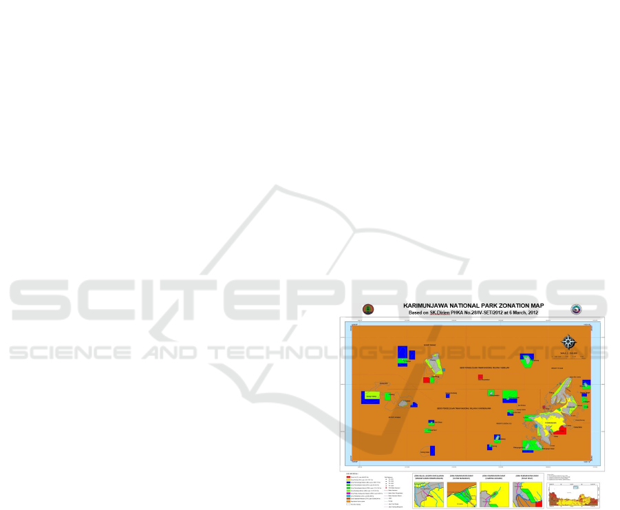
zoning of Karimunjawa National Park is fully
presented in Figure 1. From 9 zones that have been
determined, one of them is the Maritime Cultivation
Zone, which is intended as a supporter of the
interests of aquaculture such as seaweed cultivation,
floating net cages with due regard to conservation
aspects.
Figure 1: Zoning Map of Karimunjawa National Park.
Integrated aquaculture (integrated multi-trophic
aquaculture / IMTA) is an innovation in the
development of an aquaculture system that is
applied to address the issue of the impact of
aquaculture activities on the aquatic environment
including sedimentation and enrichment of aquatic
nutrients (Radiarta et al., 2014; 2015; Alexander et
al., 2016). The IMTA system combines several
different trophic-level species, between species that
are fed (eg fish) and species that absorb inorganic
material (eg seaweed) and species that absorb
76
Wardhani, A., Zikra, M., Semedi, B. and Mukti, A.
Environmental Conditions in Karimunjawa to Support the Integrated Multi-Trophic Aquaculture (IMTA) Program.
DOI: 10.5220/0010056600760082
In Proceedings of the 7th International Seminar on Ocean and Coastal Engineering, Environmental and Natural Disaster Management (ISOCEEN 2019), pages 76-82
ISBN: 978-989-758-516-6
Copyright
c
2021 by SCITEPRESS – Science and Technology Publications, Lda. All rights reserved
organic matter (suspension and deposit feeders
such as shellfish) Troell et al., 2009; Barrington et
al., 2009).
The implementation of the IMTA system not
only produces high economic value biomass
through product diversification but can also reduce
waste entering the waters. In the IMTA system,
waste generated from the main commodities that
enter the waters will be converted and utilized by
species absorbing organic and inorganic materials.
The selection of commodities for the IMTA system
is very flexible, can be adjusted to commodities
that have developed in an area be it fish, seaweed,
or shellfish. The selected commodity is adjusted to
its function in the ecosystem and is a commodity
with high economic value. By choosing the right
cultivation species, this IMTA system will reduce
the organic and inorganic content of nitrogen,
carbon, and phosphate; making this system a
candidate in nutrient trading credits (Chopin et al.,
2010; Yuniarsih et al., 2014).
Analysis of the suitability of the condition of the
waters of Karimunjawa National Park with the
measurement of environmental parameters such as
temperature, salinity, DO, and pH, as well as
observation of marine aquatic ecosystems such as
coral reefs, needs to be done as a first step before the
implementation of aquaculture that supports the
IMTA system. The IMTA system which is considere
to be able to support the conservation aspects is
expected to be able to provide more value to the
environmental sustainability and fishery products
found in the waters of the Karimunjawa National
Park.
2 STUDY AREA
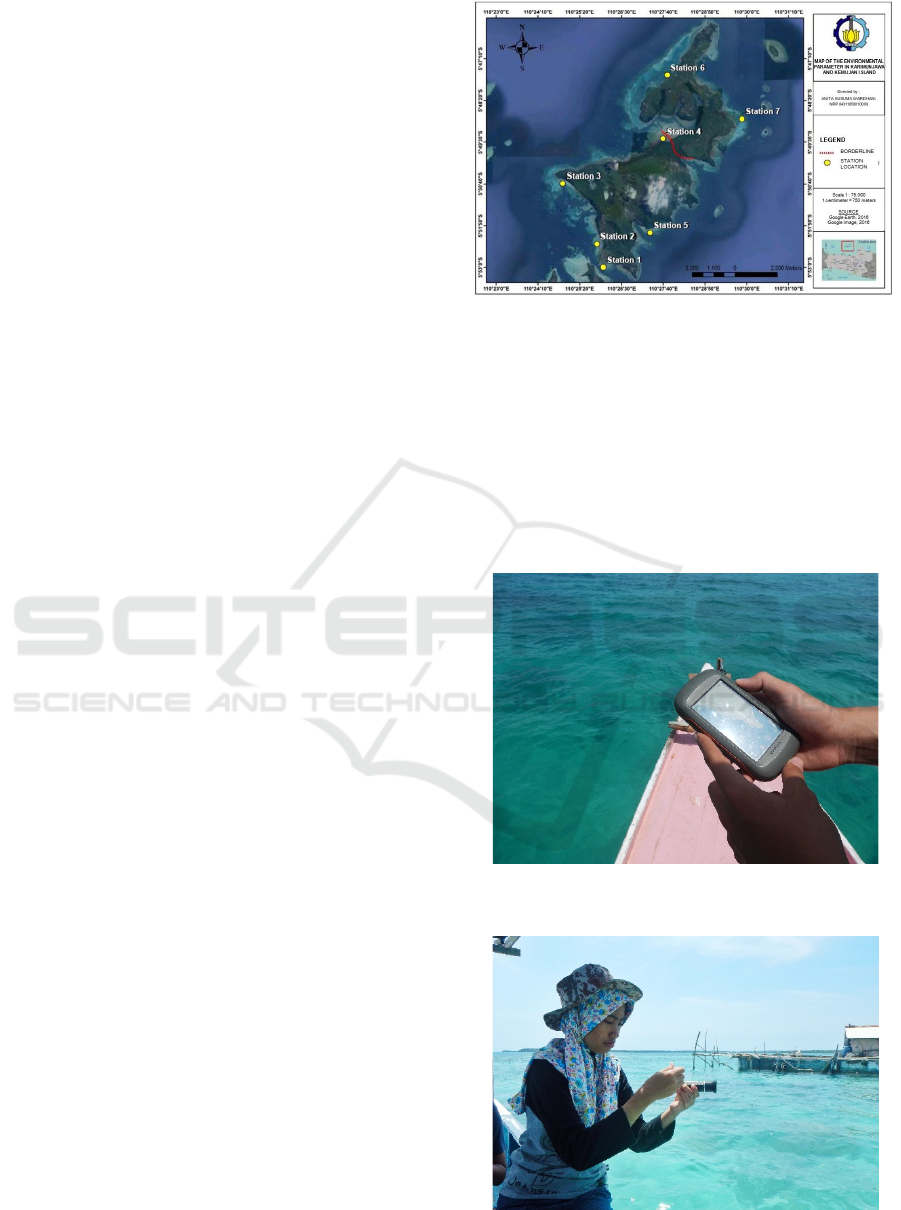
The research location is in the waters of the
Karimunjawa National Park where the focus of the
location is on Karimunjawa Island and Kemujan
Island to take samples of water parameters and
observe the aquatic environment ecosystem.
Sampling is distributed at 7 station points (Figure 2),
including Station 1. Harbour, Station 2. Fishing Port,
Station 3.Ujung Gelam Beach, Station 4.Mangrove
and river mouth, Station 5.Legon Lele/Core Zone,
Station 6.Merican Kemujan Island/Utilization Zone
of Seaweed Cultivation.
Figure 2: Map of Research Location.
3 METODHOLOGY
Parameter measurements are performed at 7 station
points with 3 repetitions at each station point to get
valid results. In this activity, fishing boats are used
to go to 7 predetermined station points with the help
of Global Positioning System (GPS) to obtain
location accuracy (Figure 3).
Figure 3: Global Positioning System (GPS) as a Guide to 7
Station Points.
Figure 4: Water Quality Measurement using
Refractometer for Salinity.
Environmental Conditions in Karimunjawa to Support the Integrated Multi-Trophic Aquaculture (IMTA) Program
77
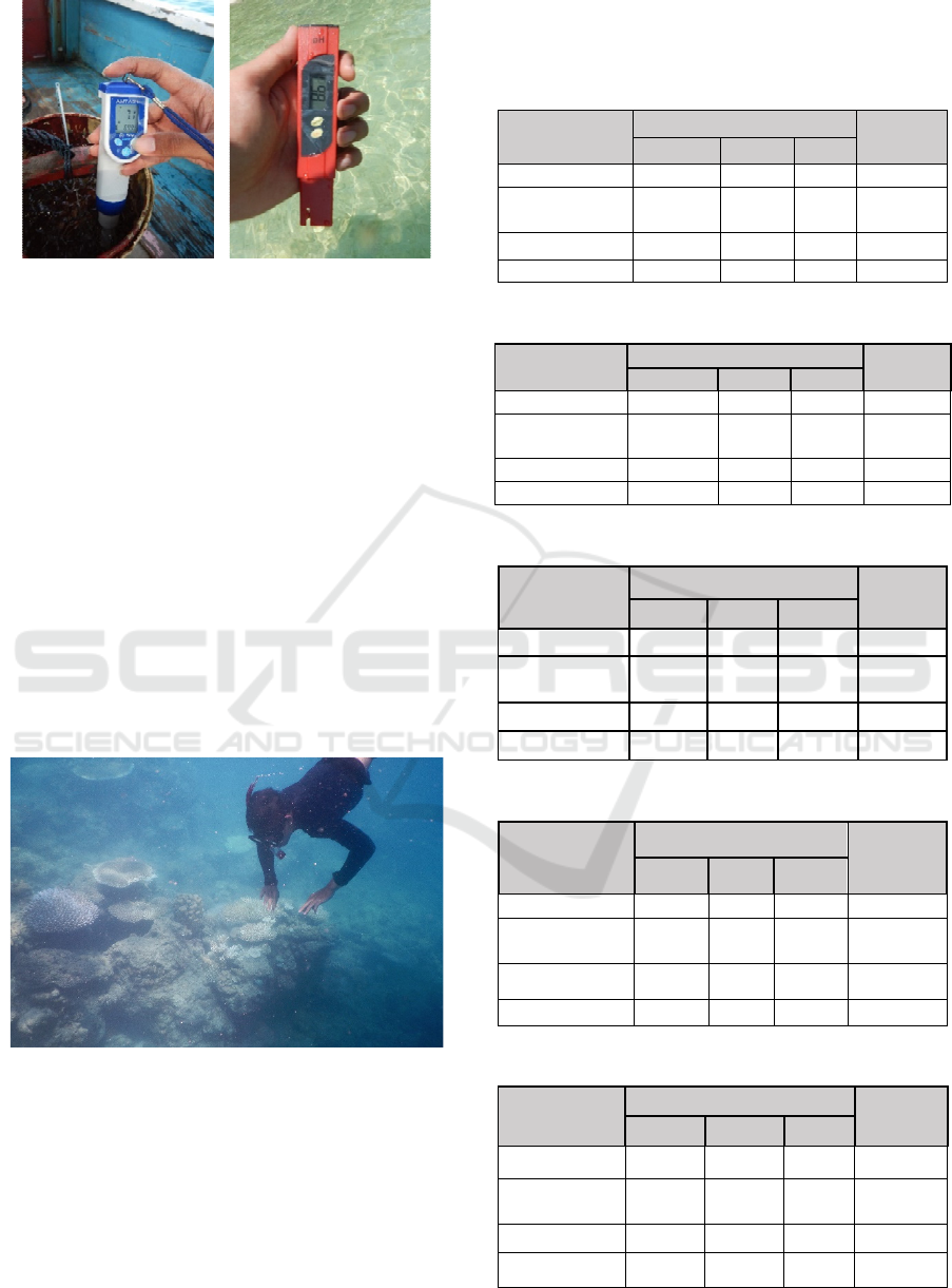
Figure 5: Water Quality Measurement using DO meter and
pH meter.
Temperature measurement using a thermometer,
salinity measurement using a refractometer (Figure
4), dissolved oxygen (DO) measurement using a DO
meter and pH measurement using a pH meter
(Figure 5).
The results of the measurement of environmental
parameters are entered in the Surfer software to be
processed into a map of the distribution of observed
environmental parameters (Figure 7 - Figure 11).
Kriging interpolation is used in data processing
to become a map of the distribution of
environmental parameters.
Observation of the condition of coral reefs is
also done as a consideration to assess quality based
on quality standards. Observations were made using
the GIS method and then carried out during a field
check in the field with snorkelling (Figure 6).
Figure 6: Observation of the Condition of Coral Reefs.
4 RESULT AND DISCUSSION
4.1 Measurement of Water Parameters
Based on 7 predetermined station points, the results
of measurements of water parameters include
temperature, salinity, DO, Ph, and currents in Table
1 to Table 7.
Table 1: Measurement of Water Parameters at Station 1.
Parameter
Repetition
Average
1 2 3
DO
(
m
g
/l
)
6,9 6,7 6,7 6,76
Temperature
(°)
29 29 29 29
pH 8,2 8,2 8,2 8,2
Salinit
y
(pp
t
)
32 32 33 32,2
Table 2: Measurement of Water Parameters at Station 2.
Parameter
Re
p
etition
Average
1 2 3
DO
(
m
g
/l
)
6,4 6,5 6,5 6,46
Temperature
(
°
)
30 30 29 29,6
p
H 8,2 8,2 8,2 8,2
Salinity (ppt) 35 31 31 32,3
Table 3: Measurement of Water Parameters at Station 3.
Parameter
Repetition
Average
1 2 3
DO(mg/l) 7,2 7,3 7,6 7,4
Temperature
(
°
)
29 29 29 29
pH 8,2 8,2 8,2 8,2
Salinity (ppt) 32 33 32 32
Table 4: Measurement of Water Parameters at Station 4.
Parameter
Repetition
Average
1 2 3
DO(mg/l) 6,9 6,7 7,2 6,9
Temperature
(
°
)
30 30 30 30
pH 8,1 8,2 8,1 8,1
Salinity (ppt) 33 33 33 33
Table 5: Measurement of Water Parameters at Station 5.
Parameter
Repetition
Average
1 2 3
DO(mg/l) 7,2 7,2 7,7 7,4
Temperature
(°)
30 30 30 30
pH 8,2 8,2 8,2 8,2
Salinity (ppt) 33 33 33 33
ISOCEEN 2019 - The 7th International Seminar on Ocean and Coastal Engineering, Environmental and Natural Disaster Management
78
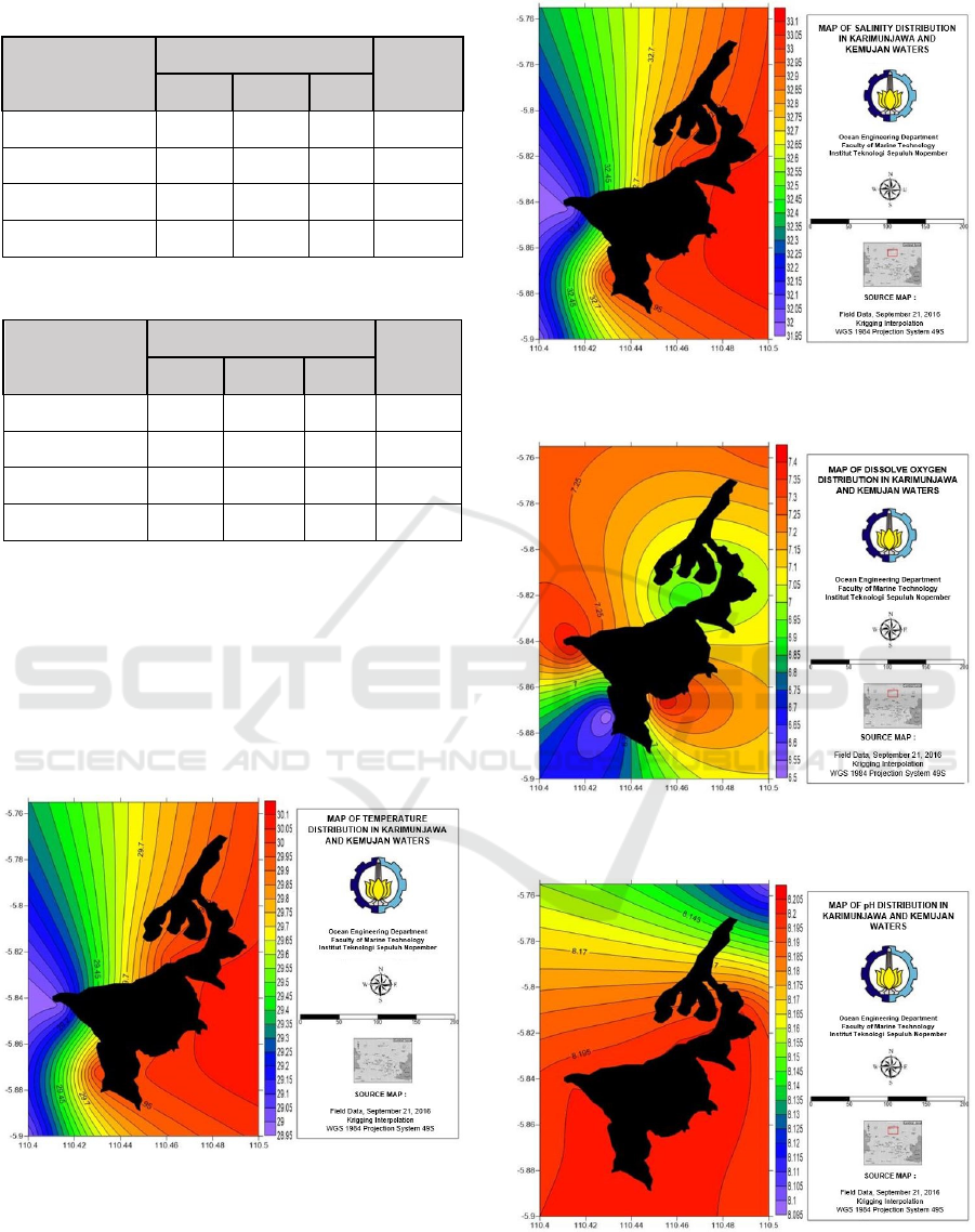
Table 6: Measurement of Water Parameters at Station 6.
Parameter
Repetition
Average
1 2 3
DO(mg/l) 6,9 7,2 7,7 7,3
Temperature (°) 30 30 30 30
pH 8,2 8,2 8,2 8,2
Salinity (ppt) 33 33 33 33
Table 7: Measurement of Water Parameters at Station 7.
Parameter
Repetition
Average
1 2 3
DO(mg/l) 7,0 7,0 7,0 7,0
Temperature (°) 30 30 30 30
pH 8,2 8,2 8,2 8,2
Salinity (ppt) 33 33 33 33
The value of the measurement of the water
parameters is then processed in the Surfer software
to determine the distribution pattern. The results are
shown in Figure 7 through Figure 10.
From the data that has been obtained, it shows
that the results of the measurement of the
environmental parameters of the waters are still
relatively good after compared to the quality
standards (Table 10).
Figure 7: Water Temperatures Distribution on the Island
of Karimunjawa and Kemujan.
Figure 8: Salinity Distribution on the Island of
Karimunjawa and Kemujan.
Figure 9: Dissolve Oxygen Distribution on the Island of
Karimunjawa and Kemujan.
Figure 10: pH Distribution on the Island of Karimunjawa
and Kemujan.
Environmental Conditions in Karimunjawa to Support the Integrated Multi-Trophic Aquaculture (IMTA) Program
79
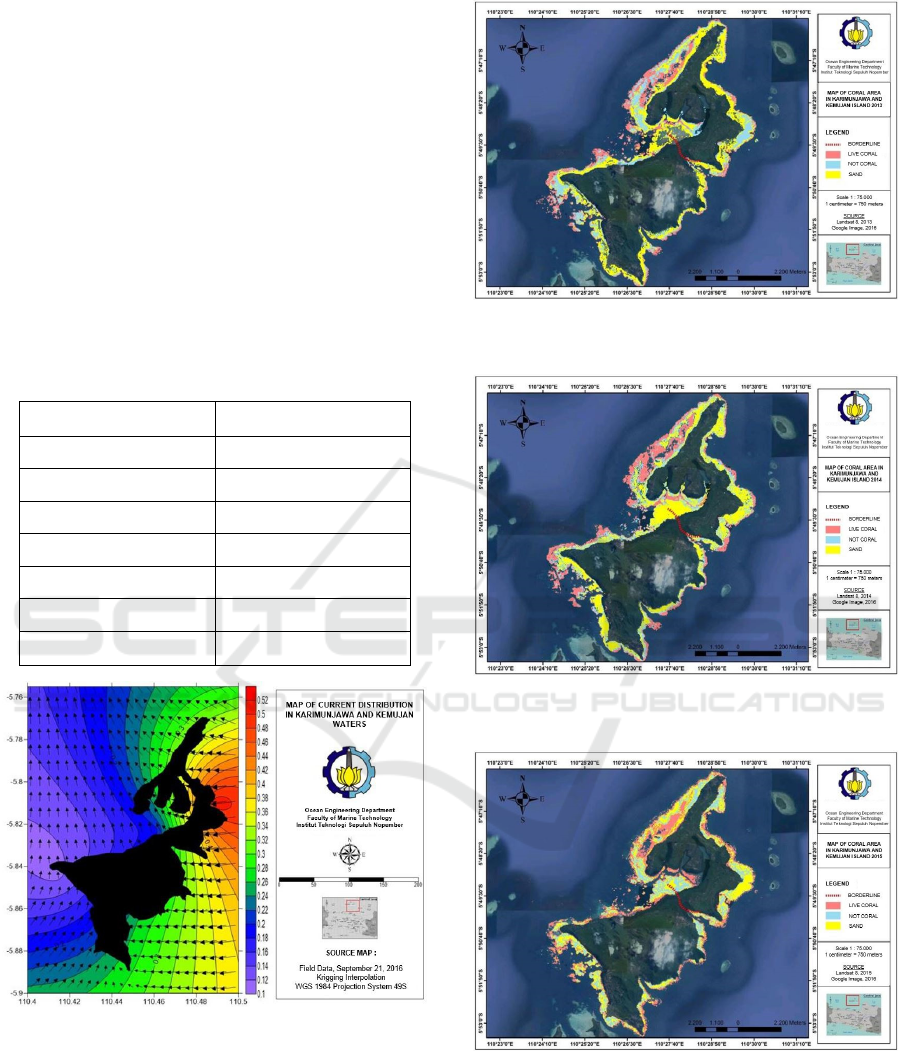
4.2 Sea Current Data Processing
Current data processing in the Surfer software shows
the current velocity in the waters of the islands
Karimunjawa and Kemujan ranging from 0.10 to
0.52 m / s (Table 8). Current data from OSCAR was
taken in September, adjusting for the time when the
ground check is roomy. In September there was the
East to West transition season (September -
November). Current patterns that occur in the waters
around the Karimunjawa Islands are the effects of
changes that are common in Indonesian waters
(Ariyati et al, 2005). The map of the distribution of
current speed can be seen in Figure 7.
Table 8: Current Speed on The Island of Karimunjawa and
Kemujan.
Location Result (m/s)
Station 1 0,248
Station 2 0,205
Station 3 0,113
Station 4 0,193
Station 5 0,268
Station 6 0,280
Station 7 0,514
Figure 11: Current Speed Distribution on the Island of
Karimunjawa and Kemujan.
4.3 Coral Reef Data Processing
As an additional parameter, the condition of the
coral reef ecosystem in the waters of Karimunjawa
Island and Kemujan Island was also observed. Initial
observations were made using the GIS approach
using Landsat 8. Satellite imagery data were taken
Figure 12: Map of Coral Area on the Island of
Karimunjawa and Kemujan in 2013.
Figure 13: Map of Coral Area on the Island of
Karimunjawa and Kemujan in 2014.
Figure 14: Map of Coral Area on the Island of
Karimunjawa and Kemujan in 2015.
within 4 years, namely in 2013, 2014, 2015 and
2016 to see the changes and conditions. In this
study, the 1981 Lyzenga algorithm was used to
classify objects underwater. Detection of objects
below sea level in Landsat data uses blue and red
ISOCEEN 2019 - The 7th International Seminar on Ocean and Coastal Engineering, Environmental and Natural Disaster Management
80
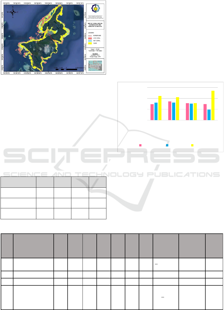
Figure 15: Map of Coral Area on the Island of
Karimunjawa and Kemujan in 2016.
canal data. Kardono (1993) states that the blue and
red canals are the best channels for penetration into
the underwater column because in the blue and red
channels there are wavelengths between 0.5 - 0.6 µm
which are suitable for penetration into the water
column. The following (Figure 12 to Figure 15) is a
map of the extent of coral reefs from 2013 to 2016
on Karimunjawa Island and Kemunjan Island.
Based on the results of the processing of coral
reefs from 2000, 2013, 2014, 2015 and 2016 on
Karimunjawa Island and Kemujan Island can be
seen from Table 9 below:
Table 9: The Extent of Live Coral, Not Coral and Sand.
Class/ Year 2013 2014 2015 2016
Live Coral (Km
2
) 5,864 6,891 6,254 5,914
Not Coral (Km
2
) 6,437 6,456 6,070 3,886
Sand (Km
2
) 8,884 8,430 6,258 10,802
From the above data, the results of the
percentage estimates of the area obtained from the
processing of Landsat satellite image data in 2013,
2014, 2015 and 2016. Classified into 3 classes,
namely live coral, not coral and sand. From 2013 to
2014 the extent of coral reefs increased by 8.7%,
from 5.864 Km2 in 2013 to 6,891Km2 in 2014.
From 2014 to 2015, the area of coral reefs decreased
by 5.1% to 6,254 Km2 in 2015. Then in 2016, there
was also a decrease in the area of coral reefs to
5.9141 Km2 by 2.7%. Following Figure 16 is a
graph of the classification results and the extent of
Landsat satellite imagery data for 2013, 2014, 2015
to 2016.
Figure 16: Results of Classification and Extents from
Processing of Landsat Satellite Imagery.
Based on observations of the parameters of the
quality of waters in Karimunjawa Island at seven
points the location of sampling shows that the
environmental conditions of the waters of
Karimunjawa Island are in "Good" condition for
aquaculture and marine biota, because no sample
parameters were found with values that exceeded the
quality standard as shown in Table 10.
Table 10: Comparison of Measurement Result of Water Parameter with Quality Standards.
Parameter St.1 St.2 St.3 St.4 St.5 St.6 St.7
Marine
Biota
Quality
Standards
Coral Reef
Quality
Standards
Status
1 Temperature (
o
C) 29 30 29 30 30 30 30
+2 natural
variation
28-30 Good
2 DO (mg/l) 6,7 6,46 7,4 6,9 7,4 7,3 7,0 >5 Good
3 PH 8,2 8,2 8,2 8,1 8,2 8,2 8,2 6,5 - 8,5 7-8,5 Good
4 Salinity (%
0
) 32 33 32 33 33 33 33
18 -
32/+10
natural
variation
33-34 Good
0
4 000
8 000
12 000
2013 2014 2015 2016
Area (Km²)
Year
Live Coral Not Coral Sand
Environmental Conditions in Karimunjawa to Support the Integrated Multi-Trophic Aquaculture (IMTA) Program
81

5 CONCLUSIONS
Based on observations of the quality parameters of
the waters of Karimunjawa Island at 7 points of the
sampling station, it shows that the environmental
conditions of the waters of Karimunjawa Island are
in "Good" condition for the cultivation and
ecosystem of coral reefs. Climate change and human
activities are also thought to affect environmental
conditions and changes in the size of coral reefs.
ACKNOWLEDGEMENTS
We are grateful for the close collaboration between
Institut Teknologi Sepuluh Nopember and Brawijaya
University in completing this study. Special thanks
to Karimunjawa National Park Agency for providing
facilities and supports.
REFERENCES
Alexander, K.A., Angel, D., Freeman, S., Israel, D.,
Johansen, J., Kletou, D., Meland, M., Pecorino, D.,
Rebours, C., Rousou, M., Shorten, M., & Potts, T.
(2016). Improving sustainability of aquaculture in
Europe: Stakeholder dialogues on integrated multi-
trophic aquaculture (IMTA). Environmental Science
& Policy, 55, 96-106.
Ariyati, R.W., Syu’runi L., Arini. E. 2005 Analisis
Kesesuaian Perairan Pulau Karimunjawa dan Pulau
Kemujan Sebagai Lahan Budidaya Rumput Laut
Menggunakan Sistem Informasi Geografis.Jurnal Pasir
Laut Vol.5 Juli 2007:/25-40
Barrington, K., Chopin, T., & Robinson, S. (2009).
Integrated multi-trophic aquaculture (IMTA) in
marine temperate waters. In Soto, D. (Ed.). Integrated
mariculture: a global review. FAO Fisheries and
Aquaculture Technical Paper No. 529. FAO. Rome, p.
7-46.
Balai Taman Nasional Karimunjawa (BTNKJ). 2019.
Statistik Balai Taman Nasional Karimunjawa.
Kementerian Lingkungan Hidup dan Kehutanan
Direktorat Jenderal Konservasi Sumber Daya Alam
dan Ekosistem Balai Taman Nasional Karimun Jawa.
Semarang.
Kardono, P. Suprajaka. 1993. Teknologi Inderaja untuk
Kelautan dalam GEOMATIKA. BAKOSURTANAL.
Jakarta.
Radiarta, I N., Erlania, & Sugama, K. (2014). Budidaya
rumput laut, Kappaphycus alvarezii secara
terintegrasi dengan ikan kerapu di Teluk Gerupuk
Kabupaten Lombok Tengah, Nusa Tenggara Barat. J.
Ris. Akuakultur, 9(1), 125-134.
Radiarta, I N., & Erlania. (2015). Indeks kualitas air dan
sebaran nutrien sekitar budidaya laut terintegrasi di
perairan Teluk Ekas, Nusa Tenggara Barat: aspek
penting budidaya laut. J. Ris. Akuakultur, 10(1), 141-
152.
Surat Keputusan Kementrian Kehutanan Direktorat
Jenderal Perlindungan Hutan dan Konservasi Alam.
2012. Zonasi Taman Nasional Karimunjawa.
Troell, M. (2009). Integrated marine and brackishwater
aquaculture in tropical regions: research,
implementation and prospects. In Soto, D. (Ed.).
Integrated mariculture: a global review. FAO
Fisheries and Aquaculture Technical Paper No. 529.
FAO. Rome, p. 47–131.
Yuniarsih, E., Nirmala, K., & Radiarta, I N. (2014).
Tingkat penyerapan nitrogen dan fosfor pada
budidaya rumput laut berbasis IMTA (integrated
multi-trophic aquaculture) di Teluk Gerupuk, Lombok
Tengah, Nusa Tenggara Barat. J. Ris. Akuakultur,
9(3), 487-501.
ISOCEEN 2019 - The 7th International Seminar on Ocean and Coastal Engineering, Environmental and Natural Disaster Management
82
