
Analysis of the Implementation of the Lamong Bay Reclamation
based on the Implementation of UU No. 27 of 2007
Widi Agoes Pratikto, Suntoyo, Dirta Marina Chamelia, Kriyo Sambodho, Raditya Danu Riyanto,
Silvianita, Sholihin, Muhammad Ilham Maulana, Rendatiyarso Laksono and Wetta Inggrid Sari
Ocean Engineering Departement, Faculty of Marine Technology, Institut Teknologi Sepuluh Nopember,
Surabaya 60111, Indonesia
Keywords: Reclamation, Lamong Bay, UU No. 27 of 2007.
Abstract: Lamong Bay coast is a rich coastal area, this is because there are many fish habitats, marine biota habitats,
mangroves, and other fisheries activities. But in 2010 there were reclamation activities by PT. Pelindo III
which aims to increase the loading and unloading capacity of container terminals, waterfront city
development, and multi-purpose terminals. By implementing UU No. 27 of 2007, the community service
paper based on this research will explain the results of the study and evaluation in the implementation of the
reclamation in Lamong Bay which will then be socialized to the community so that harmony is created
between business permit holders and coastal communities of Lamong Bay.
1 INTRODUCTION
Lamong Bay is one of the strategic areas in Surabaya,
East Java. In Lamong Bay, this also includes the
Coastal area which has many fish habitats and marine
biota. Around this area there are also many
mangroves and fishermen. Through the Minister of
Transportation's decision No. 4 of 1997 the Central
Government issued a policy of granting permits to
PT. Pelindo III to carry out beach reclamation or
reclamation in the Tanjung Perak Port and Gresik
Port working areas in the Lamong Bay area.
In Law No. 27 of 2007 Republic of Indonesia how
to regulate activities carried out by people in order to
increase the benefits of land resources in terms of
environmental and socio-economic point of view by
means of drainage, land drainage or drainage.
Through PT. Pelindo III activities in the reclamation
or reclamation of Teluk Lamong are carried out to
increase the loading and unloading capacity and
container terminals, waterfront city development, and
building multi-purpose terminals. Of course,
reclamation activities can be done easily. All aspects
must meet the criteria established by the applicable
laws and regulations. All types of risks and challenges
must have been issued, both those that have been
resolved technically and socially by the community.
*
Author
Thus beyond the risks and challenges arising from
the reclamation activities, it is necessary to conduct a
study and evaluation in the implementation of the
reclamation in the Lamong Bay area. Whether in the
implementation of this reclamation activity is in line
with the implementation of Law No. 27 of 2007. With
the suitability of the procedures carried out starting
from the planning process to completion, it is
expected to be minimized as early as possible
The activivity of reclamation relates to the
provincial Perda on Zonation based upon Act
(UU) 26 Tahun 2007 and 27 Tahun 2007
junction UU 1 Tahun 2014
Were there any Challenges and Obstacles in the
Implementation toward Communities in the said
areas.
2 THEORETICAL BASIC
2.1 Reclamation
Reclamation is an activity carried out by humans in
the context of increasing the benefits of land
resources in terms of environmental and socio-
economic point of view by means of drainage,
drainage or drainage. The reclamation limits set forth
54
Pratikto, W., Suntoyo, ., Chamelia, D., Sambodho, K., Riyanto, R., Silvianita, ., Sholihin, ., Maulana, M., Laksono, R. and Sari, W.
Analysis of the Implementation of the Lamong Bay Reclamation based on the Implementation of UU No. 27 of 2007.
DOI: 10.5220/0010048900540059
In Proceedings of the 7th International Seminar on Ocean and Coastal Engineering, Environmental and Natural Disaster Management (ISOCEEN 2019), pages 54-59
ISBN: 978-989-758-516-6
Copyright
c
2021 by SCITEPRESS – Science and Technology Publications, Lda. All rights reserved
in this report are reclamations carried out in coastal
areas. The coastal area in question encompasses areas
where ashore is still affected by marine processes and
towards the sea as far as 12 miles. Activities that can
be categorized as reclamation include all activities of
adding dry land in coastal areas that result in changes
in the shape of the morphology and coastal land use.
The reclamation system can be divided into four,
namely the pile system, polder system, the combined
system of pile and polder and drainage system. The
explanation of each system is as follows:
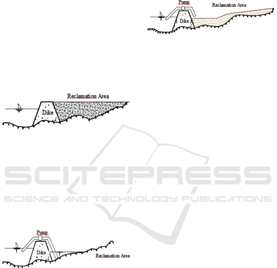
1. Dumping System
Reclamation is done by hoarding coastal waters
until the land surface is above the high sea level (high
water level).
Figure 1: Reclamation of Dumping System.
The advantage of the embankment method is that
the reclaimed land is always above sea level so that
the facilities to be built on this land are relatively safe
from excessive waves or standing water. While the
weakness or disadvantage is the relatively large
volume of landfill for land development.
2. Polder System
Reclamation is done by draining the waters to be
reclaimed by pumping water that is in a watertight
embankment to be discharged out of the reclaimed
land area.
Figure 2: Reclamation of Polder System.
The advantage of reclamation with this system is
the relatively small pile material requirements, but the
loss is always threatened by standing water either
from seawater or from rainwater. Thus the
operational and maintenance costs for the drainage
system require substantial funds.
3. Combination System between Polders and Piles
Reclamation of this system is a combination of the
Polder System and the Dump System, that is after the
land is obtained by the pumping method, then the land
is buried to a certain height so that the difference in
elevation between the reclamation land and sea level
is not large.
Figure 3: Reclamation of Combination System Polders and
Piles.
4. Drainage System
Reclamation of this system is used for coastal
areas that are flat and relatively low from the
surrounding area but the land surface elevation is still
higher than sea level elevation. This area can be a
tidal swamp area or swamp area that is not affected
by tides.
5. Aspects to be considered in reclamation
Reclamation, pre-reclamation, reclamation and
post-reclamation activities must pay attention to
several aspects, including physical aspects,
ecological aspects, legal aspects, socio-economic
aspects, and other supporting aspects.
2.2 UU Number 27 th 2007 concerning
Management of Coastal Areas
Following the nature of the Unitary State of the
Republic of Indonesia as a state of law, the
development of a Management System for Coastal
Areas and Small Islands as part of sustainable
development with an environmental perspective must
be given a clear, firm and comprehensive legal basis
to ensure legal certainty. The legal basis was based on
Pancasila and the 1945 Constitution of the Republic
of Indonesia.
One example of exploitation that can have an
impact on society is reclamation activities. In UU No.
27 of 2007, Reclamation of Coastal Areas and Small
Islands is carried out to increase the benefits and/or
value-added of Coastal Areas and Small Islands in
terms of technical, environmental and socio-
economic aspects. The implementation of the
reclamation as intended is obliged to maintain and
pay attention to:
Sustainability of community life and
livelihood.
The balance between the interests of
utilization and the importance of preserving
the environmental functions of the Coast and
Small Islands.
Technical requirements for the collection,
dredging and stockpiling of materials.
Analysis of the Implementation of the Lamong Bay Reclamation based on the Implementation of UU No. 27 of 2007
55

In the implementation and construction of a
reclamation project, the scope of the Act consists
mainly of five parts, namely planning, licensing,
implementation, monitoring and evaluation, and
transitional provisions.
2.2 Zoning Regulation
The zoning regulation is a tool for control that
regulates the requirements for spatial use and the
provisions for its control which are compiled for each
block/designation zone (UU No. 26 of 2007 on
Spatial Planning), where the block/zone designation
as a reference is determined through a detailed plan
spatial. This zoning regulation is better known as the
popular zoning regulation, where the word zoning
refers to the division of the city environment into
zones of spatial use wherein each of these zones the
control of spatial use is determined or different legal
provisions apply (Barnet, 1982 ).
In the implementation of an area, development is
often not in line with the spatial plan that has been
prepared and makes both of them a conflicting
product. The spatial plan that has been compiled will
remain a document while the implementation of
development continues to run based on market
demand. control system is very necessary and must be
prepared carefully in development planning. UU No.
26 of 2007 concerning Spatial Planning explained
that the control is part of the spatial planning process
that seeks to realize the spatial order. This activity is
carried out to ensure that the process of spatial use is
following the applicable spatial plan. The
Reclamation implementation also should compliance
to UU No 27 of 2007 juncto UU No 1 of 2014 in
regards environmental and communities who live in
the area.
In implementing the laws and regulations, the
areas that are supposed to be used as development
areas are misused by the community or local
institutions. Therefore the zoning of the area that had
been determined by the Government was reduced and
finally, the addition of the Zoning Development Zone
was determined.
Function and purpose of zoning control:
Function to improve an activity that has lasted
a long time but its existence is not following the
existing spatial plan.
Function to prevent development that is not
following the references that have been
prepared.
The two control functions are directed for two
purposes, namely to direct and encourage
development under existing legislation and vision and
mission rather than development itself. in connection
with the implementation of spatial planning,
functions and objectives of this control are carried out
based on the spatial plan that has been prepared,
where the spatial plan reflects the vision and mission
of development to be achieved.
3 RESEARCH METHODOLOGY
Site visit to conduct interviews with the
community to find out whether there are
environmental or social changes that occurred
after the development of the Lamong Bay
reclamation.
Observation was carried out by visiting the
Coastal Around Lamong Bay to collect data by
giving interviews as well as questionnaires to
the surrounding community as well as
observing environmental conditions in the
reclamation area.
Observation data that have been obtained will
be analyzed how reclamation involvement is
carried out in the Lamong Bay area with the
implementation of Law No. 27 of 2007.
Presentation of the results of the analysis will
be submitted to the surrounding community.
This activity is carried out in the Village Hall
or Pendopo District by providing information
on the proper and correct reclamation
procedures.
4 RESULTS OF COMMUNITY
SERVICE
In 2010, Pelindo III built this terminal to improve port
competitiveness. The construction of this project is
one of the infrastructure developments included in the
Master Plan for the Acceleration and Expansion of
Indonesian Economic Development or commonly
abbreviated as MP3EI because Tanjung Perak Harbor
is currently overcapacity. So it takes another place as
an new areas to solution. Furthermore, the Teluk
Lamong Terminal is expected to be the gateway to the
economy of the eastern Indonesia region and to
become an alternative anchorage for logistic service
users and businesses.
The construction of this terminal is planned with
sufficient depth so that large ships can come to carry
out loading and unloading activities. This terminal is
specifically for dry bulk and container loads. But in
practice, the operation of this terminal is also
ISOCEEN 2019 - The 7th International Seminar on Ocean and Coastal Engineering, Environmental and Natural Disaster Management
56
earmarked by liquid bulk loads due to the lack of
accommodation received.
The Teluk Lamong Terminal will go through
several phases of development:
a. Phase I
It took place between 2010 - 2014. During this phase,
the placement and construction of major
infrastructure were carried out such as the jetty
(domestic/international), stacking fields, and
interchange land. Besides, procurement of loading
and unloading equipment such as ship to shore (STS),
ship unloader and automated stacking crane (ASC) is
also carried out.
b. Phase II
This phase took place in 2014-2016. The
development entered the process of increasing the
number of loading and unloading equipment,
expansion of the stockpile area, construction of a dry
bulk dock area along with with a stacking field and
the construction of a power plant area.
c. Phase III
Phase III will be carried out in 2016 – 2023. In this
phase, additional distribution area construction and
consolidation of container depots will be made using
monorails. Besides, there are additional port facilities
such as Container Crane, Ship Unloader, Automated
Stacking Crane, etc.
d. Phase IV
Phase IV is planned to be carried out in 2023 – 2030.
At this stage it is planned to expand the location of
the pier and the stacking field and increase the port
equipment facilities.
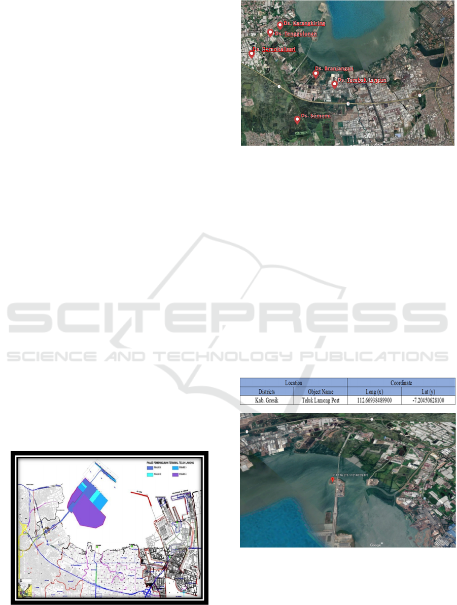
The following is the reclamation of the Lamong Bay
reclamation layout (layout details are attached) and
the condition of the Lamong Bay real estate when
viewed from Google Earth.
Figure 4: Stage Design Layout at Lamong Bay Terminal.
Figure 5: Real Condition at Lamong Bay Terminal.
The implementation of the Lamong Bay
reclamation has been running for 9 years starting
from 2010 which consists of several phases that have
been described previously. At present the
implementation of development has reached the 3rd
stage and is planned to be finished until 2023. If it is
seen from the use of the coastal area it seems that the
reclamation phase that has been carried out from the
first stage does not cause significant problems. The
same thing applies in the second stage. This Han is
the basis of that in Perda No. 1 Year 2018 Teluk
Lamong Port is the Area of Utilization of Umun
namely the Port. The following is the attachment to
Perda No. 1 of 2018 which confirmed that the
Lamong Bay was allowed as a port facility.
Table 1: Location of Lamong Bay Zoning Coordinates.
Figure 6: Port Coordinates According to Perda Zoning No.
1 of 2018.
Analysis of the Implementation of the Lamong Bay Reclamation based on the Implementation of UU No. 27 of 2007
57
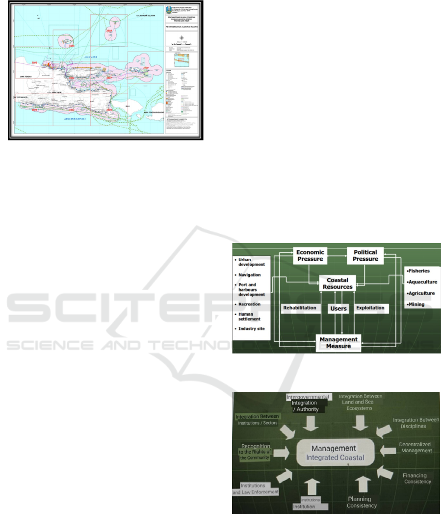
Figure 7: Zoning Plan for Coastal Areas and Small Islands
RZWP-3K East Java Province 2018-2038.
Now, It can be understood that the
implementation of the Lamong Bay reclamation in
phase 1 (2010-2014) and phase 2 (2014-2016) has
been completed, and phase 3 (2016-2023) which is
still running until now can be categorized according
to the zonation stipulated, namely Zone of Public Use
Port Area. However, socialization in its
implementation needs to be communicated to
districts, sub-districts, and even the general public so
that the meeting point and integration between
agencies can be achieved
In carrying out the construction of Among Bay
reclamation must be escorted both by the government
or community intense. In this case, the party that has
the authority in the implementation of the Lamong
Bay Reclamation is the Provincial Government. The
authority of the Lamong Bay reclamation
development is not the property of the Government of
the city of Surabaya or the Government of the city of
Gresik as a city directly affected by the reclamation
activity. But in Pergub No. 1 of 2018 regulates that
coastal areas are assets of the province. (Note: UU
No. 23 of 2014 concerning Regional Government).
So that licensing to revocation of licenses is also the
authority of the provincial government with various
considerations from relevant agencies, namely:
Provincial Government
City / Regency Government
BAPPEDA
Transportation Agency
Maritime and Fisheries Service
Environmental Agency, etc.
The thing to know is that there are people who feel
less fortunate in the implementation of the Lamong
Bay Reclamation. Indeed reclamation can
momentarily have an impact on the livelihoods of
surrounding communities but that does not mean
eliminating their livelihoods.
The main purpose of this project development is
that in the future it will greatly affect the community,
especially the nation’s next generation. This
development can help accommodation and
distribution of goods to facilitate economic flows that
occur. But what needs to be underlined is that the
management of this activity must be right on target so
that the main targets and objectives can be achieved
as well as communication between related agencies.
In practice, the application of UU No. 27 of 2007
in conjunction with UU No. 1 of 2014 is the
implementation of the integrated coastal area
management concept. ICZM (Integrated Coastal
Zone Management), which provides
formulations/suggestions in management procedures
that contain integration between the center and the
regions, between provinces and districts and then
between agencies. By prioritizing sitting together and
maintaining communication between related
agencies, it is hoped that harmony between agencies
is maintained.
Figure 8: Integration and Integrated Management of
Coastal and Marine Region.
Figure 9: Cohesiveness of ICZM (Integrated Coastal Zone
Management).
For fishermen both fish and salt, the municipal
government and Maritime and Fisheries Service, also
continue to try to become facilitators in the
sustainability of the communities in the coastal areas.
Workable solutions include:
ISOCEEN 2019 - The 7th International Seminar on Ocean and Coastal Engineering, Environmental and Natural Disaster Management
58

Transfer of the concept of community
livelihood in some areas towards coastal
ecotourism.
Transfer of fisheries and fishponds that have
been displaced by reclamation activities.
Absorption of community labor directly
affected by the reclamation of Lamong Bay.
5 CONCLUSIONS
The conclusion of this community service are:
Teluk Lamong has been carried out in 4 phases
starting from 2010 and planned to be completed
until 2030 under PELINDO III's needs as a
means of distribution of containers and dry
bulk loads. Implementation of UU No. 27 of
2007 is to issue zoning plans for coastal areas
and small islands as outlined in UU No. 26 of
2007 through the PERDA of East Java
Province No. 1 of 2018. the implementation of
lamong bay reclamation is following the
specified zoning, namely the Port General Use
Area. However, socialization in the application
needs to be communicated.
In practice, the application of UU No. 27 of
2007 in conjunction with UU No. 1 of 2014 is
the implementation of the integrated coastal
area management concept. ICZM (Integrated
Coastal Zone Management) provides
formulations/suggestions in management
procedures that contain integration between the
center and the regions, between provinces and
districts and then between agencies. by
prioritizing sitting together and maintaining
communication between relevant agencies.
thus, harmony between agencies is expected to
be maintained.
It is hoped that communication between
relevant stakeholders can make development
sustainable. The main objective of the
development of this project is that in the future
it will have a big impact on the community,
especially the nation's next generation. This
project can help the accommodation and
distribution of goods to facilitate economic
flows that occur. But what needs to be
underlined is that the management of these
activities must be right on target so that the
main targets and objectives can be achieved.
The local government and related agencies will
also continue to develop the potential that
exists in the area around the Lamong Bay
reclamation.
6 SUGGESTIONS
In the reclamation procedure which began in 2010
and the plan until 2030, it turns out that there are some
residents who need assistance, one of which is the
placement of workers, this can be overcome through
increased communication between agencies so that it
can provide positive results. Further studies are
expected to be able to determine the potential of
coastal areas in the reclamation area so as to
overcome these problems.
REFERENCES
Clark,J.R., 1996. Coastal Zone Management Hand Book.
Lewis Publishers
Dahuri, R., Rais J., Ginting S.P., Sitepu. M.J., 1996.
Pengelolaan Sumber Daya Wilayah Pesisir dan Lautan
Secara Terpadu, PT. Pradnya Paramita, Jakarta.
Gulö, W., (2002), Metodologi Penelitian, PT. Gramedia
Widiasarana Indonesia, Jakarta.
Pemerintah Indonesia. 2007. Undang-Undang No. 27
Tahun 2007 Yang Mengatur Tentang Pengelolahan
Wilayah Pesisir Dan Pulau-Pulau Kecil. Lembaran
Negara RI Tahun 2007, No. 27. Sekretariat Negara.
Jakarta.
Pemerintah Indonesia. 2007. Undang-Undang No. 26
Tahun 2007 Yang Mengatur Tentang Tata Ruang.
Lembaran Negara RI Tahun 2007, No. 26. Sekretariat
Negara. Jakarta.
Pemerintah Indonesia. 2012. Peraturan Presiden No. 122
Tahun 2012 Yang Mengatur Tentang Reklamasi Di
Wilayah Pesisir dan Pulau-Pulau Kecil. Lembaran
Negara RI Tahun 2012, No. 122. Sekretariat Negara.
Jakarta.
Pemerintah Indonesia. 2014. Undang-Undang No. 1 Tahun
2014 Yang Mengatur Tentang Pengelolahan Wilayah
Pesisir Dan Pulau-Pulau Kecil. Lembaran Negara RI
Tahun 2014, No. 1. Sekretariat Negara. Jakarta.
Pemerintah Indonesia. 2018. Peraturan Daerah No. 1 Tahun
2012 Rencana Zonasi Wilayah Pesisir dan Pulau-pulau
Kecil Provinsi Jawa Timur 2018-2038. Lembaran
Daerah Provinsi Jawa Timur Tahun 2018, No. 1 Seri D.
Sekretaris Daerah. Jawa Timur.
Pratikto, A. Widi (2004), Pedoman Reklamasi Di Wilayah
Pesisir. Direktorat Bina Pesisir. Jakarta
Analysis of the Implementation of the Lamong Bay Reclamation based on the Implementation of UU No. 27 of 2007
59
