
Study on Implementation of Green City Concept
in the Suburbs of Semarang City based on Landuse
Teguh Prihanto
1
, Saratri Wilonoyudho
1
and Wahid Akhsin Budi Nur Sidiq
2
1
Study Program of Architecture, Faculty of Engineering, Universitas Negeri Semarang (UNNES)
2
Study Program of Regional Survey and Mapping, Faculty of Social Science, Universitas Negeri Semarang (UNNES)
Keywords: Green city, Semarang, Suburbs.
Abstract: Semarang city is in the highest position in the regional sphere of Central Java which still grows in the socio-
economic sector of settlements which tends to push the function of the city towards the suburbs. The suburbs
which have mountainous topography conditions in Higher Areas of Semarang City have strategic value. With
this condition, Semarang City is vulnerable to the impacts of climate change. One effort to anticipate climate
change is to implement the development of a green city concept based on a balance between urban
development and environmental sustainability. The specific purpose of the study is to examine the
implementation of the green city concept towards the development based on landuse in Higher Areas of
Semarang City. Research locations are in Banyumanik and Gunungpati Sub-districts. By using exploratory
research methods in collecting and analyzing data, Banyumanik has 49% building area and 51% open space
area. In other hand, Gunungpati has 22.1% building area and 77.9% open space area. The results of the
research show that Banyumanik has Banyumanik has a higher agglomeration rate of Semarang City compared
to Gunungpati, and has a risk of environmental vulnerability.
1 INTRODUCTION
Generally, the development of landuse in of
Semarang City which tends to be uncontrolled has a
lot of negative effects on the environment. More
broadly add to the impact of global climate change.
The results of a vulnerability study show that the
phenomenon of climate change has occurred.
Temperature increases are expected to occur so as to
increase rainfall especially during the rainy season.
On the other hand, rising temperatures also induce an
increase in sea level. These two impacts increase the
incidence of flooding and inundation in coastal areas,
and also the degradation of land carrying capacity
resulting in landslides in mountainous areas (Higher
area of Semarang City). As a center of economic and
population concentration, the Semarang City is
vulnerable to the impacts of climate change. Green
open spaces, water sources, and catchment areas are
very limited so that if there is a change in rainfall, the
risk becomes greater.
One effort to anticipate climate change is to
implement the development of the concept of a green
city, which is known as an ecological city or a healthy
city. It has an understanding of the balance between
the development of the city and environmental
sustainability. A healthy city also means a safe,
comfortable, clean and healthy city condition to
inhabit its population by optimizing the potential
through empowering community forums, facilitated
by related sectors and in sync with city planning. To
be able to make it happen, it takes effort from each
individual member of the community and all
stakeholders. With the application of the concept of a
green city, urban environmental crises can be
avoided, as is the case in large cities and metropolitan
areas that have experienced urban obesity. Urban
development with this environmentally friendly
concept, generally contributes greatly to the reduction
of the impacts of global climate change and
specifically provides the carrying capacity of the
suburbs of Semarang City over those that have a
conservation function.
1.1 Structure and Development of City
The elements that influence the development of
the city are the geographical condition, site, city
function, city history and culture and the stages of
urban development (Branch, 1985). Geographical
184
Prihanto, T., Wilonoyudho, S. and Akhsin Budi Nur Sidiq, W.
Study on Implementation of Green City Concept in the Suburbs of Semarang City based on Landuse.
DOI: 10.5220/0009008201840189
In Proceedings of the 7th Engineering International Conference on Education, Concept and Application on Green Technology (EIC 2018), pages 184-189
ISBN: 978-989-758-411-4
Copyright
c
2020 by SCITEPRESS – Science and Technology Publications, Lda. All rights reserved

conditions and sites affect the function and physical
form of the city. The function carried out by the city
will show its existence, while the history and culture
of the city will influence the character and nature of
the city.
Kevin Lynch (1971) suggests that now is a period
of rapid growth and various institutions, including
university campuses, hospitals, government units and
cultural centers
1.2 Landuse Policy of Semarang City
Based on the Regional Spatial Plan of Semarang City
(Rencana Tata Ruang Wilayah / RTRW 2011 - 2031,
the main function of the location of the sub-district
area which is the scope of the research are:
Banyumanik Sub-district (± 2,509 ha) is
included in BWK VII (the boundary of city
area / Batas Wilayah Kota), the main function
is: military special area
Gunungpati Sub-district (± 5,399 ha) is
included in BWK VIII, the main function is:
higher education area.
Both regions in the plan of the spatial pattern have
a function as a protected area, which provides
protection for the subordinate's area. This is based on
the location of the region in the higher area of
Semarang City. This area also has slopes above 40%
(forty percent) which has a function as water
catchment areas. The plan for water catchment areas
includes: (1) rehabilitation of water catchment areas
that have been deforested through reforestation; and
(2) utilization of space in water catchment areas for
forest functions.
1.3 Green City Concept
Cities in Indonesia suffer from a lack of green open
space. In big cities like Jakarta, Surabaya, Bandung
and Medan, green open space has decreased from
35% to an average of less than 10% of the current
condition. In “Kota Hijau” (2012) it is stated that
there are 8 criteria for green city concepts, including:
Urban development must be in accordance with
applicable law, including: disaster mitigation,
spatial planning, and environmental protection
and management
The concept of Zero Waste (integrated waste
management, nothing is wasted).
The concept of Zero Run-Off (the water must
be absorbed into the soil, the concept of eco-
draination).
Green Infrastructure (available pedestrian and
bicycle lanes).
Green Transportation (use of mass
transportation, environmentally friendly
renewable fuel, encourage the use of non-
motorized transportation - walking, cycling,
delman / buggy / horse cart / pedicab etc.)
Green Open Space (GOS) covering 30% of the
city area (Public GOS 20%, Private GOS 10%)
Green Building
Community Participation (Green Community)
According to Basri (2008), one of the urban
development planning and design solutions that can
reduce the impact of environmental damage and
maintain the survival of the urban environmental
ecosystem in it is the concept of a green city. Criteria
that can be used in the concept of a green city are
green space, land use, circulation, infrastructure and
public facilities. In terms of natural physical aspects,
structuring of green systems and land use is
considered to have feasibility for application. While
physically made in the aspect of infrastructure and
public facilities do not have the feasibility in the
context of an independent city. Land use and green
space that are relatively balanced and evenly
distributed and supported by economic activities,
employment and socio-politics are conducive to
creating an independent and sustainable city. The
above efforts can be realized by maintaining and
rearranging the dominant green space, limited land
use with mix use solutions, complementing the city's
vital facilities and the conservation of the area and the
recycling process of municipal waste..
1.4 Green City Development Program
(Program Pengembangan Kota
Hijau - P2KH)
Ekaputra, YD (2013) stated that the Green City
Development Program was an activity initiated by the
Ministry of Public Works c.q. The Directorate
General of Spatial Planning, is one of the concrete
steps taken by the central government together with
the provincial government and the city / district
government in fulfilling the provisions of the law of
patial plan, especially related to the fulfillment of
urban green open space, as well as addressing the
challenges of climate change in Indonesia. P2KH is
an innovation program for the realization of
community-based urban green open space.
Ideal Location Requirements for P2KH and
GOS Planning :
o Status of land owned by regional
government
o Ease of accessibility
Study on Implementation of Green City Concept in the Suburbs of Semarang City based on Landuse
185
o Proximity to the center of urban
community activities, and can be used for
the public
o Application for development in 1 (one)
location with a minimum area of 5,000 m2
or in 2 (two) locations that are connected to
a 'green' connecting corridor, for example
bicycle paths, vegetation lines, or other
forms)
o Green Space Composition (Softcape):
Pavement (Hardscape) = min. 70%: max.
30%
o Use of environmentally friendly materials
(it can be possible to absorb water)
Green City attribute
P2KH is an initiative to create an inclusive and
comprehensive green city to realize 8 (eight) green
city attributes, which include: (1) Green planning and
design; (2) Increasing the role of the community as a
green community; (3) Availability of green open
space; (4) Efficient energy consumption; (5)
Effective water management; (6) Waste management
with the principle of green waste; (7) Energy-efficient
buildings or green buildings; (8) Application of
sustainable transportation system (green
transportation).
At the initiation stage, P2KH is focused on the
realization of 3 (three) attributes, namely: urban
planning and design that is environmentally friendly;
embodiment of 30% green open space; and increasing
the role of the community through the green
community. The next stage is expected to be further
expanded.
At present, the concept of a green city is seen as
appropriate in guarding the growth of Semarang City,
especially in the higher area of Semarang City. So the
question that underlies this research is "How far is the
implementation of the green city concept towards the
development of the higher area of Semarang City?"
2 RESEARCH METHODOLOGY
This study uses exploratory methods used in
collecting and analyzing data. Explorative research
aims to explore and understand information and the
reality of the phenomenon under study and become
the center of attention because it is still little known
(Kuntjojo, 2009). Exploratory methods are carried
out based on facts that are seen as specific, then
mapping and categorizing. This method is also
supported by field research to strengthen analysis. In
this study the exploratory method is intended to see
the development of the spatial area of research by
identifying the use of space in an ecological
perspective.
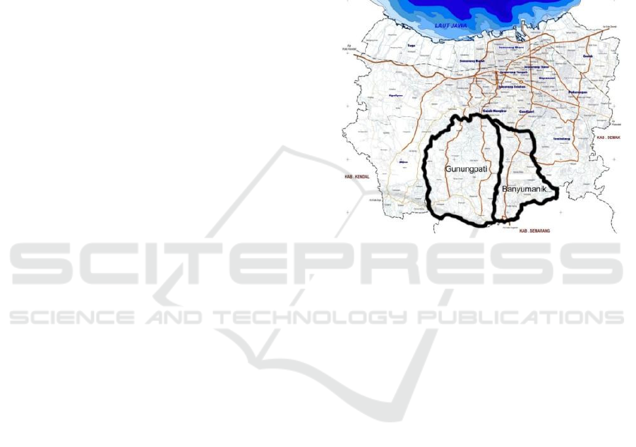
The research material is Banyumanik and
Gunungpati Sub-district Areas. This area is located in
urban fringe area of Semarang City with the
supporting function of the Semarang City Area below
as a conservation area. Of the two sub-districts, some
urban areas will be taken as a sample of research data
that can describe the physical condition of regional
development.
Figure 1: Location of research.
3 RESULTS
3.1 Overview of Banyumanik Sub-
district
Banyumanik Sub-district has an area of 2,509,084
Ha. Generally, the topography of the Banyumanik
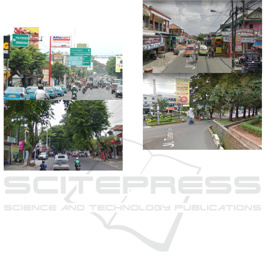
region is hilly and partly sloping. In terms of access,
Banyumanik Sub-district has become a strategic
pathway because it connects Semarang City Region
and the regions in central and southern Central Java
(direction to Solo or Magelang / Temanggung).
Besides that, the Semarang - Banyumanik toll road is
also quite strategic. The main trigger for regional
growth is the strategic path for business development
in the trade and services sector. This growth also
responds to the insistence of the core city which is no
longer able to sustain land needs for trade and service
facilities. Based on Regional Regulation No. 05 of
2004 concerning the RTRW of Semarang City,
Banyumanik Sub-district is included in BWK VII
with functions:
Settlement
Offices
Trade and services
Military Special Areas
EIC 2018 - The 7th Engineering International Conference (EIC), Engineering International Conference on Education, Concept and
Application on Green Technology
186
Mixed trade and services, settlements;
Conservation
Transportation.
Figure 2: Banyumanik Sub-district.
3.2 Overview of Gunungpati Sub-
district
Gunungpati Sub-district has an area of 5,399,085 ha.
The physical condition of hilly topography with
varying land heights in almost all regions. Viewed by
access to transportation, the Gunungpati area is
difficult to reach due to the steep and steep terrain.
The existence of Universitas Negeri Semarang
(UNNES) in Sekaran Village, to some extent
triggered the growth of the region. On the other hand,
growth is also supported by the presence of areas that
connect between Semarang City and Semarang
Regency and Kendal Regency. Based on Regional
Regulation No. 05 of 2004 concerning Semarang City
Spatial Planning (RTRW), Gunungpati District is
included in BWK VIII (City Area Section) with
functions as:
Conservation
Agriculture
Higher Education
Tourism / Recreation
Mixed trade and services, settlements
Settlements.
3.3 Landuse of Research Area
Figure 3: Gunungpati Sub-district.
The dominant land use in the research area was
the building of settlements and vegetation cover or
green open space, with residential buildings in
Banyumanik Sub-district wider (1,149.01 Ha) or
around 38.07% of the total area compared to
Gunungpati Sub-district with an area of 874.79 Ha or
around 16.20% of the area. The high percentage of
residential buildings in Banyumanik Sub-districts is
due to the fact that the region has a very strategic
location, supported by a complete and adequate
means of supporting life infrastructure and the
presence of several public buildings such as
Universities (UNDIP and Polines), Hospitals and
several other buildings that make the area it has had a
fairly rapid development in recent years.
The relatively flat topography in most of the
regions makes more and more potential land for the
development of built land. Generally, residential
buildings in the two sub-districts have two dominant
patterns, extending along the road and clustered in a
densely populated settlement and boarding house,
while the pattern of residential buildings in
Gunungpati Sub-district is more patterned along the
road, but also seen in groups regions such as in
Sekaran Village. In addition to the limited life support
facilities, a relatively undulating topography also
affects the development of residential buildings in the
region. Table 1 presents the types of land use at the
research area.
Study on Implementation of Green City Concept in the Suburbs of Semarang City based on Landuse
187
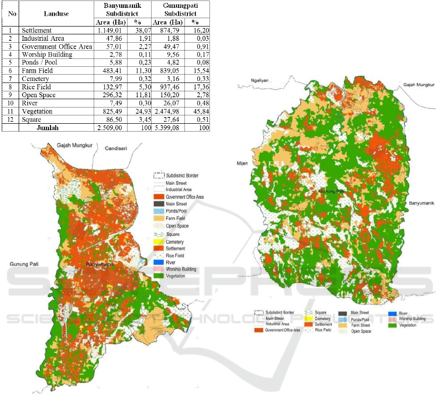
Table 1: Landuse of Banyumanik and Gunungpati Sub-
district.
Figure 4: Landuse of Banyumanik Sub-district.
Furthermore, the second largest area of land use is
vegetation cover / green open space, and the
vegetation included in this class includes mixed
gardens, public GOS, private GOS and forest areas.
Based on the results of the interpretation of the largest
vegetation cover / green open space in Gunungpati
Sub-district, 2,474.98 Ha or about 45.84% of the total
area, the vegetation cover and green open space in the
other two sub-districts have an area that is almost
equal to below 30% an area. Still maintained
vegetation / green space in Gunungpati Sub-district is
caused that most of the area is a protected area with a
fairly steep slope so that it is not easily converted into
built land. The area of vegetation in this area is the
main support of green open space in the Semarang
City with the Mijen Sub-district as a counterweight to
the microclimate and oxygen source of the
population. However, when viewed from the spatial
pattern, the distribution of vegetation / green space in
the area is not evenly distributed with a clustered
pattern so that there are not a few areas with densely
populated settlements but have low vegetation cover
such as in Sekaran Village.
Figure 5: Landuse of Gunungpati Sub-district.
In Banyumanik Sub-district, the area is relatively
low when compared to the total area, vegetation cover
/ GOS is 24.93%. Generally, vegetation / GOS
consists of urban forest, citypark, road border and
mixed gardens with elongated patterns. Referring to
Law No. 26 of 2007 concerning Spatial Planning, it
can be concluded that vegetation cover / GOS that
meets minimum broad standards is found in
Gunungpati Sub-district with an area of more than
30%.
4 CONCLUSION
The results of the research show that Banyumanik has
Banyumanik has a higher agglomeration rate of
Semarang City compared to Gunungpati, and has a
risk of environmental vulnerability.
EIC 2018 - The 7th Engineering International Conference (EIC), Engineering International Conference on Education, Concept and
Application on Green Technology
188

As an area that is more urban and with a high
density level, Banyumanik Sub-district requires
structuring towards the concept of a green city. The
steps that need to be taken include: integrated waste
management, the adoption of the concept of eco-
training, provision of pedestrian paths and bicycle
lanes, optimization of idle land as urban GOS,
encouraging the greening of private GOS, and the
application of green buildings in accordance with
standards. These efforts are expected to reduce the
city's burden due to environmental degradation as a
impacts of the city's development.
On the other hand, although Gunungpati
Subdistrict is characterized by rural areas, in its
development it tends to override aspects of regional
planning that have a green city concept.
Environmental degradation at urban development
points has begun, from building density, drainage
problems and inadequate urban infrastructure. Efforts
to implement the concept of a green city must also be
implemented properly. In addition, efforts to
overcome the adverse effects of increasing green land
clearing for new residential and business areas. Land
revitalization is absolutely necessary to prevent the
threat of disasters, such as: floods, landslides,
droughts and extreme climate change.
REFERENCES
Basri, A., 2008. Konsep kota hijau (kota hijau) sebagai
model perencanaan kota baru pesisir: Studi kasus
kawasan Sasa sebagai embrio pengembangan Kota
Ternate, Master Thesis, S2 Teknik Arsitektur,
Universitas Gadjah Mada, Indonesia.
Branch, M. C., 1996. Perencanaan Kota komprehensif
(Pengantar dan Penjelasan), Gadjahmada University
Press, Yogyakarta, Indonesia.
Ekaputra, Y. D., 2013. Implikasi Program Pengembangan
Kota hijau (P2KH) Terhadap Pemenuhan Luasan
Ruang Terbuka Hijau (RTH) Perkotaan. Semarang:
Prosiding SNST ke-4 Tahun 2013, Fakultas Teknik
Universitas Wahid Hasyim Semarang, Indonesia.
Kota hijau, 2012. Kota hijau Sebagai Solusi
Pengembangan Kota di Indonesia. acuired from
webite: http://greencityriau.com
Lynch, K., 1971. Site Planning, 2
nd
Edition, The
Massachusetts Insitute of Technology, Cambridge,
Massachusets, and London.
Kirmanto, D., Ernawi, I. S. & Djakapermana, R. D., 2012.
“Indonesia Kota hijau Development Program: an Urban
Reform”, The 48
th
ISOCARP Congress, Perm, Rusia.
Kuntjojo. 2009. Metodologi Penelitian. Diktat. Kediri.
Web:Http:// ebekunt.files.wordpress.com/2009/04/
metodologi- penelitian.pdf
Peraturan Kawasan Kota Semarang No. 14 Tahun 2011.
Rencana Tata Ruang Wilayah Kota Semarang Tahun
2011 – 2031, Indonesia.
Prihanto, T., 2012. Kajian Perubahan Spasial Kawasan
Pinggiran Kota Semarang Ditinjau Dari Rencana
Pembangunan Jangka Menengah Daerah (RPJMD)
Tahun 2010 – 2015. Penelitian Dasar: Universitas
Negeri Semarang, Indonesia.
Study on Implementation of Green City Concept in the Suburbs of Semarang City based on Landuse
189
