
Research on the Comprehensive Improvement and Planning of River
Courses in Mountainous Areas
Juan Dai, Wentao Lei, Miao He and Yinjun Zhou*
Changjiang River Scientific Research Institute, Wuhan, 430010, PR China.
Email: zhouyinjun1114@126.com.
Keywords
: Comprehensive improvement, planning, mountains areas, flood control, ecological management
Abstract: River is not only an important water conservancy facility, but also an important part of the ecological
environment. In this study, the comprehensive treatment plan of the Baoshi River in the mountain river is
taken as an example. According to the principle and layout of the comprehensive management of the river
basin, combined with the analysis of the current situation of the river, flood control, bank slope protection,
drinking water and irrigation water safety of the middle and lower reaches of the Baoshi River are
comprehensively controlled. Construction of related projects to ensure flood control and water safety for
residents. Through the comprehensive regulation of the river, the flood control standards of the cities and
towns and their infrastructure are further improved, the problems of flood control security for the people's
lives and property in the region and the economic development have been further solved.
1 INTRODUCTION
In recent years, the concept of ‘returning to nature’
(
Mei and Chen, 2015) has been put forward for river
regulation, and the concept of traditional river
management to modern river ecological
management has been formed. The river ecological
management pattern is divided into three types:
natural ecological river treatment, engineering
ecological river treatment and landscape ecological
river treatment (
Ma and Wang, 2008). According to
the control mode, the ecological river control is
more suitable for the river channel in the plain area;
the ecological river management of the landscape is
more suitable for the urban river course, and the
ecological river management of the engineering is
the treatment, it is more suitable for the river course
in the mountain area.
Mountain rivers have the characteristics of large
river slope, large flow rate, large sediment
concentration, strong scouring power, sudden rise
and fall of floods. Therefore, the key point of
mountain river regulation is flood safety, followed
by maintaining the stability of the embankment
(Laiet al., 2011). Using engineering measures to
protect the structural stability and safety of the river,
give full play to the natural advantages of the
mountain area, and maintain the ecological
environment of the river with appropriate section
type and ecological measures (
Huang and Fang, 2012).
Scholars have also carried out a great deal of
research on the ecological management of river
course in mountainous areas, especially the study of
river ecological restoration (
Nilsson et al.,1991),
based on various restoration techniques of various
targets (
Thyssen, 2000), and the study of river
ecological base flow (
Li, 2006). This study takes
Baoshi River as the research object, and carries out
comprehensive research on river channel in
mountainous area based on ecological management.
Baoshi River locates in Chuangwang Town,
Tongshan County of Xianning City, and it is the
third level tributary of Yangtze River Basin, the
drainage area is about 214km
2
. Baoshi River drain
into Hengshi River in N29°31′20〞and E114°38′08
〞,runs into the Yangtze River after draining into
Fushui through Daban Town, and going through
Fuchi Town in Yangxin County in the east. The
River has two origins, which are Taiyan Mountain in
the west and Jiugong Mountain in the east. Jiugong
Mountain locates in Tongshan County in Hubei
Province, which is in the middle of Mufu Mountain
on the border of Hubei and Jiangxi province, its
522
Dai, J., Lei, W., He, M. and Zhou, Y.
Research on the Comprehensive Improvement and Planning of River Courses in Mountainous Areas.
In Proceedings of the International Workshop on Environment and Geoscience (IWEG 2018), pages 522-528
ISBN: 978-989-758-342-1
Copyright © 2018 by SCITEPRESS – Science and Technology Publications, Lda. All rights reserved
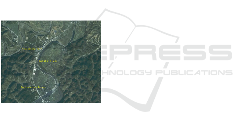
altitude is 1657m and is the highest peak of Mufu
Mountain. Taiyang Mountain locates in the middle
part of Mufu Mountain and is 45km from Tongshan
County. The altitude of Huanghejian is 1386m, and
is the second highest peak in the south of Hubei
province.
From the river system length and the area of the
basin, JitanRiver is the major water origin of Baoshi
River on the left,which joined Xialiang
RiverGaochao River and Dayuan River on the right
bank from the east side. The length of Baoshi River
is about 35km from southwest side to northeast side
along the drainage line, and its average gradient is
4.2‰. Chuangwang Town has rich water
resources,by the end of 2002, it has established 16
hydropower stations, and its total installed capacity
is 1.176×10
4
KW, and its annualgenerated energy is
2469.42×10
4
KW·h. Regional map of Baoshi River
see Figure 1 as follows.
Figure 1: Regional map of Baoshi River.
2 CURRENT SITUATION OF
WATERCOURSE
Accordingto the geomorphic features of the
watercourse and the boundary conditions of the
riverbed, the main streams of Baoshi River can be
divided into the upper, middle and down streams,
while the secondary power station of Baoshi River
and Baoshi River Power Station are taken as
boundaries.
The watercourse above the secondary power
station of Baoshi River is the upper stream, its full
length is 18.5km, and average gradient is 6.1‰. The
watercourse of the upper stream traverses in the
mountains along the watercourses on the upper
stream, and goes through Jitan village, Gaochao
village and Dayuan village. High Mountain is the
major landform on the upper stream, Natural
landscape area of Jiugong Mountain locates in the
right and its highest peak reaches to 1657m. Taiyang
Mountain is on the left and its highest peak is
1386m. The riverbed of the upper stream is undercut
valley, and its elevation is 587m~120m, the water of
the river flows rapidly, and has numerous sharp
turns. There are big stones in the river and the
riverbed has good anti-scourability. Meanwhile, the
upper stream has luxuriant plants and good facilities
for soil and water conservation. The sediment
accumulation of riverbed is not obvious, so it has
relatively stable riverbed and limited deformation
magnitude in general.
The middle stream is from the secondary power
station of Baoshi Power Station, its full length is
13.1km, and its gradient is 3.4‰. Low mountains
and hills are main landforms in the middle stream.
Generally, the plant area on the left and the elevation
of the ridge is about 150m. Hills are the major
landforms in the plant area on the right, and the
elevation is between 110m to 120m. The branch of
Jiepai River joins the stream on the left, and there is
a level sevenpower station. The plane modality of
the riverway in the middle stream is curve, and it
consists of a series of continuous curves. The
average width of the river channel is 60m, but partial
flood plain is as wide as 330m.
The water head of the second grade power
station of Baoshi River is 9.96M, its installed
capacity is 12.3 million KW, and its annual
generating capacity is 3.09 million KW.h. The
powerhouse locates on the west of the mountain that
is on the left bank of Baoshi River, the inlet of the
power station connects with the powerhouse through
channels. A part of water intaking is used for the
power generation, and some part of the water is used
as domestic water for residents in Chuangwang
Town. The tailwater of the power station join Baoshi
River at 0.5km in the downstream. According to the
on-site survey, the river channel sedimentation on
the upper stream of the power station dam, clayey
silt is the major sedimentations. Dry weeds are
floating on the water on the upper stream, and there
are even white trashes that flow from the upper
stream. Sedimentation is very serious in the inlet of
the power station, while the decayed leaves covered
the fence, and polluted the water quality of intaking
water.
Research on the Comprehensive Improvement and Planning of River Courses in Mountainous Areas
523

The middle stream of Baoshi River goes through
Baoshi Village and the riverway divides the Baoshi
Village into South and North parts. There is a
population of ancient dwellings, residential
buildings and ancestral temple are on the north bank,
the street is parallel to the river bank; one abandoned
commercial street is parallel to the river bank on the
south, the street is 3m in width and 150m in length.
The south of the commercial street is residential
area, and the road network is similar with the north
bank. The water surface is very broad and the water
flows very stably in this area. The width of the river
is about 100m, and the depth is nearly 1.5m in the
dry season. Ancient dwelling are on the two sides of
the river, and the residential buildings on the south
is 2m above the water surface without protection of
related projects. Some residential buildings on the
north bank were damaged, and newly established
concrete houses can be found in some places. The
residents on the two sides developed embankments
with cobblestones based on the natural dyke, but the
embankments are scattered. Meanwhile, the
embankments base is weak, so it is very easy to be
damaged by flood.
Five small overflow dams were established on
the middle stream of Baoshi River, which has high
water level and can be used to irrigation. The dam
body of the overflow dam is very low, and it is less
than 0.4m in height, so it is very poor in flood
protection and water storage. The dam body can be
damaged seriously by flood because of low
construction standard. Several dam bodies were cut
off in the middle, and lost its function for flood
protection and water storage, which has seriously
influences onfarm irrigation in nearby areas.
The area between Baoshi River Power Station
and the river mouth is the down stream, which
belongs to the administrative area of Liujialing
Village, and it is also the location of government
building in Chuangwang Town. The river consists of
a ‘U’ shape curve and straight area of the down
stream. The riverway is 4.1km in length and its
gradient is 2.9‰. The riverway goes through
Liujialing Village and the topographic relief on two
banks of the upper stream river changes slightly.
The river valley on two banks is broad, and
cultivated land is major form of land utilization on
two sides. The river mouth links with the flood plain
of Hengshi River, and a board river valley is formed.
The nearby flood plain is as wide as 750m. Gravel-
cobbles are the major materials of the riverbed the
diameter of the gravels that cover the riverbed
surface is about 5cm. Some areas of the riverbed
have bed rocks exposed out of the water along the
entire riverway, which forms shallow bank that cut
off the channels. The banks of the downstream
rivers are dominated by soil bank slopes, which are
wetlands on the banks of local rivers and the
vegetation grows.
3 RIVERWAY IMPROVEMENT
AND PLANNING
3.1 Planning and General Layout
According to the comprehensive management
principles and layout of the Baoshi River Basin, the
problems of flood control in the middle and lower
reaches of the Baoshi river section, the safety of
drinking water and irrigation water for the protection
of the bank slope, and the construction of relevant
supporting projects are constructed to ensure the
safety of flood control and the production and living
water. The overall layout is as follows:
3.1.1 Protect and Ensure the Flood
Prevention and Safe Production
The downstream of the Baoshiriver flows through
Liu Jialing village, which is the residence of
Chuangwang Town. Liujialing Village locates on
the left bank of Baoshi River, and it has occupied
about 1km of the water front. Most residential
buildings are constructed along the water, and
natural highland is used to avoid water or elevate the
house foundation manually to avoid water
influences, but no other prevention measures have
been taken. Therefore, the town might be flooded
once flood comes. Cultivated lands are around the
two banks of the downstream riverway, and silty
clay is the major component of the bank slope, the
elevation of the slop is 2m higher than the river bed.
During the period of serious flood, the water covers
the floodplain, and large areas of farmland are
flooded. Therefore, floodwall and flood control
dams are major projects along the riverway of the
downstream river. The flood prevention standard
shall be improved to ensure the safety of production
and living of residents.
IWEG 2018 - International Workshop on Environment and Geoscience
524

3.1.2 Restore Water Conservancy and
Irrigation Project and Construct
Water-saving New Village
The production and domestic water in Chuangwang
Town come from Baoshi River, the water supply
plant for the residents and secondary power station
of Baoshi River share the same water inlet. Because
of high water level of the dam, and slow flow
velocity, the sediment lifting of the riverbed become
worse, and the inlet was blocked. In this plan, it
aims to improve the water inflow capability of the
inlet and ensure the domestic water supply for
residents by clearing the silts of the riverway nearby
the secondary power station of Baoshi River.
The overflow dam of the Baoshi River was
damaged by flood seriously, and open channel was
used for irrigation, so the water loss is huge, and
water use efficiency is low. By restoring the
overflow dam of Baoshi River to adjust the layout of
open channel, strengthen anti-seepage measure,
improve the capability of main stream flow, and
then strengthen the recycle of tail water. Moreover,
corresponding supporting buildings will be
constructed, so as to improve the flood prevention
and water log control of the region.
3.2 Hydrological Analysis and
Hydraulic Calculation
3.2.1 Basic Hydrologic Data
There is currently no hydrological station along
Baoshi River. But along its trunk Stream of Hengshi
River, a hydrological station called Hengshi
Hydrological Station stands in Hengshi Town of
Tongshan County. The station was built in 1961 by
Hubei Provincial Department of Water Resources.
The drainage area is of 347km
2
. In 1966, after the
establishment of Fuli Reservoir, Hengshi
hydrological station was retired. In June of 1976, the
station was moved downstream, and was changed
into Hengshi Station II, with a catchment area of
426km
2
. It was located at E114°38'41", and N29°31
', responsible for testing precipitation, water level
and rate of flow. After investigation and analysis,
there is no large and medium-sized water
conservancy projects found at the upstream of the
station, so the data is consistent and representative,
can be used as the design basis for the hydraulic
calculation of Baoshi River.
Xiapu hydrological station is at the mainstream
of Xiapu River adjacent. The station is a national
base. The observation methods and data
reorganization all meet the requirements of
hydrological test, which is precise and reviewed year
by year, so it can be taken as the bench-mark station
for this project.
3.2.2 Flood Analysis
A. The characteristics of storm flood
Since the flood in this basin is all caused by storm,
according to the statistics of Hengshi Sation II,
heavy rain mainly happens from April to October
each year, and in some special year, it also may
occur earlier in March or later in November, of
which, June and July are the two months have
frequent heavy rains. The annual maximum 1h
rainfall usually occurs in April to October, of which
the highest frequency occurs from June to August.
The annual maximum 1d rainfall occurs in March to
August, and the highest frequency appears in June.
Hengshi River is a mountain stream fed by rainfall
and flood. The basin is rich in small streams and
floods. As it comes to flood season, the flood rises
and falls sharply in a short period with a mass flow.
The flood comes with storms, starting from April,
the most powerful in May and June, and the annual
maximum flood usually comes from April to July,
which is caused by plum rain season. So if with the
advancing or postpone of the plum rain season, or
due to extraordinary weather, the annual maximum
flood would probably advanced to March or
postponed to September. According to the peak data
measured by Hengshi Station II, the largest flood in
history happened in 1967, with a flow rate of 2100
m
3
/ s.
B. The maximum flood in history
According to historical surveys, there was a largest
flood in Hengshi River which occurred in June
1967, with a peak discharge of 2100m
3
/s. The data is
reliable. Considering that it happened in the actually
measured flood system, so the design flood will not
be handled as extra large value.
C. Design Flood of the Reference Station
(a)Design Flood in the bench-mark station
Hengshi Station II has a hydrological control area of
426km
2
. The study is based on the peak flow data
collected in last 31 years from 1961 to 2011( the
measurement was stopped from 1966 to 1980 and
the measurement from 1992 to 1993 is missing), as
well as the peak flow data of adjacent Xiapu Station
from 1964 to 1986. Considering that Hengshi
Research on the Comprehensive Improvement and Planning of River Courses in Mountainous Areas
525
Station II and Xiapu Station have almost the same
features of storms and floods for the two basins are
both rich in water, the missing data is supplemented
by 2/3 power of the area ratio of peak flow actually
measured in Xiapu Station. Along with the historical
records in 1967, it forms the maximum peak flow
series of Hengshi Station II from 1961 to 2011 (the
data of 1992 and 1993 are missing), a total of 48
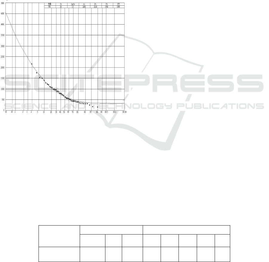
years. A frequency analysis is then carried out on
this series. With the help of P- Ⅲ line fitting
method, the design floods of Hengshi Station II
studied in this research is obtained. See Table 1 and
Figure 2
as follows.
Figure 2: Peak discharge frequency curve of Hengshi
Station II.
(b)Design Flood of the drainage basin of the
project
Design Flood of the drainage basin in Baoshi River
is calculated based on the below formula with the
values as flow. Design flood outcomes of Baoshi
River Basin see Table 2 as follows.
Q
design
=(F
design
/F
parameter
)
2/3
Q
parameter
Where Q -flow, m
3
/s; F-drainage area, km
2
3.3 Planning for River Regulation
3.3.1 Project Scope and Building Scale
According to the principle of control, the river
channel of 2.3km in the upper reaches of the two
grade power station of the Baoshi river should be
cleared, and 6.4km range of the lower reaches of the
river is governed by the requirements of the
ecological environment. Among them, the newly-
built roller compacted rockfill slope revetment on
both Banks of the upper reaches of Baoshi ancient
dwellings is 1.6km, and the left bank of the 3.2km
channel should built between the upper and lower
reaches of the highway bridge, the embankment is
the gravity type river embankment, the wall is 4 to
6m high, the 5m green belts which set up after the
wall. The other river embankments are the natural
rivers in the countryside, the soil slope is
consolidated and strengthened, and the greening
protective belt which planted. For treatment, the
protection standard is 10 years. Because the houses
are on the river bank, the local embankment is
protected by gravity retaining wall.
Five overflow dams were constructed in the
middle and lower reaches and Jiepai branch, which
are used for water storage and the improvement of
bridge landscape. The width of the riverbed is 28m-
87m, the height for water storage of the overflow
dam is 1.0-1.5m. The dam is an overflow gravity
dam and its weir crest is 1.5m in width, golden
silvering type filling is used on the dam body, and
C20 reinforced concrete that is 50cm in thickness is
used on the outer layer of the dam body, while
enrockment is used inside. The two dam abutment
enters the bank slope with the depth of 1.5m. The
upstream face of the dam body is a vertical face,
while the downstream face is a WES practical weir
face. C20 concrete apron with the thickness of 40cm
is set up for the riverbed, and the length is 10.0m.
Embankments planning in the middle and down
streams of Baoshi River see Table 3 as follows.
Table 1: Hengshi Station II design flood outcomes.
Item
parameters frequency(%)
Average
value
Cv Cs/Cv 2 5 10 20 50
peak
discharge(m
3
/s)
788 0.58 3.5 2120 1700 1380 1067 646
IWEG 2018 - International Workshop on Environment and Geoscience
526

Table 2: Design flood outcomes of Baoshi River Basin(m
3
/s)
Section Position
Frequency(%)
2 5 10 20 50
Secondary Power Station(CS1#)
985 790 641 496 300
Baoshihe Power Station(CS2#)
1281 1027 834 645 390
Confluence(CS3#)
1340 1073 871 673 408
Table 3: Embankments planning in the middle and down streams of Baoshi River.
Serial
Number
Geographic name
Design
flood
level(
m
)
Dike slope
elevation
(
m
)
Dike type
Length
(km)
1
Cheping ~Chuangwang highway
bridgein the upper stream (Baoshi
Ancient Dewelling)
92.86~91.12
93.76~92.1
2
Left
b
an
k
RCC slope
revetment
1.6
Right
b
an
k
RCC slope
revetment
2
Chuangwang highway bridgein the
upper stream (Baoshi Ancient
Dewelling)~ Chuangwang highway
bridge in the down stream(Liujiafan
Villa
g
e
)
91.12~80.36
92.12~81.3
6
Left
bank
Gravity
retaining walls
3.2
Right
bank
Soil slope
strengthening
3
Chuangwang highway bridge in the
down stream(Liujiafan)~
confluence of Baoshi
River
(
Wan
gj
iafan
)
80.36~79.99
81.36~80.8
9
Left
bank
Soil slope
strengthening
1.6
3.3.2 Project Grade and Standard
According to the ‘flood control standards’
(GB50201 - 94), and the he relevant provisions in
the ‘code for design of levee engineering’(GB50286
- 98), the grade of flood prevention and protection
project in the section of Baoshi Town is grade 4,
while the other sections is grade 5. According to the
service life of the civil synthetic materials, the
normal service life of the project is greater than 50
years.
3.3.3 Overtopping Elevation
According to the ‘standard’ provisions, the
overtopping elevation is confirmed based on the
levee crest of the design flood. The design flood is
once-in-ten-year level, and the flood level
is79.99m~92.86m. The design storm wave height,
damming, and free board elevation is
80.89m~93.76m.According to the above principles
and designs, the planning research of the middle and
lower reaches of gemstone river studied in this
project is shown in Table 3.
3.3.4 Main Engineering Quantity
According to the layout of the project, the length of
the river channel silting is 2.3km, and the length of
the RCC slope revetment is 3.2km, the length of
newly constructed gravity retaining wall is 3.2km,
and the length of the soil slope strengthening is the
6.4km. Besides, five overflow dams are constructed.
4 CONCLUSIONS
According to the relevant standards, river regulation
planning in Baoshi River conforms to the general
planning of Tongshan County and its flood
prevention plan, so it is feasible in technology.
Meanwhile, it has combined the regulation planning
of water and soil conservation as well as the water
ecology and landscape planning. The flood
Research on the Comprehensive Improvement and Planning of River Courses in Mountainous Areas
527

prevention and shore protection project is necessary
and urgent from the perspectives and requirements
to improve the flood prevention standard, reduce
flood damage, prevent the life and property of
residents along the river, speed up the urban
development and improve the environment. This
project is not only a life project that is related to the
economic development and living of residents in this
area, but also is an image project to improve local
ecological environment, invest in environment
protection and tourist environment, so the project
should be implemented as soon as possible and play
its positive role on these aspects.
ACKNOWLEDGEMENTS
Partial financial support of the work presented in
this paper from China’s National Natural Science
Foundation of China (No.51509014, No. 51579014
and No.91647117) are gratefully acknowledged.
REFERENCES
Huang Kaiwen and Fang Jianfei 2012 River Embankment
Design in Mountainous Area Zhejiang Water
Technology 7 38-39
Lai Yong, Shi Linxiang and Zhen Xuming 2011 Key
Problems and Countermeasures of Mountainous River
Ecological EmbankmentChina Rural Water
Conservancy and Hydropower9 142-144
Li Jia, Wang Yurong andLi Kefeng 2006 The Method of
Ecological Hydraulics for Calculating the Minimum
Ecological Water Requirement of River 37(10) 1169-
1174
Ma Yichao and Wang Xin 2008 Design Thinking of Plain
Ecological River Course Journal of Zhejiang Water
Conservancy and Hydropower College3 51-52
Mei Debo and Chen Zhongrun 2015 The Application of
River Ecological Management Concept to River
Regulation in Mountainous Areas The Water Industry
Market11 76-77
Nilsson C, Ekblad A and Gardfjell M, et al. 1991 Long-
term Effects of River Regulation on River Margin
Vegetation Journal of Applied Ecology 28 963-987
Thyssen N 2000Rivers in the EuropeanUnion:Water
Quality,Status and Trends //H.J.Nijland and M.J.R.
CALS.River Restoration in Europe.Netherlands
IWEG 2018 - International Workshop on Environment and Geoscience
528
