
A Simple Shadow Area Processing Method
Haiqing Wang
China Aero Geophysical Survey and Remote Sensing Center for Land and Resources,Beijing 100083,China.
Email: whq0705@126.com
Keywords: Remote sensing, shadow area, ratio analysis, image processing
Abstract: Shadow is an important factor that restricts remote sensing information extraction. How to use simple and
effective image processing method to display the remote sensing information of shadow area has been a
difficult problem in the field of remote sensing. In this paper, a simple ratio analysis method is applied to
study the shadow area remote sensing image processing, which shows the remote sensing information
hidden in the shadow area better. The method lays a good foundation for further remote sensing information
extraction. This method is simple and effective, not only can solve the problem, but also easy to operate,
even the non-remote sensing image processing professionals can also be used flexibly.
1 INTRODUCTION
Shadow is an important factor that restricts remote
sensing information extraction. How to use simple
and effective image processing method to display
the remote sensing information of shadow area has
been a difficult problem in the field of remote
sensing. There are many research findings about
shadow processing, in recent years. A shadow
processing method based on normalized RGB colour
model was proposed by Yang and Zhao (Yang and
Zhao, 2007).A shadow compensation method based
on linear stretching, smoothing and principal
component was proposed by Wang and Wang
(Wang and Wang, 2010). By improving the Wallis
filtering shadow compensation strategy, the ground
information in the shadow area was highlighted by
Gao et al. (Gao et al., 2012). The shadow vegetation
index SVI was constructed to discuss the problem of
image shadow removal by Xu et al. (Xu et al.,
2013).Combining the wave band regression model
and shadow vegetation index SVI can be effective,
according to Liu et al. (Liu et al., 2013). Gao et al.
(Gao et al., 2014) believe that in order to
compensate the model as the foundation, through the
mean brightness shadow and non-shadow region
statistics and variance, it is possible to use the
method of feature extraction and matching of
automatic acquisition of model parameters,
automatic compensation and shadow comprehensive
regional overall level of compensation and
compensation for the two level local window. Deng
et al. (Deng et al., 2015) explored the use of blue
light suppression algorithm and statistical
information of shadow homogeneity to compensate
for H, I and S components, respectively and
converted the results to RGB colour space to
achieve shadow compensation. Based on ArcGIS
Engine platform, Matlab and GDAL development
tools, Yang et al. (Yang et al., 2015) integrated
shadow detection and compensation systems
designed according to the shadow detection and
compensation algorithm of high resolution remote
sensing images. Shadow removal of remote sensing
images based on inhomogeneous regularized
texture-preserving was proposed by Fang et al.
(Fang et al., 2015). The shadow removal model of
traditional HSV space by integrating one step
information, based on it, a shadow removal
algorithm of moving objects based on reflectance
ratio invariants, was proposed by Zhang and Yang
(Zhang and Yang, 2016). Improvement of image
shadow tracking and elimination algorithm based on
texture loss least constraint was proposed by Yan et
al. (Yan et al., 2016). Methods of pattern recognition
and image enhancement are used to discuss the
problem of shadow removal by Zhao et al. (Zhao et
al., 2016). Methods used shadow extraction,
envelope removal, similar pixel search and shadow
brightness reconstruction to explore the shadow
Wang, H.
A Simple Shadow Area Processing Method.
In Proceedings of the International Workshop on Environment and Geoscience (IWEG 2018), pages 507-510
ISBN: 978-989-758-342-1
Copyright © 2018 by SCITEPRESS – Science and Technology Publications, Lda. All rights reserved
507
information reconstruction experiment of Landsat 8
OLI image in hilly area of southwest China were
proposed by Zhang et al. (Zhang et al., 2017).
Shadow removal algorithm based on improved
Gaussian mixture model and texture was proposed
by Wang and Zhang (Wang and Zhang., 2017). A
method of target detection and shadow removal
based on the combination of improved adaptive
hybrid Gaussian model and colour space was
proposed by Wang and Tong (Wang and Tong,
2013). These shadow removal methods are more
suitable for remote sensing researchers, and master
software professionals, however for remote sensing
interpretation and information extraction of
personnel engaged in the application of remote
sensing, these software are often not good, and need
a lot of energy to carry on the software
programming, it is also difficult to extract remote
sensing information of a shadow area. If a simple,
effective, easy to understand and easy to operate
shadow area processing method could be found; it
will solve the problem of remote sensing shadow for
interpreters and information extraction personnel.
2 AN OVERVIEW OF THE
STUDY AREA
The study area is located in the middle of Qinghai
Province, in the southeastern side of the Qaidam
Basin. It is a part of Kunlun mountain, Burhan
Budai Mountains in China, the highest peak of
which is 5000 meters above sea level. The study
area is located at an elevation of 4000 meters. Under
the action of plate movement, the ground surface
continues to uplift, the erosion is sharp and the
terrain is rugged where it is located at the southern
margin barrier of the Qaidam Basin. The remote
sensing image of the mountain slope often has
shadow, causing a lot of trouble to the remote
sensing information extraction and interpretation
work, need a simple and effective treatment method
of shadow zone.
3 REMOTE SENSING DATA AND
PRE-PROCESSING
In order to improve remote sensing image of shadow
area, the GeoEye-1 and Worldview-2 remote
sensing data of the study area were obtained (Table
1).
In order to ensure that the research work will be
carried out smoothly, first of all remote sensing data
quality was checked for the vegetation cover, the
amount of snow and ice, cloud cover, distortion, and
noise. Inspection shows that the remote sensing data
is characterized by rare cloud and snow, low
vegetation cover, no distortion, no noise (Table 2).
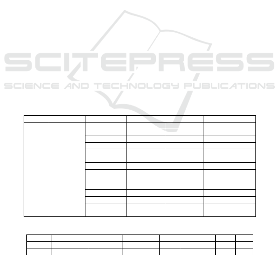
Table 1: List of remote sensing data and their characteristics.
Number
Data Type
Band Name
Band Number
Resolution(m)
Spectral Range(nm)
1
GeoEye-1
Pan
Pan
0.5
450-800
Blue
1
2
450-510
Green
2
2
510-580
Red
3
2
655-690
Near Infrared
4
2
780-920
2
Worldview-2
Pan
Pan
0.5
450-800
Coastal
1
2
400-450
Blue
2
2
450-510
Green
3
2
510-580
Yellow
4
2
585-625
Red
5
2
630-690
Red Edge
6
2
705-745
Near Infrared 1
7
2
770-895
Near Infrared 2
8
2
860-1040
Table 2: List of remote sensing data inspection
Number
Data Type
Vegetation
Snow and Ice
Cloud
Distortion
Noise
Strip
1
GeoEye-1
Very Sparse
No
<5%
Not Obvious
No
No
2
Worldview-2
Very Sparse
<5%
<5%
Not Obvious
No
No
IWEG 2018 - International Workshop on Environment and Geoscience
508
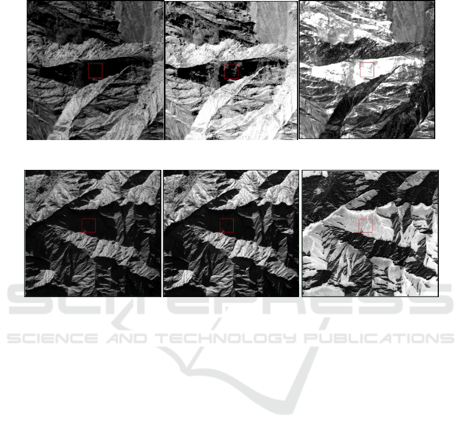
Figure 1: Image contrast of GeoEye-1 before and after data ratio operation (Left: B1; Middle: B3; Right: B1/B3).
Figure 2: Image contrast of Worldview-2 before and after data ratio operation (Left: B3; Middle: B8; Right:
B3/B8).
Remote sensing data pre-treatment includes raw
data normalization, image rectification, band
registration, image mosaic, data fusion, removal of
interference and tailoring of black edges. The
processed remote sensing data are more suitable for
subsequent research.
4 IMAGE PROCESSING IN
SHADOW AREA
In order to display remote sensing information
hidden in the shadow area, a variety of remote
sensing image processing methods had been tried,
and it was found that the method of using band ratio
operation is simple and effective.
Using GeoEye-1 remote sensing data to conduct
shadow area remote sensing image processing
method, it was found that after executing B1/B3
band ratio operation, the hidden information in the
shadow area can be displayed, which is convenient
for remote sensing interpretation (Figure 1).
Using Worldview-2 remote sensing data to
conduct shadow area remote sensing image
processing method, it is found that after B3/B8 band
ratio operation, the hidden information in the
shadow area can be displayed, which is convenient
for remote sensing interpretation (Figure 2).
5 CONCLUSIONS
It is concluded that by using GeoEye-1 and
Worldview-2 remote sensing data, B1 to B3 and B3
to B8 band ratios respectively can make the hidden
information in the shadow area appear, which makes
the interpretation of the remote sensing images
easier.
This method is simple and effective, not only to
solve the shadow problem, but also easy to operate,
even for the non-remote sensing image processing
professionals.
A Simple Shadow Area Processing Method
509

ACKNOWLEDGMENTS
China Geological Survey Project: national mineral
resources development environment remote sensing
monitoring (DD20160075, 121201003000172705),
national mine new restoration and treatment
monitoring in 2017 (DD20189805,
121201003000172718) support.
REFERENCES
Deng L, Deng M J and Zhang L S 2015 Optimization of
shadow detection and compensation method for high-
resolution remote sensing images J Remote Sensing
Technology and Application 30(2) 277-284
Fang Y M, Li B L and Wu Y J 2015 Shadow removal of
remote sensing images based on inhomogeneous
regularized texture-preserving J Journal of Computer
Applications 35(S2) 238-241
Gao X J, Wan Y C and Yang Y W 2014 Automatic
shadow detection and automatic compensation in high
resolution remote sensing images J Acta Automatica
Sinica 40(8) 1709-1720
Gao X J, Wan Y C and Zheng S Y 2012 Automatic
shadow detection and compensation of aerial remote
sensing image J Geomatics and Information Science
of Wuhan University 37(11) 1299-1302
Liu J, Xu Z H and Yu K Y 2013 Shadow detection and
removal method for remote sensing image in
mountainous and hilly area J Transactions of the
Chinese Society for Agricultural Machinery 44(10)
238-241, 237
Wang H R and Tong W 2017 Target detection and shadow
removal method based on the improved gaussian
model J Journal of Jiangsu University of Science and
Technology (Natural Science Edition) 31(2) 172-177
Wang Y and Wang S G 2010 Detection and compensation
of shadows in high resolution remote sensing images
using PCA J. Journal of Applied Sciences 28(2) 136-
141
Wang Y N and Zhang H 2017 Shadow removal algorithm
based on improved gaussian mixture model and
texture J Computer Engineering and Design 38(7)
1879-1884
Xu Z H, Liu J and Yu K Y 2013 Construction of
vegetation shadow index (SVI) and application effects
in four remote sensing image J Spectroscopy and
Spectral Analysis 33(12) 3359-3365
Yan F, Zhang J and Wu S D 2016 Improvement of image
shadow tracking and elimination algorithm based on
texture loss least constraint J Modern Electronics
Technique 39(27) 104-108
Yang J and Zhao Z M 2007 Shadow processing method
based on normalized RGB color model J. Opto-
Electronic Engineering 34(12) 92-96
Yang X W, Yang S W and Zhang L M 2015 Design and
development of the shadow detection and
compensation system for high-resolution remote
sensing images J Remote Sensing for Land and
Resources 27(3) 177-181
Zhang P and Yang Y X 2016 Multiple information fusion
of video moving target shadow removal algorithm J
Video Engineering 40(2) 59-64
Zhang T, Liao H P and Cui L L 2017 Mountainous
shadow information restoration based on the
continuum removed J Journal of Remote Sensing 21(4)
604-613
Zhao Y F, Ren H E and Hu J F 2016 Genetic algorithm
and homomorphic filter for log face image process J
Journal of Northeast Forestry University 44(8) 92-96
IWEG 2018 - International Workshop on Environment and Geoscience
510
