
The Minin
g
Area Land Surface Temperature Retrieval from
Landsat-8 Data
Chunsen Zhang
*
and Rongrong Wu
Xi'an University of Science and Technology, China.
Email: zhchunsen@aliyun.com
Keywords: Surface temperature retrieval, Landsat-8, mining area, Mono-window algorithm
Abstract: Taking the Shendong mining area as a research area, Landsat-8 data were used to retrieve the surface
temperature of the study area using the radiation conduction equation method, the image-based retrieval
algorithm(IB algorithm), the Mono-window algorithm(MW algorithm) and the single-channel algorithm(SC
algorithm) respectively. The data were validated by MODIS land surface temperature (LST) data,
comparing the similarities and differences between different algorithms. The results show that: (1) The
Mono-window algorithm inversion accuracy is the highest among the four surface temperature inversion
algorithms, which is the closest to MODIS LST data, followed by the radiation conduction equation, SC
algorithm and IB algorithm. (2) The retrieval results of bare soil and buildings are the best for the four kinds
of landform types, of which MW algorithm has the highest retrieval accuracy. (3) The MW algorithm
should be adopted for the retrieval of surface temperature based on Landsat-8 data in the mining area.
1 INTRODUCTION
The exploitation and utilization of mineral resources
provide the backbone for the economic construction
and social development of the society, and
inevitably cause great damage to the ecological
environment in the mining area (QIU and HOU,
2013). However, as an important hydrological,
meteorological and environmental parameter ,
surface temperature affects the exchange of sensible
and latent heat between Earth-gas and it has
important applications in many fields, especially in
the meteorology, hydrology, vegetation ecology and
environmental monitoring (Li et al., 2016).Surface
temperature is an important parameter in the
physical processes of the Earth's surface at the
regional and global scales and it also plays an
important role in the Earth-gas interaction (Hu et al.,
2015).Using satellite observations, thermal infrared
remote sensing images can quickly and easily obtain
large surface temperature data. The data are updated
quickly and the cost is low. Therefore, thermal
infrared remote sensing data is widely used in
surface temperature retrieval (Zheng and Zeng,
2011).Landsat satellite data has always been one of
the most important remote sensing data for retrieval
of surface temperature. In 2013, NASA successfully
launched the Landsat 8 satellite which has two
thermal infrared bands, the 10th and 11th bands. The
Landsat 8 data has more advantages than previous
Landsat series satellites on surface temperature
retrieval.
At present, the main methods of surface
temperature retrieval are the radiation conduction
equation method, the image-based retrieval
algorithm, the Mono-window algorithm proposed by
Qin et al. (2001) and the Single-channel algorithm
proposed by Jiménez-Muñoz et al (2003). As early
as 2004, Sobrino et al (2004) used Landsat 5 TM
thermal infrared data to compare the similarities and
differences among the radiation conduction equation
method, the Mono-window algorithm and the
Single-channel algorithm. In 2009, Fan Hui (2009)
also introduced the Landsat data retrieval algorithm.
In 2016, Windahl et al. (2016) also performed
surface retrieval using the radiation conduction
equation, Mono-window algorithm and Single-
channel algorithm. According to the different remote
sensing data and the actual situation of different
research areas, scholars at home and abroad have
proposed a variety of surface temperature retrieval
algorithms, as well as comparatively analyze several
Zhang, C. and Wu, R.
The Mining Area Land Surface Temperature Retrieval from Landsat-8 Data.
In Proceedings of the International Workshop on Environment and Geoscience (IWEG 2018), pages 489-495
ISBN: 978-989-758-342-1
Copyright © 2018 by SCITEPRESS – Science and Technology Publications, Lda. All rights reserved
489
surface temperature retrieval algorithms. However,
there are few studies on land surface temperature
retrieval of Landsat 8 data. In this paper, based on
the Landsat 8 data, using the Shendong mining area
as the study area, the results of the four surface
temperature retrieval algorithms are compared to
obtain the surface temperature retrieval algorithm
which is the most suitable for the mining area, so as
to facilitate the study of ecological environment in
mining area. It has great significance for
environmental assessment and ecological
reconstruction of mining areas.
2 DATA AND WORKFLOW
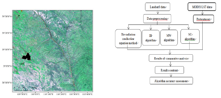
2.1 Study Area Summary
Shendong mining area is located in the junction of
Shaanxi and Inner Mongolia provinces. It was built
in 1985, and located in the transition zone between
the Mu Us Desert and Shaanxi Loess Plateau. Its
geographic range is (Latitude 38°52'-39°41' north,
Longitude 109°51'-110°46' east) and its central
geographic coordinates are (39°11'30'' N,
110°18'30" E). And its average elevation is 1.2km,
showing a general trend of low south and low north
(Figure 1). Annual precipitation is less and belongs
to the semiarid continental climate. Shendong
mining area belongs to a typical arid or semi-arid
desert area in northwestern China with low
vegetation coverage. In recent years, due to the
intensification of mining activities, the ecological
environment in the area has further deteriorated.
Figure 1: Location map of shendong mining area.
2.2 Data Introduction
On February 11, 2013, NASA successfully launched
the Landsat 8 satellite, reintroducing fresh blood
into the Landsat program that has taken 40 years.
The Landsat-8 carries two main payloads: the OLI
(Operational Land Imager) and the TIRS (Thermal
Infrared Sensor).The OLI Terrestrial Imager
includes nine bands with a spatial resolution of 30
meters, including a 15-meter panchromatic band
with an imaging wide band of 185x185km. The OLI
includes all the bands of the ETM + sensor and two
additional bands: blue band (band 1; 10.433-0.453
μm) Main applications in Coastal band observations,
shortwave IR band (band 9; 1.360-1.390 μm)
Includes Strong water vapor absorption
characteristics can be used for cloud detection;
Near-infrared band 5 and short-wave infrared band 9
are closer to the band corresponding to MODIS.
Based on the Landsat-8 data of Shendong mining
area from October 5, 2015, four surface temperature
retrieval algorithms are used: the radiation
conduction equation method, image-based algorithm,
Mono-window algorithm and Single-channel
algorithm to retrieval the surface temperature of the
study area. And land surface temperature (1km,
daily) product data of the same day were
respectively used for verification.Data preprocessing
includes: Radiation correction of the original image,
atmospheric correction, eliminating the impact of
the atmosphere on the image, image cropping,
cutting out the Shendong mining area. Work flow
chart is as follows(Figure 2):
Figure 2: Workflow diagram.
IWEG 2018 - International Workshop on Environment and Geoscience
490

3 SURFACE TEMPERATURE
RETRIEVAL
3.1 Surface Emissivity Calculation
Calculation of surface emissivity, using NDVI
threshold method to calculate surface emissivity (Li
et al., 2016):
0.004 0.986
V
P
(1)
Among them,
v
p
is the vegetation coverage,
which is calculated by the pixel dichotomy. The
principle is as follows (Li et al., 2016):
=
soil
V
veg soil
NDVI NDVI
P
N
DVI NDVI
(2)
In the formula, NDVI
soil
is the NDVI value of the
bare soil cover area; NDVI
veg
is the NDVI value of
the complete vegetation cover area; NDVI is the
normalized vegetation index, calculated according to
the following formula:
43
43
bb
NDVI
bb
(3)
In the above formula, b
4
is the near-infrared band
and b
3
is the red band, and the normalized vegetation
index is calculated according to the two bands.
Statistically calculated NDVI value, NDVI
soil
is
taken as the NDVI accumulated 5% and NDVI
veg
is
taken as 95% of the pixel value.
3.2 The Radiation Conduction
Equation Algorithm
The expression of surface temperature retrieval
according to the radiation conduction equation is
(Wu et al., 2016) :
2
1
ln 1
S
S
K
T
K
BT
(4)
In the above formula,
1
K
and
2
K
are the
calibration constants for the sensor.
2
1
=774.89
w
K
msr m
,
2
1321.08(K)K
;
B(T
S
) is blackbody radiance of temperature
calculated as follows:
1
S
LL L
BT
(5)
In the above formula, is atmospheric
transmittance, L
↑
is atmospheric up radiation, and L
↓
is atmospheric down radiation. The three parameters
can be found by entering the relevant parameters
through the NASA website (https://atmcorr.gsfc.
nasa.gov/);
L
is the radiation brightness of the
thermal infrared spectrum received by the sensor.
is the surface emissivity.
3.3 Image-Based Retrieval Algorithm
The Image-based Method (IB algorithm) is to invert
the DN value of the thermal infrared band to ground
bright temperature.
The IB algorithm calculates the surface
temperature as follows (Ding and Xu, 2008):
1ln
red
S
red
T
T
T
(6)
In the above formula, T
S
is surface temperature;
λ
is thermal infrared center wavelength; T
red
is
surface bright temperature which can be converted
to the surface bright temperature through the
radiation correction of the DN value of the thermal
infrared band.
c
h
2
1.438 10 mk
, ɛ is surface
emissivity.
3.4 Mono-Window Algorithm
Mono-window algorithm (MW algorithm) was
proposed by Qin Zhihao et al in 2001. The retrieval
surface temperature algorithm is calculated as:
6
11
a
S
aCDbCDCDTDT
T
C
(7)
C
(8)
The Mining Area Land Surface Temperature Retrieval from Landsat-8 Data
491

111D
(9)
In the above formula, ɛ is surface emissivity; T
6
is surface bright temperature; a and b are constants,
respectively -67.355351 and 0.458606; T
a
is the
average temperature of the atmosphere.
is
atmospheric transmittance. According to the
location of the study area, temperature and water
vapor, the calculation method can be calculated
according to the following formula (Li et al., 2016):
16.0110 0.92621 273.15
a
Tt
(10)
0.974290 0.08007
(11)
ω is atmospheric moisture content, the
calculation formula is as follows (Li et al., 2016) :
7.5
273.3
0.0981 6.1078 10 0.1697
t
t
RH
(12)
t is the average temperature of the atmosphere,
RH is the relative humidity. They can be obtained
through the China weather station network data.
3.5 Single-Channel Algorithm
The Single-Channel Method (SC-Algorithm) was
proposed by Jiménez-Muñoz (Jiménez and Sobrino,
2003) in 2003 and is calculated as follows:
1
123Ssen
TL
(13)
In the formula, ɛ is the surface emissivity; L
sen
is
the radiation intensity measured by remote sensor
for satellite height;
123
,, , ,
are intermediate variables, the
formula is as follows (Xu et al., 2015):
2
sen
s
en
T
bL
(14)
2
sen
sen
T
T
b
(15)
4
2
1
1
y
bC
C
(16)
Among them, T
sen
is the ground brightness
temperature, λ is the thermal infrared band center
wavelength; C
1
and C
2
are constants:
8421
1
1.19104 10Cwmmsr
,
2
14387.7Cmk
,
2
111 12 13
aaa
(17)
2
221 22 23
aaa
(18)
2
331 32 33
aaa
(19)
The parameters are shown in the following table
1 (Ding and Xu, 2006):
Table 1: Parameter values.
Parameter
Landsat
TM/ETM+
Landsat OLI
11
a
0.14714 0.04019
12
a
-0.15583 0.02916
13
a
1.1234 1.01523
21
a
-1.1836 -0.38333
22
a
-0.37607 -1.50294
23
a
-0.52894 0.20324
31
a
-0.04554 0.00918
32
a
1.18719 1.36072
33
a
-0.39071 -0.27514
4 SURFACE TEMPERATURE
RETRIEVAL RESULTS AND
ACCURACY ASSESSMENT
The retrieval results of the four surface temperature
retrieval algorithms are not much different, among
them the MW algorithm and the radiation
conduction equation method are the closest, the
surface temperature values of the study area
retrieved by the two algorithms are relatively high.
The result of SC algorithm is higher than the surface
temperature retrieved by the MW algorithm and the
radiation conduction equation algorithm (Figure 3).
The high-temperature areas are mainly distributed in
IWEG 2018 - International Workshop on Environment and Geoscience
492
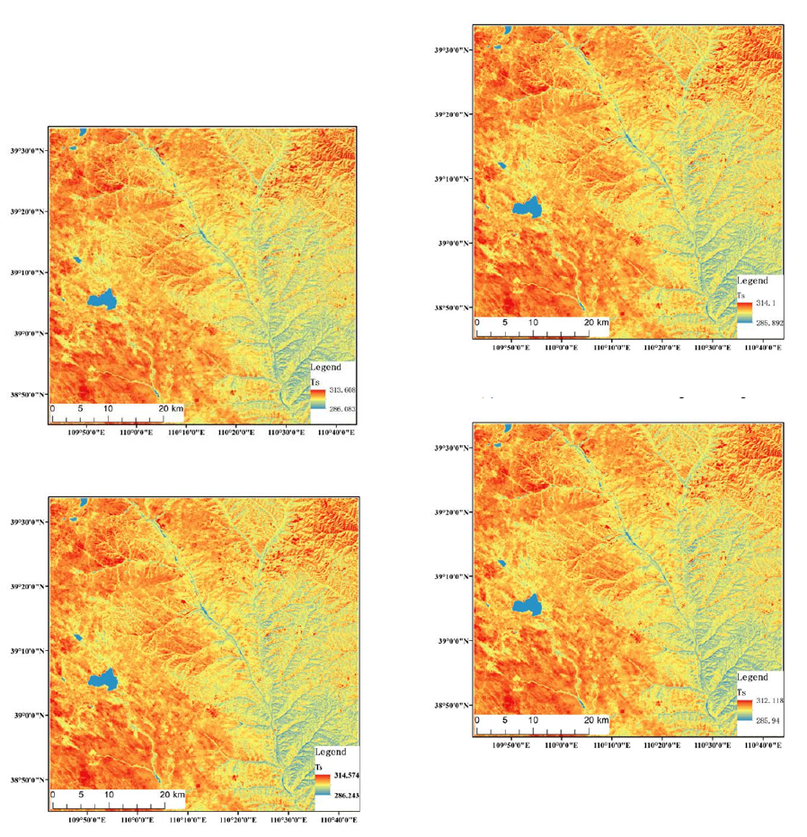
the north and west of Shendong mining area, the
middle-temperature areas are concentrated in the
central area, and the eastern areas with high
vegetation coverage are basically low-temperature
areas.
(a) MW algorithm
(b) SC algorithm
(c) The radiation conduction equation algorithm
(d) IB algorithm
Figure 3: Surface temperature distribution.
The results of four kinds of temperature retrieval
algorithm compared with MODIS LST after data
processing. The MODIS LST data needs to be
preprocessed first, and then the result of the surface
temperature retrieval algorithm is resample to 1 km.
The maximum, minimum, and average values of
each algorithm and MODIS LST data are calculated.
From the statistical results in Table 2, the
maximum, minimum and average of MW algorithm
are closest to MODIS LST temperature product data.
The four surface temperature retrieval algorithms,
The Mining Area Land Surface Temperature Retrieval from Landsat-8 Data
493

the surface temperature values of MW algorithm and
the radiation conduction equation algorithm are
relatively close. On average, the difference between
the Mono-window algorithm and LST data is about
0.03K; SC algorithm and LST data difference is
about 0.58K; Radiation conduction equation method
and LST data difference is about 0.19K; IB
algorithm is about 0.65K.
Based on four typical types of ground objects,
multiple sample points were selected to calculate the
average surface temperature. Combine four typical
ground objects, select multiple sample points, and
calculate the average of their surface temperatures.
On the whole, in October 2015, the temperature of
the water bodies in the four kinds of feature
categories was the lowest, the average is 5K lower
than other categories.The surface temperature of
bare soil was the highest relative to other features
with an average about 298K. The difference in
surface temperature between vegetation and
buildings was not large, the value is about 297K.
The four types of land surface temperature from
high to low: bare soil, buildings, vegetation, water.
Comparing and analyzing the results of four
surface temperature retrieval algorithms(Table 3),
the result of retrieval between water body and
MODIS LST data is about 3K, the surface
temperature retrieval result of bare soil is about 0.3K,
and the result of surface temperature retrieval is
0.5K, and the retrieval result of buildings is about
0.1K, of which the temperature of the water body is
the lowest and the temperature of the building is the
highest.
5 CONCLUSIONS
Based on Landsat 8 remote sensing images, using
Shendong mining area as the research area, the
surface temperature of the study area in 2015 is
retrieved by four methods of radiation conduction
equation, IB algorithm, MW and SC algorithm , and
the result is verified using MODIS LST data
respectively. As the result, the differences in the four
surface temperature retrieval algorithms were
analyzed and compared, and the surface temperature
of the mining area was studied. The following
conclusions were drawn:
1) According to the results of surface
temperature retrieval, the high temperature in
Shendong mining area is mainly distributed in the
north and the west, the middle temperature is
concentrated in the middle part, while the eastern
part with high vegetation coverage is basically in the
low temperature area, indicating that vegetation
cover degree and surface temperature were
negatively correlated.
2) Based on Landsat 8 data, the retrieval result of
the Mono-window algorithm in the four surface
temperature retrieval algorithms is closest to the
MODIS LST data. The retrieval result of the Mono-
window algorithm has little difference with the
radiation conduction method. And the gap between
the IB algorithm and MODIS LST data is the largest.
3) The results of surface temperature retrieval
algorithms of water bodies in four typical landform
types are lower than MODIS LST data. For
vegetation, only the SC algorithm has a slightly
higher surface temperature retrieval result than the
MODIS LST data. The accuracy of IB algorithm is
lower than any other ground objects. The retrieval
results of the MW algorithm and the radiation
conduction equation are similar. The MW algorithm
retrieval result is the closest to the MODIS LST data
with the highest accuracy. The surface temperature
of the four kinds of landform types from high to low:
bare soil, buildings, vegetation and water.
4) Based on the Landsat 8 data, the Mono-
window algorithm has the highest retrieval accuracy
in the four surface temperature retrieval algorithms.
Therefore, the Mono-window algorithm can be used
for practical application in the study of the
ecological environment or other issues in the mining
area.
Table 2: Comparison of the four algorithms of Landsat and the data temperature of MODIS product.
Algorithm Minimum(K) Maximum(K) Average(K)
MW 287.334381 309.588928 297.157173
SC 287.534119 310.457642 297.703065
Radiation conduction equation 287.178650 310.004150 297.309012
IB 287.131042 308.295410 296.465504
MODIS LST 290.339996 301.859985 297.120451
IWEG 2018 - International Workshop on Environment and Geoscience
494

Table 3: Comparison of surface temperature retrieval results with MODIS LST data.
Algorithm Water(K) Vegetation(K) Bare soil(K) Buildings(K)
MW 291.5670145 296.6649273 298.9086183 297.4721965
SC 291.914622 297.2018169 299.5086142 298.0196146
Radiation conduction
equation
291.5427124 296.810197 299.1072449 297.6238139
IB 291.1542784 295.9958007 298.131014 296.7675171
MODIS LST 294.502657 297.1853273 298.6946613 297.3679931
REFERENCES
Ding Feng, Xu Hanqiu 2006 An Algorithm and
Experimental Analysis of Surface Temperature
Retrieval Based on TM Thermal Wave Image [J]
Journal of Earth Sciences 8 (3) 125-130
Ding Feng, Xu Hanqiu 2008 A Comparative Study of
Three Land Surface Temperature Retrieval Algorithms
Based on Landsat TM Journal of Fujian Normal
University (Natural Science Edition) 24(1) 91-96
Fan Hui 2009 Comparative Analysis of Land Surface
Temperature Retrieved from Landsat TM Thermal
Infrared Bands [J] Remote-Sensing Information 1 36-
40
Hu DY, Qiao K, Wang XL,et al 2015 A mono-window
algorithm combined with Landsat 8 thermal infrared
data retrieval of surface temperature Journal of Remote
Sensing 19(6) 964-976
Jiménez‐Muñoz J C, Sobrino J A 2003 A generalized
single‐channel method for retrieving land surface
temperature from remote sensing data [J] Journal of
Geophysical Research Atmospheres 108(D22) 2015-
2023
Li Hengkai, Yang Liu, Lei Jun, et al 2016 Analysis of
surface disturbances in rare earth mining area based on
temperature difference Chinese Journal of Rare Earths
3 373-384
Li Z L, Duan S B, Tang B H, et al. 2016 Research
progress on retrieval method of surface temperature by
thermal infrared remote sensing Journal of Remote
Sensing 20(5) 899-920
Qin Z, Karnieli A, Berliner P 2001 A mono-window
algorithm for retrieving land surface temperature from
Landsat TM data and its application to the Israel-Egypt
border region[J] International Journal of Remote
Sensing 22(18) 3719-3746
QIU Wen-wei, HOU Hu-ping 2013 Study on Surface
Temperature Variation of Ecological Disturbance in
Mining Area Based on RS [J] Mining Research and
Development 2 68-71
Sobrino J A, Jiménez-Muñoz J C, Paolini L 2004 Land
surface temperature retrieval from Landsat TM 5[J]
Remote Sensing of Environment 90(4) 434-440
Windahl E, de Beurs K 2016 An intercomparison of
Landsat land surface temperature retrieval methods
under variable atmospheric conditions using in situ
skin temperature [J] International Journal of Applied
Earth Observation and Geoinformation 51 11-27
Wu Z G, Jiang T, Fan Y L, et al. 2016 Study on surface
temperature retrieval and analysis based on Landsat 8
data-A case study in Wuhan Journal of Engineering
Geophysics 13(1) 135-142
Xu Hanqiu, Lin Zhongli, Pan Weihua 2015 study on
several problems for retrieval of surface temperature
by single channel algorithm - a case study of landsat
series data [J] Journal of Wuhan University
40(4) 487-
492
Zheng Wen-wu, Zeng Yong-nian 2011 Comparative
Analysis of Multi-source Remote Sensing Data
Retrieval Algorithms for Surface Temperature Journal
of Earth Sciences 13(6) 840-847
The Mining Area Land Surface Temperature Retrieval from Landsat-8 Data
495
