
A Remote Sensing Biogeochemical Survey in and around the
Linghou Cu- polymetal Deposit, Southeastern China
Ling Han, Chengyan Du
*
School of Geology Engineering and Geomatics, Shaanxi Key Laboratory of Land Consolidation and Rehabilitation,
Chang’an University, Middle-section of Nan'er Huan Road, Xi’an, 710064, China.
Email: dcychdedu@163.com.
Keywords: The Linghou deposit, biogeochemistry, the OLI image, foliage
Abstract: Using the Landsat 8 imagery and the field- measured vegetation spectra, a biogeochemical survey in the
Linghou ore field of eastern China was conducted. Findings indicated that no vegetation anomalies were
observed in the 5 to 4 ratioing image. From the perspective of spectral feature, plants within the Linghou
diggings, especially at the tailings pond and wastewater pool, “grow worse” than at the peripheries,
although several individual exceptions behave against this trend. Thus we should not ignore the local
pollution which might be a valuable cue for the concealed ore- bodies or ecological destruction.
1 INTRODUCTION
Remote sensing technology relies mostly on the
capability of the sensor to register spectral
signatures and other geological features related to
mineral deposits (Cavalli et al., 2009). The
identification of sites with likely occurrence of
hydrothermal alteration is a positive clue for
existence of associated ore minerals. Nevertheless, it
is not providing a necessary spectral resolution to
identify specific minerals because of the broad band
configuration of TM/ETM+, particularly in SWIR.
The Linghou deposit surveyed in this paper is
located in northwestern Zhejiang province,
southeastern China, widely covered by vegetation
even in winter, but abundant in copper- polymetal
deposits. Because of the very dense cover of regolith
and vegetation, an alternative approach of survey
that reduces the effect of this thick coverage must be
developed in order to expose the alteration zones
and the anomalies associated with the concealed ore
body (Sabins, 1999).
According to (
Sims and Gamon, 2002), a series of
vegetal physiological and ecological variation, e.g.,
leaf temperature, chemical component, pigment and
water content, etc., may occur in response to ore
geochemical anomaly coming from rocks and soils
on which plants growth heavily relies. Normally
such a toxic action caused by metal poisoning of
plants and/or other ecological stresses is twofold: i)
The red- shift and/or blue- shift, e.g., chlorophyll
normally has a significant absorption within the red-
spectral region, while vegetal mesophyll has a
remarkable near infrared scattering, and the red-
edge appears in between. Generally those poisoned
leaves in gold ore- field have a bluely shifted red-
edge position (Kooistra et al., 2004). In addition,
spectral red- shift associated with a declined content
of leaf water due to contamination of heavy- metals
also occurs. ii) Relative to the healthy canopy,
poisoned vegetal leaves may always have higher
brightness in the images. Due to a very thick
sedimentary- vegetation cover in this area,
concealed rocks and deposits have become the focus
of mineral exploration; and in this regard, the study
on plant spectrum and its link to (environmental or
metallogenetic) geochemical anomalies may make a
particular contribution, although these
characteristics are just an indirect reflection of
mineral occurrence and environmental destruction.
From the above, the objective of this article is to
conduct a remote sensing data- driven
biogeochemical survey in Linghou ore field, eastern
China.
Han, L. and Du, C.
A Remote Sensing Biogeochemical Survey in and around the Linghou Cu- polymetal Deposit, Southeastern China.
In Proceedings of the International Workshop on Environment and Geoscience (IWEG 2018), pages 273-282
ISBN: 978-989-758-342-1
Copyright © 2018 by SCITEPRESS – Science and Technology Publications, Lda. All rights reserved
273
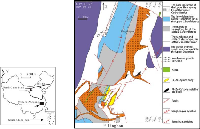
Figure 1: Geological sketch map of the Linghou polymetallic deposit.
2 GEOLOGICAL SETTING
The Linghou deposit (119°11′45″E, 29°29′30″N) is
located in the western Zhejiang province of China. It
is a medium- scale Cu- Pb- Zn deposit whose
genesis type is known as the hydrothermal reworked
deposit, as shown in Figure 1. The surrounding
strata of this deposit are mainly upper Devonian and
middle to upper Carboniferous along with the
general strike of NE- SW. There are two ore blocks
in Linghou: Songkengwu and Linghou (Tang et al.
2015). Typical calc- silicate (skarn) alteration can be
only found in the Songkengwu ore- field. Phyllic
alteration characterized by disseminated sericite and
quartz, with minor pyrite and chalcopyrite is well
developed within the granites. Silicification
characterized by quartz in ores or quartz + pyrite +
chalcopyrite veins in strata and granites is closely
linked to Cu- Au- Ag mineralization (Zhang et al.
2013). The carbonate alternation, characterized by
earlier recrystallization of dolomite + calcite
associated with the Cu- Pb- Zn minerali- zation, and
later calcite clusters in a hydrothermal calcite cave
near the ore- bodies, and calcite (± galena)
veins/veinlets across the ore and granites, is also
quite common.
3 DATA COLLECTION AND
PRETREATMENTS
The multispectral image was collected from Landsat
8 OLI_TRIS digital products (spatial resolution: 30
m) that are freely downloadable from
http://glovis.usgs.gov/. Its Row/Path is 40/119, the
time of acquisition is 14-04-2013. Later in Mar.
2016, a series of data were collected from vegetation
leaf samples in and around the mine area. The
sampling location is threefold: 1, sampling within
the mine excavations; 2, sampling within the
peripheral or background area relative to diggings,
acting as a control group; 3, sampling in one or more
kindred deposit (s) nearby in order to make a
contrast. Using FieldSpec®4 HI- RES spectrograph,
the reflectivity curve of dozens of leaf samples were
tested in- situ. The spectral measurement of foliage
adhered strictly to the user’s guide of this apparatus.
The basic approach of data quality control is to do
radiometric calibration by keeping the probe
vertically orienting the horizontally placed
whiteboard which is an approximate Lambertian
reflector with a fixed and known reflectivity
(Hatchell, 1999). Particularly, if the weather
IWEG 2018 - International Workshop on Environment and Geoscience
274
condition was not as good as expected, the
frequency of calibration must be doubled— every
two minutes. Conversely, it would be the best if a
100% reference line of reflectivity could be obtained
in sunny days.
Several pre- treatments, like imagery cutting,
radiometric calibration, atmospheric correction, and
orthorectification were carried out. At the same time,
waters with NDVI (Normalized Difference
Vegetation Index) between -0.079 and 0.05 were
erased for subsequent analysis, which accounts for
about 27.19% of the total area. There is no need to
mask other objects like settlements,
(concrete/asphalt) roads, factory buildings, etc., for
they are too small to extract and have limited
influence on the analysis.
4 SPECTRAL ANALYSIS OF
VEGETATION COVER
4.1 Spectral Analysis
(Zhao et al. 2017) discovered that on the 1: 200000
stream- sediments geochemical map, there is a
significant copper (Cu) - polymetal anomalous zone
lying in and around this studied area, e.g., copper
content in its concentration center (119°11′47.88″E,
29°29′05.07″N) reaches up to 3358×10-6 ppm,
nearly 120 times higher than copper clarke number
(Rudnick and Gao, 2003). According to (Gan and
Wang 2004), a significant decline of chlorophyll
pigment is the most obvious visual sign of
vegetation poisoned by ore metals. In this respect, it
is believed that the band combination 5, 4 and 3 of
Landsat 8 OLI is typically applied for vegetation
analysis, and seemingly, intense red color represents
vigorous growing plants producing a lot of
chlorophyll, while lighter shades of reds are still
vegetation, but may either be mature trees/plants or
dead, unhealthy plants. Unfortunately, the composite
results seem not so ideal: most light red shades are
actually montanic shadowed outcrops, or to a lesser
extent sparse vegetation areas (Ghasemloo et al.,
2011). A similar scenario can apply to the NDVI or
band 5 to 4 ratioing imagery.
In the visible wavelengths, there are several
peaks of spectral absorption and reflection (e.g. a
blue trough at ~480 nm, a red trough at ~680 nm,
and a green peak at ~550 nm), sensitively associated
with foliage content of chlorophyll. The OLI band 5
at NIR has a striking platform of reflection, relative
to any other peaks of reflection between 1400 and
2500 nm, whose average reflection is normally
greater than or equal to ~70% and related to
moisture content. Inasmuch the 5 to 4 ratioing OLI
image should play a role extracting biogeochemical
anomalous information relating to metal toxic action.
In SWIR: OLI band 6 (1560~1660 nm) and band 7
(2100~2300 nm) are quite sensitive to foliage
moisture content and mesophyll cellular structure.
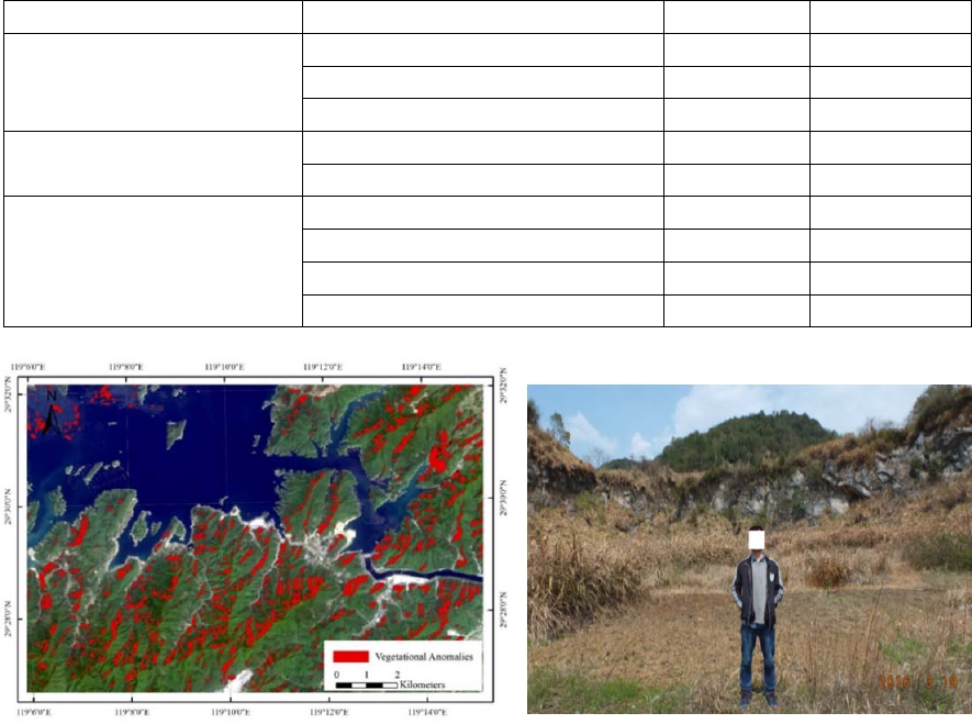
Figure 2 shows the darkest pixels in the OLI 5/4
ratio image, which, in theory, represents the
unhealthy vegetation. But in reality, they are just a
reflection of hill- shaded areas.
According to (Tong 1988), the Linghou mine is
considered to be a sedimentary- transformed
stratabound type. The syngenetic sediments may be
rich in Cu and other ore metals, but far from mineral
industrial grade. The Cu- polymetal- enriched sandy
shale layer is located mainly in -50 m and deeper
underground.(Cheng et al. 2012) pointed out that the
covering layer plays an essential role in shielding
and attenuating ore elemental migration, so that the
deep- rooted geochemical anomalies and metal-
logenesis exhibit only gentle and low grade
anomalies at the surface. However, due to a special
geochemical property, it is reported that Cu
abundance in soils at the upper part of the copper
deposit comes up to n000 ppm, which can be used
for secondary- halo prospecting (Liu et al., 1980).
Also local edaphic geochemical or vegetal
anomalies related to ore (Jiang et al., 2002) in
Linghou mine were confirmed (Yang et al., 2009).
Table 1, e.g., shows that the average abundance of
Cu in the Linghou diggings is significantly greater
than normal 5 ppm. As the relevant anomalies
cannot be exposed in Figure 2, so we have to turn
our focus to local and limited stressing phenomena
related to mine pollution, which is probably beyond
the monitoring ability of OLI imagery.
4.2 Vegetational Hyperspectral
Analysis
Although the vegetational coverage severely
masks/alters surface signals related to metallogenic
alteration and environmental deterioration, we
cannot exclude the possibility that by feat of spectral
sampling under similar illumination conditions,
vegetation information affected more or less by
various stressing agencies, and hence could act as an
indicator serving to get some specific anomalies
A Remote Sensing Biogeochemical Survey in and around the Linghou Cu- polymetal Deposit, Southeastern China
275
associated with mineralization in this area (Ma, 2000).
Table 1: The biogeochemical anomalies (concentrations of Cu and Zn in the plant leaves) in the Linghou and adjacent
Fuyang mining areas
a
.
Site Species Cu (mg kg
–1
) Zn (mg kg
–1
)
Residue sand place
Polygonum lapathifolium 150.2 505.6
Alternanthera sessilis 220.3 280.2
Eclipta prostrata 125.7 525.6
Farmland
Siegesbeckia glabrescens 190.1 95.4
Eclipta prostrata 235.4 750.4
Old mining area
Elsholtzia splendens 687.0 530.3
Rumex acetosa 530.0 530.3
Artemisia lavandulaefolia 198.6 372.5
Viola diffusa 606.4 585.6
a
After (Jiang et al., 2002).
Figure 2: The darkest colored areas in the OLI 5/4 ratio image,
namely the so- called vegetation anomalies. The relevant
threshold was determined by visual interpretation.
Figure 3: The sampling position P-2 at the periphery
of mine (29°29′16.56′′N, 119°11′ 41.76′′E). The main
lithology in this profile is carbonate- rock formation
(C2h), within this limestone wall no conspicuous
quartz mines and granitic apophyses were found. Here
the withered Miscanthus floridulus leaves were
collected for spectral analysis.
4.2.1 Phyllostachys Pubescens
Phyllostachys pubescen is one of the most important
cash crop in western Zhejiang province, but most
phyllostachys pubescens in later March are not in
their vigorous growth period, and many leaf edges
look still withered yellow. Four samples of
phyllostachys pubescen leaves were collected in
three sites. Two of them are at the mine (noted as PP
at O-1, and O-2), while the other two acted as the
comparative samples, as shown in Figure 3, are at
the periphery of mine (PP at P-1, and P-2). P-1 is
closer to the diggings than P-2. O-1 is at a small
catchment basin (29°29′17.04″N, 119°12′5.69″E),
and it was sampled close to the surface runoffs,
ensuring that the plants root system nearby can
absorb enough ore metals related to mineralization.
O-2 was collected at 29°29′21.19″N,
119°11′52.34″E. P-1 was tested at 29°29′21.06″N,
119°12′4.87″E. This site is on a hillside adjacent to
the mining area, and there is no surface runoff, ore-
bearing quartz veins and outcropped bed- rock
IWEG 2018 - International Workshop on Environment and Geoscience
276
nearby. These samples are fresh and plausibly
healthy leafage, leaving out partly withered or newly
transplanted plants. The weather condition during
test was cloudy to sunny.
As seen in Figure 4, the reflectance curves of
these 4 samples are similar in shape but distinct in
numerical magnitude, so spectral ratioing (or
derivative) is the best way to eliminate these effects.
For example, the average of foliage reflectance
between 850 and 880 nm, which is just the spectral
region of band 5 of an OLI image, is noted by B5
here; while the average between 640 nm and 670 nm,
namely the spectral region of band 4, is noted as B4
here; and the ratios of B5 to B4 of PP at O-1 is 8.12,
O-2 is 7.18, P-1 is 10.78, and P-2 is 6.84.
Apparently, the growth conditions of O-1 and O-2 in
diggings site are inferior to P-1; the phyllostachys
pubescen tree at P-2, however, grows in a little pile
of regosol within a small limestone sink- hole; so it
seems that the subalimentation, not the biotic stress
associated with ore contamination, may be
responsible for its lower value of B5/B4, which is in
accordance with (Jiang et al. 2013) report that
calcareous soils are characterized by
neutral/slightly- alkaline chemistry, thinner soil
layer, lack of available moisture, and etc., and few
wood species in them could grow well. Additionally,
(Li 2007) pointed out that due to polymetal stressing,
foliage reflection within 550~680 nm must be
enhanced significantly, that is why the reflectivity of
PP at P-1 and P-2 seems low.
Figure 5 further demonstrates the 1st order
derivative reflectivity between 680 and 750 nm: the
derivative of PP at P-1 reflectivity peaks at 719 nm,
known as the red- edge (Rock et al., 1988). Relative
to P-1, there seems a significant blue- shift of PP
red- edges at O-1 (701 nm) and O-2 (702 nm). PP
red- edge at P-2 is 700 nm. The slopes of the red-
edge are 0.0073 (O-1), 0.01093 (O-2), 0.005344 (P-
1) and 0.008896 (P-2), respectively, and PP at P-1
therein is the most gentle one. Actually, variation in
chlorophyll and carotenoid concentrations, in
addition to a buildup of additional pigments such as
tannins, may occur within leaves in response to
stress like heavy- metal pollution in the mining area,
and a blue- shift phenomenon may always act as a
diagnostic signature helping to identify the
biogeochemical damage caused by metallic stress
agents (Ninomiya et al., 2005). However, due to a
relatively small amount of spectral shifts (versus a
relatively larger spectral resolution of the
spectrograph), the observation error of discrete
spectra, and the spectrum rebuilding error, the red-
edge position are not so accurate sometimes, and
thus the utilization of this parameter must be
considered with cautions.
Another important parameter describing
vegetational anomalies is the so called “band-
depth”. As displayed in Figure 6- a, taken a foliage
sample at O-1 as instance, the reflectance with
continuum removed is noted as R’, and the band-
depth (D) at each point is calculated by D = 1 - R’
(Sanches et al., 2014). Meanwhile, in order to
eliminate the effects of topography, landforms, and
atmosphere, and for ease of comparison, normalized
band- depth Dn was further worked out by Dn = D /
Dc, where Dc is the band- depth of the central band,
which, in this work, is assigned the maximum of D
within a wavelength range of 350 to 1500 nm. In
this way, a continuum- removed reflectance curve is
normalized to a range of 0~1.0 that can enhance the
vegetal absorption and reflection spectrum. In
Figure 6, only the first three peaks of absorption are
taken into account in this paper, the first two
appearing in visible region: the blue trough and the
red trough, and the other one developing in near-
infrared range and reflecting foliage moisture.
Because of the blue- or red- shift possibly existing,
the depths and position of these peaks may not be
fixed.
As listed in Table 2, for the first peak, the band-
depths of PP at O-1, O-2, and P-2 are significantly
greater than at P-1, implying a deepened trough of
absorption; also, there is a blue- shift of PP from P-1
to O-2 and P-2. For the third peak, PP at O-2 and P-
2, relative to P-1, seem shifted bluewards, and actual
band- depths of O-1, O-2, and P-2 are much deeper
than P-1. This feature seems not completely
consistent with the phenomena that foliage badly
stressed by metals may have a saliently shallowed
band- depth.
A Remote Sensing Biogeochemical Survey in and around the Linghou Cu- polymetal Deposit, Southeastern China
277
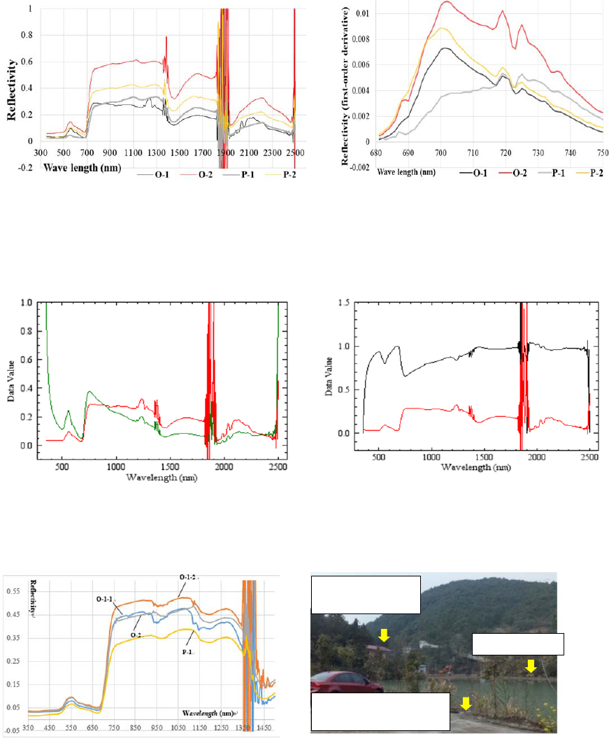
Figure 4: Spectral curves of reflectance of four phyllostachys
pubescen leafage Samples. Note that there is a drastic
fluctuation around 1900 nm, which may have something to do
with the illumination conditions and the surroundings like
breeze.
Figure 5: The 1st- order derivative reflectivity
(680~750nm) of 4 phyllostachys pubescen samples.
Figure 6: (a) The reflectivity curve of sample O-1, the red
curve: initial reflectivity curve (for both (a) and (b)), and
the green one: the continuum- removed curve of
reflectivity.
Figure 6: (b) Normalized band- depth of O-1 (the black
line).
Figure 7: Spectral curves of reflectance of four fir leafage
samples, and the corresponding sample description is seen
in the context.
Figure 8: The central position of sampling sites of O-1, O-
2 and O-3.
The site of O-3
The site of O-1, nearby
a mine- wastewater pool
The site of O-2,
nearby a dressing
IWEG 2018 - International Workshop on Environment and Geoscience
278

a
Note: The average of foliage hyperspectral reflectance between 850 and 880 nm is noted as band 5 (also the spectral range of Band 5 of an
OLI image), while the average between 640 and 670 nm, namely the spectral range of Band 4 of an OLI image, is noted as B4, and the
“band- ratioing 5/4” is actually a ratio of B5 to B4, no spectral anomalies can be observed in the image; or the relevant anomlies are
submerged into the hill- shaded areas, and hence indistinguishable. O-1, 2, 3 and P-1, 2 stand for different sampling sites, see context for
the positions for O-1, O-2, P-1 and P-2. O-3 is at 29°2 9′21.06′′N, 119°12′4.87′′E. WL is short for “Wave- length”, and NU is short for
“name known”, NU-1 therein is a newly grown leaf. Due to my limited professional knowledge on phytology, some samples were unable
to be identified in the open air, most of them, however, were collected from local arbor species. MF- miscanthus floridulus, IC- incense
cedar, OT- osmanthus tree, MP- masson pine, PP- phyllostachys pubescen, CT- camphor tree, M- moss, F- Chinese fir. Besides, peak1:
between 350nm and 557nm, the maximum value of normalized band- depth and the wavelength it corresponding to; peak 2: between 558
and 750, the maximum of band- depth normalized and the wavelength; peak 3: between 1400 and 1500nm, the maximum band- depth and
its position of wavelength.
Table 2: The band- depth at three troughs of absorption of all the foliage samples in Linghou mine
a
.
Site Species
Band- Depth
“Band 5/4”
The red- edge
WL peak-1 WL peak-2 WL peak-3 Slope WL
G
R
O
U
P
I
0-3 NU-1 550 0.948 759 1 1650 1.051 1.164 0.002 720
0-3 MF 490 0.975 678 1 1454 1.011 3.481 0.013 696
0-3 IC 502 0.986 676 1 1453 1.006 3.706 0.004 719
0-2 M 498 1 678 1 1459 1.006 5.048 0.007 695, 696
0-1 MF 498 0.957 679 1 1368 1.035 5.292 0.008 721
P-1 Arbutus 505 0.999 680 1 1457 1 5.529 0.006 719
0-2 M 440 0.992 679 1 1459 1.002 5.665 0.009 696
0-1 MF 494 0.987 675 1 1456 0.999 6.423 0.023 719
P-2 PP 493 0.981 675 1 1454 0.990 6.742 0.009 700
0-3 OT 497 0.983 675 1 1458 1.001 6.925 0.015 719
0-3 PP 501 0.977 678 1 1458 0.992 7.102 0.011 701, 702
G
R
O
U
P
Ⅱ
Site Species WL peak-1 WL peak-2 WL peak-3 “Band 5/4” Slope WL
0-1 PP 499 0.933 677 1 1461 0.987 7.727 0.007 701, 702
0-2 NU-2 496 0.977 678 1 1460 1.002 8.062 0.020 701
0-1 OT 502 0.994 675 1 1463 1.001 8.870 0.010 719
0-2 F 495 0.978 675 1 1459 1.001 8.956 0.010 719
0-1 F 497 0.999 672 1 1356 1.063 9.089 0.011 719
0-2 NU-3 496 0.992 676 1 1452 1 9.497 0.013 719
0-3 MP 496 0.984 673 1 1458 1.004 9.810 0.014 719
P-1 PP 500 0.890 673 1 1460 0.892 10.650 0.005 719, 725
P-1 F 492 0.998 675 1 1453 1 10.851 0.007 719
0-1 F 498 0.988 674 1 1360 1.511 10.852 0.010 721
0-3 NU-4 498 0.994 674 1 1456 0.999 10.922 0.014 701
0-1 NU-5 498 0.994 673 1 1455 1 11.070 0.013 719
0-2 CT 499 0.973 676 1 1460 0.990 11.115 0.013 719
P-1 OT 502 0.991 678 1 1457 1.003 11.473 0.012 719
0-1 MF 498 0.999 671 1 1399 1.408 11.698 0.005 719, 720
0-3 NU-6 502 0.986 672 1 1454 1 12.092 0.013 719
0-3 NU-7 490 0.992 675 1 1455 1.001 12.846 0.011 719
G
R
O
U
P
Ⅲ
Site Species WL peak-1 WL peak-2 WL peak-3 “Band 5/4” Slope WL
0-1 Loquat 494 0.952 673 1 1360 4.794 18.629 0.009 719
P-2 Loquat 497 0.987 674 1 1454 0.990 18.781 0.011 719
P-1 Arbutus 498 0.997 676 1 1449 1 19.190 0.002 721
P-2 OT 497 0.980 673 1 1451 0.989 19.481 0.014 719
P-1 Citrus 500 0.995 669 1 1457 0.997 20.393 0.014 719
A Remote Sensing Biogeochemical Survey in and around the Linghou Cu- polymetal Deposit, Southeastern China
279
4.2.2 Cunninghamia Lanceolate
Cunninghamia lanceolate is commonly called
Chinese fir. Evergreen plants can retain chlorophyll
even under freezing conditions (Yokono et al., 2008),
so fir samples here may provide a better spectral
comparison. Four foliage samples of Chinese fir
were collected. The first two were sampled at O-1,
noted by F at O-1-1 and O-1-2, the third one is noted
by F at O-2, and the fourth one, noted by P-1, was
tested in the periphery of mine. As shown in Figure
7, P-1 of Chinese fir has the lowest reflectivity as
expected; and “band ratios 5/4” of F at O-1-1
(10.9757), O-1-2 (9.21867), and O-2 (9.086264) are
simultaneously less than P-1 (11.0689). Between
650 and 750 nm, a shift of the steep slope to shorter
wave- lengths (blue- shift) is seen in reflectance data
of O-1-1, O-1-2, and O-2 relative to P-1; while
between 1250 and 1450 nm, it shifts towards the
longer wave length direction (red- shift). There is no
obvious change of the red- edge inflection point of
these fir samples, while the slope of the red- edge of
F at P-1 is gentler (0.007).(Ma 2000) had related
changes in the slope of the red- edge (700~740 nm)
to chlorophyll concentrations in the foliage, and
both the position and slope of the red- edge will
change as healthy leaves progress from active
photosynthesis through metals- induced stresses and
various stages of senescence (natural decline) due to
loss of chlorophyll and the addition of tannins.
In addition to the curves of normalized band-
depth from 350 nm to 1500 nm, for the first peak,
there is a significant red- shift of F at O-1-1 (498
nm), O-1-2 (497 nm) and O-2 (495 nm), relative to
P-1 (491 nm); meanwhile, F at P-1 has a slightly
greater and lower value of band- depth (0.996181,
Dc here used for normalization is assigned the
maximum of band- depths within 350 to 1200 nm)
than the other three: O-1-1: 0.977587, O-1-2:
0.998518, O-2: 0.955699; for the second peak, there
are blue- shifts of O-1-1 (674/675 nm), O-1-2 (673
nm) and O-2 (676 nm), relative to P-1 (677 nm); for
the third peak, F at O-1-1 and O-1-2 are ignored,
while O-2 (1459 nm) relative to P-1 (1452 nm)
appears a 5 nm red- shift, but the actual band- depths
of them have little difference. Like phyllostachys
pubescen (PP), these features are basically
consistent with the phenomena of foliage poisoned
more or less by ore heavy- metals (Xu et al., 2003).
4.2.3 Other Plants
From Table 2 which is a list of spectral parameters
of some other foliage samples collected at Linghou,
We noticed that there are many individual
exceptions behaving against the general pattern
summarized above, whereas the “ratioing 5/4”
(B5/B4) seems relatively stable, and have a
characteristic feature dividing original foliage
samples into several distinctive groups, e.g., lower
damage site and higher damage site (Rock et al.,
1988), although, admittedly different species may
correspond to different “ratioing 5/4” values as seen
in Table 2.
As manifested in Table 2, the first group
includes the first 11 samples within the diggings,
adding two anomalous samples at the periphery. The
second group is composed of fifteen samples, three
of them, i.e., phyllostachys pubescen, fir, and
Osmanthus tree, were collected outside the mine,
and the remainders are all from the mining district.
The relatively healthy third- one has five samples;
four of them were sampled at P-1 and P-2, adding
one sample of loquat from O-1. As exhibited in
Figure 8, the sites O-1, 2, and 3 were sampled
nearby the contaminated zones, so the spectral
anomalies, as a response to trace metals stressing, in
group I and II must be an inevitable phenomenon.
Fortunately, parametric characteristics of several
leaf samples in group II and III imply that severe
destruction of ecosystem in the Linghou ore deposit
which is adjacent to the famous Qiandaohu
International Tourism Area seems limited in scale
and slighter in degree, identified with the findings
revealed in the OLI multispectral image. On average,
leaf samples within the diggings, as a whole, do
have a relatively lower B5/B4 ratio: the average of
“ratio 5/4” of peripheral samples (P-1 and P-2) 13.7
is much greater than that of the samples within the
mining district (O-1, -2 and -3) 8.6. Likewise, the
average of spectral reflectivity between 350 and
1300 nm may also act as a diagnostic parameter
reflecting the overall degree of metals stressing, and
we found that the average value of this parameter of
peripheral samples 0.34 is still a bit greater than that
of the samples at the mine 0.26.
Table 2 further reads that: for peak 1, the average
band- depth in group I is 0.980455, in group II is
0.980118, and group III 0.9822. Obviously, the
depths of absorption in group I and II becomes
shallower. For peak 2, the average wavelength
position of Group I, Group II and Group III is
IWEG 2018 - International Workshop on Environment and Geoscience
280
684.73 nm, 674.53 nm and 673 nm, respectively.
From I to II, and III, there is an obvious blue- shift.
The average wavelength position of the red- edge of
foliage in group I is at 709.6 nm, in group II is 716
nm, and in group III 719.4nm, this is a blue- shift
process also, in accord with the spectral
characteristics of vegetation under metal stressing.
For peak 3, the median of the wavelength position of
samples in group I is 1457 nm, in group II is 1456
nm, and group III 1451 nm, indicating a red- shift.
Herein the substitution of average for median is
operated for suppressing the drastic fluctuations of
the reflectivity curve (appearing from time to time)
from 1400 to 1500 nm. Moreover, taking advantage
of the OLI image to perform vegetational pollution
monitoring, the parameter band- ratioing 5/4 (or
NDVI) has merely a 30 m spatial resolution, namely
the spectral feature of mixed pixels within a 30 m ×
30 m grid, and that is why the statistic mean method
was used here to analyze Table 2. Nevertheless,
there are many individual exceptions behaving
against the overall pattern summarized above.
5 DISCUSSIONS
Although the stress agents responsible for the
observed spectral characteristics have not been
identified by testing of foliage biochemical
components, mine wastewater and surficial tailings
ponds do exist within the diggings.(Song et al. 2014)
believed that anomaly of RS biogeochemistry has
obvious internal identity with soil chemical anomaly
in material quantity and quality, although vegetal
self- protective mechanism decreasing the
absorption of ore metals may be activated. Actually,
even in and around the world- class Dexing Mine
that is 160km away from Linghou, not every foliage
species is metals- enriched, even different parts of
one individuality have distinctive metal content
(Jiang et al., 2013), let alone those individual
exceptions of different tree species sensitive to
different metals as well as different sampling sites
suffering different degrees of pollution. In Table 2,
e.g. Osmanthus foliage at P1 was sampled at a small
hillside, while its counterpart at P2 was collected in
the agrarian zone, the latter, unlike PP at P-2, has a
bit larger 5/4 “ratioing”, and the loquat sample’s
ratio at P1 and P2 seems similar. Therefore sample-
grouping and group- averaging aforementioned are
essential (Zhao et al., 2017). Thus, we practically
reconfirmed poisoning metals stressing on local
vegetation at Linghou perhaps is too weak to form a
characteristic fractal dimension or a specific
normally distributed mass by itself, standing out
from the drastic difference of brightness and shade
hue caused by ruggedness of relief everywhere, but
we still need to keep an eye on those small- scaled
prospecting and pollutional criteria revealed by plant
spectral abnormality.
6 CONCLUSIONS
It is certainly true from the remote sensing data that
spectral anomalies can be observed in several leaf
samples, especially those collected close to the
tailings ponds and the wastewater pools.
With a few exceptions, most of the known
samples do not show diagnostic spectral anomalies.
For those “exceptional” samples, it is impossible to
determine whether the relevant anomalies are related
to the ore body and the associated soil heavy- metal
contamination, or to other stressing agencies
because the leaf biogeochemical measured data is
missing.
The biogeochemical remote sensing technology
is rarely available in the ore prediction and
environment pollution estimation, if there is no
display of extensive spectral anomalies in the image.
This article provided a counterexample that the
biogeochemical RS information should be treated
with great caution. The so- called RS
biogeochemical anomalies might be untenable, if no
further evidence, such as the measured leaf heavy-
metal content, can verify their existence. Such
anomalies are better to be considered as an auxiliary
approach for ore prediction or environmental
monitoring, and it provides a good idea of where
further research should be on a specific area instead
of wasting resources in places where the possibility
of any positive findings is very slim. This is what
our research is about.
ACKNOWLEDGEMENTS
This work was financially supported by the 1:50,
000 geological mapping in the loess covered region
of the map sheets: Caobizhen (I48E008021),
Liangting (I48E008022), Zhaoxian (I48E008023),
Qianyang (I48E009021), Fengxiang (I48E009022),
& Yaojiagou (I48E009023) in Shaanxi Province,
A Remote Sensing Biogeochemical Survey in and around the Linghou Cu- polymetal Deposit, Southeastern China
281
China, under Grant [DD-20160060]. And the project
of open fund for key laboratory of land and
resources degenerate and unused land remediation,
under Grant [SXDJ2017-7].
REFERENCES
Cavalli R M., Laneve G and Fusilli L, et al. 2009 Remote
sensing water observation for supporting lake victoria
weed management Journal of Environmental
Management 90 7
Cheng Q 2012 Ideas and methods for comprehensive
prediction of mineral deposits in covered areas Earth
Sciences 37 06
Gan F P and Wang R S 2004 Research of the
technological methods of extraction of remote- sensing
rock and mineral information Beijing: Geological
Publishing House (In Chinese)
Ghasemloo N, Mobasheri M R and Rezaei Y 2011
Vegetation species determination using spectral
characteristics and artificial neural network (scann)
Journal of Agricultural Science and Technology 13 4
Hatchell D C 1999 ASD Technical Guide. 3rd Edition,
Analytical Spectral Devices Inc, Boulder
Jiang L Y, Shi W Y and Yang X E, et al. 2002 Cu-
hyperaccumulators in mining area Chinese Journal of
Applied Ecology 13 7 (In Chinese with English
abstract)
Jiang M J, Hu J Q and Si W J 2013 A survey and filtration
of copper- enriched plants in Dexing copper mining
zone Jiangxi province Jiangsu Agricultural Sciences
41 7(In Chinese)
Kooistra L, Salas E A L and Clevers J G P W, et al. 2004
Exploring field vegetation reflectance as an indicator
of soil contamination in river floodplains
Environmental Pollution 127 2
Li N 2007 The spectral and image characteristics of
vegetation in the press of heavy metal Master’s
dissertation of Shandong University of Science and
Technology (In Chinese with English abstract)
Liu Y J, Cao L M, Li Z L, et al. 1980 Elements
geochemistry. Beijing: Science Press (In Chinese)
Ma Y L 2000 Biogeochemical characteristics of the Hetai
gold deposit, Guangdong province and their
significance in remote- sensing exploration Acta
Mineralogica Sinica 20 1 (In Chinese with English
abstract)
Ninomiya Y, Fu B and Cudahy T J 2005 Detecting
lithology with advanced spaceborne thermal emission
and reflection radiometer (ASTER) multispectral
thermal infrared “Radiance- at- Sensor” data Remote
Sensing of Environment 99 1-2
Rock B N, Hoshizaki T and Miller J R 1988 Comparison
of in situ, and airborne spectral measurements of the
blue shift associated with forest decline Remote
Sensing of Environment 24 1
Rudnick R L and Gao S 2003 Composition of the
continental crust Treatise on geochemistry 3
Sabins F F 1999 Remote sensing for mineral exploration
oregeol rev Ore Geology Reviews 14 3-4
Sanches I D, Filho C R S and Kokaly R F 2014
Spectroscopic remote sensing of plant stress at leaf and
canopy levels using the chlorophyll 680nm absorption
feature with continuum removal Isprs Journal of
Photogrammetry and Remote Sensing 97
Sims D A and Gamon J A 2002 Relationships between
leaf pigment content and spectral reflectance across a
wide range of species, leaf structures and
developmental stages Remote Sensing of Environment
81 2
Song C A, Song W and Lei L Q, et al. 2014 Effect of plant
physiological ecology factors on the formation of
metalliferous deposit biogeochemical anomaly
Advances in Geosciences 04 06 (In Chinese with
English abstract)
Tang Y, Li X and Zhang X, et al. 2015 Some new data on
the genesis of the linghou Cu- Pb- Zn polymetallic
deposit—based on the study of fluid inclusions and C-
H- O- S- Pb isotopes Ore Geology Reviews 71 (In
Chinese with English abstract)
Tong M X 1988 Minerogenetic mechanism and potential
ore- bearing analysis—No.2 ore body of Jiande Copper
deposit as an example Geology of Zhejiang 4 2 (In
Chinese with English abstract)
Xu R S, et al. 2003 Remote sensing biogeochemistry
Guangzhou: Guangdong publishing house of science
and technology (In Chinese)
Yang M G, Huang S B and Lou F S 2009 Lithospheric
structure and large- scale metallogenic process in
Southeast China continental area. Geol. China 36 (In
Chinese with English abstract)
Yokono M, Akimoto S and Tanaka A 2008 Seasonal
changes of excitation energy transfer and thylakoid
stacking in the evergreen tree taxuscuspidata : how
does it divert excess energy from photosynthetic
reaction center? Biochimica Et Biophysica Acta1777 4
Zhang D H, Wang K Q and Zhu Y D 2013 Project paper
of “regionally metallogenic regularity and prediction of
copper- polymetal deposits in the west- middle section
of the Jiang- Shao collision- orogenic belt” Beijing:
China University of Geosciences (Beijing) (In Chinese)
Zhao B and Han L, et al. 2017 Ore- and bio- geochemical
survey based on the landsat remotely sensed data in
and around the Dexing porphyry copper- polymetal
ore- field, southeastern China Journal of the Indian
Society of Remote Sensing 7
IWEG 2018 - International Workshop on Environment and Geoscience
282
