
Study on the Radiation Effect of Urban Spatial Expansion in an
Oasis: A Case Study of Ganzhou District in Zhangye City
Xuebin Zhang
1,*
and Jun Luo
1, 2
1
College of Geography and Environmental Science, Northwest Normal University, China;
2
College of Resources and Environmental Science, Gansu Agricultural University, China.
Email:zhangxb428@163.com
Keywords: Radiation effect, urban spatial expansion, oasis
Abstract:
The spatial expansion of oasis cities and towns is restricted by water resources; therefore, spatial expansion
in oasis has a greater impact on landscape than general towns. The article takes a typical oasis town,
Ganzhou District of Zhangye City, as a research case. From the perspective of the landscape and land
use/cover, we use the boundary of the central city of Ganzhou District in 1987 as the starting boundary of
radiation, and divide the radiation area into 15 radiation rings to analysis the spatial expansion and radiation
effects of oasis towns, the results show that the land use/cover change rate changes little before the new
century and changes dramatically after the new century. Among the responses, the construction land and
cultivated land are the strongest. The ring structure of the oasis radiation effect is obvious, which shows that
1 to 5 km is the radiation core zone(core ring layer) of the town, 6 to 10 km is the radiation transition
zone(transition ring layer), and 11 to 15 km is the periphery zone (periphery ring layer). A land use transfer
matrix shows that the land use conversion is more intense in the core ring layer, the main cause is cultivated
land and grassland are transform into construction land, while in the periphery layer, the conversion ratios
of other land types and construction land have a higher proportion, indicating that the expansion of towns is
constantly expands to the periphery.
1 INTRODUCTION
Urban expansion is one of the most obvious spatial
features of urbanization, and which is also an
important measure of urbanization, so urban
expansion is one of the focus issues of human
geography. From the perspective of land use change,
the urbanization process means the process of spatial
expansion of construction land, and the expansion of
construction land will result in the reduction of
cultivated land. Therefore, land use/cover change
(LUCC) in the process of urbanization has also
become one of the focus issues of geography and
ecology (Qiao et al., 2013). Most of the urban
expansion studies are concentrated in developed
regions (Xu et al., 2012;Pei et al., 2015), and there
are relatively few studies focus on underdeveloped
regions. Compared with the spatial expansion of
inland cities, the spatial expansion of oasis towns is
constrained by water resources, so the impact on the
change of land use types is greater to the
surrounding areas and the radiation distance is much
further (Fang et al., 2007). Regarding the oasis
towns research, most of which study from the
perspective of the urban systems (Qiang et al., 2010)
and urban development model (Ma et al., 2006), and
less perspective is from the landscape, bases on the
spatial expansion of oasis towns (Zhang et al., 2010).
Urban spatial radiation effect mainly refers to the
increase of construction land, results in a regular
change of land use/cover type in the adjacent area
within the urban radiation area. The research
methods of urban expansion include: Expansion
speed and Expand Intensity Index (EII), Space
Syntax Expand Intensity Index (SS-EII), Center of
gravity coordinates, Location entropy (Li et al.,
2017;Wang et al., 2016), and so on. Alimujiang
studied the spatial-temporal dynamic changes of the
Xinjiang Oasis by means of remote sensing and GIS,
which indicate that the urban spatial structure of
Oasis tends to be much more loosen (Alimujiang et
al., 2013); Yu carried out multi-objective
Zhang, X. and Luo, J.
Study on the Radiation Effect of Urban Spatial Expansion in an Oasis - A Case Study of Ganzhou District in Zhangye City.
In Proceedings of the International Workshop on Environment and Geoscience (IWEG 2018), pages 207-213
ISBN: 978-989-758-342-1
Copyright © 2018 by SCITEPRESS – Science and Technology Publications, Lda. All rights reserved
207
optimization of land use status in Kuitun, Xinjiang
(Yu et al., 2013), which has laid a foundation for the
study of land use and spatial expansion of oasis
cities. Based on the related research (Zhang et al.,
2010;Liang et al., 2011;Wu et al., 2012;Ma et al.,
2017;Liu et al., 2015), we take Ganzhou District of
Zhangye City, Gansu province as a case area, from
the perspective of spatial expansion of construction
land, adopt the ring layer method, land use dynamic
degree and land use transfer matrix to analysis the
radiation effects of urban expansion, and define
urban expansion throughout the changes of land use
landscape.
2 OVERVIEW OF THE STUDY
AREA
The Ganzhou District of Zhangye City is located in
the middle of Hexi Corridor. The longitude is
between 100°04'~100°52', and the latitude is
between 38°32'~39°24', which is east of and
adjacent to Shandan and Minle county, south to
Yugu Autonomous County, west to Linze County,
and north to the Alashan Right Banner of Inner
Mongolia Autonomous Region. The district
administers a national-level economic and
technological development zone, 18 townships, five
sub-district offices, and 245 administrative villages.
The area is 65 km long from east to west, 98 km
wide from north to south, and has a total area of
3657 km
2
. The Zhangye Oasis, which is the largest
oasis in the Hexi Corridor of China is in the process
of development. The scale, social, and economic
development of the oasis is faced with great
ecological and environmental problems, which made
this area a representative area within the oasis.
3 RESEARCH METHODS
3.1 Data Sources and Processing
The remote sensing data uses in the study is sourced
from Landsat TM satellite is provided by the United
States USGS website and the Chinese Academy of
Sciences Computer Network Information Center
geospatial data cloud, and which includes the data of
1987, 1995, 2000, 2006 and 2011. Based on the
landscape classification system, interpretation is
completed through visual analysis. Then, we correct
the data by using land use maps, Google Earth high-
resolution images, and field survey results at
different periods in the region, and finally the
acquisition of land use data for different periods in
Ganzhou District. Through the examination of the
interpreted results, the overall accuracy is over 90%,
which satisfies the precision requirements of the
research. The land use classification refers to the
Classification of Land Use Status (GB/T21010-2007)
and the classification for land use/coverage
classification system of the national remote sensing
monitoring. Combined with the landscape
characteristics of the study area, the research area is
divided into six landscape types: cultivated land,
forest land, grassland, construction land, water area
and unused land, where construction land includes
urban land, rural residential land and other
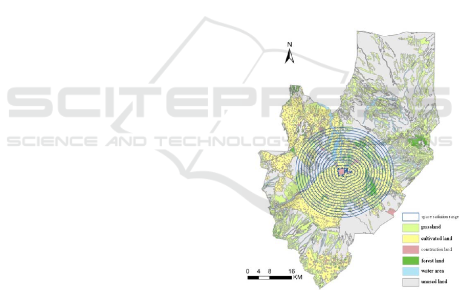
construction land. Figure 1 shows the land use in
1987.
Figure 1: Map of the Ganzhou District center land-use in
1987 and the division of the radiation ring layer.
3.2 Sample of Radiation Scale
The spatial extent of the radiation range is related to
the economic development level of the city. Some
relevant scholars use the market breakpoints to study
the economic radiation range in developed cities,
and conclude that the radiation range is from 30 to
200 km. For this research studies from the
IWEG 2018 - International Workshop on Environment and Geoscience
208

perspective of land use, and Ganzhou District is an
underdeveloped region, so the scope of the
expansion of construction land is determined to be
15 km. Taking the boundary of the central city of
Ganzhou District in 1987 as the starting boundary of
radiation and the interval of 1 km as the radiation
impact analysis scale, then used ArcGIS 9.3 to make
multi-ring buffer for all the 5 phases data, and
finally format the 15 spatial scales. Fig.1 shows the
division of the radiation ring layer.
3.3 Spatial Radiation Effect
Measurement Methods
3.3.1 Analysis of Land Use Dynamic Degree
Analysis on dynamic degree of land use: Using the
dynamic model, including single and comprehensive
land use dynamic degree, to analyze the land use
changing trend. The single land use dynamic degree
formula is as Eq.1.
%100
1
b
TU
UU
K
a
a
(1)
Where K means the dynamic degree of one type
of land use in the study area; U
a
,U
b
are determined
separately for the number of land use types in the
beginning and end of the study period; T means the
study period, if T represents year, then K value is the
annual rate of one land use type in study the region.
3.3.2 Land Use Transfer Matrix.
The land use transfer matrix is used to calculate
different types of area transfer rates(T
ij
), and then to
analyze the mutual transformation between land use
types in different radiation ranges. The transfer rate
T
ij
are calculated as follows:
15
ij ij ij
1
100
j
TA A
(2)
T
ij
refers to the proportion of land use/cover type
i in the k period is converted to land use/cover types
j in the k+1 period; A
ij
refers to the land use area.
With the continuous outward expansion of the
urbanized ring, the area of the radiation zone is
getting larger and larger. To make the analysis data
comparable, this paper uses relative area (a ratio of
land use/coverage type area to radiation circle area)
to analysis the radiation effect.
4 RESULTS ANALYSIS
4.1 Analysis of Land Use Dynamics
Figure 2 shows the dynamic degree of landscape
types varies with the radiation distance at different
times. The dynamic degrees of construction land in
different stages are all positive; indicating that the
construction land area is increasing continuously,
the time period of the maximum dynamic degree is
from 2006 to 2011, which is in the 3
rd
ring. The
minimal dynamic degree is from 1987 to 1995, all
the change rate are less than 5%. The dynamic
degrees of cultivated land are not all positive; the
negative values converted into positive values are in
the 4
th
and 5
th
ring in each study period, from 2006
to 2011, the change rate is the largest and in the 1
st
ring the cultivated land has the fastest reduction rate.
Grassland changes show two obvious changes stages.
First, the dynamic degree in the 5
th
ring reached the
positive maximum from 2006 to 2011, and the other
is that the dynamics of the 8
th
to 12
th
ring alternated
between positively and negatively. The change trend
of forest land is relatively simple, within the 2
nd
to
the 7
th
rings, which remains unchanged. Within the
8
th
to the 11
th
rings, there is a slight increase and
decrease in small fluctuations, the change in the 14
th
ring is more obvious. The dynamic degree of the
water area fluctuates greatly in the first six rings,
and from the 7
th
ring, the dynamics of each period
are negative. The dynamic degree of unused land is
basically negative, and the absolute value of
negative value increases with time, indicating that
the reduction of unused land is more distinctly.
4.2 Analysis of Time-Space Scale Effect
Figure 3 shows the distinctive features of each ring
in Ganzhou District. In terms of time, within the 5
th
ring, the proportion of cultivated land is the largest,
the advantages of other landscape types have
gradually decreased with the passage of time, and
the cultivated land area decreased the fastest and
greatest, but the proportion of construction land has
become ever larger. Beyond the 10
th
ring of the oasis,
the proportion of cultivated land increases year by
year, and the area of unused land continues to
decrease.
Study on the Radiation Effect of Urban Spatial Expansion in an Oasis - A Case Study of Ganzhou District in Zhangye City
209
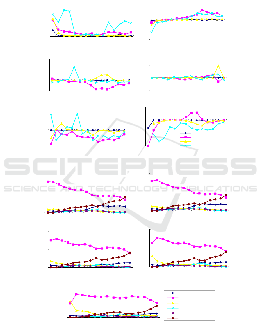
Figure 2: Dynamic degrees of different landscape types in different radiation ranges from 1987 to 2011.
Figure 3: Changes in landscape types with different radiation ranges from 1987 to 2011.
0
10
20
1 2 3 4 5 6 7 8 9 10 11 12 13 14 15
change rate
(%)
radiation range
(a)construction land
-10
-5
0
5
10
1 2 3 4 5 6 7 8 9 10 11 12 13 14 15
change rate
(%)
radiation range
(b)cultivated land
-14
6
26
123456789101112131415
change rate
(%)
radiation range
(c)grassland
-50
0
50
100
2 3 4 5 6 7 8 9 10 11 12 13 14 15
change rate
(%)
radiation range
(d)forest land
-14
-4
6
16
123456789101112131415
change rate
(%)
radiation range
(e)water area
-20
-10
0
10
123456789101112131415
change rate
(%)
radiation range
(f)unused land
1987 to 1995
1995 to 2000
2000 to 2006
2006 to 2011
0%
50%
100%
123456789101112131415
Relative area
percentage
radiation range
1987
0%
50%
100%
123456789101112131415
Relative area
percentage
radiation range
1995
0%
50%
100%
123456789101112131415
Relative area
percentage
radiation range
2000
0%
50%
100%
123456789101112131415
Relative area
percentage
radiation range
2006
0%
100%
1 2 3 4 5 6 7 8 9 10 11 12 13 14 15
Relative area
percentage
radiation range
2011
grassland
cultivated land
construction land
forest land
water area
unused land
IWEG 2018 - International Workshop on Environment and Geoscience
210
Spatially, we can see the dominate landscape in
different rings are different. Cultivated land is the
largest proportion of all landscape types, and it is
consistent with the main industry of agriculture in
Ganzhou District, which demonstrates that the
cultivated land is the substrate of the oasis. When
moving outward, the dominant position of cultivated
land is gradually weakened. The construction land is
mainly concentrated within the 5
th
ring, and beyond
this ring the advantage gradually decreases. Forest
lands and grasslands are concentrated mainly in the
oasis periphery or areas outside the 9
th
ring, and the
proportion of waters area in each ring is relatively
low. As the ring numbers increase outward, the ratio
of unused land area has gradually increased, and
undeveloped land begins dominate in the 15
th
ring.
Generally, as we progress from the inside ring to the
outside ring, the landscape characteristics present as
“construction land, cultivated land, and unused
land”.
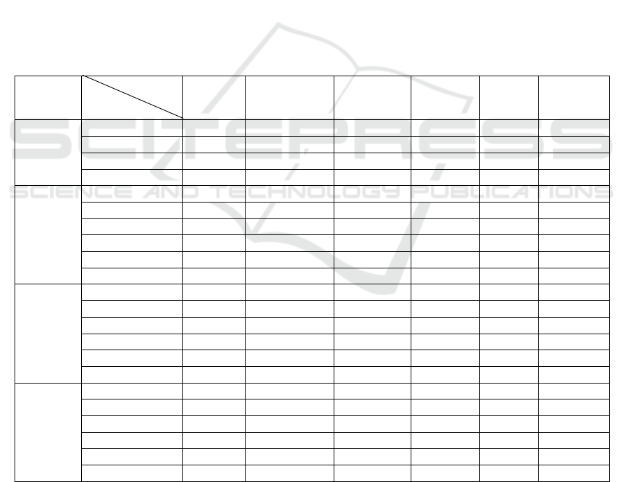
4.3 Land Use Transfer
In order to highlight the typicality and
representativeness, this paper chooses the 1
st
, 4
th
, 9
th
,
and 15
th
rings of land circulation to analysis the land
use transfer situation from 2006 to 2011.
The results in Table 1 implies that the conversion
ratio of construction land in each ring is 100%, and
the conversion of land in the 1
st
ring only occurs into
the grassland, farmland, water area and construction
land categories. The highest proportion which is
converted into construction land is grassland,
followed by cultivated land, and the proportion is 50%
and 34.6%, respectively.
Table 1: Land Use Conversion Matrix from 2006 to 2011 (Unit: %).
Radiation
rings
2006
2011 grassland cultivated land
construction
land
forest land
water
area
unused
land
1
st
ring
grassland 46.5 1.5 75.7
cultivated land 3.5 63.8 23.9
construction land 50.0 34.6 100 0.4
water area 0.1
4
th
ring
grassland 72.8
cultivated land 0.3 95.8 5.7 0.9
construction land 15.5 3.8 100 10.19 5.7 54.3
forest land 11.4 89.81
water area 0.4 88.4 13.3
unused land 0.2 31.5
9
th
ring
grassland 62.9 6.4 2.4
cultivated land 19.5 98.8 6.2 64.4 13.5
construction land 0.7 100 2.0
forest land 17.6 0.4 87.4 2.5 12.0
water area 0.1 28.7 2.6
unused land 4.4 67.5
15
th
ring
grassland 82.0 0.4 46.9 2.2
cultivated land 14.0 98.5 43.7 12.4 5.7
construction land 3.6 1.0 100 0.1
forest land 0.0 0.0 9.4 0.6
water area 0.0 0.0 82.5 0.5
unused land 0.4 0.1 5.1 90.9
Study on the Radiation Effect of Urban Spatial Expansion in an Oasis - A Case Study of Ganzhou District in Zhangye City
211

In the 4
th
ring, all types of land have been
converted into construction land, of which the
highest conversion ratio is unused land, followed by
grassland and forest land. In the 9
th
ring, the main
land converted into construction land wasunused
land and cultivated land, but the proportion was
small. In the 15
th
ring, in addition to self-
transformation, there is a small part of grassland,
cultivated land, and unused land converted into
construction land.
The proportion of grassland converted to
construction land in the 1
st
ring is much higher, and
the ratio of conversion to forest land is increased in
the 4
th
ring. In the 9
th
ring, the grassland is converted
to cultivate land and forest land. In the 15
th
ring,
grassland is mainly converted to cultivated land.
Cultivated land in the 1
st
ring is more intense, and
other rings are less transferred, indicating that the
protection of cultivated land is conducive to stabilize
the amount of cultivated land. The conversion of
forest lands in the 1
st
, 4
th
and 9
th
rings is relatively
small, but in the 15
th
ring, the conversion ratio to
farmland and grassland significantly increases. The
conversion of water area is closely related to
cultivated land. Unused land is mainly converted to
construction land in the 4th ring, and is converted to
cultivated land and forest land in the 9
th
ring.
Generally, with the passage of time, land use
conversion is more and more frequently, especially
the increase of the conversion intensity of unused
land, indicating that the utilization rate of unused
land is getting higher and higher. Although
cultivated land was occupied to a certain extent
during the study period, which occurs in the core
area of the town, and the conversion ratio of
cultivated land in other rings is not significant,
indicating that the cultivated land is well protected
during the expansion of the oasis towns in Ganzhou
District.
5 CONCLUSIONS AND
DISCUSSION
In the process of development, oasis cities and
towns are constrained by various factors, such as
water resources, desertification, land use patterns,
and land management levels. This paper mainly
analyzes the land use/cover change and radiation
effect of the oasis towns from the point view of land
landscape, which shows that the effect of the ring
structure of urban radiation becomes more and more
obvious with the passage of the time. The main
conclusions are:
(1) The dynamic changes of land use in oasis
towns show that in the time series, from 1987 to
1995, the change rates of all the land use types are
the lowest, while the highest change rate is in the
phase of 2006 and 2011. The change of land use
cover in different time periods is different in
different rings, and the change rate of construction
land in different radiation distances is greater than
zero, indicating that the area of construction land is
continuously increasing. The change rate of
cultivated land is negative within the 5
th
ring, and
positive from the 5
th
ring, showing that the closer the
distance from the core area is, the faster the
cultivated land area decreases.
(2) By calculating the relative area ratio of each
ring, three different radiation ring layers can be
concluded: 1 to 5 km is the radiation core zone of
the town; 6 to 10 km is the radiation transition zone
of the town, while 11 to 15 km is the periphery zone
of the town. As the radiation area continues to
expand, the area ratio of construction land gradually
decreases. In the core zone, the increase of
construction land and the decrease of cultivated land
maintain the opposite trend, indicating that the
expansion mode of the urban core area of Ganzhou
Oasis has taken up amount of cultivated land.
(3) The land use conversion is more intense in
the core ring layer, and not obvious in the outer ring
layer. The main conversion sources of the
construction land are from the core zone, which are
cultivated land and grassland. Land use conversion
is characterized by the disappearance of unused land
in the 1
st
ring, which translates into construction
land, and from other side, it greatly improves land
use efficiency. In the outer ring, the proportion of
other types of land converts into cultivated land
increases, and urban expands to the periphery. The
grassland conversion mainly takes place in the 1
st
and 4
th
rings, and is mainly converted into cultivated
land and construction land; the cultivated land
conversion mainly takes place in the 1
st
ring, which
is mainly transformed into construction land; the
transformation rate of forest land, water areas and
unused land in each ring has increased, but not
obvious.
The spatial radiation effect of urban expansion is
due to the increase of land use in cities and towns,
resulting in a corresponding spatial pattern of
changes in other types of land use. Urban expansion
is influenced by many factors such as natural
IWEG 2018 - International Workshop on Environment and Geoscience
212

geography, government decision-making, urban
planning, economic factors, and transportation,
compared with other regions, the oasis region is
constrained by water and land resources, and the
urbanization process has a greater impact on the
transformation of land use types in the surrounding
areas. On the spatial scale, the core area of oasis
towns has obvious influence on the land use change
in adjacent areas, among which the changes of
cultivated land, grassland, construction land and
unused land all have certain regularities. Far from
the central city and town, cultivated land and
grassland decrease first and increase later.
Construction land gradually decreased with the
distance far from the town centre, while the unused
land was in the opposite. The results of the study
may be affected by the distance of the radiation
circles, different scales will lead to different
conclusions. Future research will focus on the
selection of the radiation circle and scale study, and
how the different scales effect on land use change.
ACKNOWLEDGEMENTS
This work is funded by National Natural Science
Foundation of China (Grant No. 41661035) and
Young Teachers Scientific Research Ability
Promotion Plan of Northwest Normal University
(Grant No. NWNU-LKQN-14-14).
REFERENCES
Alimujiang K S M,Tang B,Gulikezi T L K 2013 Analysis
of the spatial-temporal dynamic changes of urban
expansion in oasis of Xinjiang based on RS and GIS
Journal of Glaciology and Geocryology 35(4) 1056-
1064
Fang C L, Bao C, Huang J C 2007 Management
implications towater resources constraint force on
socio-economic system in rapid urbanization:A case
study of the Hexi Corridor,NW China Water
Resources Management 21 1613-1633
Li X L,Xiu C L,Alexander Shendrik,et al. 2017
Characteristics and Mechanism of Land Use Pattern of
St.Petersburg Scientia Geographica Sinica 37(9)
1382-1391
Liang Y J,Xu Z M,Zhong F L 2011 Land use scenario
analyses by based on system dynamic model and
CLUE-S model at regional scale: A case study of
Ganzhou district of Zhangye city Geographical
Research 30(3) 564-576
Liu H L,Shi P J,Tong H L,et al. 2015 Characteristics and
Driving Forces of Spatial Expansion of Oasis Cities
and Towns in Hexi Corridor, Gansu Province, China
Chinese Geographical Science 25(2) 250-262
Ma G X,Gan G H,Tian Y J 2006 Development Models of
Zhangye Oasis Cities and Towns under Restraint of
Water Resources Journal of Desert Research 26(3)
426-431
Ma X K,Gao M H 2017 Dynamic assessment of land
ecologic safety of oasis city in arid northwest China:a
case of Korla City in Xinjiang Arid Land Geography
40(1) 172-180
Pei F F,Li X,Liu X P,et al. 2015 Exploring the response of
net primary productivity variations to urban expansion
and climate change:A scenario analysis for
Guangdong Province in China Journal of
Environmental Management 150 92-102
Qiang H Y,Zhang X L, Lei J 2010 Oasis urban system in
arid area of Xinjiang based on fractal theory Arid
Land Geography 33(5) 802-808
Qiao W F,Sheng Y H,Fang B,et al. 2013 Land use change
information mining in highly urbanized area based on
transfer matrix: A case study of Suzhou, Jiangsu
Province. Geographical Research 08 1497-1507
Wang H J,Xia C,Zhang A Q,et al. 2016 Space syntax
expand intensity index and its applications to
quantitative analysis of urban expansion Acta
Geographica Sinica 71(8) 1302-1314
Wu W J, Shi P J, Hu W 2012 Study on land ecological
risk in oasis city based on LUCC:a case study in the
Ganzhou district Arid Zone Research 29(1)
122-128
Xu X L,Tong L G,Zheng K D 2012 Spatial-temporal
characteristics and scenario prediction of urban
expansion in Beijing-Tianjin-Hebei Metropolitan
Region China Population,Resources and Environment
22(11) 256-261
Yu H R,Pu C L,Li Y,et al. 2013 Multi-objective land-use
optimization of oasis city:a case study in
Kuytun,Xinjiang Journal of Desert Research 33(4)
1267-1272
Zhang X L,Zhang N,Sun X Y,et al 2010 Spatial effects of
urban expansion in the oasis of arid region Journal of
Natural Resources 25(2) 227-235
Study on the Radiation Effect of Urban Spatial Expansion in an Oasis - A Case Study of Ganzhou District in Zhangye City
213
