
Spatiotemporal Data-Cube Retrieval and Processing with xWCPS
George Kakaletris
1
, Panagiota Koltsida
2
, Manos Kouvarakis
1
and Konstantinos Apostolopoulos
1
1
Communications & Information Technologies Experts S. A. Athens, Greece
2
Department of Informatics & Telecommunications, University of Athens, Athens, Greece
Keywords: Query Language, Array Databases, Coverages, Metadata.
Abstract: Management and processing of big data is inherently interweaved with the exploitation of their metadata, also
"big" on their own, not only due to the increased number of datasets that get generated with continuously
increased rates, but also due to the need for deeper and wider description of those data, which yields metadata
of higher complexity and volume. Taking into account that generally data cannot be processed unless enough
description is provided on their structure, origin, etc, accessing those metadata becomes crucial not only for
locating the appropriate data but also for consuming them. The instruments to access those metadata shall be
tolerant to their heterogeneity and loose structure. In this direction, xWCPS (XPath-enabled WCPS) is a novel
query language that targets the spatiotemporal data cubes domain and tries to bring together metadata and
multidimensional data processing under a single syntax paradigm limiting the need of using different tools to
achieve this. It builds on the domain-established WCPS protocol and the widely adopted XPath language and
yields new facilities to spatiotemporal datacubes analytics. Currently in its 2nd release, xWCPS, represents a
major revision over its predecessor aiming to deliver improved, clearer, syntax and to ease implementation
by its adopters.
1 INTRODUCTION
Petabytes of data of scientific interest are becoming
available as a result of humanity's increased interest
and capability to monitor natural processes but also to
model them and explore the results of those
theoretical models under different conditions. This
trend on its own puts data infrastructures storage and
transfer mechanisms under severe pressure, not to
mention the processing ones. Duplicating or moving
those data at their final consumption point is usually
beyond its capabilities, as network and local storage
capabilities cannot catch up this trend. It is a direct
consequence of this observation that it is important to
develop mechanisms to support efficient data
identification, filtering and in-situ processing that will
reduce the need for unnecessary data move and
duplication.
On the other hand, it is also evident that in order
to pick the appropriate data and subsequent to
consume them, one needs to be able to identify those
data among a huge number of data sets. This sums to
the point that more complex and more detailed
metadata that cover an increasing number of aspects
of the data they describe are required and produced.
As the volume of produced data grows larger, so
does the volume of metadata that offer information
about them, and it is evident that their handling need
efficient retrieval mechanisms too, however those can
no longer be considered independently of the
mechanisms that handle the data, as both are needed
together. A data science field where those
observations apply to their full extent, and the area
where the work presented herein focuses on, is the
geospatial one. Data from the domain are
multidimensional, diverse in terms of content and size
and are accompanied with metadata that are essential
for their retrieval and processing.
Regarding data management, traditional database
management systems (DBMSs) do not efficiently
support array data, which is the most common form
of data met here. This led to the development of
dedicated array DBMSs like SciDB (Brown, 2010)
and Rasdaman (Baumann, 1998), which close this
gap by extending the supported data structures with
multidimensional arrays of unlimited size, thus
enabling the efficient storage of spatiotemporal data.
Although array databases manage to handle these
types of data they lack dealing with metadata filtering
and processing in a unified way.
148
Kakaletris, G., Koltsida, P., Kouvarakis, M. and Apostolopoulos, K.
Spatiotemporal Data-Cube Retrieval and Processing with xWCPS.
DOI: 10.5220/0006814601480156
In Proceedings of the 4th International Conference on Geographical Information Systems Theory, Applications and Management (GISTAM 2018), pages 148-156
ISBN: 978-989-758-294-3
Copyright
c
2019 by SCITEPRESS – Science and Technology Publications, Lda. All rights reserved

Our approach, manages to deliver efficient cross
disciplinary querying and processing of array data
and metadata, by offering a unified and friendly way
through the xWCPS 2.0. xWCPS 2.0 is built on the
first specification of the language xWCPS 1.0
(Liakos, 2014), as defined in EarthServer Project
(EarthServer.eu, 2018) and refines its characteristics,
so it facilitates implementation, improves expected
query performance and eases user adoption and
usage. In contrast to traditional approaches, where
two different queries are required so as to first filter
the semi structured metadata, retrieve and process the
results, in our approach the same functionality can be
achieved by executing just one unified query,
resulting the least number of data transferred to their
final consumption point. To overcome those
limitations, we propose a query language with clear
and user friendly syntax and we offer a working
engine for it, in which its core components are a new
metadata management engine, called FeMME, that
follows a scalable no-SQL approach fitting the needs
of the endeavour, and a proven array database system,
Rasdaman and we efficiently combine them to
support unified processing and retrieval of array data
and metadata.
2 CONCEPTS AND MOTIVATION
The fundamental ideas behind this work have
emerged from the EarthServer project series, which
set as an objective to establish Agile Analytics on
Petabyte Data Cubes as a simple, user-friendly and
scalable paradigm. The mandate of the project
includes the delivery of a standards’ based,
declarative query language that enhances geospatial
data infrastructures by allowing combined
multidimensional data and metadata filtering and
processing. xWCPS, in its current 2
nd
version, is built
on top of xWCPS 1.0 and combines two widely
known specifications, XPath (W3c.org, 2018) and the
Web Coverage Processing Service (WCPS) standard
(Baumann, 2010) into a single FLWOR (acronym
For-Let-Order By-Where-Return, which stands for
For-Let-Where-Order-Return) syntax to achieve the
aforementioned result.
In the root of the overall approach lies the concept
of “coverage” (OGC, 2017), a fundamental element
in Open Geospatial Consortium (http://www.open
geospatial.org/) ecosystem. The coverage refers to
data and metadata representing multidimensional
space/time-varying phenomena. The OGC has
introduced a number of standards and specifications
for accessing, retrieving and processing coverages,
the Web Coverage Service (WCS) (Baumann, 2012)
being one standard to support the access of raster data
that are handled as coverages. WCS defines requests
against these data and returns data with original
semantics (instead of raster images). WCS supports
the delivery of rich metadata about coverages,
however it yields huge flexibility on those metadata
to their provider making assumptions on the nature
and form of those metadata, irrelevant.
Complementing WCS, the Web Coverage Processing
Service offers processing capabilities on top of array
data using its defined language, allowing ad-hoc
processing of coverage data. Examples include
deriving composite indices (e.g. vegetation index),
determining statistical evaluations, and generating
different kinds of plots like data classifications,
histograms, etc.
The primary structure of the WCPS language
comprises the for-where-return clauses. The “for”
clause specifies the set of coverages that will be
examined by a query. The “return” clause specifies
the potential output that may be appended to the list
of results, in each iteration defined by the “for”
clause. Criteria used for determining if the output of
“return” is actually appended are specified by the
“where” clause.
It has to be noted that WCS and WCPS are
implemented by Rasdaman array database, which is
OGC's official Reference Implementation for WCS
Core. Rasdaman (Baumann, 1998), raster data
manager, is a fully parallel array engine that allows
storing and querying massive multi-dimensional
arrays, such as sensor data, satellite imagery, and
simulation data appearing in domains like earth,
space, and life sciences. This array analytics engine
distinguishes itself by its flexibility, performance, and
scalability. From simple geo imagery services up to
complex analytics, Rasdaman provides the whole
spectrum of functionality on spatio-temporal raster
data - both regular and irregular grids.
Although in EarthServer project they are faced
from the geospatial domain standpoint and expressed
as coverages, multi-dimensional arrays are far from
domain specific data form, and play a central role in
all science, engineering, and beyond. Consequently, a
significant number of approaches for retrieval from
arrays have been proposed for different purpose
applications. In practice, though, arrays typically are
forming part of some larger data structure. Array SQL
is a horizontal technology that – by its key enabling
features flexibility, scalability, and information
integration – enhances all fields of data management.
In this domain it is evident that data cannot be
consumed without metadata describing their essence.
Spatiotemporal Data-Cube Retrieval and Processing with xWCPS
149

Various and important characteristics reside into their
metadata, thus making the consideration of joint
filtering and processing of data and metadata a
fundamental requirement. However, metadata
engagement in this context has been largely ignored
until recently, and this is the gap that our approach
comes to fill in.
In prior approach, in order to accommodate this
requirement, xWCPS 1.0 (Liakos et Al, 2014) has
been specified and implemented by merging the
WCPS standard with the XQuery language, thus
eliminating the limitations of the WCPS and WCS
queries and allowing the parallel and combined query
and processing for both data and metadata. Although
xWCPS 1.0 and its initial implementation met the
requirements mentioned above and managed to fill
the gap of jointly accessing and processing data and
metadata, it was evident that would not easily cope
with challenges of the near future, where billions of
datasets may be present in a federated infrastructure
of even in single data server. The main problems of
this approach can be summarized below: a) its syntax
proved to be cumbersome for the users, especially
dealing with the XQuery syntax and b) its engine
implementation relied on XML management systems,
with full XQuery support, that could not perform as
required for extremely large metadata volumes and
complexity. These limitations became evident during
the adoption tests of xWCPS 1.0 that took place in the
EarthServer-1 project.
To overcome all these issues xWCPS 2.0 has been
designed and implemented in EarthServer-2 project
and is presented in detail in the following sections.
3 xWCPS 2.0
The management of big multidimensional datasets,
e.g. coverages, poses a number of issues and
challenges due to their size, nature and the diversity
in phenomena and processes they might represent.
Combining this with the velocity those are generated,
be it generation of data from sensing, simulations and
transformations, the demand for efficiently
identifying, filtering and processing them (and if
possible in a distributed manner) has emerged. At a
certain point where users need to refer to large data
stores, it becomes clear that the simultaneous
utilization of metadata and array data is required so
that the precise piece of data needed is located and
processed according to its form and characteristics
and the requirements of its consumer/client.
To accommodate this in our approach, two well-
known standards, XPath for metadata
filtering/extracting and the Web Coverage Processing
Service (WCPS) for array data processing, are
combined, allowing an operation to be executed
utilizing both of them without roundtrips or explicit
knowledge of the characteristics of the data and the
system they reside on, that is the case until now at
least in the geospatial domain. The result is a
declarative query language that follows the For-Let-
Where-Order-Return paradigm (expressed as
FLWOR) that offers a clear, well defined syntax,
improving the way scientific data can be accessed and
eliminating the need of prior knowledge of the data
identifiers and characteristics. A similar approach
was followed in the xWCPS 1.0, however use of full
XQuery was assumed leading to the no user
acceptance due to its bewildering syntax. The 2
nd
release drops XQuery in favour of XPath, with some
additional elements yielding several positive results
both from implementation and utilization standpoints.
In the rest of this section we provide a brief
introduction to the fundamentals of xWCPS 2.0
describing the core idea, its syntax, a number of use
cases, and summarizing important notions for this
paper. In the rest of the paper, for simplicity, we refer
to xWCPS 2.0 with the term xWCPS.
3.1 Approach
One of the fundamental operations a query language
must offer is that of querying for all data residing in
the database without prior knowledge of their internal
representation. WCPS requires the specification of
coverage identifiers in selection queries. These
identifiers are part of the database’s resource
description and can be retrieved by issuing a WCS
operation. This step introduces overhead in the
querying process, which significantly constrains the
user-friendliness of the query language and
undermines the overall user experience. Another very
common feature a query language must offer is that
of filtering results according to some specified
criteria. However, when a user asks for array data
with WCPS in order to select coverages, it is not
possible to define conditions regarding the
accompanying metadata. Finally, yet importantly, it
is fundamental for a language to return all the
available information, containing both data and
metadata.
xWCPS (XPath Enabled WCPS) is a Query
Language (QL) introduced to fill these gaps, merging
two widely adopted standards, namely XPath 2.0
because of its capabilities on XML handling and
WCPS's raster data processing abilities, into a new
construct, which enables simultaneous exploitation of
GISTAM 2018 - 4th International Conference on Geographical Information Systems Theory, Applications and Management
150
both coverage metadata and payload in data
processing queries. By combining those two, it is
delivering a rich set of features that revolutionizes the
way scientific data can be located and processed, by
enabling combined search, filtering and processing on
both metadata and OGC coverages' payload. In brief,
queries expressed in xWCPS are able to utilize
coverage metadata - commonly expressed in XML -
by incorporating support for FLWOR expression
paradigm and providing the appropriate placeholders
that enable any XPath or WCPS or combined query
to be expressed in its syntax.
Expressiveness and coherence are key features of
the language, now in its 2nd revision, allowing
experts dealing with multidimensional array data to
easily adopt and take advantage of its offerings. In
general, xWCPS is designed to consist the following
features:
• Coverage Identification based on Metadata:
WCPS requires the specification of coverage
identifiers in selection queries. xWCPS is
introduced to fill this gap and eliminate the need
of prior knowledge of the data by offering a
unified interface aiming at being rich,
expressive and user friendly and allowing
coverage selection based on an XPath
expression.
• Exploitation of Descriptive Metadata:
Coverage filtering based on the available
metadata using XPath 2.0. For and where
clauses can contain XPath 2.0 expressions in
order to restrict results to specific metadata.
• Repetitiveness Reduction: xWCPS supports
variable manipulation, which allows assigning
complex expressions to variables and re-using
them for subsequent references, avoiding
repetitiveness.
•
Extended Set of Results Support: An
important feature of xWCPS is the ability to
return the data accompanied with their
metadata.
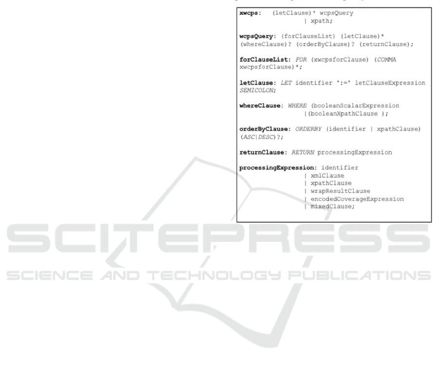
3.2 Syntax
Queries are the most fundamental part of the
language. A simple WCPS query is based on a "for-
where-return" structure. An xWCPS query is
composed from several expressions, including the
basic three clauses "for-where-return" of WCPS,
while introducing the "let-order by" structure and
XPath 2.0. Additionally, xWCPS includes special
operators to provide easier search abilities to filter
specific metadata. The top-level grammar of xWCPS
is presented on Figure 1. xWCPS acts as a wrapper
construct on top of XPath 2.0 and WCPS, thus it
doesn't offer any language specific operations. Every
valid WCPS or XPath 2.0 operation is a valid xWCPS
operation; xWCPS combines WCPS with XPath 2.0
operations using a rather simple syntactic formalism.
Figure 1: xWCPS Syntax.
3.2.1 For Statement
The "for" statement snippet is: {
for
variable_name in for_expression}.
It can also contain the let clause allowing variable
definition that can be used later on. The for clause
binds a variable to each item returned by the in
expression. There are 3 options that can be used in a
‘for’ statement:
• Use all available coverages: *
• Use all coverages of a specific service:
*@endpoint (endpoint can be a url with double
quotes or an alias)
• Use specific coverages: coverageId or
coverageId@endpoint (endpoint can be a url
with double quotes or an alias)
3.2.2 Let Statement
The let statement snippet is:
{let variable_name := wcps_clause;}
The let clause can initialize variables following an
assignment expression that finishes with a semicolon.
The use of the let clause can greatly reduce
Spatiotemporal Data-Cube Retrieval and Processing with xWCPS
151

repetitiveness, making xWCPS extremely less
verbose than WCPS. Moreover, arithmetic operations
can be executed between defined variables.
3.2.3 Where Statement
The where statement is used to specify one or more
metadata or coverage related criteria for filtering
down the returned result. Currently combined data
and metadata join operations are not allowed in the
context of xWCPS. Every XPath or WCPS
expression evaluating to a boolean result is a valid
xWCPS comparison expression. To declare an xPath
expression the “::” notation should follow the
variable. That notation fetches the metadata of the
coverage where the xPath is evaluated.
3.2.4 Order by Statement
The Order by statement has the following syntax:
{order_by_expression (asc | desc)}
Results can be sorted using ORDER BY. Like in
FLWOR expressions, the construct takes one or more
order expressions that each can have an optional order
modifier (ASC or DESC).
The order by clause is used to rank the returned
coverages based on an XPath clause applicable on
their metadata. If direction is not defined explicitly,
ascending is used by default.
3.2.5 Return Statement
The return statement of a query specifies what is to be
returned and the way that this result should be
represented. It can contain textual results, structured
XML results, WCPS encoded (i.e. png, tiff, csv)
results or combinations of binary and textual data as
mixed results. xWCPS acts as a wrapper construct on
top of XPath 2.0 and WCPS, thus it doesn't offer any
language specific operations. Thus we can have the
following options:
• Use the encode function of WCPS -> WCPS
result
• Use "::" operator -> Fetch metadata -> XML
result
• Use an xPath 2.0 expression / function -> XML
result
• Use the new “mixed” function to combine both ->
Multipart result
3.3 Use Cases
The features and functionality introduced with
xWCPS are presented in this section through a
number of use cases, examples. The queries represent
the expressive power of our language and its
superiority over WCPS in array database search. In
the context of the EarthServer project we have tested
the effectiveness of xWCPS by searching over array
databases with terabyte of data and metadata by
registering the services and their metadata into the
catalogue. Six services are part of the EarthServer
project and all of them are making available terabytes
of data. More information is available in the public
reports of the project.
3.3.1 Retrieving Data and Metadata using
Special Characters
XQuery was a key feature of xWCPS 1.0. Now in its
2nd revision, xWCPS is based on XPath in order to
accomplish user friendliness and simplified queries to
retrieve data and metadata. Special characters are
introduced for expressiveness in order to easily
retrieve all coverages and/or filter them by endpoints.
The example below shows a query that uses both *
and @ special characters to fetch all coverages from
a specific service endpoint and return part of the
actual coverage as a result. The encode function of
WCPS defines the returned result in this specific case.
{for $c in *@ECMWF
return encode($c[ansi("2001-07-
31T23:59:00")] * 1000 , "png")}
while the following one shows a query that
fetches the metadata of a specific coverage using ::
special character.
{for $c in precipitation@ECMWF
return $c::}
3.3.2 Building Coverage Filtering Queries
using XPath
Filtering metadata of a coverage through XPath can
be applied in both where and return clause. In where
clause to decrease the number of results and in return
clause to manipulate what is presented as a result. The
following example has is accommodating both filter
options by filtering an XML attribute for a specific
value and then setting that attribute as the result. In
this example, the result contains only XML metadata.
{for $c in *@ECMWF
where $c:://RectifiedGrid[@dimension=2]
return $c:://RectifiedGrid}
GISTAM 2018 - 4th International Conference on Geographical Information Systems Theory, Applications and Management
152
3.3.3 Building Coverage Ordering Queries
using XPath and Let Clause
xWCPS supports the 'let' clause, which allows
assigning complex expressions to variables and re-
using them for subsequent references, avoiding
repetitiveness. In the following example a variable
called '$orderByClause' is assigned with the id of
every coverage that matches the 'for' clause. This
variable is firstly used to order the results and then to
be presented to the user as the returned value. Let
clause holds the result of a metadata expression
filtered by XPath.
{for $c in *@ECMWF
let $orderByClause :=
$c:://wcs:CoverageId/text();
orderby $orderByClause desc
return $orderByClause}
3.3.4 Retrieving a Mixed Form Containing
Data and Respective Metadata
An important feature of xWCPS is the ability to return
the data accompanied with their metadata reducing
the amount of queries required before and allowing
the user to retrieve only one result containing both.
This can be achieved using the 'mixed' clause of
xWCPS as can be seen in the example below:
{for $c in CCI_V2_monthly_chlor_a
return mixed(encode ($c[ansi("2001-07-
31T23:59:00")] * 1000 , "png"), $c::)}
In the query above, the usage of the mixed clause
will return a result that contains the actual coverage
processed as the encode function defines together
with the full set of metadata that accompanies it.
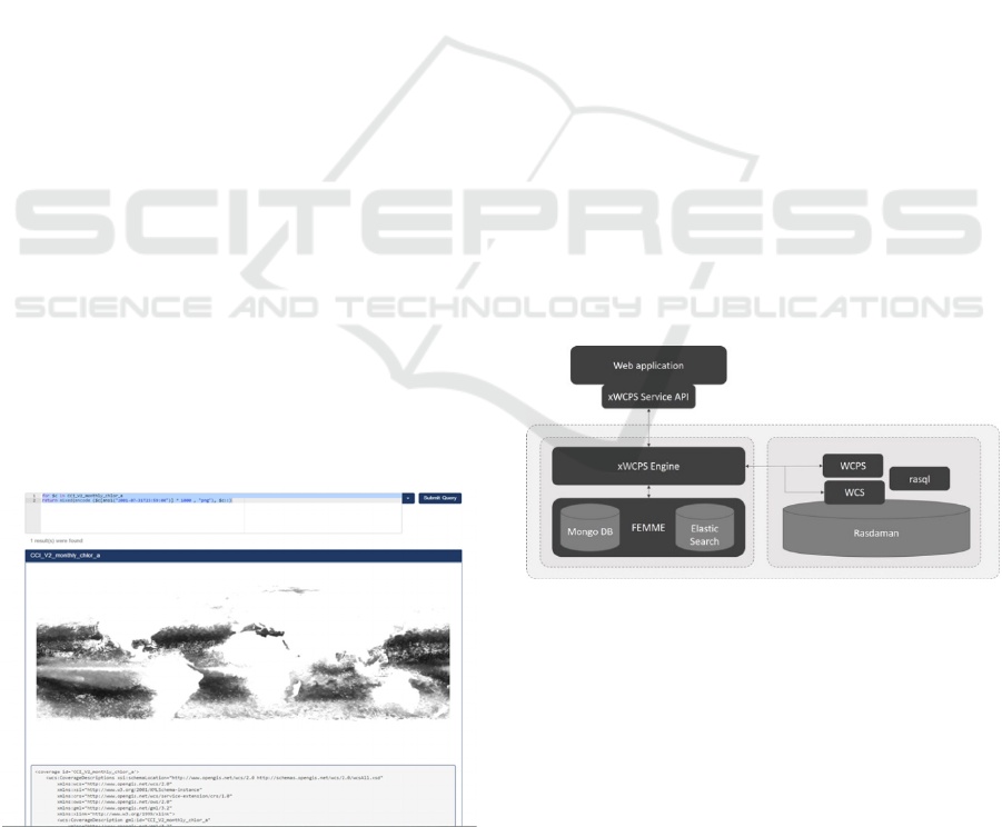
Figure 2: xWCPS Web Application.
The source result of an xWCPS query is in JSON
format and it contains both the metadata and the
actual coverage in base64 format. For simplicity the
xWCPS web application supports the execution of
xWCPS queries, including all the above examples.
Figure 2 shows how a mixed result is displayed in the
web application.
4 IMPLEMENTATION
4.1 Base Architecture
xWCPS constitutes of two distinct implementations.
Initially, a query parser has been implemented to
support the query translation based on the language
definition presented before. It uses the ANTLR 4
framework (ANTLR, 2018) and it translates the
xWCPS queries to source code. The language is
specified using a context-free grammar, which is
expressed using Extended BackusNaur Form
(EBNF). Open source grammars for WCPS and
XPath are extracted from (ANTLR WCPS, 2018) and
(ANTLR XPath, 2018) respectively.
The xWCPS engine implementation exploits
FeMME metadata management engine for the
metadata query support and it utilizes registered
Rasdaman servers for processing the (geospatial)
array queries following the WCPS syntax.
The overall architecture of the system is shown in
Figure 3.
Figure 3: xWCPS Engine Architecture.
xWCPS offers either a web application for end
users or a REST API for machine to machine
interaction. Any valid xWCPS query can be executed
and the results are returned to the consumer. The flow
for executing a query is the following: Initially the for
and where clauses of the query are analysed,
producing a composite query which is evaluated
against FeMME. Following the composite query
strategy, XPath evaluation on FeMME can be
optimized by restricting the number of coverages that
are considered for the XPath execution.
Spatiotemporal Data-Cube Retrieval and Processing with xWCPS
153

As soon as the first evaluation step is completed
the return statement is executed using the items
returned in the first step. Depending on its contents,
return can utilize either FeMME or Rasdaman.
Encode function is evaluated in its entirety using
Rasdaman and its supported geospatial operations.
Other available expressions, like XPath and metadata
retrieval, use FeMME to generate the returned result.
4.2 FeMME: Metadata Management
Engine
Metadata play a significant role in the evaluation of
an xWCPS query. It is the means of identifying and
filtering the available coverages through the executed
queries. The goal of the metadata management engine
is to amalgamate all this information into one
catalogue offering federated metadata search upon
coverages' descriptive information. In order to
support the execution of the metadata part of the
queries such an engine, termed “FeMME”, Federated
Metadata Management Engine, has been designed
and implemented. The main principles it adheres to,
are the metadata schema agnosticism, in order to
support storage, querying and manipulation of
descriptive metadata from various data sources and
querying (XPath) performance efficiency.
FeMME has been designed aiming on being
pluggable and supporting the storage of metadata
available through different protocols and standards.
To this end, a number of sub-components enable the
harvesting of metadata for every available collection
of coverages, which are first initialized with the WCS
available metadata and can then be enriched from
other catalogues supporting them.
xWCPS uses FeMME as its central point for
identifying and retrieving the required information
for each collection of coverages and for gaining
access to the Describe Coverage metadata and
executing the XPath queries.
4.2.1 XPath Performance Efficiency
In order to overcome the inherent memory and speed
limitations of in memory XPath, as proved to be the
main limitation of the initial implementation, it was
decided to utilize the speed and flexibility of NoSQL
systems to implement XPath.
The technology used initially was MongoDB. The
approach followed at first was to flatten an XML
document and store each XML element as a separate
document in MongoDB. Building a custom parser
allowed us to transform an XPath to a MongoDB
query and evaluate it in the database. An unforeseen
issue was that this method of “indexing” an XML
document resulted in the creation of a large number
of documents. For example, for a typical response the
number of documents produced was over 1000. As
the number of indexed metadata increased, so did the
overhead.
As a result, a different approach was followed.
Each XML document is transformed to one JSON
object, reflecting the XML document’s structure and
hierarchy. Each XML element would map to a JSON
node and children elements to children nodes.
Namespaces and attributes would be transformed to
children nodes. This way it is possible to transform
XML to JSON and vice versa without losing any
information.
In order to achieve better performance different
technologies were evaluated. ElasticSearch was
chosen to provide the storing and querying
capabilities. ElasticSearch also stores data as JSON
documents but, in contrast to MongoDB, indexes
every field of a JSON document. This fact promised
much better performance for queries that could query
for a value at any level of the document.
4.3 Federated Geospatial Queries
Execution
The execution of the geospatial, array queries of
xWCPS are executed remotely, by interacting with
the appropriate array database engine (i.e. rasdaman)
using a WCPS query. FeMME holds all the required
information for each registered array database
addressed by xWCPS in order to identify the
appropriate service endpoint that holds the coverages
defined, or is specified in the xWCPS query.
The system can interact with more than one data
management service at one query, allowing the
concurrent retrieval of data that are not part of the
same engine. This feature is considered to vastly
simplify the implementation of applications for array
data aggregation and presentation from multiple
sources through a unified way, rendering end-user
application development quite straight forward.
The performance of this part of the execution is
highly relying on the interconnection and
performance of the array database engines that
comprised the implied federation. It has to be noted
that the volume of the data transported may become a
reason for bottlenecks and delays.
GISTAM 2018 - 4th International Conference on Geographical Information Systems Theory, Applications and Management
154
5 APPLICATIONS
One of the main applications is applying the solution
over the Meteorological Archival and Retrieval
System (MARS). MARS is the main repository of
meteorological data at the European Centre for
Medium-Range Weather Forecasts (ECMWF).
MARS hosts operational and research data, as well as
data from special projects. The archive holds
Petabytes of data, mainly using GRIB format for
Meteorological fields and BUFR format for
Meteorological Observations. Most of the data
produced at ECMWF daily is archived in MARS, and
therefore available to users via its services.
The MARS archive integration aims to bring the
more than 100PB MARS archive of ECMWF to its
audience via the WCS and WCPS standards. Due to
its enormous size it is practically infeasible to ingest
the data into a system capable of exposing those via
the aforementioned standards, as this would require
twice the storage space. Thus, a different approach
had to be designed to allow only the required subset
of data that are addressed by a WCS/WCPS operation
to moved out of the archive when required.
xWCPS was chosen as the best candidate to
address these requirements due to its simplicity,
expressiveness and filtering capabilities. As the
project lays its array processing capabilities on the
Rasdaman engine, the objective is to move as little
data as feasible into the Rasdaman data store, on
demand and offload the remaining processing to the
Rasdaman engine. Utilizing the metadata
management capabilities of FeMME allowed the on
the fly data retrieval from MARS and subsequent
ingestion in Rasdaman. As soon as the MARS data lie
in Rasdaman, the aforementioned workflow of an
xWCPS query can be carried out.
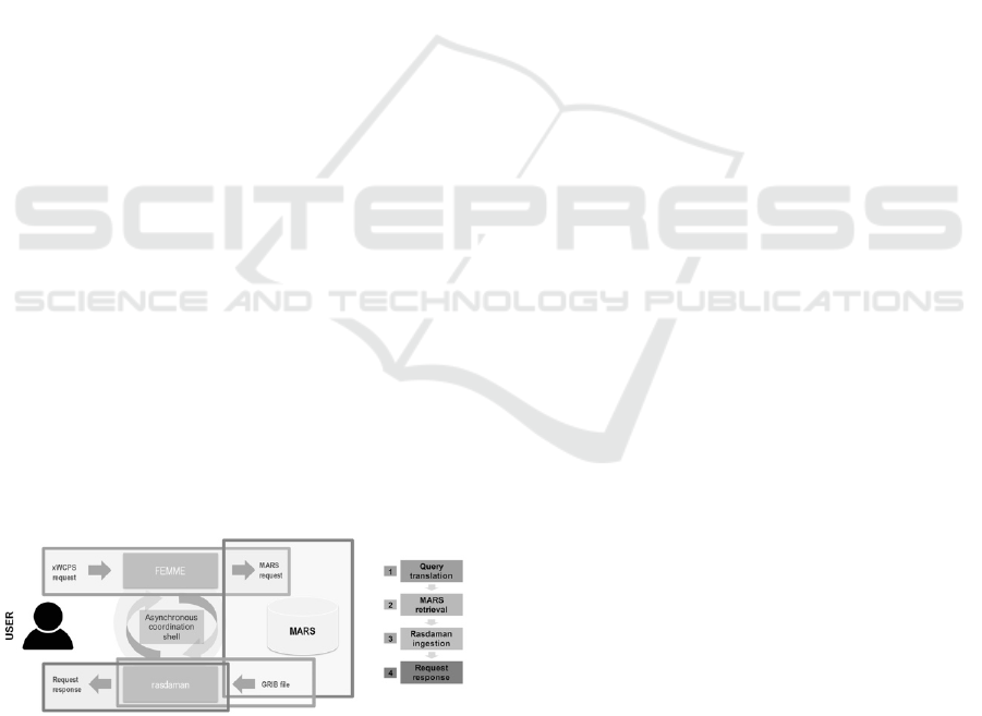
A descriptive diagram of how the MARS system
works, is shown in Figure 4.
Figure 4: MARS System Integration.
FeMME and xWCPS subsystems are surrounded by
a web UI that allows the exploration of coverages
under a familiar virtual globe, offered by NASA Web
World Wind 3D virtual globe technology [NASA
WWW] that allows rendering the coverage data and
metadata (bounding boxes). The combined platform
allows handling, retrieval processing and
visualization of various Coordinate Reference
Systems, making it possible to utilize the same stack
for rendering Earth as well as other solar body data.
6 EVALUATION
We evaluate our approach from two perspectives, (a)
the language definition and (b) its prototypical
implementation.
Regarding the language definition, as opposed to
xWCPS v1.0, we have an apparently simpler
grammar, giving away quite a significant part of
XQuery processing features, which is the main
drawback of the initial approach. However, this move
in, in par with the OGC-Extended Coverage
Implementation Schema which also suggests XPath
for querying hierarchical metadata. It has to be noted
that hierarchical metadata are assumed to be the
prominent model, be they in json or xml form,
although not the only or most powerful model in
place. Naturally due to the specification size,
potential clashes among WCPS and XPath are quite
fewer and as such are resolved in a more intuitive
manner, while the syntactic sugar added supports
common use cases identified within the hosting
project course and based on the feedback provided by
the rest of the partners, experts in the geospatial
domain.
xWCPS eases significantly implementation of
applications, as it removes the need for multistep
approach followed by coverage data consumers,
which encloses at least the steps of locating the
dataset, extracting the significant metadata for
processing it and finally processing its content. This
approach not only implies round trips but also
requires that the client understands the form of the
data/metadata infrastructure and reduces the
opportunity of server-side optimisation of data
management and processing.
Regarding the aspect of prototyping, the current
implementation is based on Rasdaman array database
for WCPS queries, on one hand and FeMMe engine
on the other for metadata retrieval and the two parts
of execution are orchestrated by the prototype's
execution engine. This has the drawback that little
optimisation can be performed at query time as
internal engine structures and processes run
separately. Nevertheless, the built-in heuristics (e.g.
assume that XPath execution is always faster than
accessing the array data) manage to avoid common
pitfalls. In return, for this approach, we achieve a
Spatiotemporal Data-Cube Retrieval and Processing with xWCPS
155

much cleaner implementation that does not reside on
a particular engine's characteristics and may be
moved from one context to another (e.g. a different
array DB or metadata management engine), which is
a quite stronger requirement at the stage of
prototyping a language implementation.
7 FUTURE WORK
Having provided an implementation of xWCPS and
proved its potential and usefulness, there is still space
for several improvements both in the language
definition and in the implementation of the engine
that supports it. Full support of the XPath 2.0
specification is the first priority to work on allowing
more efficient filtering of the available metadata
leading to queries that require less transfer of data and
increasing the response time. Subsequently, we plan
to work on optimizing the response time of the
xWCPS queries, by improving the FeMME metadata
engine which is the core component of the engine,
working on the transformation of a single component
to a distributed one. Apart from that, user experience
like auto-complete and a visual query editor could be
further investigated based on the clients’ feedback
together with security aspects arising between the
different layers of the architecture and the number of
Rasdaman engines registered in the catalogue.
ACKNOWLEDGEMENTS
This work has been partially supported by the
European Commission under grant agreement H2020
654367, “Agile Analytics on Big Data Cubes
(EarthServer 2)” and is powered by rasdaman array
database engine and NASA Web World Wind 3D
virtual globe.
REFERENCES
Liakos, P., Koltsida, P., Kakaletris, G., and Baumann, P.
(2015). xWCPS: Bridging the gap between array and
semi-structured data. In Knowledge Engineering and
Knowledge Management, pages 120–123. Springer.
Baumann P., (2012). OGCr WCS 2.0 Interface Standard —
Core. OGC 09-110r4, version 2.0. OGC.
Baumann, P. (2010). The OGC web coverage processing
service (WCPS) standard. GeoInformatica, 14(4):447–
479.
Baumann, P., Dehmel, A., Furtado, P., Ritsch, R., and
Widmann, N. (1998). The multidimensional database
system rasdaman. In Proceedings of the ACM SIGMOD
International Conference on Management of Data,
pages 575–577. ACM.
Brown, P. G. (2010). Overview of SciDB: Large scale array
storage, processing and analysis. In Proceedings of the
ACM SIGMOD International Conference on
Management of Data, pages 963–968. ACM.
Baumann, P., Mazzetti, P., Ungar, J., Barbera, R., Barboni,
D., Beccati, A., Bigagli, L., Boldrini, E., Bruno, R.,
Calanducci, A., Campalani, P., Clements, O., Dumitru,
A., Grant, M., Herzig, P., Kakaletris, G., Laxton, J.,
Koltsida, P., Lipskoch, K., Mahdiraji, A.R., Mantovani,
S., Merticariu, V., Messina, A., Misev, D., Natali, S.,
Nativi, S., Oosthoek, J., Pappalardo, M., Passmore, J.,
Rossi, A.P., Rundo, F., Sen, M., Sorbera, V., Sullivan,
D., Torrisi, M., Trovato, L., Veratelli, M.G., Wagner,
S., 2016. Big data analytics for earth sciences: the
EarthServer approach. Int. J. Digital Earth 9:3–29.
W3c.org. (2018). XML Path Language (XPath) 2.0 (Second
Edition). [online] Available at: http://www.w3c.org/
TR/xpath20 [Accessed 2 Jan. 2018].
OGC. (2017). The OpenGIS® Abstract Specification Topic
6: Schema for coverage geometry and functions,
Version 7. [online] Available at: http://portal.open
geospatial.org/files/?artifact_id=19820 [Accessed Dec.
2017].
ANTLR. (2018). ANTLR. [online] Available at:
http://www.antlr.org [Accessed 5 Dec. 2017].
Earthserver.eu. (2018). Home | EarthServer.eu. [online]
Available at: http://earthserver.eu [Accessed 2 Jan.
2018].
ANTLR WCPS. (2018). WCPS Grammar. [online]
Available at: http://www.rasdaman.org/browser/appli
cations/petascope/petascope_main/src/main/java/petas
cope/wcps/parser/wcps.g4 [Accessed 1 Jan. 2018].
ANTLR XPath. (2018). antlr/grammars-v4. [online]
Available at: https://github.com/antlr/grammars-v4/
tree/master/xpath [Accessed 1 Jan. 2018].
NASA WWW. (2018). Web World Wind. Available at
https://worldwind.arc.nasa.gov/web/ [Accessed 1 Jan.
2018].
GISTAM 2018 - 4th International Conference on Geographical Information Systems Theory, Applications and Management
156
