
Synthetic Images Simulation (SImS): A Tool in Development
Carlos Alberto Stelle
1
, Francisco Javier Ariza-López
2
and Manuel Antonio Ureña-Cámara
2
1
Brazilian Army Geographic Service, Quartel General do Exército, Bloco “F”, 2º Piso, Setor Militar Urbano,
70630-901, Brasília, DF, Brazil
2
Department of Cartographic, Geodesic and Photogrammetry Engineering, University of Jaén, Edificio A3,
Campus Las Lagunillas, s/n, 23071, Jaén, Spain
Keywords: Synthetic Image, Remote Sensing, Simulation, Blender.
Abstract: Images from remote sensing are presented as the main and most relevant data produced by this technology
due to the numerous applications in the most diverse areas of knowledge. In this context, simulating these
products can mean a significant reduction in costs, time, as well as assisting in the design stages of future
sensors in the laboratory. One of the challenges of simulation is to reduce as much as possible the gap between
it and the reality one wishes to study. In this context, the purpose of this work is, from a brief review of the
methods of simulation of passive sensor images, present a proposal to classify them, to cite some examples
of each, to present the conceptual model that is being developed, to mention aspects which provide versatility
and functionality as well as some results.
1 INTRODUCTION
Synthetic Images (SI) are those created by using of
computational resources and/or Virtual Reality (VR)
with specific modelling software or methods to make
it possible to explore and suggest different situations
to visualization, immersion and interaction as
facilitator in complex works of learning, through the
creation an environment in which the data generation
conditions are reproduced.
The evolution of computational resources in
hardware and software has allowed advances in
visualization and manipulation of information due to
the growing need to represent the reality and many
real-world information. Thus, simulation and
modelling tools represent one way to support a
number of the design, implantation and operational
studies (Schott et al., 2010).
On the other hand, Remote Sensing (RS) images
from optical satellites allow to allow to acquire
information about the surface of the Earth by means
of capture energy reflected or emitted energy without
physical contact between the system sensor and the
object or sensed area. These images are used by
professionals from numerous and different areas. In
this sense, simulation of RS images, even previous to
have a physical device, would permit to determine
usability and the capabilities of and existing or
planned RS system.
Following the previous ideas, simulation and
modelling tools represent one way to support a
number of the design, implementation and
operational studies, being more common:
Meteorology – weather forecasting, monitoring
of atmospheric changes, pollutant control,
measurement of greenhouse effect and hole in
the ozone layer
Civil Defence – prediction of natural disasters
that allow preventive measures to be taken
Planning and monitoring of agricultural crops
Planning and monitoring of urban growth
Monitoring of forest areas to detect fires and
other forms of deforestation
Military uses – espionage, tracking of enemy
movements and strategic planning ot troop
positioning
Sensors development
General users
Compared to other areas of RS, the few works
published on simulated images usually are focused on
specific applications. For example, an existing web-
based hyper-spectral image generator for cotton crop
(Alarcon and Sassenrath, 2004; Sassenrath et al.,
2003) was enhanced to output averaged continuum-
removed reflectance curves for synthetically
Stelle, C., Ariza-López, F. and Ureña-Cámara, M.
Synthetic Images Simulation (SImS): A Tool in Development.
DOI: 10.5220/0006807903130318
In Proceedings of the 4th International Conference on Geographical Information Systems Theory, Applications and Management (GISTAM 2018), pages 313-318
ISBN: 978-989-758-294-3
Copyright
c
2019 by SCITEPRESS – Science and Technology Publications, Lda. All rights reserved
313
generated images. Another application can be seen in
Marcal et al. (2010) in the use of Synthetic Image
TEsting Framework (SITEF) as a tool to evaluate and
compare image segmentation results.
An efficient way to produce a simulated image is
to create an environment in which the data generation
conditions are reproduced. Ientilucci and Brown
(2003) emphasizes that the image simulation
surrogate must ideally match real world
scenes in both spatial and spectral complexity for one
to have faith in algorithm performance. Thus,
radiometrically, as well as geometrically, correct
synthetic imagery offers algorithm developers a
surrogate to potentially unattainable field campaigns.
To this end, the NASA, through the Rochester
Institute of Technology (RIT), has initiated a program
to build a synthetic scene-sensor model called Digital
Imaging and Remote Sensing Image Generation
(DIRSIG) model is designed to produce end-to-end
image simulations incorporating all the relevant
characteristics of images (Schott et al., 2012).
This paper presents the current stage of tool
Synthetic Image Simulation (SImS) that aims to
create passive remote sensing images from a 3-D
model with real-world features.
2 IMAGE SIMULATION
METHODS
An important issue about images simulation is the
quality or fidelity of the models. Some applications
need only change the pixel size of the image, others
need reproducing the radiation levels into the scene.
Thus, it is concluded that the methods must be
adjusted for each problem and it is necessary to
understand them in a brief review.
Considering that the satellite images are generated
according to four resolutions (spatial, temporal,
radiometric and spectral) and that to simulate is to try
to reproduce a data under controlled conditions, then
it is reasonable to say that the efforts of the simulation
should be directed to the spatial and spectral
questions, which are the characteristics most
evidenced in the applications. Simulating the
temporal question can be obtained from the
ephemeris of a sensor and in this way, use a model to
estimate the data at a desired time. Simulating the
data with the least amount of bits is also relatively
easy, as it is enough to compress a range of gray levels
to a single value, which is no longer so trivial in the
inverse process. Usually the increase of bits in the
quantization after the produced image is achieved by
the addition of noise. Thus, at this moment, this work
will focus on the spatial and spectral issues and the
components that affect them.
Although there are many simulation methods,
there is no one that consolidates them. Therefore, in
this paper we propose that we can classify them in two
main categories: Computational Based (Based on
Existing Images and Totally Synthetic) and Analogue
Based.
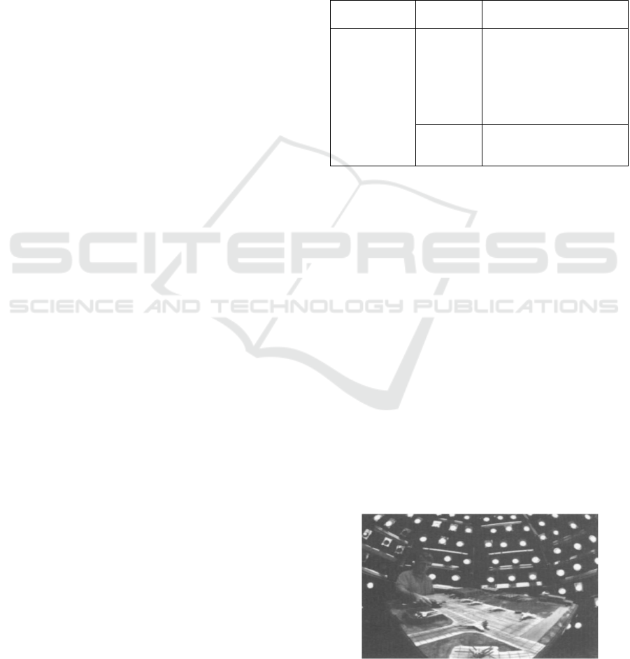
Table 1: Proposed classification of methods.
Analogue
Based
Models /
Dioramas
Francis et al. (1993)
Maver and Scarff (1993)
Computational
Based
Based on
Exiting
Images
Justice et al. (1989)
Esposito et al. (1998)
Boggione et al. (2003)
Chen et al. (2008)
Yang et al. (2009)
Nelson et al. (2009)
Maeda et al. (2008)
Totally
Synthetic
Ientilucci and Brown (2003)
Schott (1997)
Latorre et al. (2002)
2.1 Analogue based
Physical models may include terrain, ground cover,
structures and vehicles, with scene detailing
depending on the resolution of the sensor to be
simulated. This approach is described by Francis et
al. (1993). The scene is illuminated with a collimated
beam to simulate the sun and many diffuse sources to
simulate the sky as shown in Figure 1. The sensors
are located above the model and the optics is adjusted
to simulate the desired field of view. The image in this
case is designed to represent the radiance field in the
sensor. It is also easy to change the camera and the
sun angles to generate multiple images of the same
scene. This methodology has the disadvantage that it
is necessary to ensure that high reflectance and
reflectance variation are included in this scenario.
This problem becomes severe when this approach is
used to simulate multispectral scenes. Maver and
Scarff (1993) describe a hybrid approach to simulate
Figure 1: Simulation using physical model (Schott, 1997).
GISTAM 2018 - 4th International Conference on Geographical Information Systems Theory, Applications and Management
314

multispectral scenes where physical models and
lighting are used to generate scenarios that are then
processed through computer vision.
The advantage of this approach is that some of the
spatial variations and interactions of certain materials
can be included in the design of the model. The
disadvantage is that generating complex scenes can
become difficult, requiring in many cases
considerable manual editing.
2.2 Computational based
This approach involves simulation techniques that
propose methods in which the simulated images are
generated from other images or a synthetic scene.
These techniques typically address the degradation of
a better-resolution image to generate images at worse
resolutions, although there are reverse cases. These
techniques allow to simulate scenes close to reality.
2.2.1 Based on Existing Images
Justice et al. (1989) present aspects of spatial
degradation generating simulated images in six grids
of different resolutions in a range of 79 m to 4000 m
from the Multispectral Scanner / Landsat (MSS)
sensor.
Esposito et al. (1998) present the simulation of the
images of the CBERS cameras, which at the time of
this work had not yet been released, using AVIRIS
(Airborne Visible / Infrared Imaging Spectrometer)
images. It was necessary to extrapolate the spectral
radiance measured by AVIRIS at 20 km altitude to
the altitude of the CBERS orbit at 778 km and the
MODTRAN 3.0 program was used for this
calculation, providing the transmittance values at
each wavelength. For the difference in time taken for
the images (CBERS programmed to pass over the
equator at 10:30 a.m., and the AVIRIS images of the
study were collected between 1:30 p.m. and 4:30
p.m.), and knowing the lighting conditions of the
scene, the solar zenith angle was calculated for both
the AVIRIS transit time and the CBERS transit time,
obtaining a correction factor that was applied
throughout the scene.
Boggione et al. (2003) present the possibility of
simulating a panchromatic band for Landsat 5 from
its spectral bands. In this work the restoration
technique combined with interpolation is used to
generate images in smaller grids. The spectral
question is solved using the relation between areas of
the spectral curves of the bands of Landsat 7 and its
panchromatic.
Chen et al. (2008) propose a simulation method to
acquire simulated hyperspectral images using
spectral low resolution images. The proposed method
uses the idea of pixel mixing to understand the
relation between the spectral values of a pixel of the
image and to simulate the processes of radiation
transmission.
Yang et al. (2009) presents the simulation of high
resolution images in the mid-infrared spectral range
using an analytical model of radiative transfer of the
atmosphere. Unlike other spectral ranges, the average
infrared is highly dependent on atmospheric
dispersion and emissions.
Nelson et al. (2009) who used the simulation of
images to study the effects of resolution in the
estimation of forest areas, simulated images of 90 to
990 meters of resolution from images of 30 meters
resolution of the Landsat system.
Maeda et al. (2008) using the ETM + / Landsat7
image degradation technique and nearest neighbour
resampling simulated and evaluated the potential of
WFI / CBERS-3 images for land use and land cover
classification in two regions with distinct landscape
characteristics.
2.2.2 Totally Synthetic
With DIRSIG model, Ientilucci and Brown (2003)
produced imagery that can be used to test the
performance of spatial and spectral image
exploitation algorithms and concluded that synthetic
data should be considered a powerful tool to assist in
the testing of algorithms and potentially as a surrogate
when real data is not available.
According to Schott (1997), an alternative to the
use of analogue based models is a totally synthetic
approach, where scene elements, radiation
propagation, and sensor effects are simulated using
computational modeling. This approach is more
interesting because it allows infinite variations,
essentially, in the processes of adjustment of scene
elements and interaction. On the other hand, the
computational complexities of this approach in terms
of coding and run time are disadvantages. In practice,
the idea is to accurately model the physical processes
that occur in the process of imaging. The result is a
hi-fidelity model that can provide information about
the imaging process as well as the simulated image
itself. Typically, a model is used to generate an
estimate of the radiation from the target to the sensor.
This model is often associated with a model of
radiation propagation, such as MODTRAN
(MODerate resolution atmospheric TRANsmission)
used to calculate the level of surface radiation in the
Synthetic Images Simulation (SImS): A Tool in Development
315
microwave, near infrared, visible, and ultraviolet
(Latorre, 2002). It is a code that can be used to predict
spectral radiance for various geometries and
atmospheric conditions. Atmospheric propagation
models often have a database of atmospheric
conditions that are needed as input. Finally, a sensor
model must be available to characterize the sensor
location, acquisition geometry, field of view,
resolution, spectral response and radiometric.
3 RESULTS
The development of this simulator (SImS) is centered
in this last proposal (Schott, 1997) and it aims to
generate, from free software and vector cartography,
in an automated way satellite synthetic images. This
simulator presents independence from analogue
based, other images or commercial software which
means that images can be generated from random
scenarios and created according to input parameters
of users, as well as pseudo-synthetic images from
cadastral data for example.
Following this, we select the free software
Blender 2.78 to create tools that generate images
using its integrated Python 3 programming language.
Some strategic decisions are needed to be defined
for the development of SImS and the main ones were:
The indicated free software Blender 2.78 – is
the free and open source 3D creation suite. It
supports the entirety of the 3D pipeline —
modelling, rigging, animation, simulation,
rendering, compositing and motion tracking,
even video editing and game creation. Also
customize the interface layout and colours and
combine 2D with 3D.
Python programming language – Blender has a
flexible Python controlled interface and layout,
colours, size and even fonts can be adjusted as
well as it is possible create own using Blender's
accessible Python API.
Geospatial Data Abstraction Library (GDAL) -
is a translator library for raster and vector
geospatial data formats and the gdal_edit.py
script can be used to edit in place various
information of an existing GDAL dataset
(projection, geotransform, metadata).
OpenCV - is the computational view in which
we can use computational algorithms to
describe and analyze the content of any image.
It is free for academic use and it has Python
interface and support Windows.
Object format - the Wavefront .obj file is a
simple data-format and it is considered a
"universal format" for 3D object
representation. It is represented in ASCII
format and recognized by most 3D
modelling/visualization software.
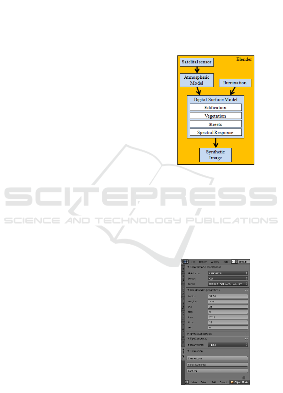
The conceptual model of the main modules can be
seen in Figure 2.
Figure 2: Conceptual model.
The main parameters to be inserted in the satellite
sensor module should allow the definition of the
program, platform and sensor from a library of
satellite platforms. Their spatial position will be
obtained from their own orbital parameters or
ephemeris.
Currently, the parameters that the user can define
are those shown in Figure 3. In this figure, Band 2 of
the OLI sensor (Operational Land Imager), Landsat 8
is highlighted as spectral information to be simulated.
Figure 3: Simulator toolbar.
GISTAM 2018 - 4th International Conference on Geographical Information Systems Theory, Applications and Management
316
Information such as the geographical coordinates
(latitude, longitude), date, time and types of roads can
also be defined.
The Illumination module consists of simulating
the behaviour of incident solar rays in a raytracing
system compatible with reality.
The Atmospheric Model module, also comes from
a library to be implemented, will aim to predict in a
simple way only the dynamic state of the atmosphere.
These simple model will be defined only for RS
purpose and will not suitable for weather or climate
forecasting.
With regards to the module Digital Surface Model
(MDS), in development, automatically and according
to a user’s defined criteria, different layout of streets,
blocks, vegetation and buildings are textured.
Nowadays, this model allows to simulate static textures
defined from the ASTER Spectral Library (Baldridge
et al. 2009) like Construction Asphalt, Construction
Concrete, Conifer and Aluminium Metal, respectively.
Developing importers of MDS and spectral libraries
are the future stage, mapping validity will ensure
greater variability of 3D scenarios.
The synthetic image will also be associated with a
synthesis metadata file. Nowadays, the export module
allows to create a synthetic image and in its future
version, it will create a text file with the creation
parameters that corresponds to the end of the creation
process.
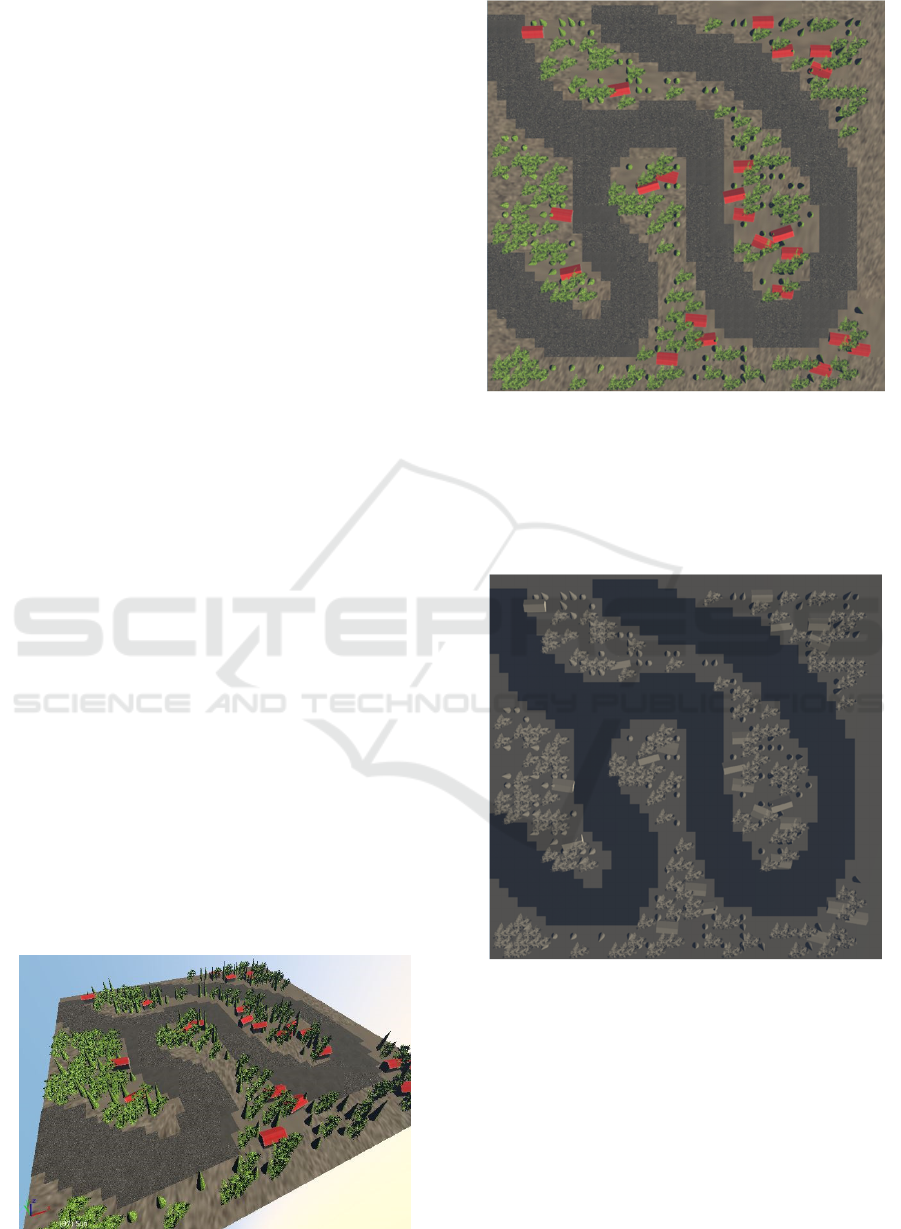
Figure 4 and 5 show, respectively, a simulated
scenario in its real appearance given the pre-defined
geographical and lighting conditions, and the sensor
display in nadir position (upper view). The
parameters defined as follows:
Latitude: 37.78º
Longitude: 3.78º
Day: 25
Month: August
Year: 2017
Hour: 1000
UTC: 2
Figure 4: Simulated scenario (real appearance).
Figure 5: Simulated scenario (upper view).
Finally in order to show the versatility and
potentiality of the simulator, Figure 6 shows the same
image that corresponds to the OLI sensor, Landsat 8,
Band 5 Near-Infrared (0.85 - 0.88 μm), but with a
spatial resolution of approximately 1m and not 30m.
Figure 6: Simulated scenario (upper view).
4 CONCLUSIONS
In this paper we described the present state of a
software and its model to create synthetic images
from the simulation of a 3D scenario.
The development of this tool, based on free
software and using independent sources of
geographical information, allows the user to generate
a scene in which it is able to control all the stages of
Synthetic Images Simulation (SImS): A Tool in Development
317

creation and to obtain an image as similar as possible
to what would obtain a real system. In this sense, the
simulator tries to generalize its use to different
disciplines.
Currently the user is allowed to define day, month,
year, time, latitude, longitude, streets, structures and
vegetation for the random creation of a scenario that,
with probabilities or specific quantities of objects, can
be exported in the respective spectral and spatial
resolutions of interest.
Moreover, the present tool allows the user to
define the desired spectral band and spatial
resolution. This flexibility is fundamental to the make
SImS a universal tool. For this reason, as an example,
images corresponding to the OLI (Landsat 8) sensor
spectral resolutions were presented in this paper.
Our future work will consist of integrating other
elements of the territory, such as elevation models
and different atmospheric models with different
meteorological parameters. In this way it will be
possible to parameterize sensors and platforms for the
effective integration in the generation of synthetic
images, considered by the countries strategic factor.
ACKNOWLEDGEMENTS
The authors acknowledge the Regional Government
of Andalusia (Spain) for the financial support since
1997 for their research group (Ingeniería
Cartográfica) with code PAIDE-TEP-164 and the
Department of Science and Technology of the
Brazilian Army.
REFERENCES
Alarcon, V. J. and Sassenrath, G. F. 2004. Cotton crop
spectral imaging analysis: a web-based hyperspectral
synthetic imagery simulation system. In: Remote
Sensing and Modeling of Ecosystems for Sustainability,
(Gao, W. and Shaw, D.R., Eds.). Proceedings of SPIE,
Vol. 5544, 178-185.
Baldridge, A. M., S. J. Hook, C. I. Grove and G. Rivera,
2009.. The ASTER Spectral Library Version 2.0.
Remote Sensing of Environment, vol 113, pp. 711-715.
Boggione, G. A.; Pires, E.G; Santos, P. A; Fonseca, L. M.
G. Simulation of Panchromatic band by spectral
combination of multispectral ETM+ bands.
International Symposium on Remote Sensing of
Environment (ISRSE), Hawai, Nov. 2003.
Chen, F.; Niu, Z.; Sun, G.; Wang, C.; Tang, J. Using low-
spectral-resolution images to acquire simulated
hyperspectral images. International Journal of Remote
Sensing, v. 29, p. 2963-2980, 2008.
Esposito, E. S. C. Simulação das bandas espectrais das
câmaras CCD e WFI do satélite CBERS, a partir de
dados do sensor hiperespectral AVIRIS. versão: 1970-
01-01. Dissertação (Mestrado em Sensoriamento
Remoto) - Instituto Nacional de Pesquisas Espaciais,
São José dos Campos, 1998.
Francis, I; Maver, L.; Schott, J.R. Comparison of physically
and computer generated imagery. Proceedings SPIE, v.
1904, p. 20-23, 1993.
Ientilucci, E.J.;Brown, S.D. Advances in Wide Area
Hyperspectral Image Simulation. Proceedings of SPIE
Vol. 5075 (2003).
Justice, C. O.; Markhan, B. L.; Townshend, J. R. G.;
Kennard, R. L. Spatial degradation of satellite data.
International Journal of Remote Sensing, v. 10, n. 9, p.
1539-1561, 1989.
Latorre, M.; Abílio, O.; Júnior R, D. C.; Paula, A.;
Carvalho, F. D.; Shimabukuro, Y. E. Correção
Atmosférica: Conceitos e Fundamentos. Espaço &
Geografia, v.5, n. 1, p. 153-178, 2002.
Maeda, E. E.; Arcoverde, G. F. B.; Formaggio, A. R.;
Shimabukuro,Y. E. Evaluation of the potentiality of
WFI/CBERS-3 Sensor data for land use and land cover
classification. Revista Brasileira de Cartografia, v. 1,
n. 60, p. 79-87, 2008.
Marcal, A. R. S.; Rodrigues, A.; Cunha, M. "Evaluation of
satellite image segmentation using synthetic images,"
2010 IEEE International Geoscience and Remote
Sensing Symposium, Honolulu, HI, 2010, pp. 2210-2213.
Nelson, M. D.; McRoberts, R. E.; Holden, G. R; Bauer,
M.E. Effects of satellite image spatial aggregation and
resolution on estimates of forest land area.
International Journal of Remote Sensing, v. 30, n. 8, p.
1913-1940, 2009.
Maver, L.; Scarff, L. Multispectral image simulation.
Proceedings SPIE, v.1904, p. 144-160, 1993.
Sassenrath, G. F., Alarcon-Calderon, V. J., Pringle, H. C.
2003. “Synthetic imagery of cotton crops: Scaling from
leaf to full canopy.” Digital Imaging and Spectral
Techniques: Applications to Precision Agriculture and
Crop Physiology. T. van Taoi, ed.. pp. 111-133.
Agronomy Society of America Special Publication
Number 66, Madison, WI.
Schott, J. R. Remote sensing the image chain approach.
New York, NY: Oxford University, 1997 394305169.
Schott, J.R.; Raqueno, R.V.; Raqueno, N.G.; Brown, S. D.
A Synthetic Sensor/Image Simulation Tool to Support
the Landsat Data Continuity Mission (LDCM). In
Proceedings of ASPRS 2010 Annual Conference, San
Diego, CA, USA, 26–30 April 2010.
Schott, J.; Gerace, A.; Brown, S.; Gartley, M.; Montanaro,
M.; Reuter, D.C. Simulation of Image Performance
Characteristics of the Landsat Data Continuity Mission
(LDCM) Thermal Infrared Sensor (TIRS). Remote
Sens.2012, 4, 2477-2491.
Yang, G.; Liu, Q.; Liu, Q.; Huang, W.; Wang, J. Simulation
of high-resolution mid-infrared (3–5 mm) images using
an atmosphere radiative transfer analytic model.
International Journal of Remote Sensing, vl. 30, n. 22,
p. 6003–6022, 2009.
GISTAM 2018 - 4th International Conference on Geographical Information Systems Theory, Applications and Management
318
