
Location Intelligence for Augmented Smart Cities Integrating Sensor
Web and Spatial Data Infrastructure (SmaCiSENS)
Devanjan Bhattacharya and Marco Painho
Nova Information Management School, Universidade Nova de Lisboa, Lisbon, Portugal
Keywords: Spatial Data Infrastructure, Sensor Web, Geographical Information System, Smart Cities, Knowledge Based
System, Expert System, Spatial Technologies.
Abstract: Spatio-temporal aspects of data lead to critical information. Sensors capture data at all scales continually so
it is imperative that useful information be extracted ubiquitously and regularly. Location plays a vital part by
helping understand relations between datasets. It is crucial to link developmental works with spatial attributes
and current challenge is to create an open platform that manages real-time sensor data and provides critical
spatial analytics atop expert domain knowledge provided in the system. That is a two-faced problem where
the solution tackles not only data from multiple sources but also runs data management platform, a spatial
data infrastructure(SDI) as backbone framework able to harness sensor web(SW). The paper proposes
development of such a globally shared open spatial expert system(ES), SmaCiSENS, a first of a kind geo-
enabled knowledge based(KB) ES for multiple fields, smarter cities to climate modeling. SmaCiSENS is
integration of SW and SDI with domain KB on data and problems, ready to infer solutions. The paper
describes an architecture for semantic enablement for SW, SDI; connect interfaces, functions of SDI and SW,
and sensor data application program interfaces (APIs) to better manage climate modeling, geohazard, global
changes, and other vital areas of attention and action.
1 INTRODUCTION
Everything happens somewhere and some-whence.
Spatial and temporal aspects of data lead to critical
insights into the information contained in it.
Nowadays it is increasingly imperative to capture
data at all spatial scales, local to global, and extract
useful information from it ubiquitously and regularly.
For the information to have an impact, it should be
extracted in real-time or as near to real-time as
possible. It is where location plays a vital part by
rendering meaningful ways of understanding
relationships between datasets quickly.
The benefits of associating all developmental
works with spatial attributes is universally
acknowledged now, hence the next big leap will be to
research a platform that manages real-time sensor
data and provides critical spatial analytics. Both the
aspects are size intensive and time consuming so an
automated, compartmentalized yet integrated
solution is the optimal way forward. The research
creates background for describing a spatially aware
sensor web SmaCiSens, a system for smart city
enhancements and interdisciplinary processes for
sustainable development. It proposes a
multidimensional distributed spatial platform using
open source geo-datasets which involves web-
geoinformatics for creating schema and interface for
mapping under Open Geospatial Consortium (OGC)
standards by interlinking models and datasets. Spatial
systems are needed for real time analysis and
information on events and developments through
Open Source Geographical Information System (OS-
GIS) platform.
Location is involved with everything, hence a
spatial system is vital for better urban information
management and spatial data infrastructure(SDI)
creation. This also benefits when huge databases are
created and consulted regularly for region planning at
different scales through satellite images and maps of
locations. There is need for spatially referenced data
creation, analysis, and management. The paper
describes existing state-of-the-art towards
development of a system with sensor-web(SW)
access utilizing geomatics for sustainable societies.
There has been a need to develop automated integral
spatial systems to sense and categorize events and
issue information that reaches users directly. At
present, no web-enabled spatial sensor information
system exists which can disseminate messages after
282
Bhattacharya, D. and Painho, M.
Location Intelligence for Augmented Smart Cities Integrating Sensor Web and Spatial Data Infrastructure (SmaCiSENS).
DOI: 10.5220/0006786102820289
In Proceedings of the 4th International Conference on Geographical Information Systems Theory, Applications and Management (GISTAM 2018), pages 282-289
ISBN: 978-989-758-294-3
Copyright
c
2019 by SCITEPRESS – Science and Technology Publications, Lda. All rights reserved

events evaluation in real time. The research work
formalizes a notion of an integrated, independent,
generalized, and automated geo-event analyzing
system making use of geo-spatial data under popular
usage platform. Integrating SW with SDI enables to
extend SDIs with sensor web enablement (SWE),
converging geospatial and built infrastructure, and
implement test cases with sensor data and SDI.
The previous works in this domain either
focused on SDI and described an application, or on
sensor web describing its application, mainly
suggesting the development of such ideas but have
not created an integrated system generalized enough
for multi-case use. Most such theories have put
forward specific instances of usability and hence the
research has stopped at that. The current work
describes the research gaps that could be overcome by
the development of a generalized system
SmaCiSENS and the broader research benefits arising
out of the endeavor. The aim is to create a generalized
location enabled platform for use-cases analysis in
smart cities environments ranging from automated
natural hazard monitor webGIS with internet-SMS
warning, climate monitoring, to urban design,
intelligent transportation systems, disaster
management SDI.
2 BACKGROUND
Systems have been proposed to handle the seemingly
infinite and continuous data being generated but have
fallen short of universal adoption due to several
reasons, apart from lacking domain knowledge hence
not being decisive, being offline or disconnected, case
specific, temporally disjoint, and unintegrated.
Further, to be fully accepted as a system the solution
should provide decision-making information in least
supervised manner. It should have some degree of
autonomous functionality. With the advent of digital
initiatives and information technology (IT)
implementations like internet of things (IoT) and
sensors, administrations today are faced with a
challenge of large volumes of unstructured data
coming from multiple disparate sources which are
difficult to make sense of. Traditional systems report
problems but are not capable of “showing them”,
which adds to the troubles of the administration in a
situation where they are flooded with high volume
data constantly. In many cases by the time
administration has figured out the exact location
along with an action plan, the ground situation would
have already changed.
With the advent of sensors for monitoring,
data collection is ubiquitous are at unprecedented
levels. The enormous volumes of data being collected
constantly, create mounting challenges for optimal
data processing and information retrieval (Janowicz
et al., 2010). Furthermore, the spatial aspect of data is
being largely underutilized in processing, although
the importance of spatial decision-making is now
widely accepted (Nativi and Bigagli, 2009). It has
been proven that spatial analysis of data gives more
meaning to the information extraction and hence
enables easier assimilation of large volumes of data
(Reed and Reichardt, 2008). Presently the systems
that implement such processes are limited in effect by
not utilizing all the data due to their standalone
nature, offline or disconnected design, lack of spatial
capabilities, unintegrated approach, and temporally
disjoint.
For example, in spatial data processing the
major hurdles are that the different research groups
globally are processing their data in silos, most of the
time repeating same processes at each location,
creating similar metadata each time, duplicating data,
thereby falling behind the rushing stream of more
incoming data (Taylor and Parsons, 2015). The
solution could be addressed through integrating: data
source, spatial data platform, data understanding,
knowledge base, inferencing and visualization into a
single, well-connected online real-time system. Such
a spatial expert system(ES) with knowledge
bases(KB) will not only serve the critical research of
spatializing developmental works but do so to any
research relying on real-time data capture and
analysis with spatial domain of data being the unique
enabler. Several important sources over the years
have heavily stressed the need for developing a
system capable of encapsulating the entire essence of
geospatial studies in one platform which can be open,
shareable, knowledgeable, and contributable globally
(Maguire and Longley, 2004).
Spatial data are dramatically increasing in
volume and complexity, just as the users of these data
in the scientific community and the public are rapidly
increasing in number (Laurini, 2017). A new
paradigm of more open, user-friendly data access is
needed to ensure that society can reduce vulnerability
to spatial data variability and change, while at the
same time exploiting opportunities that will occur
(Bröring et al., 2011). The burgeoning types and
volume of spatial data alone constitute a major
challenge to the spatial research community. As a
result, spatial scientists must not only share data
among themselves, but they must also meet a growing
obligation to facilitate access to data for those outside
Location Intelligence for Augmented Smart Cities Integrating Sensor Web and Spatial Data Infrastructure (SmaCiSENS)
283

their community and, in doing so, respond to this
broader user community to ensure that the data are as
useful as possible (Bishop, 2015). Although research
scientists have been the main users of these data, an
increasing number of resource managers need and are
seeking access to spatial data to inform their
decisions, just as a growing range of policy-makers
rely on spatial data to develop spatial change
strategies. With this gravity comes the responsibility
to curate spatial data and share it more freely,
usefully, and readily than ever before (Chen et al.,
2015).
Almost every decision that an individual or
organization makes has some geospatial component.
Almost any piece of information stored in a database
has a location attribute. Sensor web(SW) and spatial
data infrastructures(SDI) show great promise for
building and maintaining a sustainable and changing
society (Giuliani et al., 2017), which often needs to
acquire spatial data through sensors and extract
information using data analysis from SDI for better
decision-making. The full potential of SW and IoT
can only be reached with spatial intelligence
integrated to them (Mayer and Zipf, 2009). The
geospatial industry is also trying to ride the big wave
and exploit the market (Li et al., 2015). Moreover the
concept of geo-data democratization is gaining
momentum and is being described as the next big
disruption (Pantazis et al., 2011). But the long-term
solution has eluded everybody so far and only case
specific systems are being designed. Hence the
motivation in SmaCiSENS is to develop a system
using the core spatial technologies of SDI integrated
with SW and IoT through standard architectures and
utilising expert domain KBs.
To study a system designed on SDI, spatial
KBs and SW, one has to survey each of them
separately since hardly an integrated system exists
(Bhattacharya and Painho, 2017). Considerable
research and development has been carried out in SDI
in past years (Bhattacharya et al., 2017). For example,
Global Earth Observation System of Systems
(GEOSS, 2017), enviroGRID, 2017, and
COPERNICUS, 2017, provide high quality spatial
data to users in user-friendly geo-visualization
platforms. The Infrastructure for Spatial Information
in Europe, INSPIRE, 2017, adopts service
technologies for building its spatial information
infrastructure. Other systems are high-level
middleware services and domain-specific services for
problem-solving and scientific discovery in
infrastructures. For example, the Group on Earth
Observation (GEO) Model Web initiative proposes to
provide environmental models as services and
integrating distributed models in infrastructures. Data
provenance is added into SDI to capture and share the
derivation history of geospatial data products, which
is important in evaluating the quality of data products.
Others propose the ontology approach for geospatial
resource discovery in SDI. The Open Geospatial
Consortium (OGC) is leading and coordinating the
efforts of international organizations and enterprises
to develop interoperable geospatial services. A series
of standard-based interface specifications are already
available, including Web map services (WMS), Web
feature service (WFS), Web coverage services
(WCS), catalogue services for the Web (CSW), and
Web processing service (WPS).
Research on the spatial capabilities
enhancement of sensor web, in a limited manner, are
reported in Liang and Huang, 2013. There are some
ongoing activities that are defining architectures and
best practices for integrating sensor networks and
observed data into existing and new SDI applications
eg. Sensor Systems Anywhere, (SANY, 2009), as a
Framework Programme 6 (FP6) integrated project
focuses on interoperability of in-situ sensors and
sensor networks. An instance of utilizing sensor web
with spatial knowledge was reported in Liang and
Huang, 2013 where a system was developed to
provide a graphical user interface to sensor data and
provisions for spatial reference to that data. The
research in Liang et al., 2005 reported a primitive
system of sensor and web mapping was discussed that
worked on web mapping interfaces. SmaCiSENS
goes much ahead of such efforts by combining
various research threads into one system having
semantic KB robustness for a variety of data formats
and sources, generalized interfaces for connectivity to
spatial functions, a comprehensive and extensive SDI
framework, and real-time data capture and
processing.
SmaCiSENS can have a real edge over the
currently under development projects of similar kind
in terms of impact on urban development, hazard
management and mitigation, digital mapping,
location based services, core services and much more.
Moreover, the ever-increasing repository of data are
held in silos and are not shareable. The apprehension
of losing data integrity also hinders the process of
sharing. Typically, the fault is put on lack of easy
tools to do that. Hence, we are looking at a two-faced
problem where the solution would have to tackle not
only data from multiple sources but also provide data
management platform. Such a system would
invariably need a spatial data infrastructure (SDI) as
its backbone framework. And it should be able to
harness the sensor web. Essentially the system would
GISTAM 2018 - 4th International Conference on Geographical Information Systems Theory, Applications and Management
284

call for an integration of Sensor Web(SW) and SDI.
Both SDI and SW are web-enabled so by the logic of
extension it should be possible to connect SDI and
sensor web. With the inclusion of domain knowledge
base (KB) about the data and problems the system
becomes ready to infer solutions. And the solution not
only helps with administration, the situation holds
true with many other areas of immediate attention and
action, like climate modeling, geohazard
management, global changes that are taking place, all
these and more, have huge spatial implications that
could be understood quickly with location
intelligence through a geo-enabled expert
system(GES). The best solution is implementation of
a spatial knowledge based expert system (Laurini,
2017).
Geo-visual platforms discussed in Mayer and
Zipf, 2009. integrated sensors with SDI for creating
3D city view. But the work only applied to a few
specific sensor datasets. The generalized integration
of sensor web and SDI has been reported by Bröring
et al., 2011 and the papers elaborate on the underlying
logics. A geosensor web concept has been discussed
in Maguire and Longley, 2004 with SDI in
background but the discussion is theoretical and the
development aspects from this theory have been put
together by (Bhattacharya and Painho 2016) setting
the tone for SmaCiSENS. Further, the semantic
requirements of a spatial system have been suggested
in Janowicz et al., 2010.
A detailed deployment of enhanced SDIs is
presented in (Chen et al., 2015) where the need for
scalability of ontologies to spatial datasets is proven.
In another related publication, the interlinking of
open geodata sets has been described (Taylor and
Parsons, 2015) and the functional and usable
enhancements are proven. A proof of concept funded
by NASA has described a geospatial sensor web
architecture (United Nations, 2010) but it has not
been fully developed yet, pointing to the importance
of the vision which has been picked up by this
proposal addressing SmaCiSENS. Distributed
architectures for socio-economic spatial studies have
been proposed by (Nativi and Bigagli, 2009) but a
developed system has not been realized yet.
Several schemas for cyberinfrastructure have
been reported (Liang and Huang, 2013; 2005) but the
development is still to be done. According to Laurini,
2017 the main reason such a system as SmaCiSENS
has not been achieved yet is the difficulty to merge
spatial geometry and topology inherently with
traditional analysis and create an effective spatial
inference engine. But through this research work the
solution is demonstrated in creating algorithms and
ontologies utilizing geometry, topology, and location
arithmetic and shown that SmaCiSENS can be the
system to address all the challenges.
The research questions that have been discussed
through the present work are: i) how to build open
source spatial ontologies for spatial phenomenon
using causative factors ii) how to connect ontologies
to intelligent inferencing logics iii) how to build
specialized knowledge bases for a generalized spatial
KBES iv) how to apply the system to automate
procedures viz. urban and natural v) how to integrate
sensor web(SW), other data sources and spatial data
infrastructure(SDI) with open source technologies.
SmaCiSENS aims to address these challenges
through developing a framework that houses data,
metadata, understanding of the data, knowledge to be
applied on the data, and output from the data.
SmaCiSENS would enable a distributed spatial
framework that targets to deliver spatial decisions to
start with but would administer spatial functionalities
to a variety of social needs.
3 METHODOLOGY
The methodology of development of SmaCiSENS is
modular in structure (Fig. 1). The overall architecture
depends on the creation of knowledge bases for
natural hazards (or any event) to deduce the specifics
of the occurrence. The methodology is that the input
module of the system implements extraction, based
on legend matching, of information about causative
factors from thematic maps, satellite images, and GIS
layers. Understanding module addresses expert
knowledge rules (qualitative approach) in expert
module, which conducts pixel-based reclassification
of input (compatible to KB), results in evaluation of
intensity/effect of hazard(any situation) on ratings of
causative factors (deterministic method) out from
Output module and communication to user is
achieved through Communication module which also
gives feedback to improve inputs and geospatial
information improvement, since GIS module has bi-
directional data flow. The interactive graphical user
interface (GUI) allows for data visualization,
manipulation and sharing.
Open-Source Geographical Information
System (OS - GIS) and distributed architecture based
platform such as GeoNode allows 3-dimensional
(3D-GIS) development. To develop on an open
source platform is extremely vital when huge
databases are to be created and consulted regularly for
region planning at different scales particularly
satellite images and maps of locations (Bhattacharya
Location Intelligence for Augmented Smart Cities Integrating Sensor Web and Spatial Data Infrastructure (SmaCiSENS)
285
and Painho 2016). There is a big need for spatially
referenced data creation, analysis and management.
Some of the salient points of SmaCiSENS are that
GeoNode is an open source platform facilitating the
creation, sharing, and collaborative use of geospatial
data (Figure 2). The project aims to surpass existing
spatial data infrastructure solutions by integrating
robust social and cartographic tools; at its core, the
GeoNode is based on open source components
GeoServer, GeoNetwork, Django, and GeoExt that
provide a platform for sophisticated web browser
spatial visualization and analysis.
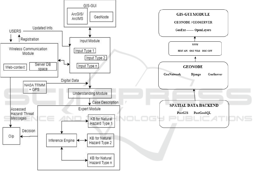
Figure 1: Schema SmaCiSENS modular architecture & data
flow.
The elements of Sensor Web Enablement (SWE)
services could be understood as:
• a service for retrieving sensor 'observation' data and
meta-information, the so-called 'Sensor Observation
Service' (SOS); • a service for sensor planning and
executing tasks, called the 'Sensor Planning Service'
(SPS); • a service that allows users to subscribe to
specific alert types, known as the 'Sensor Alert
Service' (SAS); • a service that facilitates
asynchronous message interchange between users
and services, and between two OGC-SWE services,
called the 'Web Notification Service' (WNS). And
that of web mapping (SDI) services: Web Map
Service (WMS); Web Feature Service (WFS); Web
Coverage Service (WCS); Web Map Context
(WMC); Catalogue; Metadata. It is necessary to have
a one-to-one correspondence between the elements of
Sensor Web and SDI. A possible environment for
establishing such interfaces could be GeoServer and
GeoNode which provide an OGC compatible data
store that can speak WMS, WFS, WCS and others in
common formats like GML, GeoJSON, KML and
GeoTiff. It can be connected to different spatial
backends including PostGIS, Oracle Spatial, ArcSDE
and others.
Figure 2: The Geonode architecture used in Figure 1.
The Catalog, GeoNetwork, provides a standard
catalogue and search interface based on OGC
standards. It is used via the CSW interface to create
and update records when they are accessed in
GeoNode. It talks to the other components via HTTP
and JSON as well as standard OGC services
(Bhattacharya and Painho 2017, 2016). The
integration of sensor web and SDI in open source
domain could be achieved possibly by setting up one
to one correspondence between their services through
functions calling and methods calling.
The main research is on the inclusion of spatial
components of geometry and topology with
conventional analysis. Through the inclusion of SDI,
spatial KBs, and spatial inference engine the goal of
a spatial expert system can be achieved. The
framework would work on open technologies such as
GeoNode, GeoServer, Apache Kafka/Storm/Hadoop,
Apache CloudStack, Open Street Map, PostgreSQL,
PostGIS, Java, QGIS, TeraData, Presto, SPARQL,
GISTAM 2018 - 4th International Conference on Geographical Information Systems Theory, Applications and Management
286
Python, CKAN, RDF, OWL and MongoDB to
manage the top level, middle level and lower level
architecture (Fig. 3). This architecture makes a
distributed spatial system possible where the location
knowledge is advanced by utilising databases and
ontologies(Fig. 4).
Figure 3: Capturing sensor web for SmaCiSENS.
The topological and geometric matching of big open
data has been achieved in a moderately non-trivial
case as reported in (Bhattacharya and Painho 2017).
Additionally the ontological representation of natural
phenomenon for expert systems has been developed
for specific cases. The object-oriented ontological
framework has been planned to be hybrid of object-
based and rule-based as reported by Pantazis, 2011.
The feasibility analysis behind SmaCiSENS involves
significant works on the spatial data analysis
algorithms (Bhattacharya and Painho 2017) which
benefit from the semantic logic being robust and
research through SmaCiSENS has to proceed in
similar directions. Also related works on user
generated spatial data and crowd sourced VGI prove
the need for integrated platform for spatial analysis
(Laurini, 2017). The developmental research work
under the proposal draws methodologies from the
following previous works and delivers functionalities
such as: integrating in a single platform multiple
spatial data sources with analytics capabilities
(Bhattacharya and Painho 2016); maintaining a
spatial knowledge base with inferencing capabilities
(Bhattacharya and Painho 2017); integrating sensor
web with spatial data infrastructure (Liang and
Huang, 2013); providing a platform for visualizing
and testing different models (Liang et al., 2005);
distributed processing of spatial big data.
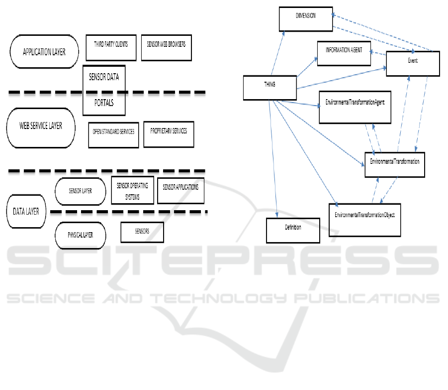
Figure 4: Sample ontology for Things (IoT).
4 DISCUSSIONS
SmaCiSENS will deliver the current state-of-the-art
with respect to sensor web data utilization and spatial
data infrastructure (SDI) applications for
developmental activities in smart cities. Further it is
seen that singly as a technology sensor web as well as
SDI each is stagnating on their own. The need at
present is to explore possibilities of merging the two
so that each can feed on the strengths of each other
and synergize their respective fields. For the future
smart cities this could be a huge advantage as we look
towards harnessing the potential of ubiquitous sensor
data through intelligent apps. The apps would get a
ready framework in SmaCiSENS for data sources as
well as spatial processing platform with cloud,
virtualization and data federation capabilities. It is
evident that within a short time, the vast majority of
all geospatial content will be from sensor networks
and systems, with the volume of available sensed
content orders of magnitude larger than at present.
SmaCiSENS poses a very big challenge but it is high-
gain as well. The provision of a fail-safe process is
also there, just in case, where we develop
Location Intelligence for Augmented Smart Cities Integrating Sensor Web and Spatial Data Infrastructure (SmaCiSENS)
287

SmaCiSENS on the specific applications dataset
only.
Optimal decision making relies not only on the
ability to fuse and apply core geospatial information,
but also the ability to discover, access and apply real
time information from sensors and sensor networks.
A gamut of information about the environment - land,
air, water, weather, climate and natural and man-
made risks can be harnessed by seamless and rapid
access to sensors. In addition, sensors are critical
components of building, transportation, utility and
industry infrastructure.
The ability to harness and render this
information in a location context is a major challenge.
Until recently though, there were no facilitating
standards to make it easier to discover, access and
integrate this information. Therefore, a consistent set
of encoding and interface standards are mandatory for
adapting and integrating sensor networks into an SDI
application. Both, SDI (web mapping) standards and
sensor web enablement standards from OGC, have to
meet at a common ground and connect together. The
integration of sensor web and SDI in open source
domain could be achieved possibly by setting up one
to one correspondence between their services through
functions calling and methods calling.
SmaCiSENS can deliver an integrated sensor
web and SDI which can solve a lot of challenges that
stand-alone, disconnected, case-specific, and
customized systems lack. The next level of capability
for both SDI and sensor web would be to evolve into
a new realm of a location enabled and semantically
enriched Geospatial Web or Geosemantic Web but
additionally with spatial analytics capabilities. The
integration can be done through merging the common
OGC interfaces of SDI and Sensor Web. Through
SmaCiSENS, Sensor Web and SDI are going to keep
expanding in the next decade. Sensors are going to be
so ubiquitous that similar to the world wide web the
addition of vast number of sensors will keep
happening like new data sources of present internet.
The concept of SmaCiSENS has to keep evolving to
help overall development.
5 CONCLUSIONS
SmaCiSENS addresses smarter living conditions for
citizens and better management of resources for
administrators and industries by spatially enabling the
new data sources coming up. Currently the vast
capacity of spatially referencing newer sources of
data and information is not being done. SDI concept
has hit a roadblock towards further development.
One very smart and efficient way forward is to
integrate SDI with new data sources sensors that are
coming up and creating a sensor web of spatially
oriented information. The results of data processing
and infrastructure building will be of interest to
current and future stakeholders so that has to be
formulated according to the university rules.
Expected users will be scientists developing systems
like EU INSPIRE directives, OGC, ISO, public users
and other agencies.
SmaCiSENS can have very attractive market
and research and academic scope in spatial
developments. Applicable to virtually all activities of
commerce and governance. Sensor Web and SDI are
going to keep expanding in the next decade. It is
envisioned that sensors are going to be so ubiquitous
that like the WWW the addition of vast number of
sensors will keep happening like new data sources of
present internet. The concept of SmaCiSENS has to
keep evolving step by step in the years to come to help
overall development of a nation. The future scope is
immense for a system such as SmaCiSENS what with
various applications such as defense application of
analyzing different sensor data; health applications of
medical sensor data; and last but not the least, spatial
change studies globally.
ACKNOWLEDGEMENTS
D. Bhattacharya has been funded by the European
Commission through the GEO-C project H2020-
MSCA-ITN-2014, Grant Agreement number 642332,
http://www.geo-c.eu/.
REFERENCES
Bhattacharya, D. and Painho, M.(2017). Smart Cities
Intelligence System (Smacisys) Integrating Sensor Web
With Spatial Data Infrastructures (SENSDI), ISPRS
Ann. Photogramm. Remote Sens. Spatial Inf. Sci., IV-
4/W3, 21-28, https://doi.org/10.5194/isprs-annals-IV-
4-W3-21-2017.
Bhattacharya, D., Painho, M., Mishra, S., and Gupta, A.
(2017). Mobile Traffic Alert And Tourist Route
Guidance System Design Using Geospatial Data, Int.
Arch. Photogramm. Remote Sens. Spatial Inf. Sci.,
XLII-4/W3, 11-18, https://doi.org/10.5194/isprs-
archives-XLII-4-W3-11-2017.
Bhattacharya, D. and Painho, M. (2016). Design For
Connecting Spatial Data Infrastructures With Sensor
Web (SENSDI), ISPRS Ann. Photogramm. Remote
Sens. Spatial Inf. Sci., III-4, 33-39, doi:10.5194/isprs-
annals-III-4-33-2016, http://www.isprs-ann-
GISTAM 2018 - 4th International Conference on Geographical Information Systems Theory, Applications and Management
288

photogramm-remote-sens-spatial-inf-sci.net/III-
4/33/2016/.
Bishop, J. (2015). Geo-Intelligence and Visualization
through Big Data Trends. IGI Global, Advances in
Geospatial Technologies Series, DOI: 10.4018/978-1-
4666-8465-2.
Bröring, A., Echterhoff, J., Jirka, S., Simonis, I., Everding,
T., Stasch, C., Liang, S., Lemmens, R. (2011). New
generation Sensor Web Enablement. Sensors.
http://doi.org/10.3390/s110302652.
Chen, N., Xiao, C., Pu, F., Wang, X., Wang, C., Wang, Z.,
and Gong, J. (2015). “Cyber-physical geographical
information service-enabled control of diverse In-Situ
sensors,” Sensors (Switzerland), vol. 15, no. 2, pp.
2565–2592.
COPERNICUS, (2016). Global Monitoring for
Environment and Security, is the European Programme
for the establishment of a European capacity for Earth
Observation, www.copernicus.eu (last accessed 11
July 2017).
enviroGRIDS, (2012). Building Capacity for a Black Sea
Catchment Observation and Assessment System
supporting Sustainable Development,
http://portal.envirogrids.net/;
http://portal.envirogrids.net/ (last accessed 11 July
2017).
GEOSS, (2017). Global Earth Observation System of
Systems(GEOSS)- intergovernmental Group on Earth
Observations (GEO),
https://www.earthobservations.org/geoss.php (last
accessed 11 July 2017).
Giuliani, G., Nativi, S., Obregon, A., Beniston, M., &
Lehmann, A. (2017). Spatially enabling the Global
Framework for Climate Services: Reviewing geospatial
solutions to efficiently share and integrate climate data
& information. Climate Services.
http://doi.org/10.1016/j.cliser.2017.08.003.
INSPIRE, (2014). Infrastructure for Spatial Information in
Europe,
http://inspire.ec.europa.eu/reports/ImplementingRules/
network/INSPIRE_NETWORK_SERVICES_SOAP_
Framework.pdf.
Janowicz, K., Schade, S., Broring, A., Kessler, C., Maue,
P., & Stasch, C. (2010). Semantic enablement for
spatial data infrastructures. Transactions in GIS, 14(2),
111–129. Retrieved on 19/05/2017
http://doi.org/10.1111/j.1467-9671.2010.01186.x and
http://carsten.io/tgis09_sel.pdf.
Laurini, R. (2017). Geographic Knowledge Infrastructure:
Applications to Territorial Intelligence and Smart
Cities, 1st Edition, iSTE Press, Elsevier, p. 312.
https://www.elsevier.com/books/geographic-
knowledge-infrastructure/laurini/978-1-78548-243-4.
Li, W., Song, M., Zhou, B., Cao, K., and Gao, S. (2015).
“Performance improvement techniques for geospatial
web services in a cyberinfrastructure environment - A
case study with a disaster management portal,”
Comput. Environ. Urban Syst., vol. 54, pp. 314–325.
Liang, S. H. L., & Huang, C. Y. (2013). GeoCENS: a
geospatial cyberinfrastructure for the world-wide
sensor web. Sensors (Basel, Switzerland), 13(10),
13402–13424. http://doi.org/10.3390/s131013402.
Liang, S. H. L., Croitoru, A., & Tao, C. V. (2005). A
distributed geospatial infrastructure for Sensor Web.
Computers and Geosciences, 31(2), 221–231.
http://doi.org/10.1016/j.cageo.2004.06.014.
Maguire, D., Longley, P. (2004). The emergence of
geoportals and their role in spatial data infrastructures,
Comput. Environ. Urban Syst., vol. 29, no. 1, pp. 3-14.
Mayer, C., & Zipf, A. (2009). Integration and visualization
of dynamic sensor data into 3D spatial data
infrastructures in a standardized way. GeoViz 2009
Workshop. Hamburg, Retrieved on 19/05/2017
http://www.geovisualisierung.net/geoviz_hamburg/pa
pers/11_2_Mayer.pdf ; and http://koenigstuhl.geog.uni-
heidelberg.de/publications/bonn/conference/geoViz09.
gdi3d.sensor.mayer_zipf.pdf.
Nativi, S., and Bigagli, L. (2009). “Discovery, Mediation,
and Access Services for Earth Observation Data,” IEEE
J. Sel. Top. Appl. Earth Obs. Remote Sens., vol. 2, no.
4, pp. 233–240.
Pantazis, D. N., Lazarou, E., Stratakis, P., Gadolou, H.,
Koukofikis, A., and Kassoli, M. (2011). Geographic
Objects: Theory Or Technology Driven?, Int. Arch.
Photogramm. Remote Sens. Spatial Inf. Sci., XXXVIII-
4/C21, 103-108, https://doi.org/10.5194/isprsarchives-
XXXVIII-4-C21-103-2011.
Reed, C., and Reichardt, M. (2008). From Spatial Data
Infrastructure to the Geospatial Web: Advancing the
SDI Vision in a Changing Technology Environment,
10th GSDI Conference, Trinidad & Tobago,
https://www.researchgate.net/publication/279532278
(accessed: 15/05/2017).
SANY, (2009). Sensors Anywhere (FP6 EU Project),
http://cordis.europa.eu/project/rcn/79757_en.html
(accessed: 15/05/2017).
Taylor, K., & Parsons, E. (2015). Where Is Everywhere:
Bringing Location to the Web. IEEE Internet
Computing. http://doi.org/10.1109/MIC.2015.50.
United Nations. (2010), Global Survey Of Early Warning
System, An Assessment Of Gaps And Opportunities
Towards Building A Comprehensive Global Early
Warning System For All Natural Hazards, available at
: http://www.unisdr.org/ppew/info-
resources/ewc3/Global-Surveyof- Early-Warning-
Systems.pdf.
Location Intelligence for Augmented Smart Cities Integrating Sensor Web and Spatial Data Infrastructure (SmaCiSENS)
289
