
Outdoors Mobile Augmented Reality Application Visualizing 3D
Reconstructed Historical Monuments
Chris Panou
2
, Lemonia Ragia
1
, Despoina Dimelli
1
and Katerina Mania
2
1
School of Architectural Engineering, Technical University of Crete, Kounoupidiana, Chania, Greece
2
Department of Electrical and Computer Engineering, Technical University of Crete, Kounoupidiana, Chania, Greece
Keywords: Augmented Reality, 3D Reconstruction, Cultural Heritage, Computer Graphics.
Abstract: We present a mobile Augmented Reality (AR) tourist guide to be utilized while walking around cultural
heritage sites located in the Old town of the city of Chania, Crete, Greece. Instead of the traditional static
images or text presented by mobile, location-aware tourist guides, the main focus is to seamlessly and
transparently superimpose geo-located 3D reconstructions of historical buildings, in their past state, onto the
real world, while users hold their consumer grade mobile phones walking on-site, without markers placed
onto the buildings, offering a Mobile Augmented Reality experience. we feature three monuments; e.g., the
‘GialiTzamisi’, an Ottoman mosque; part of the south side of a Byzantine Wall and the ‘Saint Rocco’ Venetian
chapel. Advances in mobile technology have brought AR to the public by utilizing the camera, GPS and
inertial sensors present in modern smart phones. Technical challenges such as accurate registration of 3D and
real world, in outdoors settings, have prevented AR becoming main stream. We tested commercial AR
frameworks and built a mobile AR app which offers users, while visiting these monuments in the challenging
outdoors environment, a virtual reconstruction displaying the monument in its past state superimposed onto
the real world. Position tracking is based on the mobile phone’s GPS and inertial sensors. The users explore
interest areas and unlock historical information, earning points. By combining AR technologies with location-
aware, gamified and social aspects, we enhance interaction with cultural heritage sites.
1 INTRODUCTION
AR is the act of superimposing digital artefacts on
real environments. In contrast to Virtual Reality
where the user is immersed in a completely synthetic
environment, AR aims to digitally complement
reality (Azuma et al. 2001, Zhou et al., 2018). In
comparison to older systems that used a combination
of cumbersome hardware and software, recent
advances in mobile technology has led to an
integrated platform including GPS functionality,
ideal for the development of AR experiences, often
referred to as Mobile AR (MAR). Applications in the
fields of medical visualization, maintenance/repair,
annotation, robot path planning and entertainment
enrich the world with information the users cannot
directly detect with their own senses (Nagakura et al.,
2014; Niedmermair et al., 2011; Kutter et al., 2008,
Ragia et al., 2015).
In this paper, we present the design and
implementation of a MAR digital guide application
for Android devices, that provides on-site 3D
visualisation and reconstructions of historical
buildings in the Old Town of Chania, Crete, Greece.
3D imagery of how archaeological sites existed in the
past, are superimposed over their real-world
equivalent, as part of a smart AR tourist guide.
Instead of the traditional static images or text
presented by mobile, location-aware tourist guides,
we aim to enrich the sightseeing experience by
providing 3D imagery visualising the past glory of
these sites in the context of their real surroundings,
seamlessly, without markers placed onto the
buildings, offering a MAR personalized, gamified
experience, showcasing the city’s cultural wealth.
The mobile AR application features a multimedia
database that holds records of various monuments.
The database also stores the users’ documentation of
their visits and interactions in the areas of interest.
User requirements gathering and AR development
while located in the challenging outdoors
environment of a city, pose significant technical as
well as user interaction challenges. Reliable position
and pose tracking is paramount so that 3D content is
Panou, C., Ragia, L., Dimelli, D. and Mania, K.
Outdoors Mobile Augmented Reality Application Visualizing 3D Reconstructed Historical Monuments.
DOI: 10.5220/0006701800590067
In Proceedings of the 4th International Conference on Geographical Information Systems Theory, Applications and Management (GISTAM 2018), pages 59-67
ISBN: 978-989-758-294-3
Copyright
c
2019 by SCITEPRESS – Science and Technology Publications, Lda. All rights reserved
59
accurately superimposed on real settings, at the exact
position required and is one of the major technical
problems of AR technologies.
Our system features a geo-location and sensor
approach which compared to optical tracking
techniques allows for free user movement throughout
the site, independent of changes in the building’s
structure. The MAR application proposed provides an
easily extendable platform for future additions of
digital content requiring a minimal amount of
development and technical expertise.The goal is to
provide a complete and operational AR experience to
the end-user by tackling AR technical challenges
efficiently, as well as offering insight for future
development in similar scenarios.
1.1 Motivation
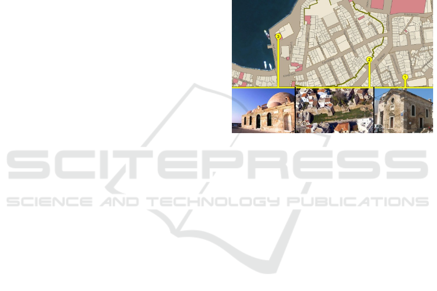
Since the Neolithic era, the city of Chania has faced
many conquerors and the influences of many
civilizations through time. Byzantine, Arabic,
Venetian and Ottoman characteristics are evident
around the cultural center of the town clustered
towards the old Venetian Harbor. In order to provide
the tourist with a view of the past, based on cutting-
edge AR technologies, we designed a historical route
throughout the city consisting of a selection of
historical buildings, to be digitally reconstructed and
presented in their past state through an AR paradigm.
The final selection includes three monuments that
represent key historical periods of the Town of
Chania (Figure 1).
The Glass Mosque is located in the Venetian
Harbor of Chania and it is the first mosque built in
Crete and the only surviving in the City dating from
the second half of the 17
th
Century. The mosque is a
jewel of Islamic art in the Renaissance and featured a
small but picturesque minaret demolished in 1920 or
in 1939. The Saint Rocco temple is a Venetian
chapelon that consists of two different forms of
vaulted roof aisles. Although the southernmost part is
preserved in good condition, the northern and oldest
one has had its exterior painted over, covering its
stony façade, while a residential structure is built on
top. The Byzantine wall was built over the old
fortifications of the Chydonia settlement around the
6
th
and 7
th
century AD. Its outline is irregular with
longitudinal axle from the East to the West, where its
two central gates were located. The wall consists of
rectilinear parts, interrupted by small oblong or
polygonal towers many of which are now partly or
completely demolished.
The scope of this work is to virtually restore
partially or fully damaged buildings and structures on
historic sites and enable visitors to see them
integrated with their real environment, while using a
sophisticated AR mobile tourist guide. We aim to
deliver geo-located information to the users as well as
calculate accurate registration positioning between
the real-world monument and 3D digitisations, while
users document their visits. By integrating digital
maps and a location-aware experience we aim to urge
the users to further investigate interest areas in the
city of Chania, Crete, and uncover their underlining
history by exploiting cutting edge AR mobile
technologies.
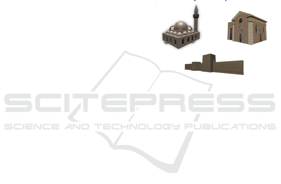
Figure 1: The Glass Mosque (left), the Saint Rocco Temple
(right), the Byzantine wall (middle).
1.2 Previous Work
AR has been utilized for a number of applications in
cultural heritage. One of the initial MAR systems
provided on-site help and AR reconstructions of the
ruins of ancient Olympia, Greece (Vlahakis et al.,
2001). The system utlilized a compass, a DGPS
receiver and combined with live view images from a
webcam, it obtained the user’s location and
orientation. Visitors carried a heavy backpack
computer and wore a see-through Head Mounted
Display (HMD) to display the digital content. The
system was a cumbersome MAR unit not acceptable
by today’s standards. MARCH (Choudary et. al.
2009) was a MAR application developed in Symbian
C++, running on a Nokia N95. The system made use
of the phone’s camera to detect images of cave
engravings and overlay them using an image
indicating ancient drawings. Although this was the
first attempt of a real time MAR application without
the use of grey-scale markers, the system still needed
the placement of coloured patches at the corners of
2D images captured in caves and the experience was
not tested in cave environments.
With the advent of mobile devices, more
sophisticated AR experiences are made possible such
GISTAM 2018 - 4th International Conference on Geographical Information Systems Theory, Applications and Management
60

as the one for the Bergen-Belsen memorial site,
(Pacheco et. al. 2014), a former WWII concentration
camp in northern Germany which was burned down
after its liberation. The application integrated
database interaction, reconstruction modelling and
content presentation in a hand held device. Real time
tracking was performed with the device’s GPS and
orientation sensors and navigation was conducted
either via map or the camera. The system was
superimposing the reconstructed building models on
the phone’s camera feed. Focusing more on the
promotion of cultural heritage in outdoor settings,
VisAge (Julier et al., 2016) was an application aiming
to turn users into authors of stories and cultural
histories in urban environments. The system featured
an online portal where users could create their stories
using routes through physical space. A story is a set
of spatially distributed POIs (Points of Interest). Each
POI has its own digital content consisting of images,
text or audio. A viewing tool was developed for
mobile tablets in Unity using Vuforia’s tracking
library to overlay the digital content in the real space.
The users could follow routes in the city and
experience new stories. Tracking was performed
using feature detection algorithms from the camera’s
feed. As per any optical approach, content delivery is
not guaranteed due to the lighting variations of the
outdoor setting.
Further work in 3D reconstructions was shown in
CityViewAR (Lee et al., 2012), a mobile outdoor AR
application that was developed to allow people to
explore destroyed buildings after the major
earthquakes in Christchurch, New Zealand. Besides
providing stories and pictures of the buildings, the
main feature of the application is the ability to
visualize 3D models of the buildings in AR, displayed
on a map. Finally, a practical solution presented in
(Hable et al., 2012) targeted guiding groups of
visitors in noisy in-door environments, based on
design decisions such as analogue audio transmission
and reliably trackable AR markers. However,
preparation of the environment with fiducials is time
consuming and the supervision of the visits by experts
is necessary to avoid accidents and interference with
the working environment.
2 METHODOLOGY
We present a MAR application that besides offering
geo-localised textual information concerning cultural
sites to a visitor, it also superimposes location-aware
3D reconstructions of historical buildings, positioned
exactly where the real-world monuments are located,
displayed on visitors’ Android mobile phone. The
geo-location approach used for real-time tracking is
based on sensors available to both high and low-end
mobile phones eliminating hardware restrictions and
allowing for easy integration of added historical
buildings. It also offers the opportunity to visualize
historical sites in non-intrusive ways without placing
markers or patches on their walls. It also introduces
gamified elements of cultural exploration.
The geo-location approach is adopted that
employs the GPS and the inertial sensors of the device
so that when the specific location of the actual
monument is registered, then the 3D reconstruction of
it would be displayed. Locations containing latitude
and longitude information are received from the GPS
while the accelerometer and geo-magnetic sensors are
used to estimate the device pose in the earth’s frame.
A visual reconstruction is then matched to the user’s
position and viewing angle displaying the overlaid
models on the mobile phone’s screen. This
implementation offers the most reliable registration
of 3D content accurately superimposed on the real-
world site, demanding less actions from the users,
therefore, ensuring a robust and intuitive experience
(Střeláket. al. 2016).
The preparation of the 3D models required the
acquisition of historical information and the accurate
depiction of them in scale with the real world. Due to
the lack of accurate plots and outlines of the
buildings, Lidar and DSM data were exported from
Open Street Maps and used to create the final models.
Designing for a mobile device means that limited
processing power and the requirements of the AR
technologies need to be taken into account. Complex
geometries can impair performance so a low-poly,
high-resolution texture approach was adopted in
order to avoid frame rate drops. The final models are
then processed through Google Sketch-up to geo-
reference and position them onto the real world while
looking at the screen of a mobile phone.
Digital maps and an AR camera displaying the
interest areas were integrated to assist in navigation
through the geo-located content. The client-server
architecture ensures that personalised experiences are
provided by storing information about user visits and
progress. Changes in the server can be conducted
without interfering with the mobile application
allowing for an easily extendable platform where new
monuments could be added as visiting areas. The
monuments’ information and assets are stored in a
database and delivered to the mobile application in a
location-request basis. The application was
developed for Android in Java as well as employing
the Wikitude Javascript API for the AR views. It
Outdoors Mobile Augmented Reality Application Visualizing 3D Reconstructed Historical Monuments
61
features a local database based on SQLite cashing the
downloaded content.
2.1 3D Modeling and Texturing
In order to record the past state of the selected
monuments, old photographs, historical information
and estimates from experts were utilized. The 3D
models visualizing their past state are presented in
real size superimposed over the real-world monument
and must be in proportion with their surroundings.
Therefore, accurate measurements of their structure
are necessary. Due to the lack of schematics and plots,
we relied on data derived from online mapping
repositories which provide outlines and height. The
outlines of the three monuments were acquired from
Open Street Map (OSM). By selecting specific areas
of the monuments on the map, we can then export an
.osm file that contains the available information
concerning that area, including building outlines and
height, where available. This file is essentially an xml
file including OSM raw data about roads, nodes, tags
etc. The file is then imported into OSM2World, e.g.,
a Java application whose aim is to produce a 3D scene
importing as input the underline data.
The modelling process was focused on preserving
a low vertex count as complex geometry
compromises interactive frame rate in systems of low
processing power such as mobile phones. Complete
3D reconstructions of the selected monuments were
created so that they completely overlap the real ones
based on AR viewing. The most important aspect of
this strategy is to keep the reconstructions in
proportion. The final scale and size are defined in
Google Sketch-up, while the final model is positioned
in the world coordinate system. The Byzantine wall
being the most abstracted, resulted in 422 vertexes.
The Glass Mosque counts 7,614 and the Saint Rocco
temple 4,919 vertexes.
Images captured from the real monuments on site
were used as references. A diverse range of materials
are assigned to different parts of the buildings. Due to
the lack of information, the actual texture of the
reconstructed parts is unknown so the aim is to more
accurately represent the compositing material rather
than the actual surface. The AR framework supports
only a power of 2 .png or .jpeg single material texture
map. That means that bumps, normal maps and multi-
textures are not included. The materials that compose
the entire texture set are baked into one image that
will serve as the final texture. UV mapping is the
process of unwrapping the 3D shape of the model into
a 2D map. This map contains the coordinates of each
vertex of the model placed on an image. Taking into
account that the monuments will be displayed on a
mobile phone screen in real size, high resolution
textures were required. This raises the final size of the
texture files, however, the process results in a high
quality visual result (2048x2048 pixels).
2.2 Geo-Positioning
In order for the reconstructions to be accurately
displayed, combined with real-time viewing of the
real world, an initial transformation and rotation is
applied. The models were exported in .dae format and
imported into Google Sketch-up.
Figure 2: Final 3D models.
The area of the monuments provided by Google
maps was projected on a ground plane. The
monument is, then, positioned on its counterpart on
the map. Given that the proportions of the monuments
are in line, the final model is scaled to fit on the
outlines. The location of the monument is then added
to the file and provided to the framework. In order
include the model in the AR framework, we export it
to .fbx and use the provided 3D encoder to make a
packaged version of the file together with the textures
in the custom wt3 format. This file is, then,
channelled to the MAR app.
3 AR SOLUTIONS
The most significant technical challenge of AR
systems is the registration issue. The virtual objects
and the real ones must be appropriately aligned in
order to maintain the illusion of integrated presence.
Registration in an AR system relies on the accurate
computation of the user’s position and pose as well as
the location of the virtual objects. Focusing on MAR
tracking is either conducted based on sensor-based
implementations or computer vision techniques.
While computer vision approaches seem to provide
pixel perfect registration, anything that compromises
the visibility between the user and the augmented area
GISTAM 2018 - 4th International Conference on Geographical Information Systems Theory, Applications and Management
62

can result in the virtual scene jitter or collapse. In
addition to this, adequate preparation of the
environment needs to take place. While sensor
approaches are more robust, limits in acquiring
reliable data leads to low accuracy. The work
proposed focuses on providing a complete MAR
experience to the end-user. Commercial AR
frameworks were employed, initially evaluating both
optical and sensor-based approaches.
3.1 Optical Implementation
In computer vision implementations, the live feed
from the camera is processed in real-time to identify
points in space, known a priori to the system and
estimate the user’s position in the AR scene. These
tracking methods require that scene images contain
natural or intentionally placed features (fiducials)
whose positions are known. Since we don’t want to
interfere with the monuments, placing fiducial
markers in the scenes was out of the question so we
relied on pictures and the natural features of the
scenes. A basic application was developed in Unity
employing the Vuforia plug-in to test the registration.
The image recognition methods use “trackable
targets” to be recognized in the real environment. The
targets are images processed through natural feature
detection algorithms to produce 2D point clouds of
the detected features to later be identified by the
mobile device in the camera’s feed. When detected,
pose and position estimations are available relative to
the surfaces they correspond to. The denser the point
clouds are, the better the estimate. This means that the
initial images need to contain a large amount of
detectable features. For real world buildings, these
features most often represent window and door
corners and intense changes in the texture, which do
not provide a large enough number of features for the
algorithm to track. Taking into account the lighting
variations of outdoors, the sets of features provided to
the system differed greatly from the actual scene and
pose tracking was not achievable. Outdoors
environments present very challenging conditions to
such implementations. Building façades provided a
limited amount of features and together with
variations in lighting conditions, such a system would
need a huge amount of images and training to reliably
track the outdoor scene. Taking also into account the
cramped environment of a touristic site, image
recognition was not a realistic choice.
3.2 Sensor Implementation
Sensor approaches use long-range sensors and
trackers that report the locations of the user and the
surrounding objects in the environment. These
tracking techniques do not require any preparations of
the environment and their implementation relies on
cheap sensors present in every modern smart phone.
They require fewer actions by the users and ensure
that the AR experience will be delivered independent
of external conditions. The AR system is aware of the
distance to the virtual objects, because that model is
built into the system. The AR system may not know
where the real objects are placed in the environment
and is relying on a “sensed” view with no feedback
on how close the two align. Specifically in MAR,
modern devices are equipped with a variety of sensors
able to provide position and pose estimations. In
outdoor settings, the Assisted GPS allows for position
tracking with an accuracy of up to 3 meters and for
pose estimation, the system combines data from the
accelerometer and geo-magnetic sensors. The
accelerometer provides the orientation relative to the
centre of the Earth and the geo-magnetic sensor to the
North. By combining this information, an estimate of
the device’s orientation in the world coordinate
system is provided. For this approach, we used the
Wikitude’s JavaScript API in combination with our
own location strategy. The Wikitude JavaScript API
was selected due to its robust results, licensing
options, big community and customer service. The
implementation includes the Android Location API
and the Google Play Services Location API. For the
later, the application creates a request, specifying
location frequency and battery consumption priority.
After it is sent out, location events are fired including
information about latitude, longitude, altitude,
accuracy and bearing. These are then provided to the
AR activities to transform and scale the
corresponding digital content on the screen.
4 SYSTEM ARCHITECTURE
4.1 Client-Server Implementation
One of the main challenges we faced in designing the
proposed MAR application was the lack of
established guidelines in the application and
integration of AR technologies in outdoor heritage
sites. The overall design of the system consists of two
main parts: the mobile client and the server. The
server facilitates a database developed in MYSQL
which holds the records about the monuments (name,
description, latitude, longitude etc.) and user specific
information. The information is delivered to the
mobile unit on a location request basis. The database
Outdoors Mobile Augmented Reality Application Visualizing 3D Reconstructed Historical Monuments
63

is exposed to the users via a Rest-full Web-Service. A
basic registration to the system is required. The
functions provided include storing data about visits,
marked places and the overall progress visualizing all
sites in a specific area.
4.2 Mobile AR Application
The mobile application’s architecture has been
designed to be extendable and respond easily to
changes in the underling model of the server. It is
based on three main layers. The Views layer is where
the interactions with the users take place. Together
with the background location service they act as the
main input points to the system. The events that take
place are forwarded to the Handling layer which
consists of two modules following the singleton
pattern. The data handler is responsible for interaction
with the local content and communicating with the
views while the Rest Client is responsible for commu-
nicating with the Web Service. The Model layer
consists of basic helper modules to parse the obtained
JSON files and interact with the local database. The
actions flow from the Views layer tothe lower
components. Responding to a user event or a location
update, a call is made to the Handling layer which will
access the model to return the requested data.
The Handling layer is the most important of the
three; all interactions, exchange of information and
synchronization passes through this layer. The Rest
Client provides an interface for receiving and sending
information to the remote database as requested by
the other layers. It is responsible for sending data
about user visits, saved places, updates in progress
and personal information. It also provides functions
for receiving data from the Server concerning Points
of Interest (POI) information and images. It also
allows for synchronizing and queuing the requests.
While the rest client is responsible for the interactions
with the server, the Data Handler is managing the
communication of the local content. Information
received are parsed and stored in the local DB. The
handler responds to events from the views and
background service and handles the business logic for
the other components. It forms and serves the
available information based on the state of the
application.
The views are basic user-interface components
facilitating the possible interactions with the users.
The Map View is a fragment containing a 2D map
developed with the Google Maps API. It displays the
user’s location, as obtained by the background
service, and the POIs as markers on the map. The AR
view is based on the Wikitude JavaScript API and is
where the AR experiences take place. It is a Web view
with a transparent background overlaid on top of a
camera surface. It displays the 3D reconstructions
while it receives location updates from the
background service and orientation updates from the
underlying sensor implementation. It also contains a
navigation view, where the POIs are displayed as
labels on the real world. Interactivity is handled in
JavaScript and it is independent from the native code.
The View pagers are framework specific UI elements
that display lists of the POIs, details for each POI,
user leader-boards and user profiles. Finally, the
Notification View is used when the application is in
the background and aims to provide control over the
location service. It is a permanent notification on the
system tray where the user can change all preferences
of the location strategy and start, stop or pause the
service at will.
The aim of the standalone background service is
to allow users roam freely in the city while receiving
notifications about nearby POIs. It is responsible for
supplying the locations obtained by the GPS to the
Map View and AR Views. The location Provider
obtains the locations and offers the option to swap
between the Google Play Services API and the
Android Location API; e.g. two location strategies. In
order to offer control over battery life and data-usage,
the users can customize its frequency settings from
the preferences. The views requesting location
updates are registered as Listeners to the Location
Service and receive locations containing latitude,
longitude, altitude, accuracy information etc. The
Location Event Controller serves the location events
to the registered views. The user’s location is
continuously compared to that of the available POIs
and if the corresponding distance is in an acceptable
range, the user can interact with the POI. The events
sent, include entering and leaving the active area of a
POI. If the application is in the background, a
notification is issued leading to the AR Views and
Map Views.
The Model layer consists of standard storing units
and handlers to enable parsing JSON files obtained
from the server and interfaces to interact with the
local DB. It stores the historical information
concerning the current local, user specific
information and additional variables needed to ensure
the optimal flow of the application. The local assets,
including the 3D models and the html, JavaScript files
required by the Wikitude API, are stored in this layer
and provided to the Handling layer as requested. The
SQLite Helper is the component responsible for
updating the local storage and offers an interface to
the Data Handler containing all available interactions.
GISTAM 2018 - 4th International Conference on Geographical Information Systems Theory, Applications and Management
64
5 MAR USER INTERFACE
The main technical challenge was to visualize, on-
site, the 3D reconstructions of monuments displayed
on a standard mobile phone, merged with the real-
world offering a location-aware experience. In this
section, we present the final user interface of the
application and the flow of the experience. Upon the
activation of the application the user is welcomed in
a splash screen and is requested to create an account
or login with an existing one. After the login process,
the application checks the location and requests the
POIs and the historical information from the server
while it transfers to the main screen. The map activity
forms the main screen of our application and
facilitates the core of the functionality as shown in
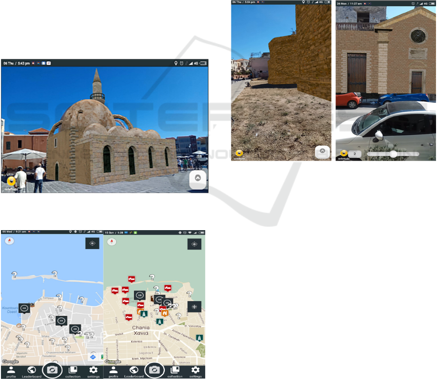
Figure 4. POIs are displayed on the map in their
corresponding geo-locations. By clicking on a
marker, the user can see the info window of the POI
containing information, a thumbnail and the distance
between POIs.
Figure 3: 3D reconstruction of the Glass mosque featuring
the now demolished minaret, as seen by MAR users.
Figure 4: Map view displaying the POIs.
By interacting with a bar at the bottom of the
screen, the user navigates the app. These include user
profile and preferences, leader-boards and the library
while a round button placed in the middle is used to
swap between map and camera navigation.
The Camera View displays the real-world content
as 2D labels, which contain basic information about
the POIs and displays them as dots on the radar to
assist in navigation. By clicking on a label, a bottom
drawer appears which holds additional information
and allows for more interactions. Users can save the
POI for later reference, access the reconstruction if
available, or return to the map. The main concept of
the experience is to reveal the available information
under controllable conditions, to facilitate a diverse
range of textual, image and 3D interactions.
Figure 5: Reconstructions of the demolished towers of the
Byzantine Wall and the restoration of the Rocco temple.
When in the initial state, the user is shown the
available 3D reconstructions on the map. After
visiting the monuments and viewing them in AR, the
rest of the POIs locations are unlocked and displayed
on the map indicated as question marks. The goal is
to visit them and classify them to the historical
periods based on their architectural characteristics
and on clues obtained in the library page and from the
already visited monuments. The exploration of the
POIs can be conducted freely by employing the
background service of the app. The users enable or
disable this functionality. The aim of this approach is
to urge the visitor to observe the monuments, consult
the information available and even interact with each
other and locals to make each decision. The more
areas they visit and unlock, the more points they earn
for themselves. The overall progress in the city can be
viewed in the Leader-boards page, accessible from
the map view.
Outdoors Mobile Augmented Reality Application Visualizing 3D Reconstructed Historical Monuments
65
The 3D reconstructions are the main feature we
aimed to provide as shown in Figures 3, 5. By
situating information in the context of their real
surroundings, we aim to elevate the communication
of cultural and historical information from static
forms to visual standards. The 3D reconstructions are
accessed from the navigation views. When the user is
in close proximity to the monuments, the location
Event Handler informs the views to update the
content and enable the AR experiences. In this screen,
a reconstructed 3D model of the monument is
overlaid on the camera and the GPS and inertial
sensors are exploited to display the monument on its
real world location. The users can freely move around
the real site to view the monuments from all available
angles. They can click on the model to get
information or access the slider, available at the
bottom right, to change between the available 3D
models. The user can shift between visualizing either
the whole model or the reconstructed parts.
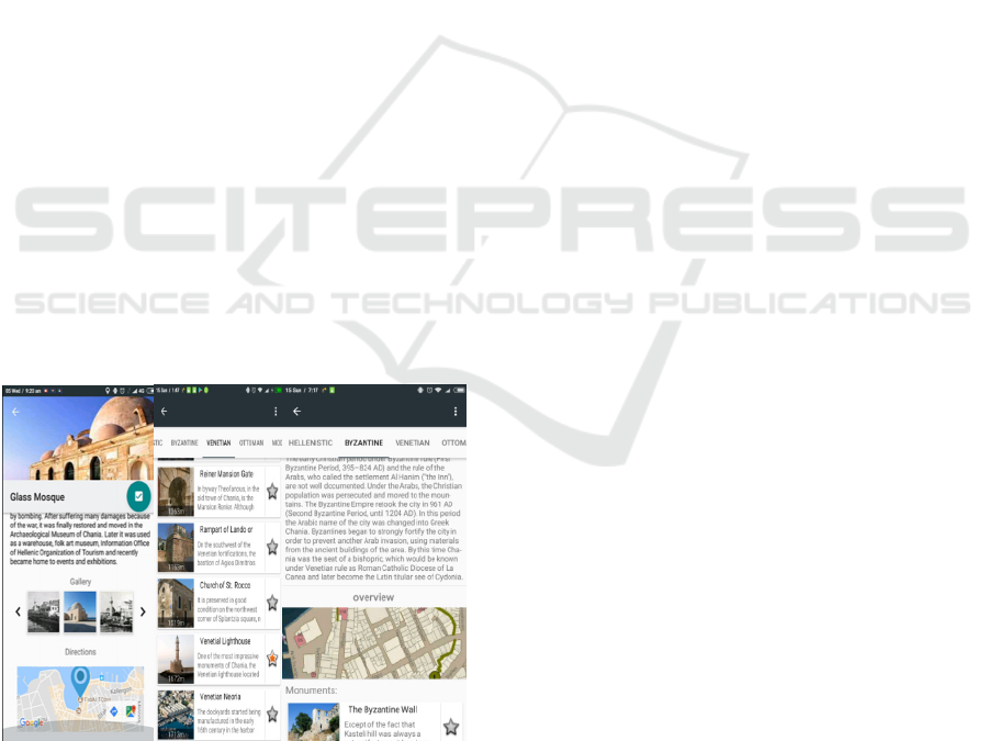
The Library page is where a collection of the
historical information is displayed (Figure 6). It
consists of a view pager containing the historical
periods in chronological order. Each page includes a
historical briefing and an image showing the active
area for that period as well as a list containing the
monuments that have been correctly classified. The
locked monuments are contained in a separate list.
The users can see the monument-specific information
by selecting the items on the list. The user can also
acquire historical information, including text and
images, mark and save monuments or get directions
to specific locations.
Figure 6: Pager View of Library, Monument details page.
6 EVALUATION
The MAR functionality as well as generic user
interface of the application was constantly evaluated
since the start of the technical development. Users
communicated comments concerning the AR camera
view during navigation stating that the use of the
camera instead of the map limited their movements
and perception of their surroundings and generally
refrained from using it except to locate specific sites
and to classify the monuments. During the
classification process, the AR camera proved useful
as it helped locate specified monuments. Moreover,
when the AR camera was on in conjunction with the
GPS, high battery consumption was an issue.
Following such comments, the AR camera was
defined as a standalone activity instead of as map
replacement.
In relation to users’ general impression using AR
experiences, user feedback was quite promising.
Most users had never been acquainted with a similar
application and were very excited to see the
reconstructions superimposed on the real-world
monument. Although the registration problem was
commented by most users, the geo-location approach
was intuitive. The instant tracking method was
overall challenging for an unaccustomed audience,
but after an initial explanation and guidance, users got
used to it and proceeded to experiment with placing
the models in the annotated area so that they are
accurately overlaid on the actual real-world building,
as viewed on the mobile phone.
7 CONCLUSIONS
We presented the design of a mobile Augmented
Reality application, geo-located and gamified, aimed
for consumer-grade mobile phones increasing the
synergy between visitors and cultural heritage sites.
In addition to exploring application screens and web
content, we offer a novel AR approach for visualizing
historical information on-site, outdoors. By offering
3D reconstructions of cultural sites through AR, we
enhance digital guide experience while the user is
visiting sites of cultural heritage and bridge the gap
between digital content and the real world. Our design
was focused on providing an expandable platform
that could envelop additional sites enabling future
experts to display their digitized collections using
cutting edge AR technologies.
Although outdoors Mobile Augmented Reality is
still hampered by technical challenges concerning
GISTAM 2018 - 4th International Conference on Geographical Information Systems Theory, Applications and Management
66

localization and registration, it offers novel
experiences to a wide audience. The availability and
technological advances of modern smart phones will
allow, without a doubt, seamless and fascinating AR
experiences enhancing the understanding of historical
sites and datasets.
The field of Augmented Reality is a quickly
evolving. Tracking and registration in AR are far
from solved. Employing a low-level AR SDK, such
as the AR-toolkit, would provide access to low level
functionality. In its current state, the application does
not support interaction between the users, apart from
the overall rankings. Extending the platform to
include comments, likes, shares etc. and adding an
additional communication layer would increase
interest in cultural heritage. Gamification combined
with scavenging and treasure hunts, location-aware
storytelling etc. would add to an even more
immersing experience and increase visitor
involvement and engagement.
REFERENCES
Azuma, R. T., Baillot, Y., Behringer, R., Feiner, S., Julier,
S., MacIntyre, B., 2001. Recent Advances in
Augmented Reality. Computer Graphics and
Applications, IEEE, 21(6):34–47.
Choudary, O., Charvillat, V., Grigoras, R., Gurdjos, P.,
2009. MARCH: Mobile AR for Cultural Heritage, In
Proc. 17th ACM Int. Conf on Multimedia, 1023-1024.
Hable, R., Rößler, T., Schuller, C., 2012. evoGuide:
Implementation of a Tour Guide Support Solution with
Multimedia and AR content. Proc. 11th Conf. on
Mobile and Ubiquitous Multimedia, No 29.
Julier, S. J., Schieck, A. F., Blume, P., Moutinho, A.,
Koutsolampros, P., Javornik, A., Rovira, A.,
Kostopoulou, E., 2016. VisAge: Augmented Reality for
Heritage. In Proc. ACM PerDis 2016, 257-258.
Kutter, O., Aichert, A., Bichlmeier, C., Traub, J., Heining,
S.M., Ockert, B., Euler E., Navab, N., 2008. Real-time
Volume Rendering for High Quality Visualization in
AR. In Proc. AMI-ARCS 2008, NY, USA.
Lee, J. Y., Lee, S. H., Park, H. M., Lee, S. K., Choi, J. S.,
Kwon, J. S.. 2010. Design and Implementation of a
Wearable AR Annotation System using Gaze
Interaction. Consumer Electronics (ICCE), 2010, 185–
186.
Nagakura, T., Sung, W., 2014. Ramalytique: Augmented
Reality in Architectural Exhibitions. In Proc. CHNT
2014.
Niedmermair, S., Ferschin, P., 2011. An AR Framework for
On-Site Visualization of Archaeological Data. In Proc.
16th Int. Conf. on Cultural Heritage and New
Technologies, 636-647.
Pacheco, D., Wierenga, S., Omedas, P., Wilbricht, S.,
Knoch, H., Paul, F. M., J., 2014. Spatializing
Experience: a Framework for the Geolocalization,
Visualization and Exploration of Historical Data using
VR/AR Tech. Proc. ACM VRIC 2014, No 1.
Ragia, L., Sarri, F., Mania, K., 2015. 3D Reconstruction
and Visualization of Alternatives for Restoration of
Historic Buildings: A New Approach. In Proc. GISTAM
2015.
Střelák, D., Škola, F., Liarokapis, F., 2016. Examining User
Experiences in a Mobile Augmented Reality Tourist
Guide, In Proc. PETRA 2016, No 19.
Vlahakis, V., Karigiannis, J., Tsotros, M., Gounaris, M.,
Almeida, L., Stricker, D., Gleue, T., Christou, I. T.,
Carlucci, R., Ioannidis, N., 2001. Archeoguide: First
Results of an AR, Mobile Computing System in
Cultural Heritage Sites. Proc. VAST 2001, 131-140,
ACM.
Zhou, F., Been-Lirn, H. D., Billinghurst, M., 2008. Trends
in Augmented Reality Tracking, Interaction and
Display: A Review of 10 Years of ISMAR. Proc.
ISMAR 2008, 193-202.
Outdoors Mobile Augmented Reality Application Visualizing 3D Reconstructed Historical Monuments
67
