
Land Use Planning in Geotourism Area: Sipiso – Piso Waterfall, Indonesia
N. Vinky Rahman
1,2
, Nurlisa Ginting
1,2
*, Nindya Narisa
1
1
Department of Architecture, Faculty of Engineering, Universitas Sumatera Utara, 9 Dr. T. Mansyur Street, Medan 20155,
Indonesia
2
Toba Lake & Sustainable Tourism Working Group, Universitas Sumatera Utara, 9 Dr. T. Mansyur Street, Medan 20155,
Indonesia
Keywords: Land Use Planning, Geotourism, Sipiso-Piso Waterfall
Abstract: Sustainable tourism has become the most popular industry for the last several years. It is not only one of the
largest source of foreign exchange income for the country, but also help to remain the sustainability in the
future. Geotourism is a part of tourism that prioritizes sustainability of the environment. Improper land use
without further planning can make a bad impact on the tourist area. Therefore, a proper plan for land use in
geotourism is very important. The purpose of this paper is to create a concept in planning the land use of
geotourism area, which is the Sipiso-Piso waterfall, to maintain the sustainability of the place, and also to
increase the quality of the tourist area. The method used in this research is a qualitative method with literature
studies beforehand, followed by interviews with related parties and field observation. After that, it would be
analyzed with elements of land use such as, land use intensity, land function, and relationship between land’s
function. The results show that the land use element in Sipiso-Piso waterfall is inadequate and needed
enchancement.
1 INTRODUCTION
Tourism is one of the industries that has largest
contribution towards the foreign exchange income for
a country (Ginting, Rahman & Nasution 2017).
Today, the concern of tourism revolves around
sustainable tourism which not only contribute
towards economic aspects for locals but also
maintains the area to be sustainable in the future
(Edgell Sr 2016). Geotourism is a part of sustainable
tourism with the concept of developing an area by
prioritizing the natural wealth namely, geodiversity
(the uniqueness of rocks). This concept is used as a
tourist attraction that educates the tourists while
prioritizing the involvement of locals and not
neglected the sustainability of the environment
(Bujdosó et al. 2015; Dowling 2013). To keep the
environment in the tourist area well maintained, a
proper planning in land use is needed. Improper or
excessive land use can cause damages towards the
tourist area (ABUHARRIS & Ruddock 2005;
Tyrväinen et al. 2014). Sipiso – Piso Waterfall is one
of the geotourism areas of the Caldera Toba, which
exists because of the eruption of largest supervolcano
in the world 74 thousand years ago (Mucek et al.
2017). Unfortunately, Sipiso-Piso does not have any
proper plan for the land use in the area. There are
always different changes made to the area annually
regarding the land use. This must be handled properly
as improper land use can lead to the damage on
sustainability of the area. Therefore, this paper
discusses how the concept of land use planning so it
will be able to maintain the sustainability of the place
and increase the quality of tourism.
2 LITERATURE REVIEW
The concept of geotourism is to develop an area
focusing on the natural wealth, namely the
geodiversity (uniqueness of the rocks) which is used
as natural tourist attraction. There are also education
for the tourists about the attraction, developed with
the participation of the locals and continue to
maintain the environmental sustainability (Bujdosó et
al. 2015; Dowling 2013). There are four elements that
should be considered in planning a geotourism area:
geological feature visiting; geo-activity like, tour
guide, cultural and educational activities; viewpoints;
facilities such as, interpretation panel, tourist
356
Rahman, N., Ginting, N. and Nar isa, N.
Land Use Planning in Geotourism Area: Sipiso – Piso Waterfall, Indonesia.
DOI: 10.5220/0010098603560362
In Proceedings of the International Conference of Science, Technology, Engineering, Environmental and Ramification Researches (ICOSTEERR 2018) - Research in Industry 4.0, pages
356-362
ISBN: 978-989-758-449-7
Copyright
c
2020 by SCITEPRESS – Science and Technology Publications, Lda. All rights reserved
information center, souvenir shop, accessibility, and
other supporting facilities (Dowling 2011; Norrish,
Sanders & Dowling 2014; Rahman et al. 2018; Štrba
et al. 2016).
Land use is a two-dimensional planning on the
functions of a place by considering the natural
capacity or the capacity of the environment.
Therefore, land use planning is a sensitive process,
where the success of physical and socio-economic
functions are depending on it (Shirvani 1985). In
making a land use plan, the intensity of land use, the
permitted function of the land, and the relationship
between existing functions must be considered. If
land use is not planned properly, there will be lost of
spaces and inappropriate distribution of land
functions (Shirvani 1985; Trancik 1986). In tourist
areas, especially in sustainable tourism, inappropriate
land use can damage the area and damage the
sustainability of the area (Berke & Conroy 2000;
Tyrväinen et al. 2014).
In this study, three elements of land use are: land
use intensity, land function, and the relationship
between the land’s functions. The three elements of
land use will be linked to the four elements of
geotourism: transportation to geological features,
viewpoints, geo-activities, facilities and
infrastructure (Table 1) with the aim of obtaining the
concept of land use planning in geotourism area.
3 METHOD
3.1 The Method
This research was done to find the land use concept
in Sipiso-Piso waterfall. The method used to collect
date is a qualitative method with observations and
interviews. Data from observation is from
photographs of the physical conditions of study area
in accordance with the research variables (Table 1).
In addition, interviews were conducted with
stakeholders related to geotourism in the study area,
namely tourism activists, government, local figures,
geologists and academic to get their perception in the
areas related to land use in geotourism area.
Furthermore, the data obtained is analyzed used the
theory of land use and geotourism to get the concept
of land use planning in the geotourism area.
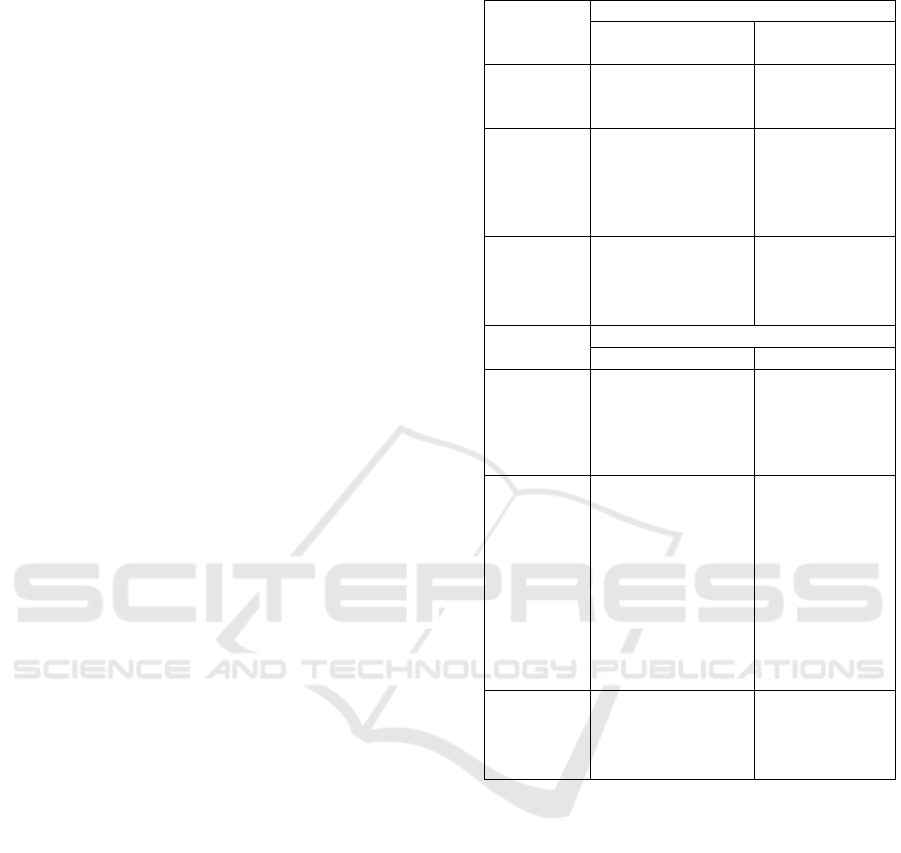
Table 1: Research Variables.
Land Use
Variables
Geotourism Variables
Geological
Features Visiting
Viewpoints
Land Use
Intensity
Land
used for
view
p
oints
Land
Function
Viewpoi
nts
Park
Stoppoi
nts
Relationsh
ip between
land’s
functions
Circulation
Land Use
Variables
Geotourism Variables
Geo-Activities Facilities
Land Use
Intensity
Land used for
geo-activities
Land used
for
infrastructur
e and
facilities
Land
Function
Restaurant
& Café
Souvenirs
Shops
Visitors
Center
Praying
Area
Toilet
Parkin
g
Relationsh
ip between
land’s
functions
Cultural Event
Educative
Attraction
3.2 Research Area
Sipiso-Piso waterfall is part of Caldera Toba with
amazing natural beauty. This waterfall was formed
from the explosion of the Toba Caldera supervolcano
which take place 74.000 years ago (Mucek et al.
2017; Rahman et al. 2018). The results of this
eruption created a panoramic view of nature, cultural
and biological diversity, and the extraordinary types
of rocks in Lake Toba area. This eruption also gave
birth to people who have local wisdom and live in
harmony with their nature (Mucek et al. 2017). Many
things can be done by visitors in there, such as
picnicking with family or just taking pictures
enjoying the natural beauty of the Waterfall. To reach
the bottom of the waterfall, visitors need a long time
Land Use Planning in Geotourism Area: Sipiso – Piso Waterfall, Indonesia
357
of about 1 hour down the stairs and to return to the
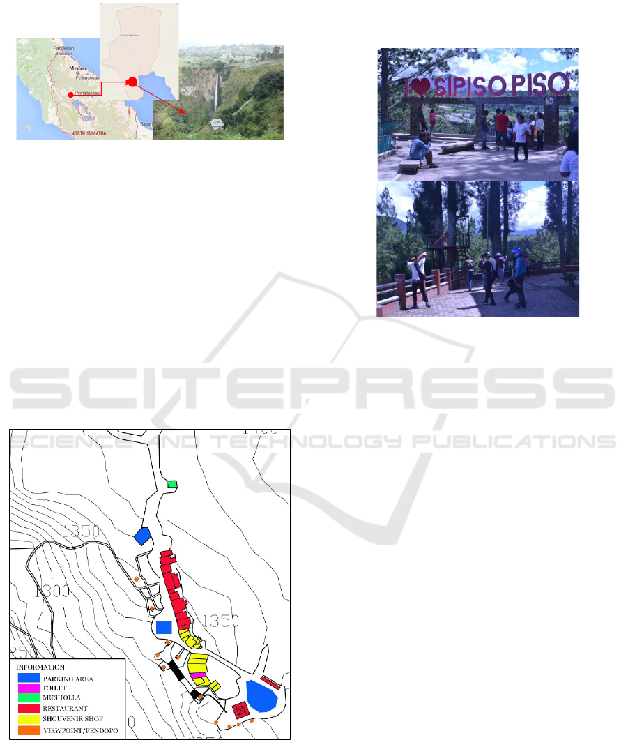
top visitors must climb the same steps (Figure 1.).
Figure 1: Sipiso – Piso, Tongging, Karo.
4 RESULT
4.1 Land Use Intensity
The open space in Sipiso-Piso Waterfall is still more
in number than the built land. The built area is mostly
in the form of food and souvenir shops, and also
toilets, mushola, and pavilions for a place to relax and
sit and see the scenery (figure 2.). it is show that
Sipiso- Piso Waterfall still has a good land use
intensity, because excessive use of land by reducing
existing open space will damage the sustainability of
an area (Berke & Conroy 2000; Downs 2005).
Figure 2: Existing Land Use.
However, most of the open space is used as
parking spaces when there were a lot of visitors. In
addition, in the past two years there has been an
unplanned viewpoint construction (figure 3). If this
condition is left unchecked, it will damage the tourist
area because excessive and unplanned land use will
make the area unsustainable(Berke & Conroy 2000;
Tyrväinen et al. 2014).
Figure 3: Unplanned Viewpoint.
4.2 Land Use Function
The land built in Sipiso-piso Waterfall has various
functions to support tourism activities there (figure
2). When viewed from the element of viewpoints,
Sipiso-piso already has several veiwpoints and a
pavillion or seating area (figure 4). But, the viewpoint
and seat were not well maintained and not well
planned. There are broken seats and some viepoints
eventually prevent visitors from seeing the views of
the Waterfall. Supposedly, the viewpoint is designed
to make tourists feel the beauty of rocks which are the
result of natural formation (ARIMA 2016). In
addition, when going down to the waterfall, there is
no adequate stoppoint place so visitors can’t rest.
Whereas the places that stopped were not planned,
some were too close, some were very far away. This
is unfortunate, stoppoints should be made so that
visitors do not feel tired and enjoy their journey
(Rahman et al. 2018).
ICOSTEERR 2018 - International Conference of Science, Technology, Engineering, Environmental and Ramification Researches
358
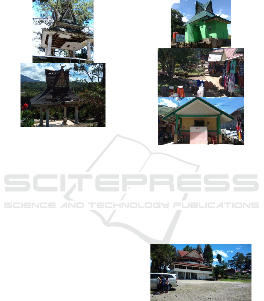
Figure 4: Seats that are not well maintained.
From the elements of facilities and infrastructure,
the land function built in Sipiso-piso Waterfall is
quite complete, there are souvenir shops, eating
places, toilets, places of worship, and parking lots
(Figure 2). Nevertheless, although it is quite
complete, the facilities are inadequate conditions,
such as souvenir shops and food places, where the
place is less representative and attractive, the existing
toilet is also poorly maintained, as well as places of
worship that although new but not maintain and have
no water (Figure 5). These facilities should be well
maintained so that visitors feel comfortable at the
tourist attractions, because a tourist place must have
good and adequate supporting facilities to support the
needs of visitors so that they are comfortable,
comfortable, and want to return to the place in the
future (Ginting & Sasmita 2018; Inskeep 1987).
Figure 5: Condition of Musholla, Souvenir Shop, and Toilet
in Sipiso-Piso Waterfall.
The parking lot at Sipiso-piso Waterfall can be
said to be quite adequate, but there is no good
planning, because if there are a lot of visitors, their
vehicles will parked along the road and open space.
Whereas there are three parking lots at there (figure
2), but the parking area are irregular, besides that the
most extensive parking lot is rarely used by visitors
(figure 6). Supposedly, th parking lot should be well
organized, because it can affect tourist satisfaction
and make them want to return to the place (Ginting,
Rahman & Nasution 2017).
Figure 6: The biggest parking lot that is not used.
Despite having quite complete facilities, Sipiso-
piso Waterfall does not have an information center
which is one of the most important places that must
be in the geotourism area. The information center can
help tourists to get information about the area of
tourist attractions that they visited, especially in the
geotourism information center can inform and offer
activities that can be done while educating tourists
Land Use Planning in Geotourism Area: Sipiso – Piso Waterfall, Indonesia
359
about what geotourism and geopark (Burlando et al.
2011; Rahman et al. 2018).
4.3 Relationship between Land’s
Functions
Between the function of one land use with the other
function is related to circulation. Therefore
circulation must be good especially in tourist areas.
Good circulation will make all the functions that exist
in an area come alive (Shirvani 1985). Unfortunately
the circulation at Sipiso-piso Waterfall has not been
well organized. There is already a special pedestrian
route, even in the viewpoint and leisure areas (figure
7) is specially passed by pedestrians only. However,
the road is damaged and has many holes. Pedestrian
paths must be well designed because tourists will tend
to walk around a tourist area if the physical path of
the pedestrian route they are going through is
comfortable and adequate (Mansouri & Ujang 2016).
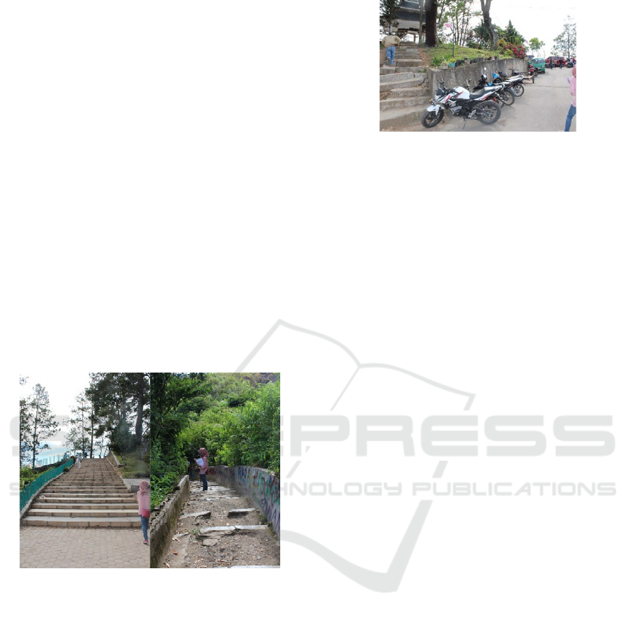
Figure 7: Condition of Pedestrian Path.
Although there are already special pathways for
pedestrians, but in some functions such as eating
places, especially mushollas that are very far
compared to other functions, there is no pedestrian
facilities. Tourists can walk along the edge of the road
and relatively safe, but if it is crowded, the roadside
is filled with vehicles such as cars and motorbikes that
require tourists to walk a little to the middle of the
road, this is very dangerous (figure 8). Supposedly,
there is a special pedestrian path that connects one
function to another, because if tourists feel that their
safety is not guaranteed they will not go to that place
(Mansouri & Ujang 2016). This will make some
function not visited by tourists.
Figure 8: Vehicles parked on the road.
Sipiso-Piso Waterfall, unfortunately does not
have a lot of activities that can be done there besides
seeing beautiful scenery while sitting or picnicking.
This is very unfortunate, because it should be as a
geotourism area, Sipiso-Piso must have many
interesting activities such as cultural activities and
education to increase the length of time they visit to
keep going (Rahman et al. 2018). Cultural activities
for example will make tourists feel the local culture
that the region has, besides that in geotourism cultural
activities can be combined with educational activities
such as in Longshuan Geopark, which provides
lessons to tourists about the natural rocks that are
there while entertaining tourists with their cultural
performance (Ginting, Rahman & Nasution 2017;
Ren, Simonson & Pan 2013).
4.4 Purpose Land Use Concept
Land use in Sipiso-piso Waterfall using the built-in
land intensity is appropriate and quite good, it's just
that there is a need improvement for unplanned
development restrictions by the local community and
misuse of open space for parking. From the elements
of land function, most of the land functions needed by
a geotourism area are there, but some important
functions such as stoppoint and information center
still do not exist. Apart from that the position and
design of the viewpoint are obstructing the view so it
must be fixed. Likewise with other functions such as
eating places, souvenir places, and toilets whose
designs are less representative. The existing parking
space is still not well organized so it must be repaired.
For the relationship between function one and other
functions, there is still no good circulation and easy
for tourists to pass through and there are still no
interesting activities to be done by tourists there.
Therefore, the land use planning at Sipiso-Piso
Waterfall is need to improved to overcome these
problems (Figure 9).
ICOSTEERR 2018 - International Conference of Science, Technology, Engineering, Environmental and Ramification Researches
360
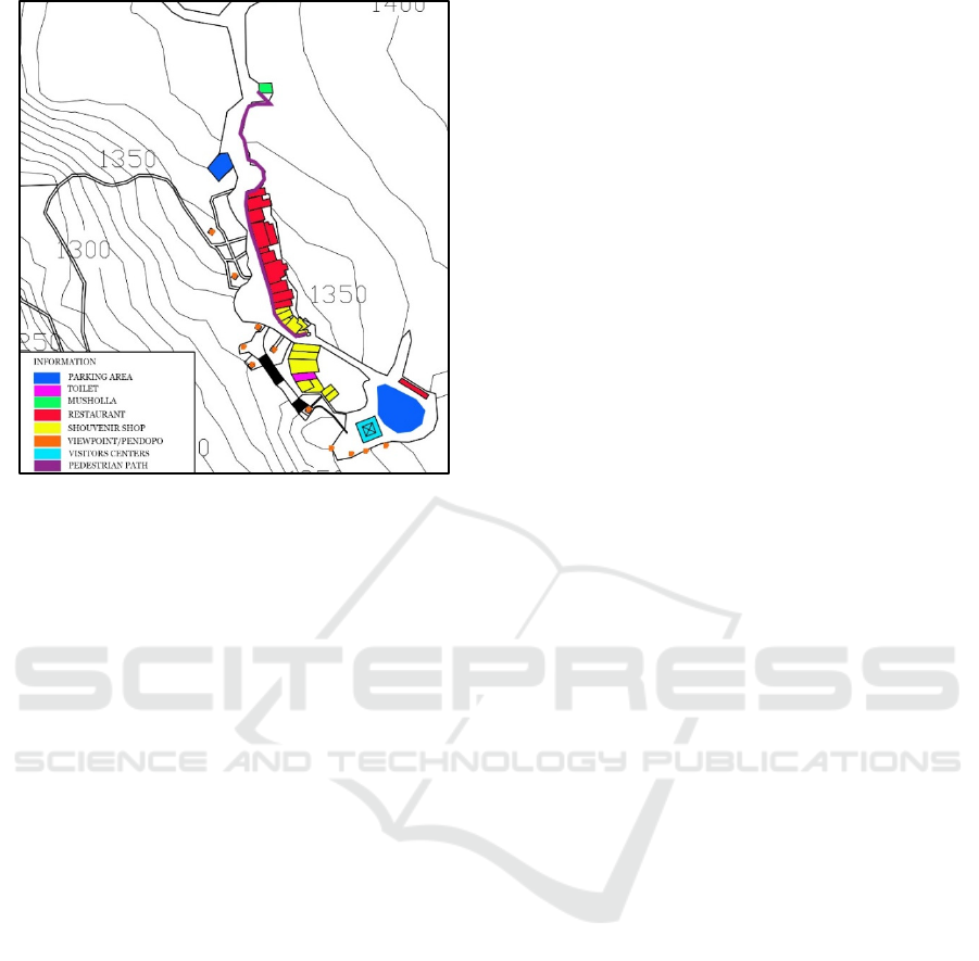
Figure 9: Purpose Land Use.
Changes that made are not many, as for the first
change is to make an information center at Sipiso-
Piso Waterfall. The information center will used one
of the biggest building in Sipiso-piso that used to be
dining place only. This is very unfortunate because
the largest building there is only used for eating
places that also do not use the entire building. So,
instead of create new building, the information center
used that building instead.
The second change is to reduce the parking space
in Sipiso-Piso Waterfall, precisely the parking lot in
the middle of the area. This change was made, in
addition because the parking lot was very obstructing
the beautiful scenery that can be obtained from the
middle of the area so that the largest parking space
can be used by visitors so that there are no more
jostling vehicles in the middle of the Sipiso-Piso
Waterfall area. In addition, the central part will be
used as an open space to conduct various geotourism
activities such as cultural activities.
Other changes are the addition of stoppoints and
pedestrian paths around the dining area to the
musholla. This addition is done so that tourists when
visiting can feel comfortable. The addition of
stoppoint will reduce visitors' fatigue when climb
down to the location of the waterfall. Then the
pedestrian path along the dining area to the musholla
will give tourists a sense of security when walking
without fear of a vehicle.
5 CONCLUSIONS
Sipiso-Piso Waterfall, seen from the land use is
already good enough. The three elements of land use,
namely land use intensity, land function, and
relationships between functions are quite good.
However, even so there are still some deficiencies in
these three elements. In the element of land use
intensity because there is no land use plan, there are
some unplanned viewpoint developments. In the
element of land function, there is still an important
function in the geotourism area which is not owned
by Sipiso-Piso Waterfall, namely Stoppoint and
information centers and irregular parking spaces. In
the element of relationship between functions,
circulation for pedestrian pathways is still not good
and adequate. Therefore, this paper provides the
concept of land use planning to address these
problems. Unfortunately, not all problems can be
solved by conceptualizing land use planning, such as
the problem of less representative building design and
less geotourism activities that cannot be resolved with
land use planning. Therefore, the author recommends
a study of other planning elements in the Sipiso-Piso
Waterfall geotourism area.
ACKNOWLEDGEMENTS
This research is financing supported by DRPM
Ministry of Research and Technology and the Higher
Education Republic of Indonesia with the research
grant of number 155/UN5.2.3.1/PPM/KP-
DRPM/2018 Year 2018. And in the field this research
is also supported by Toba Lake & Sustainable
Tourism Working Group Universitas Sumatera Utara.
REFERENCES
ABUHARRIS, M.R.A.T. & Ruddock, L. 2005, ‘Land-use
planning and sustainable tourism development in
Libya’, June 13th to the 15th of 2008 Athens, Greece,
vol. 97.
ARIMA, T. 2016, ‘Overview: The educational capabilities
of geoparks: From education to learning’, Journal of
Geography (Chigaku Zasshi), vol. 125, no. 6, pp. 775–
8.
Berke, P.R. & Conroy, M.M. 2000, ‘Are we planning for
sustainable development? An evaluation of 30
comprehensive plans’, Journal of the American
planning association, vol. 66, no. 1, pp. 21–33.
Bujdosó, Z., Dávid, L., Wéber, Z. & Tenk, A. 2015,
‘Utilization of geoheritage in tourism development’,
Procedia-Social and Behavioral Sciences, vol. 188, pp.
Land Use Planning in Geotourism Area: Sipiso – Piso Waterfall, Indonesia
361

316–24.
Burlando, M., Firpo, M., Queirolo, C., Rovere, A. &
Vacchi, M. 2011, ‘From geoheritage to sustainable
development: strategies and perspectives in the Beigua
Geopark (Italy)’, Geoheritage, vol. 3, no. 2, pp. 63–72.
Dowling, R.K. 2011, ‘Geotourism’s global growth’,
Geoheritage, vol. 3, no. 1, pp. 1–13.
Dowling, R.K. 2013, ‘Global geotourism--an emerging
form of sustainable tourism’, Czech Journal of
Tourism, vol. 2, no. 2, pp. 59–79.
Downs, A. 2005, ‘Smart growth: Why we discuss it more
than we do it’, Journal of the American Planning
Association, vol. 71, no. 4, pp. 367–78.
Edgell Sr, D.L. 2016, Managing sustainable tourism: A
legacy for the future, Routledge.
Ginting, N., Rahman, N.V. & Nasution, A.D. 2017,
‘Increasing tourism in Karo District, Indonesia based
on place identity’, Environment-Behaviour
Proceedings Journal, vol. 2, no. 5, pp. 177–84.
Ginting, N. & Sasmita, A. 2018, ‘Developing tourism
facilities based on geotourism in Silalahi Village,
Geopark Toba Caldera’, IOP Conference Series: Earth
and Environmental Science, vol. 126.
Inskeep, E. 1987, ‘Environmental planning for tourism’,
Annals of Tourism Research, vol. 14, no. 1, pp. 118–35.
Mansouri, M. & Ujang, N. 2016, ‘Tourist’expectation and
satisfaction towards pedestrian networks in the
historical district of Kuala Lumpur, Malaysia’, Asian
Geographer, vol. 33, no. 1, pp. 35–55.
Mucek, A.E., Danišík, M., De Silva, S.L., Schmitt, A.K.,
Pratomo, I. & Coble, M.A. 2017, ‘Post-supereruption
recovery at Toba Caldera’, Nature Communications,
vol. 8, p. 15248.
Norrish, L., Sanders, D. & Dowling, R. 2014, ‘Geotourism
product development and stakeholder perceptions: a
case study of a proposed geotrail in Perth, Western
Australia’, Journal of Ecotourism, vol. 13, no. 1, pp.
52–63.
Rahman, N.V., Ginting, N., Narisa, N. & others 2018,
‘Planning a tourism landscape in geosite area: Sipiso-
piso waterfall’, IOP Conference Series: Earth and
Environmental Science, vol. 126, p. 12196.
Ren, F., Simonson, L. & Pan, Z. 2013, ‘Interpretation of
geoheritage for geotourism--a comparison of Chinese
geoparks and national parks in the United States’,
Czech Journal of Tourism, vol. 2, no. 2, pp. 105–25.
Shirvani, H. 1985, The urban design process, Van Nostrand
Reinhold Company.
Štrba, L., Kršák, B., Molokáč, M. & Adamkovič, J. 2016,
‘Geotourism and geoparks—a sustainable form of
environmental protection’, Production Management
and Engineering Sciences, vol. 279, ROUTLEDGE in
association with GSE Research, pp. 279–84.
Trancik, R. 1986, Finding lost space: theories of urban
design, John Wiley & Sons.
Tyrväinen, L., Uusitalo, M., Silvennoinen, H. & Hasu, E.
2014, ‘Towards sustainable growth in nature-based
tourism destinations: Clients’ views of land use options
in Finnish Lapland’, Landscape and Urban Planning,
vol. 122, pp. 1–15.
ICOSTEERR 2018 - International Conference of Science, Technology, Engineering, Environmental and Ramification Researches
362
