
The Global Maritime Nexus: Challenges in Managing Marine Area in
North Sumatera Province
Suhaidi
1
, Rosmalinda
1
and Riadhi Alhayyan
1
1
Faculty of Law, Universitas Sumatera Utara, Jl. Universitas No 4 Kampus USU, Medan, Indonesia
Keywords: Global maritime nexus, readiness, local government, North Sumatera Province.
Abstract: Global maritime nexus is a strategic idea. Indonesia should realize it in order to ensure the community
welfare. This study figures out the answer of study in 8 months in North Sumatera province. This study
focuses on the readiness of North Sumatera government in realizing Indonesia as a global maritime nexus in
Malacca Strait. One strategy to achieve the vision is regulated it in the regional spatial management.
Through in depth interviews and Focus Group Discussion (FGD) which conducted to collect information
related to preparedness in policy and challenges of local government in marine management found that the
provincial government has local regulation No. 2 of 2017 concerning the regional spatial plan of North
Sumatera province (RTRWP) in 2017-2037 which in line with the 2nd and 3rd pillars of the global maritime
nexus. The presence of the new RTRWP needs to be socialized in order to disseminate the idea of Indonesia
global maritime nexus. It is not only a strategic issue but also an idea which can be applied in the program
of local government organizations (OPD) which located contiguous to the sea such as North Sumatera
province.
1 INTRODUCTION
Article 25 A of Indonesian Constitution 1945
amendment 4 states that the united country of
Republic of Indonesia is an archipelagic country
which is characteristic of the archipelago with its
territory and boundaries and rights established by
law (UUD 1945). Indonesia is the largest
archipelagic country in the world which has the
potential to become the global maritime nexus. This
is in accordance with Law Number 32 of 2014
section 5 (1) which stated, "Indonesia is an
archipelagic country composed entirely of islands
and covers large and small islands constituting a
unified territory, political, economic, social cultural,
and historical areas whose territorial boundaries are
drawn from the archipelagic base" (UU No 32,
2014).
The potential to become the maritime nexus of
the world has been conveyed by the President of the
Republic of Indonesia at the East Asia summit, in
2015. He mentioned five pillars that make Indonesia
the Global maritime nexus; (1) Rebuilding
Indonesia's maritime culture; (2) Commitment to
maintain and manage marine resources by focusing
on building sea food sovereignty through the
development of the fishing industry by placing
fishermen as the main pillars; (3) commitment to
encourage the development of maritime
infrastructure and connectivity by building sea tolls,
seaports, logistics and shipping industries, as well as
maritime tourism; (4) maritime diplomacy that
invites all Indonesian partners to cooperate in the
maritime sector is the fourth pillar of the
development agenda; (5) Finally, as a country that is
the nexus of two oceans, Indonesia is obliged to
build maritime defense forces (Pidato Presiden RI-
KTT 9 Asia Timur, 2014).
One of the provinces in Indonesia is North
Sumatera. This province has become strategic in
realizing the idea of a maritime nexus delivered by
the president of Indonesia. First, the province of
North Sumatera consists of 33 districts/cities, to the
east is directly adjacent to the Malacca Strait (BPS,
2017). Second, the province of North Sumatera has a
coastline of 1,300 Km, of which 545 km is the
length of the East Coast Line. Both of these
conditions place Noth Sumatera as a province that
contributes greatly to the realization of Indonesia as
the global maritime nexus. Furthermore, the central
government and regional governments in addition to
ensuring the achievement of the implementation of
Suhaidi, ., Rosmalinda, . and Alhayyan, R.
The Global Maritime Nexus: Challenges in Managing Marine Area in North Sumatera Province.
DOI: 10.5220/0010094016631669
In Proceedings of the International Conference of Science, Technology, Engineering, Environmental and Ramification Researches (ICOSTEERR 2018) - Research in Industry 4.0, pages
1663-1669
ISBN: 978-989-758-449-7
Copyright
c
2020 by SCITEPRESS – Science and Technology Publications, Lda. All r ights reserved
1663

Indonesia's idea as a global maritime nexus should
also ensure protection and management of the sea,
especially the marine environment of the East Coast
of North Sumatera.
Indonesia as a maritime country needs to realize
the importance of the function of protection and
preservation. This must be realized in order to
maintain dependence on natural resources in the sea
in quantities and quality that meet the requirements
and are available in a sustainable manner. Especially
if referring to the extent of Indonesian waters
covering an area of 6,166,163 km
2
. The Indonesian
sea which contents natural resources will add to land
capacity, both biological and non-living.
Unfortunately Indonesia still does not ratify or
legalize laws and regulations that prevent and
protect its waters from all types of ship
transportation pollution (Suhaidi, 2017). Therefore,
the second pillar of the world's maritime nexus
strategy is important because he mentioned the
commitment to maintain and manage marine
resources by focusing on building sea food
sovereignty through the development of the fishing
industry by placing fishermen as the main pillars.
The above situations and conditions are
opportunities for the Government of North Sumatera
Province. It's time for the North Sumatera provincial
government to prepare to realize strategic ideas
about Indonesia as the global maritime nexus. This
is important because opportunities can turn out to be
a threat when the central and regional governments,
especially North Sumatera province, do not have
readiness. These preparations include preparation of
policies such as spatial and regional policies and
management of the marine environment.
This study focuses on the readiness of North
Sumatera provincial government in the field of
marine environment in facing the global maritime
nexus. Specifically the location discussed in this
study is the east coast of North Sumatera province,
the Malacca Strait. Two questions are asked to find
out what preparations have been made by the North
Sumatera provincial government, namely; what
policies have the North Sumatera provincial
government to realize Indonesia as global maritime
nexus? And what is the North Sumatera Provincial
Government Challenge in preparation of Malacca
Strait management related to Indonesian as global
maritime nexus?.
2 RESEARCH METHODOLOGY
This research was conducted by literature review
and field. Literature study is carried out by
collecting, reading and analyzing legal rules, books
and information sources in the form of print or
electronic. Field studies are carried out by collecting
information through in-depth interviews and focus
group discussions (FGD) involving staff or leaders
of the agency
3 RESULT AND DISCUSSION
Indonesia is a maritime country. This statement is
true and may be believed by every Indonesian
citizen. A childhood experience of my sailor's
ancestors could be a reinforcement of that belief.
The desire to reinforce that Indonesia is a leading
maritime country during the current administration
(Shanti, 2015). This hope certainly requires
Indonesia to be able to utilize all the marine
elements around it for the welfare of the people and
the progress of the nation. Some writings state that
the desire to become a maritime country is actually
inseparable from the desire to immediately achieve
prosperity and prosperity in Indonesia (Shanti,
2015). Shanti Darmastuti and Emmy Farida Subekti,
for example, wrote in the challenges of Indonesian
maritime diplomacy towards the global maritime
nexus that Indonesia would achieve prosperity and
prosperity through economic development of the
maritime domain (Shanti, 2015).
Furthermore, Latifah & Dinda Larasati wrote in
internal challenges in realizing Indonesia as the
global maritime nexus that the strategic idea of
Indonesia as global maritime nexus has a positive
impact on improving Indonesia's economy in the
future. Thee paper stated that the position of
Indonesia as an international trade cross into a great
economic resource if utilized to the maximum
through the global maritime nexus. It was further
stated that the president of the Republic of Indonesia
was targeting the successful global maritime nexus,
the progress of the lower middle-level countries with
a per capita income of US $ 3,592 in 2015 towards
the upper middle income countries with a per capita
income of US $ 10,000 in 2045. In other words, if
the policy of the global maritime nexus is achieved
as expected then Indonesia can be sovereign in terms
of the economy (Latifah, 2017).
Both of these writings show that the hope of
making Indonesia a global maritime nexus is a hope
for the prosperity of the Indonesian people
especially in the economy. This paper will then see
ICOSTEERR 2018 - International Conference of Science, Technology, Engineering, Environmental and Ramification Researches
1664

whether these expectations can materialize in North
Sumatera's east coast stretching along 545 km of
beach. Not only the beach but also the location of
the rivers of the rivers of the Bukit Barisan mountain
range with a relatively high level of population
density compared to other regions. Conditions of
marine waters in coastal areas are muddy and
dominance of mangrove forests.
3.1 North Sumatera Provincial
Government Policy to Realize
Indonesia as Global Maritime
Nexus
This section must be in one column Law No. 17 of
2007 on the National Development Plan of 2005-
2025 mentions the appendix on the Vision and
Mission of the National Development Of 2005-2025.
The vision of Indonesia's development is Mandiri
(independent), Maju (forward), Adil (equal) and
Makmur (prosperity). The seventh mission of the
2005-2025 national development is "Creating
Indonesia as an independent, advanced, strong,
nation-based Islands Country" (UU No 17, 2007).
The meaning of this mission is to foster marine-
oriented development for the community and
government, and to increase the comprehensive and
sustainable use of human resources, national marine
areas and marine technology for the sovereignty and
welfare of the Indonesian.
Potential marine resources need to be managed
optimally and sustainably in order to realize the
ideals of Indonesia as a Global maritime nexus and
in an effort to provide maximum benefits for the
welfare of the people. Based on that, on February
20, 2017, the President of RI has signed Perpres No.
16 of 2017 on Indonesian Marine Policy. This
Indonesian Ocean Policy is a general guideline of
marine policy and implementation steps through
programs and activities of ministries / institutions in
the field of maritime that are prepared in order to
accelerate the implementation of the Global
maritime nexus.
Thus, Law No. 17/2007 (National RPJP 2005-
2025) and Indonesian Maritime Policy have
provided direction for maritime and maritime
development covering aspects that are very relevant
to the Preamble of the Preamble to the 1945
Constitution. This policy and law has also identified
crucial issues in the effort to utilize and management
of marine resources, thereby encouraging policy
makers to harmonize and synchronize regulations
leading to the unification of maritime law and
national maritime which is now fragmented
partially.
One Act that is also important to note is Law No.
23 of 2014 concerning local government. This law
provides an explanation of the distribution of marine
affairs and fisheries affairs at the central, provincial
and district / city governments.
Table 1: Affairs of maritime affairs and fisheries at
the provincial government according to Law No. 23
of 2014 on Regional Government
.
No Sub affairs Province government
1 Marine, Coastal;
and Small Islands
a. Management of
marine space up to
12 miles outside oil
and gas
b. Issuance of sea
space permits and
utilization under 12
miles outside oil and
gas
c. Empowerment of
coastal communities
and small islands
2 Fishing a. Fish management
and marine areas up
to 12 miles
b. The issuance of
fishing fisheries
business licenses for
fishing vessels
measuring above 5
GT to 30 GT
c. Determination of
development sites
and management of
provincial fishing
ports
d. Issuance and fishing
vessel with a size
above 5 GT up to 30
GT
3 Cultural Fisheries Issuance of IUP in the
field of fish cultivation
whose business is
crossed by regency / city
in 1 (one) Province
4 Supervision of
Marine and
Fisheries
Resources
Supervision of marine
and fisheries resources
up to 12 miles
5 Management and
Marketing
Issuance of marketing
business licenses and
management of fishery
products across
regencies / cities in 1
(one) Province
These national regulations have become the basis
for the North Sumatera provincial government to
ratify the North Sumatera Provincial Regulation No.
The Global Maritime Nexus: Challenges in Managing Marine Area in North Sumatera Province
1665

2 of 2017 on Spatial Plans of North Sumatera
Province in 2017-2037. This law provides a
definition of the Provincial Spatial Plan (RTRWP)
as a general spatial plan of the province, which is an
elaboration of the RTRWN, which contains
provincial spatial objectives, policies, spatial
planning strategies; provincial spatial structure plan;
provincial spatial pattern plan; determination of
provincial strategic areas; direction of spatial use of
provincial area; and the direction of controlling the
utilization of provincial space.
It seems that RTRWP is a technical plan of the
National Development Plan (RPN), therefore if the
RPN states that the seventh mission of the 2005-
2025 national development is "Creating Indonesia as
an independent, advanced, strong and nation-based
Islands Country based on national interest "(UU No
17, 2007) then RTRWP has similar development
planning.
Article 4 of the Regional Regulation of RTRWP
The scope of the planning area covers all areas of
North Sumatera Province with an overall area of
approximately 183,449.17 km2 (one hundred eighty
three thousand four hundred and forty-nine point
seventeen square kilometers) which includes: (a)
72,325.47 km2 (seventy two thousand three hundred
twenty five point forty seven square kilometers); (b)
an ocean of approximately 110,000 km2 (one
hundred and ten thousand square kilometers); and
(c) water bodies of Lake Toba covering an area of
approximately 1,123.70 km2 (one thousand one
hundred and twenty three point seventy square
kilometers). Furthermore, RTRWP also made
several articles that regulate the steps that must be
done by the North Sumatera provincial government
related to the five pillars to make Indonesia the
World Maritime Shaft. Specifically, the RTRWP is
in line with two commitments, namely commitment
2, namely the commitment to maintain and manage
marine resources by focusing on building sea food
sovereignty through the development of the fishing
industry by placing fishermen as the main pillar and
commitment 3, namely the commitment to
encourage the development of infrastructure and
maritime connectivity by building sea tolls, seaports,
logistics, and shipping industries, as well as
maritime tourism.
Table 2: Article North Sumatera Provincial Regulation
No. 2 of 2017 on Spatial Planning of North Sumatera
Province 2017-2037 which is in line with the pillar of
making Indonesia the global maritime nexus.
Pillars
make
Indonesia
a global
maritime
Article of Provincial Regulation of North
Sumatera No. 2 of 2017 concerning
Spatial Planning for North Sumatera
Province in 2017-2037
nexus
commitme
nt 2 is the
commitme
nt to
maintain
and
manage
marine
resources
with a
focus on
building
sovereignt
y of sea
food
through
the
developm
ent of
fishery
industry
by placing
fishermen
as the
main
pillar
Article
27
Paragraph (6) mentions the
existence of aquaculture area
covering the area of fisheries
and marine allotment
Article
39
Plan for the Development of
Fishery and Marine
Utilization Area; Paragraph
(1) The spatial pattern of the
fishery and marine
designation area includes the
area of aquaculture, capture
fisheries and processing of
fishery products; Paragraph
(2) Development of marine
aquaculture and capture
fisheries areas and public
waters, covering all regencies
/ cities; Paragraph (3)
Development of fishery
product processing areas is in
fisheries producing centers;
Paragraph (4) Development
of fishery allotment areas is
carried out in areas that have
potential and are suitable for
the development of fisheries
and marine, among others:
(a). development of
agromarinpolitan area
covering coastal area; west,
east coast, and Nias Islands;
(b). development of
minapolitan areas, covering
the west coast, the east coast,
and the Nias Islands; (c).
development of fish seed
center spread throughout the
province of North Sumatera;
(d). fish landing bases (PPI)
to support capture fisheries
activities spread across the
East Coast and West Coast of
North Sumatera as listed in
Annex XXVII are an integral
part of this regional
regulation; (e). development
of Fishery Seaport (PPP) in
West Coast, East Coast and
Nias Islands; (f). construction
of an integrated cold storage
warehouse to support
national fish logistics systems
in fish production and
distribution centers and
fishery products, including
Medan City, Sibolga City,
Tanjungbalai City, Batubara
Regency, Deli Serdang
Regency, Central Tapanuli
ICOSTEERR 2018 - International Conference of Science, Technology, Engineering, Environmental and Ramification Researches
1666
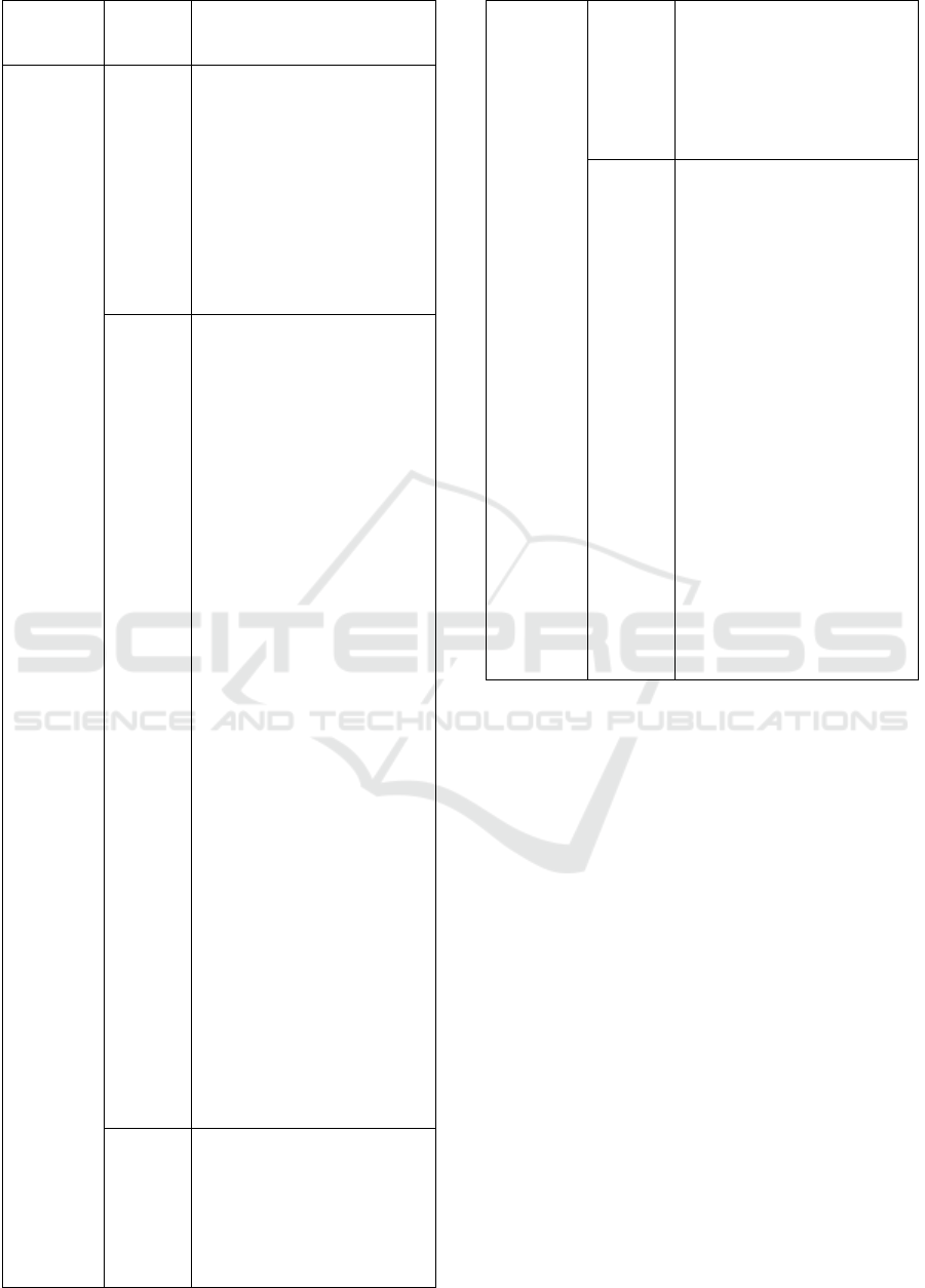
Regency, Mandailing
Regency Christmas, and the
Nias Islands
commitme
nt 3 is a
commitme
nt to
encourage
the
developm
ent of
maritime
infrastruct
ure and
connectivi
ty by
building
sea tolls,
seaports,
logistics
and
shipping
industries,
as well as
maritime
tourism
Article
8
Transportation network
system includes marine
transportation network
system covering (a) port
order; and (b) cruise line.
This transportation network
system plan aims to optimize
and
development of
transportation network
structures
Article
11
Development of a
network of rivers, lakes and
crossings
includes increasing and
developing transport service
networks
rivers, lakes and crossings
(ASDP) include (a) nodes of
river, lake and crossing
networks including seaports
that are used to serve
crossing transportation, (b)
cross-border crossing
transportation service
networks, namely
Medan-Penang (Malaysia),
Medan-Kuala Lumpur
(Malaysia), Medan-
Singapore, Tanjungbalai-
Singapore and Tanjungbalai-
Malaysia; and (c). cross-
province crossing transport
service network, namely
Medan-Batam, Medan-
Lhokseumawe, Medan-
Pangkal Pinang,
Gunungsitoli-Singkil, Telo-
Teluk Bayur Island; and (d) a
network of transportation
services for rivers, lakes and
crossings
regencies / cities namely
Sibolga - Gunungsitoli,
Sibolga - Teluk Dalam,
Teluk Dalam - Telo Island,
Natal - Telo Island,
Article
13
Paragraph (1)
Development of the port
structure is a sea port
including: (a) main port; (b).
collecting ports; (c). feeder
port, which consists of: 1)
regional feeder port; and 2)
the local feeder port.
Paragraph (2) The
arrangement of the shipping
channel includes (a). general
shipping lines and crossings;
and (b) port of shipping
passage.
Article
14
Paragraph (1)
Development of the existing
port order within the
province; paragraph (2)
Development of sea transport
along the east coast of North
Sumatera by water bus.
Paragraph (3) Development
of ports along the east coast
of North Sumatera to support
sea transport along the east
coast of North Sumatera.
Paragraph (4) Development
of ports to encourage
economic growth of the
region on the west coast of
North Sumatera. (5) The
development of Kuala
Tanjung Port is designated as
an international hub port at
the western gate of Indonesia
in the order of the National
Logistics System.
It is seen that the RTRWP which is the basis for
its preparation refers to Law Number 17 of 2007
concerning the National Development Plan for 2005
- 2025 has adjusted to the provisions of Law No. 23
of 2014 concerning local government and the idea of
the president of the Republic of Indonesia 2014-
2019.
3.2 Challenge of North Sumatera
Provincial Government in
Preparation of Marine
Management Related to Indonesian
Maritime Nexus
The challenge according to the Indonesian Big
Dictionary (KBBI) Online means things or objects
that inspire determination to improve problem-
solving skills; stimulus (to work harder and so on).
The difficulty of doing things is a challenge to work
harder as well as the readiness of the North
Sumatera provincial government. The study, entitled
"The Readiness of Medan City Government
(Malacca Strait) In Facing China Maritime Silk
Road and Maritime Shaft of the World" finds some
The Global Maritime Nexus: Challenges in Managing Marine Area in North Sumatera Province
1667

of the challenges faced by North Sumatera
provincial government.
First, lack of popularity of the term maritime
nexus among the local governement institutions. The
reason raised by informants when conducting focus
group discussions is the limited description of the
main tasks and functions stipulated in the governor's
2016 regulation.
“...the language of the maritime nexus has not been
used by the provincial government, while the
readiness is already there, culinary readiness,
tourism, and others. The maritime nexus, now there
are also plans for the opening of the field from the
silangit to guang zhou, even the North Sumatera
provides support facilities, with the support also
from the center. The sea why there is no cruise ship
as one of the potential, collect data of potential areas
then looks for opportunities to be marketed to
investors...” (FGD on 5 July 2018)
In addition, the arrangement related to the idea of
Indonesia as a maritime nexus is still at the central
level as one of the informants found during the in-
depth interview.
“..already, there is already, in the sea
transportation department on the fifteenth floor,
medan merdeka barat...” (Joko,L, 2018)
Secondly, the new regional regulation on
RTRWP in North Sumatera is North Sumatera
Province Regulation No. 2 of 2017 on Spatial Plan
of North Sumatera Province 2017-2037.
“...the maritime nexus has been heard. Local
regulation spatial, there are still some District /City
there are still unfinished RTRW it, and submitted to
bappeda to be hastened ... Bylaws RTRW cannot
cover sea affairs because the sea has its own zone.
And we cannot map it ourselves, and are being made
about marine RTRW / marine zone, tourism
industry, sand, etc. ... once gave permission about
sand dredging and marine minister angry because
there is no national regulation related to the division
of marine zone. Marine zones and others will be
covered, both fisheries, cultivation, including the
disposal of marine waste, there must be a marine
spatial regulation...” (FGD on 5 July 2018)
Both of the above research findings are the
challenges that become the homework of the North
Sumatera provincial government. The strategic idea
of Indonesia being the global maritime nexus can
only be realized if every region such as the northern
sumatera province along the 1,300 km coastline, of
which 545 km is the length of the East Coast Line is
willing to work together with the central
government. Another important thing is the position
of the east coast of northern Sumatra bordering the
Malacca Strait should be maintained and managed
the marine environment well. If not, then major
losses can occur for the next generation.
4 CONCLUSIONS
Conclusions and recommendations of this research
are two things, first, the North Sumatera provincial
government has a policy related to the strategic idea
of Indonesia as a maritime nexus namely North
Sumatera Province Regulation No. 2 of 2017 on
Spatial Plan of North Sumatera Province 2017-2037.
Unfortunately, this regulation only end of 2017 is
present so it still needs socialization RTRW North
Sumatera Province 2017-2034 not only to local
governments but also development partners and the
community. So that the hope of Indonesia as a
maritime nexus of the world through the protection
and management of the sea on the east coast of
North Sumatera facing the Malacca Strait can be
realized.
The steps taken by the North Sumatera Provincial
Government in the preparation of the management
of the Malacca Strait associated with the Indonesian
maritime nexus find the challenge of (s) the
unfamiliarity of maritime shaft terms in government
including the unused use of the term in the local
regulatory documents, and (b) about marine spatial
planning. Based on these challenges, local
governments can coordinate intensively with the
central government in terms of marine protection
and management on the east coast of Sumatera.
ACKNOWLEDGEMENTS
We would like to thank the Research and Service
Institute of Universitas Sumatera Utara who
supported the authors to implement research
program through TALENTA research scheme of
Fiscal Year 2018 based on the Rector Letter
Number: 433 / UN5.1.R / SK / PPM / 2018.
REFERENCES
Undang-Undang Dasar Negara Republik Indonesia Tahun
1945.
Undang-Undang Nomor 32 Tahun 2014 tentang Kelautan.
Pidato Presiden RI Joko Widodo Pada KTT ke-9 Asia
Timur, di Nay Pyi Taw, Myanmar, 13 November
2014, accessed on 27
th
July 2018
<http://setkab.go.id/pidato-presiden-ri-joko-widodo-
ICOSTEERR 2018 - International Conference of Science, Technology, Engineering, Environmental and Ramification Researches
1668

pada-ktt-ke-9-asia-timur-di-nay-pyi-taw-myanmar-13-
november-2014/>
Badan Pusat Statistik provinsi North Sumatera, Provinsi
North Sumatera dalam angka 2017, BPS.
Shanti Darmastuti dan Emmy Farida Subekti, Tantangan
Diplomasi Maritim Indonesia Menuju Poros Maritim
Dunia’, Proseding UPN "VETERAN" JAKARTA,
accessed on 25
th
July 2018
<http://library.upnvj.ac.id/pdf/artikel/prosiding/prosidi
ng_upnvj/pp-fh-upn-17-sep-2015/17-%2032.pdf>
Suhaidi, ‘A proposed “special area” to protect the marine
environment from the ships pollution in Indonesia’. J.
Bio. Env. Sci. 11(5), 124-130, November 2017,
accessed on 20 July 2018
<http://www.innspub.net/jbes/proposed-special-area-
protect-marine-environment-ships-pollution-
indonesia/>
Latifah & Dinda Larasati, ‘Tantangan Internal dalam
Mewujudkan Indonesia Sebagai Poros Maritim
Dunia’, Jurnal Hubungan Internasional, Tahun X,
No.2, Juli - Desember 2017
Undang-Undang Nomor 17 Tahun 2007 tentang Rencana
Pembangunan Jangka Panjang Nasional Tahun 2005-
2025
Peraturan Daerah Provinsi Sumatera Utara No. 2 tahun
2017 tentang Rencana Tata Ruang dan Wilayah
Provinsi Sumatera Utara Tahun 2017-2037
Focus Group Discussion on 5 July 2018
Joko, L, 2018, Secretary of Pelindo 1, Resource Person,
interview on 20 June.
The Global Maritime Nexus: Challenges in Managing Marine Area in North Sumatera Province
1669
