
Steps Towards Simulating Smart Cities and Smart Islands with a Shared
Generic Framework
A Case Study of London and Reunion Island
Tahina Ralitera
1
, Maxime Ferard
2
, Gonzalo Bustos-Turu
2
, Koen H. Van Dam
2
and R
´
emy Courdier
1
1
Laboratoire d’Informatique et de Math
´
ematiques (LIM), University of Reunion Island,
Parc Technologique Universitaire, Saint-Denis, France
2
Department of Chemical Engineering, Imperial College London, South Kensington, London, U.K.
Keywords:
Agent based Simulation, Smart Island, Smart City, Model Re-use, Replication, Software Refinement.
Abstract:
Simulation models can be used as decision support tools for smart city design and planning. They allow to
evaluate the possible consequences of projects, before their implementation in the real world. Decision makers
could benefit from replicable ones that can be relevant and easily transferable from one territory to another so
solutions can be compared and re-use of model components can save time. In this paper we consider the case
of citizen’s mobility flow simulation. However, most of such simulation models are designed to be suitable
for a specific kind of territory. Some of them are reusable, but in a context that does not differ much from
the original one for which they were designed, or require lots of changes to be relevant in another context.
We classify those contexts into urban and insular and we show that despite their difference, they could be
complementary. We demonstrate that testing a simulation model designed for an urban context, in a context
with strong constraints can help in its consolidation. Thereby, after testing an Agent Based Simulation Model
originally applied to a case study in London, in Reunion Island, we present a more generic simulation model
that works for both systems.
1 INTRODUCTION
Currently, combining competitiveness and sustain-
able urban development in cities becomes a challenge.
Consequently, government, citizens and stakeholders
have to search for technical solutions to reduce eco-
nomic and environmental crises that come with the
growth of urbanization. On the other hand, since these
last decades, the development of ICTs has contributed
to great changes in cities in all points of view (eco-
nomic, cultural, transport...). Those trends have led
to the growing popularity of the concept of ”smart
city” (Dijkstra et al., 2013), defined by (Longo et al.,
2014) as a ”place and territorial context, where use of
planned and wise of the human and natural resources,
properly managed and integrated through the various
ICT technologies already available, allows for the cre-
ation of an ecosystem that can be used of resources
and to provide integrated and more intelligent sys-
tems”.
A city system is considered as a complex system
(Batty et al., 2012) characterised by:
• Micro-interactions of both human-human and
human-environment;
• Emergence of unexpected phenomena that arise
from the behaviour of independent units;
• Non-linear dynamics i.e. it is difficult to predict
the output of the system from its inputs;
• Feedback loops.
It is composed of different recognizable subsets, in-
cluding individuals with various behaviours, who are
no more considered only as users of the system, but as
part of it. Proposed smart city solutions should there-
fore consider those characteristics and should be able
to adapt to the individuals and to the environment in
which they are. Agent-Based Modelling is a promis-
ing solution in developing such a complex system. It
allows to break down city into smaller simpler subsets
handled by several autonomous, social, reactive and
proactive entities. An approach that allows to model
non-linearity and favors the emergence of necessary
standards and protocols needed for the Smart Cities
(Roscia et al., 2013).
Ralitera, T., Ferard, M., Bustos-Turu, G., Dam, K. and Courdier, R.
Steps Towards Simulating Smart Cities and Smart Islands with a Shared Generic Framework - A Case Study of London and Reunion Island.
DOI: 10.5220/0006371203290336
In Proceedings of the 6th International Conference on Smart Cities and Green ICT Systems (SMARTGREENS 2017), pages 329-336
ISBN: 978-989-758-241-7
Copyright © 2017 by SCITEPRESS – Science and Technology Publications, Lda. All rights reserved
329

Different projects are done and simulation models
are often used by policy makers to evaluate their pos-
sible consequences before their application in the real
world. It would be therefore interesting to have repli-
cable simulation models that could be easily trans-
ferable from one context to another. However, cur-
rently, many of them are designed for a specific en-
vironment and are only transferable to a context that
do not differ much from the original one. Making
experimentations in insular territory such as islands
could be interesting for the consolidation of a simu-
lation model designed for urban territories, as islands
might be considered as an ideal candidate for tests un-
der real-life conditions before later implementation in
urban areas. In this paper, the SmartCityModel, an
agent based simulation model, originally applied to a
context of urban systems such as London, is tested.
Insights gained from applying this model to Reunion
Island help develop this framework further to be more
widely usable in different contexts and thereby con-
tributes to a generic simulation model presented here.
This paper is structured as follows, section 2 gives
an overview of smart cities, smart islands and agent
based simulations of mobility flow as stated in the
literature. Section 3 is about a comparative study
between urban and island systems and section 4 de-
scribes the experimentations. Finally, Section 5 re-
flects the approach and discusses the contributions.
2 RELATED WORK
2.1 Smart Cities and Smart Islands
The ”smart city” is considered as a solution that could
solve the problems linked to the growth of the urban-
ization and the increase of the environmental and eco-
nomic crises in the city. Currently, there is still no uni-
versal definition, but (Longo et al., 2014) define it as
a ”place and territorial context, where use of planned
and wise of the human and natural resources, prop-
erly managed and integrated through the various ICT
technologies already available, allows for the creation
of an ecosystem that can be used of resources and to
provide integrated and more intelligent systems”. A
smart city is well performed in 6 key fields (Giffin-
ger, 2011), related to some urban life aspects (Albino
et al., 2015): smart economy, smart mobility, smart
environment, smart people, smart living, smart gover-
nance. The experimentation described in this paper is
focused on the smart mobility part of this smart city,
but could also be applied to the other parts.
Islands are also facing the same problems as cities,
to which additional constraints are added. Indeed, due
to their remoteness, their isolation and other specific
geographical constraints, islands are facing multiple
challenges in managing energy, resources, transport...
Those lead to think about ”smart islands”. Currently,
to our knowledge, the concept of smart city is sub-
ject to lots of study, however few works are talking
about smart islands. And most of the time, the given
solutions suit to a particular territory (Choo, 1997)
(Gioda, 2015). Sometimes, however, it is interest-
ing to have a re-usable simulation model that could
be easily transferable from one territory to another, by
taking into account characteristics which are proper to
different types of territories such as cities and islands
(Comparison will be discussed later, at Section 3).
2.2 Agent based Simulation Models
Different approaches were used in the literature for
simulating transport mobility: trip-based approach,
tour-based approach and activity-based approach.
The proposed simulation model uses activity-based
approach which supposes that travel derived from
the demand for personal activities (work, shopping,
leisure...) that individuals need or wish to perform
(McNally and Rindt, 2007). In the example, the
SmartCityModel (Bustos-Turu et al., 2014) (see Sec-
tion 4.1) is used to simulate the electric transport and
the impact of that on the electricity consumption, de-
pending on agents activity schedule. Similar works
can be found in the literature (Sweda and Klabjan,
2011) but none take into account the specific con-
straints that could be very important for some kind of
territory such as oceanic islands. For example, they
do not consider the geographical parameters such as
road slopes (Maia et al., 2011). Also, transport be-
haviour considerations such as vehicle speed or the
use of comfort items, that could also influence the
energy consumption (Bingham et al., 2012) (Karaba-
soglu and Michalek, 2013), are usually neglected. So,
such simulation models may not be transferable in
the context of a territory where these missing param-
eters could strongly influence the electric vehicle’s
consumption. Consequently, testing such simulation
models in a very different context, such as an oceanic
island one, could help to improve their generic nature
by detecting such missing parameters. It is also inter-
esting to explore how these features could be added to
an existing approach.
To support these proposals, a comparative study
between urban and insular context is done in the next
section, followed by experimentations on the particu-
lar case of London and Reunion Island.
SMARTGREENS 2017 - 6th International Conference on Smart Cities and Green ICT Systems
330

3 COMPARATIVE STUDY
3.1 Urban and Insular Systems
An urban area generally contains one or several of
the following features: local municipality, large pop-
ulation, high population density, and economic ac-
tivity which does not mainly depend on primary re-
sources exploitation (Unicef et al., 2012). However, it
is strictly defined at a national level, but there is no in-
ternational agreement on this topic. This raises impor-
tant issues in the comparison of urban zones located in
different countries, as diverging city definitions might
create misleading results. It must also be noticed that
the administrative definitions of cities boundaries are
not covering the entire real city. However, the major
part of the data are from the local government, and are
therefore based on that definitions. As a result, using
another boundary would strongly increase the com-
plexity of the research, both in terms of geographic
limits setting and data collection.
Many simulation models are tested only on ur-
ban systems (Badariotti and Weber, 2002) (Sweda and
Klabjan, 2011) (
ˇ
Certick
`
y et al., 2015), so there could
be a problem in translating them in systems with dif-
ferent geographical and socio-cultural characteristics
such as insular systems.
Insularity refers to areas with more or less marked
spatial boundaries that identify, at least in theory, a
set of elements from diverse origin, participating in
the same territorial dynamics. It is therefore favor-
able to the study of the functioning and the viabil-
ity of systems, and the islands are interesting exam-
ples (Magnan, 2009). Indeed, islands are pieces of
lands surrounded by water and which are above wa-
ter at high tide (Nations, 1994). Their boundaries are
already set by geographic constraints and are time-
independent. Moreover, unless they have a direct link
with the mainland (e.g. electrical network, bridge),
every flows that come from and to the islands are eas-
ily traceable as they occur by plane or boat. The usual
classification of islands is also relatively clear (ocean
and continental) and independent of the local govern-
ment. Apart from these facts, islands can be home to
different cities and towns. In this respect, the previ-
ous considerations about urban system characterisa-
tion are also valid for islands having high population
levels and urban centres.
3.2 Comparison
When comparing them, island and urban systems
present very different structural features. Because of
their relative differences, the two systems could re-
act in very different ways to the same changes. Ta-
ble 1 summarizes the comparison of the two systems.
Indeed, urban areas are hard to define and to break
down into elementary units, whereas islands have
fixed boundaries and a more common structure due
to their geographical characteristics. From a system
perspective, islands appear to be easier to define and
study. They might be considered as an ideal candidate
for tests under real-life conditions before later imple-
mentation in urban areas. However, despite their dif-
ferences, islands and cities could be complementary.
Therefore, making experiments on both cities and is-
lands can generate useful insights for the discussion
of transferability of smart city solutions from islands
to cities.
4 CASE STUDY
4.1 The Simulation Model
Proposed simulation SmartCityModel is built upon
the free and open source Agent-Based Modelling and
Simulation platform Repast Simphony (North et al.,
2013). It was used for different case study around
urban systems, such as for simulating the interac-
tions between land use, transport and electric ve-
hicle charging demand (Bustos-Turu et al., 2015),
residential electricity and heat demand (Bustos-Turu
et al., 2016), estimating plug-in electric vehicle de-
mand flexibility (Bustos-Turu et al., 2014) or for mod-
elling water and sanitation infrastructure use in urban
systems (The Ecological Sequestration Trust (TEST),
2016).
In this paper, the application area is electric trans-
port and the example simulate Plug-in Electric Ve-
hicle (PEV) flow in the city. PEV owners are mod-
elled as agents who take travel and charging decisions
based on their perceptions and memories. They use
an activity schedule and are capable to adapt their be-
haviour given a particular situation such as a reduc-
tion in the charging tariff. The environment, in which
they are situated and act, is represented by a collec-
tion of objects, each representing a fragment of the
modelled physical reality. It is defined using a GIS
representation (shape files).
To summarise, the simulation model takes, as in-
put, GIS and statistical data. As output, it generates
metrics such as electricity consumption and charging
station usage profiles, which are stored in .csv files.
Those .csv files could be used for further studies, us-
ing post-processing software. Figure 1 shows the ini-
tial experiment process of the simulation model.
Steps Towards Simulating Smart Cities and Smart Islands with a Shared Generic Framework - A Case Study of London and Reunion Island
331
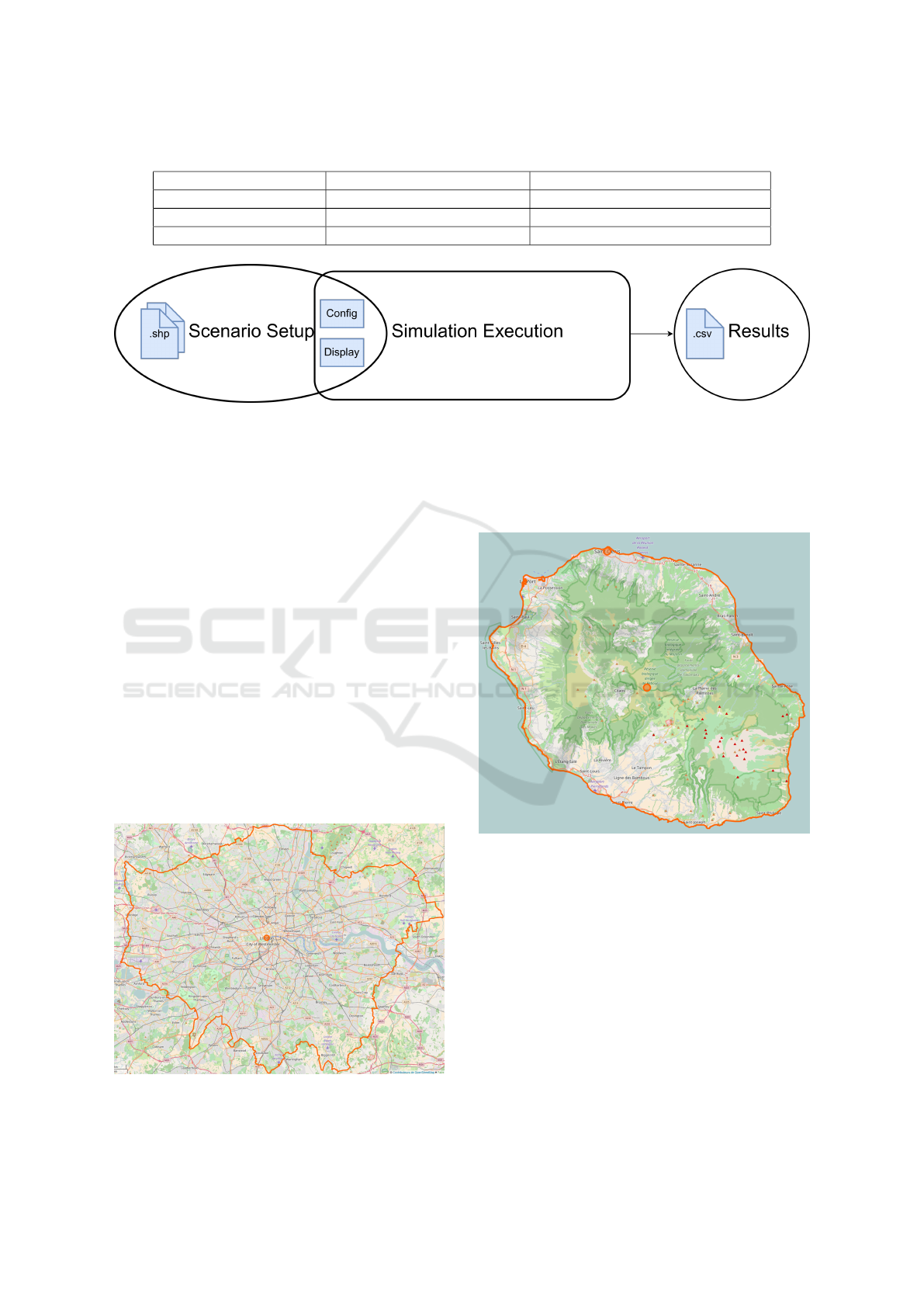
Table 1: Key structural differences between islands and cities.
Islands Cities
Physical boundaries Set by geography, Constant Many possibilities, Time-dependant
Geographical constraints Often strong in oceanic island Often small or null
In/out flows Easy to evaluate Hard to determine
Figure 1: SmartCityModel initial experiment process.
Experiments are carried out in London and Re-
union Island, in 2 steps: a comparative analysis be-
tween the 2 contexts and experiments by simulation.
The approach adopted follow the three steps exper-
iment process used in (
ˇ
Certick
`
y et al., 2015): ex-
perimentation specification (scenario definition and
setup), simulation execution, result analysis and vi-
sualisation. This allows not only to make adjustments
in the parameterization of the simulation, but also to
take into account all the aspects going from the initial-
ization to the interpretation of the results. Aspects that
seem important to consider because they are all linked
and contribute to the generic nature and the relevance
of the simulation model.
4.2 London and Reunion Island
London (Figure 2) is the capital of the United King-
dom. It is an urban area of 1,572 km
2
, populated by
8,538,700 inhabitants (in 2014). Situated in the north
hemisphere, it has a temperate oceanic climate.
Figure 2: London map.
Reunion Island (Figure 3) is a French island sit-
uated in the south hemisphere, in the Indian Ocean,
nearby Madagascar and Mauritius. It is an oceanic
island of 2,512 km
2
, with a tropical climate and pop-
ulated by 843,529 inhabitants (in 2015).
Figure 3: Reunion Island map.
First of all, as opposed to London, which has mov-
ing boundaries, Reunion Island has boundaries that
are delimited by the sea. Moreover, it is a completely
remote island and in and out flows are easier to de-
fine. The center of the island is a national park, with
a very high elevation, so population housing and mo-
bility are constrained by the physical characteristics.
Moreover, Reunion Island has a contrasted relief, with
an altitude variation from 0 to 3070.50 m (the Piton
des Neiges), while in London the slope is negligi-
ble. Consequently, if in London, the population and
their mobility are scattered across the territory, in Re-
union Island, they are concentrated in the coastal ar-
eas. Second, due to their different geographical posi-
SMARTGREENS 2017 - 6th International Conference on Smart Cities and Green ICT Systems
332

tion, their environment, their relief and their climate
are also different. The average temperature in London
is 12.4
◦
C against 27.7
◦
C in Reunion Island. However,
in Reunion Island the temperature can be lower in
the mountainous areas and higher in the coastal areas.
The average precipitation is also higher in Reunion is-
land: around 10 000 mm per year against 622.5 mm.
Therefore, the use of comfort items in vehicles such
as air conditioning, heating, wipers, etc. is not the
same. Finally, compared to its small size, London is
10 times more populated than Reunion Island.
To sum up, to be transferable to a context sim-
ilar to Reunion Island, the simulation model should
take into account the parameters listed in table 2 (non-
exhaustive list).
Table 2: Non-exhaustive list of parameters.
Classification Examples
Geographical Slope
Socio-cultural
Population density and
geographical distribution, speed
Climate related
Use of comfort items,
temperature variation
4.3 Experimentations
In this experimentation, the SmartCityModel is used
to implement a Reunion Island case, what entails
changes in the maps, the statistical data used and the
agent behaviour (mobility concentrated in the coastal
roads for example).
4.4 First Improvements
First experimentations on Reunion Island revealed
some limitations. Limitations that could also appear
in other simulation models and in similar territories
(oceanic islands or territories with high geographical
constraints). The experimentations follows the three
steps cited in section 4.2. The results and the dis-
covered limitations and problems are summarised in
Table 3. Improvements are done following the same
3 previous levels:
4.4.1 Initialisation of the Simulation
The initialization process of the simulation model is
reorganized, based on works done by (
ˇ
Certick
`
y et al.,
2015). Now, a .csv file is used to define the sce-
nario parameters and the display is set up automati-
cally. Consequently, the user will no longer have to
change the source code of the program or the display,
manually. Moreover, wrong file, variable formats and
missing attributes, are checked at this level, in order
to avoid errors that could appear during the simulation
run.
4.4.2 Simulation Core
Improvements can be classified in 2 categories:
First, there are improvements in the algorithm. In
fact, to address the problem of unrealistic geographi-
cal population distribution (see Table 3), a buffer zone
is added around the road network. It allows to gener-
ate agents location and activities areas nearby roads.
Therefore, population distribution is more realistic:
concentrated in the coastal areas and the few people
who are in the center of the island live nearby roads.
The following pseudo-code show how the buffer zone
is used to generate a random location nearby a road:
set BUFFER_DISTANCE to buffer radius
Initialise nearestRoad to null
while nearestRoad==null do
set coords = random coordinate inside
a building
set nearestRoad = the road where the
distance from coords is equal
to BUFFER_DISTANCE
end do
return coords;
Then, an alternative method that consists of defin-
ing the activity area locations from shape files (one
shape file for an activity zone) is created to address
the problem of missing land use distribution data used
for the generation of the activity areas location. Gen-
erated locations correspond to the precise location of
the activity zones in the real world. However, we kept
both methods. The method used is chosen automati-
cally at the initialisation of the simulation, according
to available data.
Second, there are improvements in the simulation
setting. It is about the implementation of the param-
eters listed in Table 2. Parameters that, according to
studies described in Section 4.2 could influence the
relevance of the simulation results. This part is still in
progress, but currently the speed variation is already
taken into account in the simulation. For that, a new
attribute is added to the road shape files. This new at-
tribute takes the value of ”majorRoad” if the road is
a major road. Then a speed advantage is assigned for
car drivers when driving on a major road.
4.4.3 Visualisation of the Simulation Results
It is interesting to link the simulation platform with
post-processing tools in order to have an automated
treatment as well as a more adequate visual exploita-
tion of simulation results. (Augusseau et al., 2013)
Steps Towards Simulating Smart Cities and Smart Islands with a Shared Generic Framework - A Case Study of London and Reunion Island
333
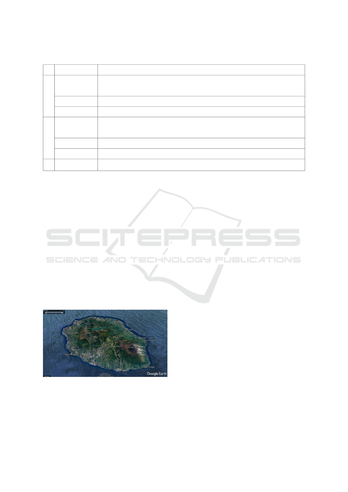
Table 3: Experimentations on Reunion Island.
Step Details Limitations
Simulation initialisation
File processing
Shape files have to be contained in a specific folder, if not, need to change the path in the source code
Shape files content are not checked so that induce errors during the simulation execution
Display configuration Manual
Scenarios definition Need to set global variables value in the source code
Simulation core
Population distribution
Unrealistic population distribution
Large number of agents are located in the center of the island which in reality is a very sparsely populated area
Data availability Some important data are not available. For example: land use distribution (percentage of the different activity zones per commune)
Simulation configuration Geographical, socio-cultural and other parameters not taken into account (slope, speed, etc.)
Results
A post-processing step must be done for analysis and visualization, using different tools
and (
ˇ
Certick
`
y et al., 2015) show that having a spa-
tialized display of the simulation metrics in an earth
browser such as Google Earth can be interesting. It
gives the possibility to replay a previous simulation
run, particularly useful for validation by domain ex-
perts. Indeed, recording a model as a video preserves
the movement, but removes inspection capabilities.
Moreover, it is then difficult to include the animation
in web applications and to layer it with other spatial
data sets. To address this, an export mechanism which
records the simulation and its metrics and exports it
to KML format is developped. It allow to incorporate
data in displays using an interactive geobrowser. This
export function can be used to create a web interface
showing the output of a simulation run and the varia-
tion in the time of the metrics across different parts of
the simulated area. An example of display is shown
on figure 4.
Figure 4: An example of results display on Google Earth.
4.5 Results
Figure 5 shows the new process of the SmartCity-
Model. The 3 parts (scenario definition, simulation
execution, result analysis and visualisation) are sepa-
rated into 3 connected blocks. This new organization
make the initialisation of the simulation and the sce-
nario definition simpler, so the user do not need to be
familiar with Repast Simphony. Changing the simu-
lated territory is easier as the user only have to add
the shape files and the display is configured automat-
ically. Moreover, results visualization is better and
there is an automatic first results post processing.
5 DISCUSSION AND FUTURE
WORKS
The paper present experimentations done on an Agent
Based Simulation model originally applied to a case
study in urban systems, on strong constraints systems
such as insular systems. By taking a model previously
used in a London case study and applying it to Re-
union Island by a new team of modellers, some limi-
tations were detected and improvements are done on
3 levels:
• The scenario definition and setup;
• The simulation execution;
• The result analysis and visualisation.
They show that making such experimentations could
generate useful insight that can help at improving the
transferability of such simulation models from one
context to another. Most of the functionality imple-
mented are generic enough to be easily transferable
to other contexts. However, there are still some fur-
ther improvements and verifications that should be
done to validate the simulation model, in particular,
SMARTGREENS 2017 - 6th International Conference on Smart Cities and Green ICT Systems
334

Figure 5: SmartCityModel 3 steps process, after improvements.
in the simulation core by implementing missing es-
sential geographical and socio-cultural parameters.
One of the most important is the slope. Indeed,
currently, in the SmartCityModel, the agent route
is chosen following the shortest path algorithm, a
method that could be improved by adding more cri-
teria for the choice of the road. For example, for
energy saving and vehicle power reason, an agent
could choose a road with less slope even if it is longer
in distance instead a short one but with high slope.
This could produce the emergence of a collective phe-
nomenon that lead to the concentration of the traffic in
coastal roads, where slopes are lower. A phenomenon
that corresponds to the reality in the Island. More-
over, it has also impact on efficiency, especially with
EV used as case. As we need to know how much en-
ergy is used, maybe it is beneficial to charge at the top
of the mountain than at the bottom. And it is applica-
ble not only for islands case but also for cities with big
hills or even mountains such as Rio de Janeiro of Lis-
bon where these improvements following the islands
application will be relevant.
So, the future work will be first of all focused on
the implementation of those geographical and socio-
cultural parameters. Then, we can proceed to vali-
dation by experimentations on other urban and island
systems. Finally, verification of the simulation results
could be done by domain experts.
REFERENCES
Albino, V., Berardi, U., and Dangelico, R. M. (2015). Smart
cities: Definitions, dimensions, performance, and ini-
tiatives. Journal of Urban Technology, 22(1):3–21.
Augusseau, X., Aulanier, F., Begue, A., Bourgoin, J.,
David, D., David, G., Degenne, P., Fargette, M.,
Lagabrielle, E., Lajoie, G., Laurent, J.-B., Lebour-
geois, V., Lestrelin, G., Lo Seen, D., Loireau, M.,
Tillard, E., Todoroff, P., Tonneau, J.-P., and Vitry,
F. (2013). Simulation cartographique au service
de l’innovation collective. In SAGEO’2013, Brest,
France. 16 p.
Badariotti, D. and Weber, C. (2002). La mobilit
´
e
r
´
esidentielle en ville. mod
´
elisation par automates cel-
lulaires et syst
`
eme multi-agents
`
a bogota. Lespace
g
´
eographique, 31(2):97–108.
Batty, M., Axhausen, K. W., Giannotti, F., Pozdnoukhov,
A., Bazzani, A., Wachowicz, M., Ouzounis, G.,
and Portugali, Y. (2012). Smart cities of the fu-
ture. The European Physical Journal Special Topics,
214(1):481–518.
Bingham, C., Walsh, C., and Carroll, S. (2012). Impact of
driving characteristics on electric vehicle energy con-
sumption and range. Intelligent Transport Systems,
IET, 6(1):29–35.
Bustos-Turu, G., Van Dam, K., Acha, S., and Shah, N.
(2015). Integrated planning of distribution networks:
interactions between land use, transport and electric
vehicle charging demand. In 23rd International Con-
ference on Electricity Distribution, Lyon, France.
Bustos-Turu, G., van Dam, K. H., Acha, S., Markides,
C. N., and Shah, N. (2016). Simulating residential
electricity and heat demand in urban areas using an
agent-based modelling approach. In Energy Con-
ference (ENERGYCON), 2016 IEEE International,
pages 1–6. IEEE.
Bustos-Turu, G., van Dam, K. H., Acha, S., and Shah, N.
(2014). Estimating plug-in electric vehicle demand
flexibility through an agent-based simulation model.
In Innovative Smart Grid Technologies Conference
Europe (ISGT-Europe), 2014 IEEE PES, pages 1–6.
IEEE.
ˇ
Certick
`
y, M., Jakob, M., and P
´
ıbil, R. (2015). Analyzing
on-demand mobility services by agent-based simula-
tion. Journal of Ubiquitous Systems & Pervasive Net-
works, 6(1):17–26.
Choo, C. W. (1997). It2000: Singapore’s vision of an in-
telligent island. In Droege, P., editor, Intelligent Envi-
ronments, pages 49 – 65. North-Holland, Amsterdam.
Dijkstra, L., Garcilazo, E., and McCann, P. (2013). The
economic performance of european cities and city re-
gions: Myths and realities. European Planning Stud-
ies, 21(3):334–354.
Giffinger, R. (2011). European smart cities: the need for
a place related understanding. Department of Spatial
Development, Infrastructure and Environmental Plan-
ning of Vienna university of Technology.
Gioda, A. (2015). El hierro (canaries): une
ˆ
ıle et le choix
Steps Towards Simulating Smart Cities and Smart Islands with a Shared Generic Framework - A Case Study of London and Reunion Island
335

des transitions
´
energ
´
etique et
´
ecologique. VertigO-
la revue
´
electronique en sciences de l’environnement,
14(3).
Karabasoglu, O. and Michalek, J. (2013). Influence of driv-
ing patterns on life cycle cost and emissions of hybrid
and plug-in electric vehicle powertrains. Energy Pol-
icy, 60:445–461.
Longo, M., Roscia, M., and Lazaroiu, G. C. (2014). Inno-
vating multi-agent systems applied to smart city. Re-
search Journal of Applied Sciences, Engineering and
Technology, 7(20):4296–4302.
Magnan, A. (2009). Syst
`
emes insulaires, repr
´
esentations
pyramidales et soutenabilit
´
e: approche comparative
oc
´
ean indien/petites antilles. Les Cahiers dOutre-Mer.
Revue de g
´
eographie de Bordeaux, 62(248):529–548.
Maia, R., Silva, M., Ara
´
ujo, R., and Nunes, U. (2011). Elec-
tric vehicle simulator for energy consumption studies
in electric mobility systems. In Integrated and Sus-
tainable Transportation System (FISTS), 2011 IEEE
Forum on, pages 227–232. IEEE.
McNally, M. G. and Rindt, C. R. (2007). The activity-based
approach. In Handbook of Transport Modelling, pages
55–73. Emerald.
Nations, U. (1994). United nations convention on the law
of the sea. Technical report.
North, M. J., Collier, N. T., Ozik, J., Tatara, E. R., Macal,
C. M., Bragen, M., and Sydelko, P. (2013). Com-
plex adaptive systems modeling with repast simphony.
Complex adaptive systems modeling, 1(1):3.
Roscia, M., Longo, M., and Lazaroiu, G. C. (2013). Smart
city by multi-agent systems. In Renewable Energy
Research and Applications (ICRERA), 2013 Interna-
tional Conference on, pages 371–376.
Sweda, T. and Klabjan, D. (2011). An agent-based deci-
sion support system for electric vehicle charging in-
frastructure deployment. In 2011 IEEE Vehicle Power
and Propulsion Conference, pages 1–5.
The Ecological Sequestration Trust (TEST) (2016). The
resilience.io platform. Accessed: 2017-01-23.
Unicef et al. (2012). The state of the world’s children 2012:
children in an urban world. Technical report, eSo-
cialSciences.
SMARTGREENS 2017 - 6th International Conference on Smart Cities and Green ICT Systems
336
