
Polygon-based Technique for Image Fusion and Land Cover
Monitoring; Case Study World Islands/UAE
Rami Al-Ruzouq
Department of Civil and Environmental Engineering, University of Sharjah, United Arab Emirates
Keywords: Polygon Features, Image Fusion, Matching, Change Detection, Similarity Measure.
Abstract: The vast increase in the volume of remotely sensed data has created the need for robust data processing
techniques that can fuse data observed by different acquisition systems. Image registration is an essential
process for data fusion and aligning images captured by different sensors under different geometric and
radiometric properties where conjugate features in images can properly align with same object space.
Accurate image registration of the collected multiple temporal images would guarantee full understanding of
the phenomenon under consideration. To solve the registration problem, the paradigm consists of selecting
the most proper primitives, a representative transformation function, appropriate similarity measure and
matching scheme. In this study, polygon-based image registration segments have been used for co-registration
as well as the main element for a reliable change detection procedure. Change detection has been implanted
on Dubai World Islands /UAE from 2004 until 2016. The approach relies on pixel-pixel subtraction of edge
the extracted polygons features. The study shows the various range of development for the world islands /
Dubai that has been accrued during 12 years. Quantitative analysis based on growth areas and the Annual
Urban Spatial Expansion Index shows that study area has been increased by 4 times during 12 years. Polygon
features were successfully used for image registration and change detection.
1 INTRODUCTION
Rapid population growth creates urban economic,
social and environmental challenges in our world.
Land cover detection and urban growth pattern
mapping for urban areas play an important role in
planning and management procedures required for
reducing the impact of various challenges due to
urban growth and cities expansion. The changes have
to be accurately and reliably illustrated for full
understanding of the physical and human
development processes (Al-Ruzouq & Habib 2012).
Remotely sensed satellite considered as one of the
most appropriate sources of information to determine
urban growth and patterns of land-cover change. The
appropriate dataset used to examine land-cover
changes include multi-temporal spatial images with
various spatial and spectral resolutions (Dare &
Dowman 2001).
Image registration aims at geometrically
overlaying multiple images so that corresponding
pixels and landscapes elements (roads, buildings,
boundaries etc.) representing the same feature in
object space may be fused (Wolfson 1990; Hsieh et
al. 1997; Al-Ruzouq et al. 2012). Traditional
procedures for image registering require manual
selection of tie points in each image (Al-Ruzouq &
Abueladas 2013; Seedahmed & Martucci 2002;
Fonseca & Manjunath 1996; Boardman et al. 1996).
The conjugate points are then used to determine the
parameters of a transformation function, which is
consequently used to transfer one of the images the
other one. While registration based on manual point
selection maybe be suitable for infrequent image
processing tasks, automatic registration techniques
are crucial to handle the huge volume of spatial data.
Image registration paradigm involves selecting
registration features (points, lines or polygons),
identifying the most appropriate transformation
function, matching approach and elements of
similarity features.
For reliable change detection procedure, based on
multi-temporal and multi-resolution images, accurate
image registration must be satisfied where features in
the object space refer to conjugate features in multi-
temporal images space. Inaccurate registration will
result in changes due to miss-alignment rather than
real changes.
Change detection can be defined as the process of
identifying differences in the state of an object or
256
Al-Ruzouq, R.
Polygon-based Technique for Image Fusion and Land Cover Monitoring; Case Study World Islands/UAE.
DOI: 10.5220/0006354702560261
In Proceedings of the 3rd International Conference on Geographical Information Systems Theory, Applications and Management (GISTAM 2017), pages 256-261
ISBN: 978-989-758-252-3
Copyright © 2017 by SCITEPRESS – Science and Technology Publications, Lda. All rights reserved
phenomenon by observing it at different times (Habib
and Al-Ruzouq, 2004). It involves the ability to
quantify changes using multi-resolution, multi-
spectral, and/or multi-source imagery captured at
different times. Traditional change detection studies
are based on a visual/manual comparison of temporal
datasets (such as satellite scenes, aerial images, maps,
etc.). However, the huge flux of imagery that is being
captured by a huge number of satellites imposes the
progress of automatic and reliable change detection
techniques. Such techniques are essential to reduce
the high cost associated with spatial data updating
activities. Several change detection methods have
been developed and reported in the literature (Al-
Ruzouq et al. 2012; Cavallaro & Touradj 2001;
Agouris et al. 2000; Bruzzone & Prieto 2015; Singh
1989; Dowman 1998). These procedures are based on
image subtraction, image ratio, change vector
analysis, principle component analysis, neural
network, or morphological mathematics.
The previous research utilized satellite images to
detect spatial and temporal changes of objects (e.g.
cities or lands). Nassar et el. quantified the land cover
change in neighboring Dubai City using time series
of remotely sensed data for the period between 1972
to 2011 (Nassar et al. 2014). Their results indicated a
dramatic increase in the expansion of Dubai’s urban
area. Specifically, the compound annual growth rate
over the whole study period was 10.03%, where the
peak growth happened at a rate of 13.03% during
2003-2005. Furthermore, they noted that the urban
growth of Dubai included a substantial increase in the
vegetation and water bodies, as well as the
extraordinary rate of construction of offshore islands.
The study provided novel insights into the pace and
process of urban growth in Dubai. the study
emphasized the importance of evaluating the
environmental consequences of rapid urban
development.
The main purpose of this study is to detect urban
development in world Island at Dubai city by
detecting and registering polygon features in multi-
temporal Landsat images. This paper used a
registration methodology that is based on polygon
features and concurrently approximating the
parameters of the registration transformation function
while relating the conjugate polygons. Derived
polygons from the registered images are used as the
basis for change detection. pixel–pixel subtraction
has been implemented using multi- temporal Landsat
images for world island/ Dubai City.
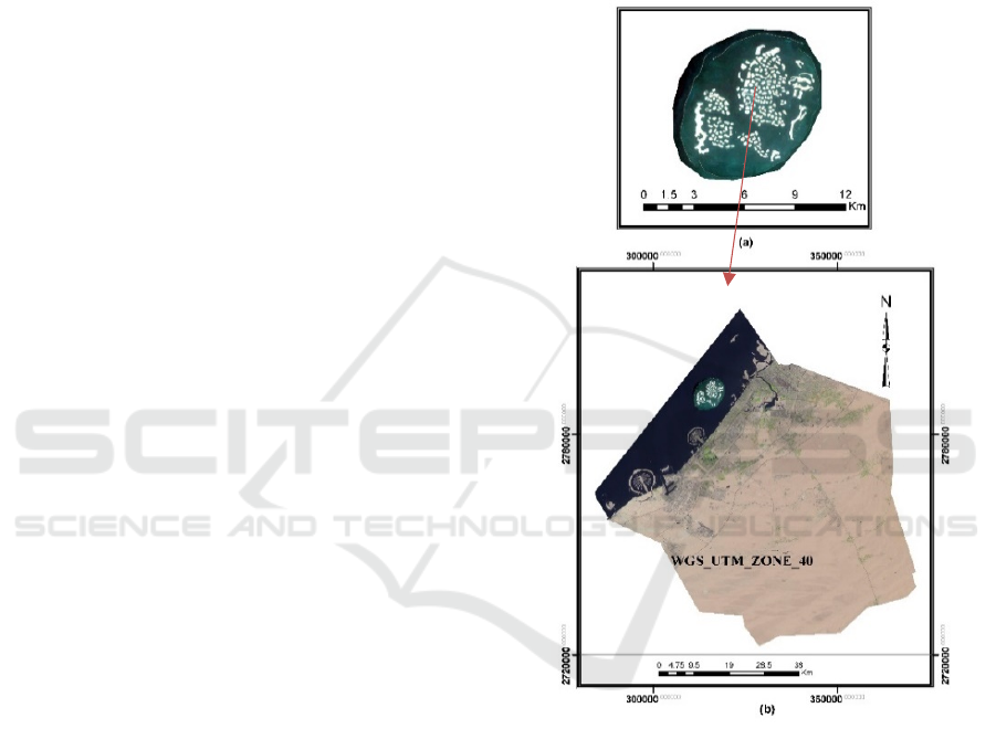
2 STUDY AREA
The world island in Dubai city, United Arab Emirates
(UAE) is located in water along the northern coast of
the Arabian Gulf on the Arabian Peninsula about
4.0m of the coast of Dubai city with a central
coordinate of 25°13' 40" N 55° 9' 54" E, Figure 1(a),
(b) shows in sequence world island image within
Landsat image of Dubai city.
Figure 1: Study Area (a) World island, (b) Dubai / UAE.
The world islands project was designed to have
300 artificial Islands that range from 14,000 to 42,000
square meter in area, where 232 km of shoreline was
Roughly created. The initial concept of this island is
to bond the mankind through the world regardless of
race, origin, and religion.
The world islands represent an ideal case for this
study where registration features such as point and
lines are unavailable and the use of polygon for
registration (island) would be mandatory.
Polygon-based Technique for Image Fusion and Land Cover Monitoring; Case Study World Islands/UAE
257
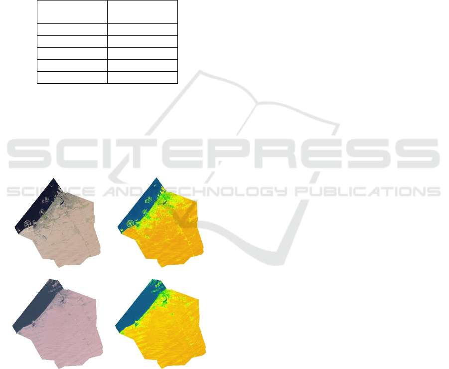
3 GEOSPATIAL DATA
The data used in this research include a diversity of
satellite images with different radiometric and
geometric resolution captured in different years.
These data will be used for image registration and
change detection. Table 1 lists the source of each
image including capturing data and the spatial
resolution in meters. Figure 2-a shows a sample of the
Landsat images for the study area for years 2004 until
2016.
Table 1: Landsat images captured at various years.
Year Resolution
(m)
2016 15
2010 15
2008 30
2006 30
2004 30
Figure 2 shows two Multi-temporal Landsat
images (the year 2016 and 1995) for Dubai city
associated with unsupervised classification where
visual inspection can show the amount of changes in
the whole city from 1995 until 2015. Various land
features that appear off shore in 2016 that was not
existing at the year 1995.
2016
1995
Figure 2: Multi-temporal Landsat images (the year 2016
and 1995) for Dubai city Associated with Unsupervised
Classification.
4 METHODOLOGY
In this paper image registration based on polygon
feature, and pixel–pixel subtraction has been
implemented using Landsat images that have
different spatial and temporal resolution. Multi-
temporal imagery over the city Dubai (world islands)
has been used and registered to the Landsat image
captured at 2016.
Image registration procedure necessarily deals
with four main topics; registration primitives, a
transformation function, similarity measure, and
matching strategy(Al-Ruzouq et al. 2012). Polygon
features (registration primitives) are usually available
in urban areas can be automatically extracted from the
images. These features (islands in urban areas) were
used as the base for change detection. After finding
the transformation function between the reference
and input images, one can be transformed into the
other image, Figure 2 shows an example of Landsat
clipped image after image registration and resampling
process. The resampling is followed by applying
canny edge detection and majority filter to both
images. Then, the resulting images are subtracted to
produce a change image, which is enhanced by
application of the majority filter. Section 4.1 will
discuss the theory and principle of the image
registration process. Change detection criteria and
stages will be discussed in section 4.2.
4.1 Image Registration
Image registration aims at geometrically overlaying
multiple images so that corresponding pixels and
landscapes elements (roads, buildings, boundaries
etc.) representing the same feature in object space
may be fused (Al-Ruzouq & Habib 2012).
To start the registration process, the appropriate
elements that will be used for registration must be
selected (for example, discrete points, linear
landscape elements such as roads, or closed regions
that compose polygons). In this research,
homogeneous regions represented by world island
polygons have been used as the registration
primitives, Figure 3. Canny Edge detection (Canny
1986) has been used to extract polygons for the study
area. Various image processing techniques and
enactment have been implemented to capture the
closed polygons, for example, the Gaussian filter was
used to smooth the image and remove the noise where
non-maximum suppression was also applied to get rid
of spurious response to edge detection. To finalize the
GISTAM 2017 - 3rd International Conference on Geographical Information Systems Theory, Applications and Management
258

detection of whole polygons, thresholding and edge
connection were conducted.
Figure 3: World islands image and extracted polygons.
The database has been established for all vector
polygons features. The database will act as a signature
that will be used to identify each polygon depending
on centroid coordinate, area, polygon perimeter and
curvature parameters
.
For Mathematically describing the relation
between the imagery in question, considering the
narrow angular field of view over relatively
approximately flat terrain, affine transformation,
Equation 1, can be used to overlay the reference and
input images properly.
y
x
bb
aa
b
a
y
x
21
21
0
0
(1)
Where
),( yx
; reference image coordinate,
),( yx
; input image coordinate.
While choosing homogeneous regions (polygons)
as registration elements, mathematical constraints to
validate the corresponds between related polygons is
required. Let’s assume that a polygon A, B and C in
the reference image corresponds to the polygon A’,
B’ and C’ in the input image. Once selecting polygon,
A, the centroid will be exerted and surrounded by the
buffer to find the nearest two other centroids of
polygons B and C. A’ can be identified manually
(conjugate of Polygon A) where A’ and B’ can be also
identified based on centroid and buffer criteria. The
three points from each image(centroid) will be used
to extract the initial parameters of the affine
transformation. The initial parameters will be used to
transfer one image to another where polygons
geometry can be compared based on centroid
coordinate, area, polygon perimeter and curvature
parameters. The results would allow for initial
filtering of the matched polygons based on accepted
threshold. Polygons that pass the previous step will
contribute in the subsequent stage where corresponds
elements and parameters of transformation function
can be simultaneously calculated based on least
square adjustment procedure.
The constraints must mathematically overlay
polygon A with the corresponding polygon A’ after
applying the transformation function. Such constraint
can be satisfied by forcing the perpendicular distances
between the endpoints of a line segment (line
connecting two centroids) in the reference image,
after applying the transformation function, and the
corresponding line segment in the input image to be
zero. The constraint can be mathematically described
using Equation 2.
0sincos
11
yx
(2)
Where
),(
: polar reference image coordinate,
),( yx
; input image coordinate after applying the
transformation function. two points from two
adjacent polygons can be used to composed line
segments needed for the suggested constraint. This
process will be repeated for each segment connected
between two centroids in a sequence order. the
resulted parameters of affine transformation will be
used to fill an array for each parameter and find value
with higher frequency (most probable value). It has to
be mentioned that size of the array for parameter
depends on the confidence of the input values such as
the resolution of the images and centroid extraction
algorithm, the whole process can be repeated with
shorter array width as shown in Figure 4.
Polygon-based Technique for Image Fusion and Land Cover Monitoring; Case Study World Islands/UAE
259
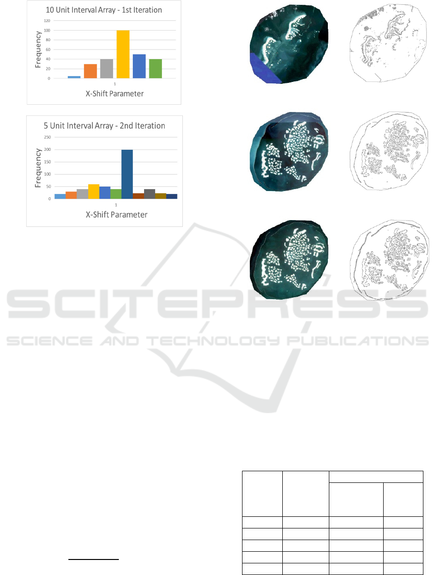
Figure 4: Frequency of parameters with different width
interval.
4.2 Change Detection
After deriving the parameters of the registration
transformation function, one of the images can be
resampled into the reference frame associated with
the other one. Within the resampled images,
corresponding pixels are assumed to point to the same
object space feature. Therefore, a simple pixel-by-
pixel comparison/differencing between the resampled
images could be used to highlight object space
changes. The suggested change detection
methodology starts by extracting edge cells using
canny edge detector (Canny, 1986). Figure 5 shows a
sample of derived edges for the study area at different
years. The filtered images will highlight areas with
interesting features since they would lead to a dense
distribution of edge cells. Afterward, the filtered
images are subtracted to highlight areas of change
To quantify the changes in the world islands, the
study utilized the Annual Urban Spatial Expansion
Index (AUSEI) proposed by (Aljoufie et al. 2013).
The index describes the temporal changes of an urban
area in terms of its annual urban growth rate and
annual growth rate. The AUSEI is computed as
shown in equation 3:
AUSEI
/
100 (3)
2004
2010
2015
Figure 5: Multi-Temporal images with extracted polygons.
Where AUSEI is the annual urban spatial
expansion index for year t; U_t and U_(t-1) are the
total urban areas of the study area in hectares at
current year t and former year t-1, respectively; and N
is the total number of years from current year t and
former year t-1, respectively2. Table 2 shows the total
urban area and the computed AUSEI indices during
the past 12 years.
Table 2: 12 years AUSEI indices.
Year
Changes
(Km2)
AUSEI
Period
Index
Value
(%)
2016 8.7 2010-2016 3.6%
2010 10.6 2008-2010 16.5%
2008 7.1 2006-2008 16.2%
2006 4.8 2004-2006 20.8%
2004 2.8 -
GISTAM 2017 - 3rd International Conference on Geographical Information Systems Theory, Applications and Management
260

5 CONCLUSION AND FUTURE
WORK
This paper presents a polygon-based image
registration together with a suggested procedure for
detecting changes between the involved images. The
approach has been tested on real datasets, which
showed its effectiveness in registering and detecting
changes among multi-temporal and multi-resolution
imagery.
The illustrated procedure has been used for image
registration of multi-source imagery with varying
geometric and radiometric properties. The presented
approach used polygon features (islands) as the
registration primitives since they can be reliably
extracted from the images. To avoid the effect of
possible radiometric differences between the
registered images, due to different atmospheric
conditions, noise, and/or different spectral properties,
the change detection is based on derived edge images.
The use of polygons vectors is attractive since it
would lead to an effective detection of urbanization
activities. The images are then subtracted to produce
a change image, which could be enhanced by
applying an image processing filters to remove noise.
The change detection results are found to be
consistent with these visually identified. Future
research will concentrate on using high-resolution
images for change detection at the same time
establishing ground truth for quantitative evaluation
of the suggested approach.
REFERENCES
Agouris, P., Mountrakis, G. & Stefanidis, A., 2000.
Automated Spatiotemporal Change Detection in Digital
Aerial Imagery. In SPIE Proceedings.
Al-Ruzouq, R.I. et al., 2012. Multiple source imagery and
linear features for detection of urban expansion in
Aqaba City, Jordan. International Journal of Remote
Sensing, 33(8), pp.2563–2581. Available at:
http://www.tandfonline.com/doi/abs/10.1080/0143116
1.2011.616917.
Al-Ruzouq, R.I. & Abueladas, A.A., 2013. Geomatics
techniques and ground penetration radar for
archaeological documentation of Al-Salt castle in
Jordan. Applied Geomatics, 5(4), pp.255–269.
Al-Ruzouq, R.I. & Habib, A.F., 2012. Linear features for
automatic registration and reliable change detection of
multi-source imagery. Journal of Spatial Science,
57(1), pp.51–64.
Aljoufie, M. et al., 2013. Spatial-temporal analysis of urban
growth and transportation in Jeddah City, Saudi Arabia.
Cities, 31, pp.57–68. Available at:
http://dx.doi.org/10.1016/j.cities.2012.04.008.
Boardman, D. et al., 1996. An automated image registration
system for SPOT data. International Archives of
Photogrammetry and Remote Sensing, 31(4), pp.128–
133.
Bruzzone, L. & Prieto, D.F., 2015. Unsupervised Change
Detection. IEEE Transactions on Geoscience and
Remote Sensing, 38(3), pp.1171–1182.
Canny, J., 1986. A Computational Approach to Edge
Detection. IEEE Transactions on Pattern Analysis and
Machine Intelligence, PAMI-8(6), pp.679–698.
Cavallaro, A. & Touradj, E., 2001. Change Detection Based
on Color Edges. In Proc. of IEEE International
Symposium on Circuits and Systems (ISCAS-2001).
Dare, P. & Dowman, I., 2001. An improved model for
automatic feature-based registration of SAR and SPOT
images. ISPRS Journal of Photogrammetry and Remote
Sensing, 56(1), pp.13–28.
Dowman, I., 1998. Automated procedures for integration of
satellite images and map data for change detection: the
archangel project. International Archives of
Photogrammetry and Remote Sensing, 32, pp.162–169.
Fonseca, L.M.G. & Manjunath, B.S., 1996. Registration
Techniques for Multisensor Remotely Sensed Imagery.
Photogrammetric Engineering & Remote Sensing,
62(September), pp.1049–1056.
Hsieh, J. et al., 1997. Image Registration Using a New
Edge-Based Approach. Computer Vision and Image
Understanding, 67(2), pp.112–130.
Nassar, A.K., Alan Blackburn, G. & Duncan Whyatt, J.,
2014. Developing the desert: The pace and process of
urban growth in Dubai. Computers, Environment and
Urban Systems, 45, pp.50–62. Available at:
http://dx.doi.org/10.1016/j.compenvurbsys.2014.02.00
5.
Seedahmed, G. & Martucci, L., 2002. Automated image
registration using geometrically invariant parameter
space clustering (GIPSC). International Archives of the
Photogrammetry, Remote Sensing and Spatial
Information Science, 34(3A), pp.318–323.
Singh, A., 1989. Digital Change Detection Techniques
Using Remotely Sensed Data. International Journal of
Remote Sensing, 10(6), pp.989–1003.
Wolfson, H., 1990. On curve matching. Intelligence, IEEE
Transaction on Pattern Recognition and Machine,
12(5), pp.483–489.
Polygon-based Technique for Image Fusion and Land Cover Monitoring; Case Study World Islands/UAE
261
