
Specifying the Technology Viewpoint for a Corporate Spatial Data
Infrastructure using ICA's Formal Model
Rubens Moraes Torres
1
, Italo Lopes Oliveira
2
, Jugurta Lisboa-Filho
1
,
Carlos Alberto Moura
3
and Alexander Gonçalves Silva
3
1
Departamento de Informática, Universidade Federal de Viçosa, Viçosa, MG, Brazil
2
Departamento de Informática e Estatística – Universidade Federal de Santa Catarina, Florianópolis, SC, Brazil
³Companhia Energética de Minas Gerais (Cemig), Belo Horizonte, MG, Brazil,
Keywords: Spatial Data Infrastructure, RM-ODP, Technology Viewpoint, ICA Model, SDI-Cemig.
Abstract: In the quest to create a formal model for the development of Spatial Data Infrastructure (SDI), the
International Cartographic Association (ICA) has proposed a model based on the RM-ODP framework to
describe SDIs regardless of the implementation and technology. The RM-ODP framework comprises five
viewpoints. The ICA has proposed the specification of the Enterprise, Computation, and Information
viewpoints while the Engineering and Technology viewpoints are yet to be specified. The Companhia
Energética de Minas Gerais (Minas Gerais Power Company - Cemig) develops an SDI, called SDI-Cemig,
aiming to facilitate the discovery, sharing, and use of geospatial data among its employees, partner companies,
and consumers. This study presents the specification of the technologies that comprise the components of
SDI-Cemig using the Technology viewpoint integrated to ICA’s formal model.
1 INTRODUCTION
Users work with a Spatial Data Infrastructure (SDI)
in order to recover or perform operations with
geospatial data (e.g., converting geographic
coordinate systems), which enable spatial-temporal
analyses and the use of decision-making support
mechanisms (Jhummarwala et al., 2014).
Based on the SDI concept, several initiatives both
in the public and private sectors have been developed
for the use, sharing, and recovery of geospatial data
aiming to create an environment in which people can
cooperate with each other and interact to reach
political and administrative goals in an optimized
manner (Alencar et al., 2013). According to Harvey
et al. (2012), SDIs improve the sharing and use of
geospatial services and helps different users of a
given community.
The Companhia Energética de Minas Gerais
(Minas Gerais Power Company – Cemig) is a
company acting in the power sector in Brazil,
currently a corporation comprehending over 200
businesses, that delves in power generation,
transmission, and distribution, besides gas
distribution and communications networks (Cemig,
2016).
Cemig develops an SDI called SDI-Cemig aiming
to help its employees, partner companies, and clients
share and discover geospatial data. The company has
created a project with the participation of other
governmental organizations in order to create this
SDI. The research and development project
“Geoportal Cemig – SDI-Based Corporate GIS” is the
result of a partnership between Cemig and the
Fundação de Amparo à Pesquisa do Estado de Minas
Gerais (Research Support Foundation of the State of
Minas Gerais - Fapemig). One of the goals of this
project consists in creating a method to develop
corporate SDIs (Alves et al., 2016).
For SDI specification and development, the
International Cartographic Association (ICA)
proposes a model based on the Reference Model for
Open Distributed Processing (RM-ODP) framework.
ICA’s model for SDI specification describes three of
the five viewpoints in the RM-ODP framework:
Enterprise, Information (Hjelmager et al., 2008), and
Computation (Cooper et al., 2013). The other two
viewpoints of the framework, Engineering and
Technology, have not been described in ICA’s model
and were left open with the caveat of being dependent
on the implementation to be used (Cooper et al.,
2011).
Torres, R., Oliveira, I., Lisboa-Filho, J., Moura, C. and Silva, A.
Specifying the Technology Viewpoint for a Corporate Spatial Data Infrastructure using ICA’s Formal Model.
DOI: 10.5220/0006311503330340
In Proceedings of the 19th Inter national Conference on Enterprise Information Systems (ICEIS 2017) - Volume 2, pages 333-340
ISBN: 978-989-758-248-6
Copyright © 2017 by SCITEPRESS – Science and Technology Publications, Lda. All rights reserved
333
Other researchers have extended the Enterprise
viewpoint, specializing the description of the actors
and policies of an SDI (Cooper et al., 2011; Béjar et
al., 2012; Oliveira and Lisboa-Filho, 2015).
According to Oliveira et al. (2016a), ICA’s formal
model can be used to specify corporate SDIs. Torres
et al. (2016) developed a modeling on the engineering
viewpoint for a corporate SDI based on the RM-ODP
model.
According to Putman (2000), the Technology
viewpoint enables specifying an architecture of
technologies to be employed in the implementation of
hardware and software according to the features
described in the other four viewpoints.
This way, this paper presents the specification of
the Technology viewpoint for SDI-Cemig based on
ICA’s adapted formal model for SDI. The paper is
structured as follows. Section 2 describes ICA’s
formal SDI model. Section 3 presents the
specification of the Technology viewpoint for the
case study of SDI-Cemig. Section 4 presents the final
considerations and possible future works.
2 ICA’S FORMAL MODEL FOR
SDI SPECIFICATION
RM-ODP is a framework for the specification of
heterogeneous distributed systems that provides
distribution, interoperability, portability, and
platform and technology independence (Farooqui et
al., 1995). The framework results from a partnership
among the International Organization for
Standardization (ISO), the International
Electrotechnical Commission (IEC), and the
Telecommunication Standardization Sector
(Raymond, 1995).
The RM-ODP framework is made up of five
viewpoints, each one representing an architectural
viewpoint of the system (Egyhazy, 2004). Since each
viewpoint does not represent an isolated part of the
system, it describes a different way of observing the
same system (Putman, 2000). By using these
viewpoints, the model is specified in five smaller
models, where each viewpoint deals with specific
relevant issues for different users (Linington et al.,
2011).
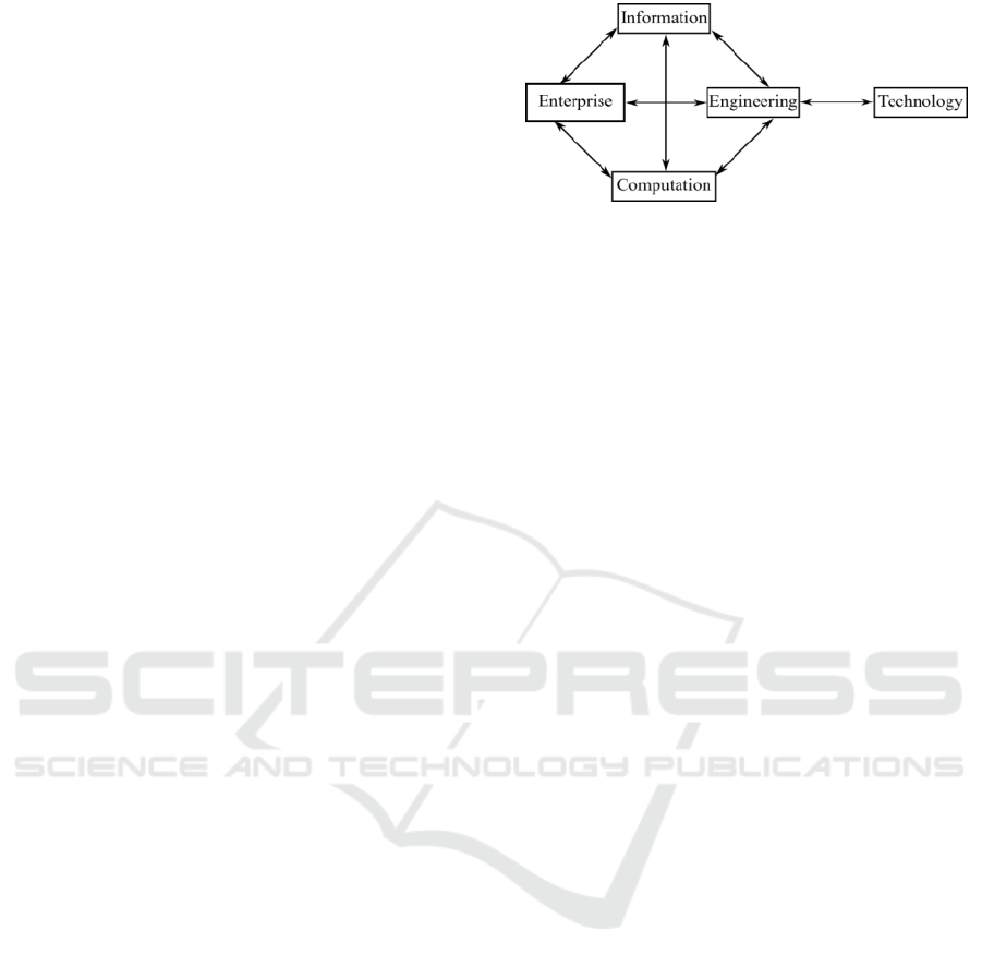
Figure 1 illustrates the five viewpoints of the RM-
ODP model. The definitions proposed by Linington
et al. (2011) and Putman (2000) on each viewpoint
are summarized below:
Figure 1: RM-ODP framework viewpoints – Adapted from
Hjelmager et al. (2008).
The Enterprise viewpoint is responsible for the
scope and policies for project composition, the
step in which the system requirements will be
defined.
The Information viewpoint works with semantics
of the information and its processing, describing
the structures and types of data used in the system.
The Computation viewpoint is related to
functionalities, whose viewpoint of the system is
a division of several functionalities. In this view,
there is concern in describing the functionalities
provided by the system in terms of objects and
those functionalities are broken down into
functional objects with interaction through their
own interfaces.
The Engineering viewpoint is built observing
mechanisms and features needed to support
interactions among the system functionalities
described in the Computation viewpoint. There is
concern in defining logical units for processing
and information, focusing on its logical
distribution, as well as its communication in terms
of communication channels. Moreover, the
Engineering viewpoint focuses on the distribution
among components and channels for its
communication.
The Technology viewpoint is related to the needs
of the system regarding the technologies required.
It describes the technologies for information
processing, functionalities, and visualization.
In Hjelmager et al. (2008), the ICA proposed
using the RM-ODP model as a reference to design
and create an SDI. By using it, one can model the data
semantics, policies (Hjelmager et al., 2008), actors
(Hjelmager, 2008; Cooper et al., 2011), objects, and
functionalities required in an SDI (Cooper et al.,
2013). The model has the advantage of being highly
independent from implementation and technology
(Hjelmager et al., 2008). Organizations at different
levels (e.g., national, regional, local, corporate) can
use the same modeling when implementing their SDIs
and one organization may choose to use a specific set
ICEIS 2017 - 19th International Conference on Enterprise Information Systems
334

of technologies while another may implement the
project with a different set (Putman, 2000).
This study approaches the Technology viewpoint
of SDI-Cemig. The definitions detailed in the
Enterprise and Information viewpoints can be found
in Oliveira and Lisboa-Filho (2015) and Oliveira et
al. (2016a), the Computation viewpoint was
presented in Oliveira et al. (2016b), and the
Engineering viewpoint was presented in Torres et al.
(2016).
2.1 Technology Viewpoint
According to Putman (2000), the Technology
viewpoint provides a view in terms of software and
hardware in the construction of the system, minimum
technology requirements needed, as well as evolution
of its useful life. This viewpoint represents a concrete
view of the components created in the other
viewpoints of the RM-ODP framework aiming to
describe the components that will receive the
products and technologies for the implementation,
besides allowing the components to be verified for
adequacy (Raymond, 1995).
The RM-ODP model provides structures to be
used in its composition during creation. The ISO/IEC
10746-3:2009(E) (2010) norm describes the
following structures to be used when creating the
Technology viewpoint: Technological Object;
Implementation Standard, and IXIT (Implementation
eXtra Information for Testing).
The technological specification is based on the
use of Technological Objects, components that
abstract a piece of hardware or software to be used in
the system implementation (Linington et al., 2011).
According to Wnuk et al. (2014), the
compatibility among distinct technologies is
constantly advancing. Companies that develop
hardware and software tend to create their products so
that they are increasingly more compatible with
technologies from other manufacturers for them to be
able to work along in a harmonious and functional
manner. However, some technologies are still
incompatible among themselves. Given this possible
incompatibility, schemas relating the set of
components and technologies used to verify the
system’s compatibility and performance must be
specified (Linington et al., 2011). In order to cover
this demand, the RM-ODP model recommends the
definition of Project Implementation Standards, a
diagram in which the technologies employed are
specified related to their respective Technological
Objects (ISO/IEC 10746-3:2009(E), 2010).
Technological Objects may be followed by basic
information to be verified in its implementation and
test. In order to add this content, the RM-ODP
framework defines the IXIT (Implementation eXtra
Information for Testing) concept. IXIT contains extra
information that guides the project implementation to
verify its basic functioning needs. Its creation consists
in text elements attached to the Technological Objects
to be specified (Putman, 2000).
3 SPECIFICATION OF THE
TECHNOLOGY VIEWPOINT:
SDI-Cemig CASE STUDY
This section presents the specification of the
Technology viewpoint of SDI-Cemig. The elements
of this viewpoint were specified according to the
components documented in the viewpoints Enterprise
(Oliveira et al., 2016b), Computation (Oliveira et al.,
2016a) and Engineering (Torres et al., 2016).
The diagram created consists in nine
Technological Objects representing firewalls,
networks, servers, and the system user as illustrated
in Figure 2. Its creation is based on the requirements
described by the previous viewpoints of ICA’s model
for the SDI-Cemig model in Oliveira et al. (2016b),
Oliveira et al. (2016a), and Torres et al. (2016) and by
Cemig’s Technical Report N.002/2016 (Alves et al.,
2016).
The element RemoteSystem represents a system
user who wishes to access SDI-Cemig. To that end,
the user has two interfaces: A web browser and
services for communication with traditional
softwares for Geographic Information System (GIS)
handling. There are two Technological Objects
representing firewalls for access control to the
system.
The first element, ExternalFirewall, consists
in a protection against external breaches and
unauthorized access, controlling all connections
among the servers in the CemigLAN network with
computers in external WAN networks. The second
firewall, InternalFirewall, consists in extra protection
for the access to information for the component
DataServer, a server containing geographic
information and managed by a database.
Its creation complies with a norm by Cemig
according to which there must be extra protection for
the access to the server storing geographic data
(Alves et al., 2016).
The other Technological Objects represent four
servers responsible for several features in the system.
They are made up of the following components:
PortalCemigServer, CataloguerServer, DataServer,
Specifying the Technology Viewpoint for a Corporate Spatial Data Infrastructure using ICA’s Formal Model
335
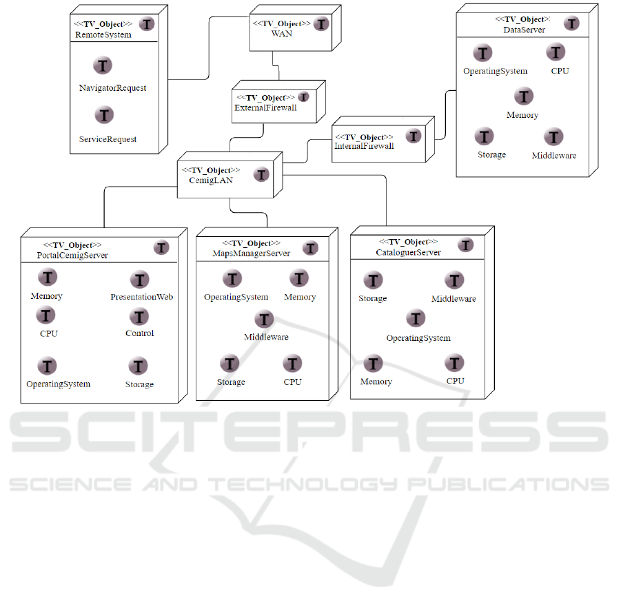
Figure 2: Technological Objects of SDI-Cemig.
and MapsManagerServer.
The Technological Object DataServer represents
a server where geographic information is stored. It
stores information in a database capable of storing
and managing spatial data.
MapsManagerServer is a server responsible for
generating a graphical visualization of data from
information provided by the object DataServer. It
must reply to calls from web browsers and web
services.
CataloguerServer consists in a server that
provides a catalog with geographic information
available for the user in the database. The information
must be provided along with their metadata, which
follow the Brazilian Geospatial Metadata Profile
(MGB) (CONCAR, 2009).
Finally, the object PortalCemigServer consists in
a server in charge of providing a web interface for the
object RemoteSystem, whose interface allows
accessing the following system functionalities for the
Engineering viewpoint (Torres et al., 2016):
PortraitSDICemigOps, DataSDICemigOps, and
CatalogSDICemigOps. In order to meet those needs,
the server communicates with the objects
MapsManagerServer for map generation,
CataloguerServer to obtain a data catalog, and
DataServer to obtain geographic data from the
geographic information database.
Fonseca (2016) analyzed and compared several
softwares and technologies available on the market to
be used in SDI implementations. That study proposed
several tools to work with components in an SDI,
such as a map server, data server, and information
catalog.
PortalCemigServer is responsible for the
browsing interface using technologies that may be
implemented on a website (e.g., OpenLayers,
AngularJS). To that end, the technologies chosen are
familiar to the company and preferred by it (Alves et
al., 2016).
For the construction of internal components of the
servers MapsManagerServer, CataloguerServer, and
DataServer, which have specialized purposes, the
technologies chosen were suggested by Fonseca
(2016) and comply with CEMIG. Figure 3 illustrates
the use of those technologies linked to their respective
Technological Objects.
The PortalCemigServer server has the
components PresentationWeb and Control. The
component PresentationWeb represents the system
ICEIS 2017 - 19th International Conference on Enterprise Information Systems
336

visualization layer and the use of the AngularJS
1
framework was proposed for its construction. For the
component Control, the Ruby on Rails
2
framework
was designated.
For the servers MapsManagerServer,
CataloguerServer, and DataServer, the softwares
MapServer
3
, GeoNetwork
4
, and PostgreSQL
5
,
respectively, were designated.
Those softwares, according to Fonseca (2016), are
well adequated as components when building SDIs.
Aiming to contemplate the need to replicate data in
the Engineering viewpoint (Torres, 2016), the server
DataServer uses the technology Redundant Array of
Independent Disks (RAID) for the component
Storage (Ellis et al., 1996).
The component RemoteSystem has the element
NavigatorRequest, which is represented by a browser
that uses HyperText Markup Language 5 (HTML5)
to access the system via the web.
The components CemigLAN, WAN,
ExternalFirewall, and InternalFirewall do not have
extra specification for being established standards
representing networks and firewalls.
Figure 4 represents the IXIT diagram of the SDI-
Cemig model. The diagram contains additional
information that must be observed in the
technological implementation process. The
operational system versions are defined by Cemig and
do not restrict migrating to another system as long as
based on a Linux environment.
Hardware specifications represent the minimum
hardware that must be used in the project and are
based on the minimum specifications defined by each
respective technology provider. The software
versions defined are the current versions and serve as
guidance, with no restriction against the use of a more
recent version. However, the use of new versions
requires the verification of continued compatibility
and interoperability among the technologies
employed. New system functionalities can be
included with the creation of new technological
components provided that those components have a
communication interface in common with the rest of
the system and have a service-oriented
communication architecture.
The IXIT diagram describes the main
communication rules that must be verified in the
implementation among components. The
RemoteSystem must have software compatible with
___________________________
1
https://angularjs.org/
2
http://rubyonrails.org/
the Web Map Service (WMS) and Web Feature
Service (WFS) standards for the use of different web
services, whether from other SDIs or not, and
HTML5 for the browser interface. CataloguerServer,
with the use of GeoNetwork, must be able to access
the GeoServer software and the PortalCemigServer
component through a Representational State Transfer
(REST) interface (Fielding, 2000).
MapsManagerServer must allow access through the
WMS and WMF standards. PortalCemigServer and
DataServer must communicate based on REST.
The Technology viewpoint (Figure 3) implements
the components described in terms of functionalities
by the Computation viewpoint of SDI-Cemig
(Oliveira et al., 2016a). The elements of the
Technology viewpoint are listed below with their
corresponding components in the Computation
viewpoint:
The component RemoteSystem corresponds to the
components User, Provider, Operational Body,
and Cataloguer;
PortalCemigServer contemplates the user
interfaces proposed in the package
User_Interfaces;
The server MapsManagerServer serves
Portrayal_SDI-Cemig, responsible for map
visualization;
CataloguerServer serves Metadata_Management
and Catalog_Management for information
cataloging along with their corresponding
metadata;
DataServer contemplates the objects Data_SDI-
Cemig, Data_Vectors_Management, and
Data_Rasters_Management, responsible for the
management of information in the database.
3
http://www.mapserver.org/
4
http://geonetwork-opensource.org/
5
http://www.postgresql.org/
Specifying the Technology Viewpoint for a Corporate Spatial Data Infrastructure using ICA’s Formal Model
337
Figure 3: Standards for SDI-Cemig implementation.
ICEIS 2017 - 19th International Conference on Enterprise Information Systems
338
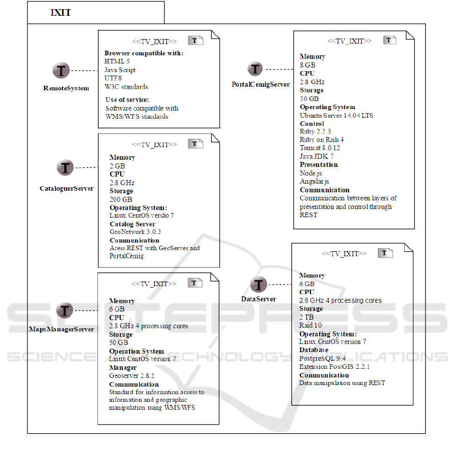
Figure 4: IXIT diagram for SDI-Cemig.
4 FINAL CONSIDERATIONS
With the specification of the fifth viewpoint of ICA’s
model, SDI-Cemig has a model contemplating all five
viewpoints of the RM-ODP framework, which allows
the model to be consulted as a whole. In other words,
the specification of all viewpoints provides an
overall, specialized view of SDI-Cemig.
The Technology viewpoint comprises
Technological Objects representing from physical
components to functionalities, where they are
organized independently and isolated from each
other. Its communication is performed through a
service-oriented architecture in which a
Technological Object makes a request to another
component through a common communication
interface.
Although the viewpoint created defines
technologies to be used in the implementation of a
corporation, the specification of the Technology
viewpoint for SDI-Cemig suggests that a similar
specification could be used in other SDIs not only
corporate and related to the power sector, but also at
different levels (e.g., regional, national, local). In case
changes are desired, such as switching technologies,
the model made up of modules allows for those
changes as long as the new technology meets the
Specifying the Technology Viewpoint for a Corporate Spatial Data Infrastructure using ICA’s Formal Model
339

requirements described in the viewpoint. The use of
independent modules makes it easier to include new
functionalities in the system since new components
may be added with no significant changes to the
project.
As future works, it would be important to apply
ICA’s formal model onto broader SDIs such as at the
regional and national levels.
ACKNOWLEDGEMENTS
This research project was partially funded by
Fapemig and CAPES, along with Cemig.
REFERENCES
Alencar, C. M. S. d., Santos, P. L. V. A. d., et al., 2013.
Acesso À Informação Geográfica: Reflexões Sobre A
Importância das Infraestruturas de Dados Espaciais nas
Políticas Públicas. Liinc em Revista, p. 488-501.
Alves, A., Liboa-Filho, J., Oliveira, I., 2016. Plano de
Implantação da Infraestrutura de Dados Espaciais
SDI-Cemig. Relatório Técnico do PPGCC,
Universidade Federal de Viçosa.
Béjar, R., Latre, M. Á., Nogueras-Iso, J., Muro-Medrano,
P. R., Zarazaga-Soria, F. J., 2012. An RM-ODP
enterprise view for spatial data infrastructures. Computer
Standards & Interfaces, v. 34, n.2, p. 263-272.
Cemig, 2016. Mémoria Cemig. Available at: http://
www.cemig.com.br/pt-br/a_cemig/Nossa_Histor
ia/Paginas/default.aspx.
CONCAR – Comissão Nacional de Cartografia, 2009.
Perfil de Metadados Geoespaciais do Brasil (Perfil
MGB). Available at: http://www.concar.ibge.gov.br/
arquivo/perfil_mgb_final_v1_homologado.pdf.
Cooper, A. K., Moellering, H., Hjelmager, J., et al., 2013.
A spatial data infrastructure model from the
computational viewpoint. Int. Journal Geographical
Information Science, v. 27, n. 6, p. 1133-1151.
Cooper, A. K., Rapant, P., Hjelmager, J., et al., 2011.
Extending the formal model of a spatial data
infrastructure to include volunteered geographical
information. 25
th
Cartographic Conference (ICC).
Egyhazy C., Mukherji R., 2004. Interoperability
Architecture Using RM-ODP. Communications of
ACM, v .47, n. 2.
Ellis, R. A., Lubbers, C. E., Malan, S. J., Rivera, P., Snyder,
S., Thiel, D. W., Wells, R. B., 1996. Method and
apparatus for preserving data integrity in a multiple disk
raid organized storage system. U.S. Patent No.
5,504,858. Washington, DC.
Farooqui, K., Logrippo, L., De Meer, J., 1995. The ISO
reference model for open distributed processing: and
introduction. Computer Networks and ISDN Systems, v.
27, n. 8, p. 1215-1229.
Fielding, R. T., 2000. Architectural styles and the design of
network-based software architectures. PhD thesis,
University of California, Irvine.
Fonseca, F. J. B., Pereira, L. V. S., Lisboa-Filho, J., 2016.
Comparando Sistemas Webgis de Exibição e
Processamento de Informação Geográfica no Contexto
da INDE. Conferencia Ibérica de Sistemas y
Tecnologías de Informacion (CISTI), v. 1, p. 250-255.
Harvey, F., Iwaniak, A., Coetzee, S., Cooper, A., K., 2012.
SDI past, present and future: a review and status
assessment. Spatially Enabling Government, Industry
and Citizens.
Hjelmager, J., Moellering, H., Cooper, A. K., et al., 2008.
An initial formal model for spatial data infrastructure.
International Journal of Geographic Information
Science, v. 22, n. 11-12, p. 1295-1309.
ISO/IEC 10746-3:2009(E), 2010. Information Technology
Open Distributed Processing Reference Model:
Architecture. Standard, International Organization for
Standardization / International Electrotechnical
Commission, Switzerland.
Jhummarwala, A., Potdar, M., Chauhan, P., 2014. Parallel
and Distributed Gis for Processing Geo-Data: an
Overview. International Journal of Computer
Applications, v. 106, n. 16.
Linington, P. F., Milosevic, Z., Tanaka, A., Vallecilo, A.,
2011. Building Enterprise Systems with ODP: An
Introduction to Open Distributed Processing. CRC
Press.
Oliveira, I. L., Lisboa-Filho, J., Moura, C. A., Silva, A. G.,
2016a. Specifying the computation viewpoints for a
corporate spatial data infrastructure using ICA’s formal
model. International Conference on Computational
Science and Its Applications, p. 275–289.
Oliveira, I. L., Lisboa-Filho, J., Moura, C. A., Silva, A. G.,
2016b. Specifying the enterprise and Information
viewpoints for a corporate spatial data Infrastructure
using ICA’s formal model. Proceedings of the 18th
International Conference on Enterprise Information
Systems, v. 1, p. 271–282.
Oliveira, I. L., Lisboa-Filho, J., 2015. A spatial data
infrastructure review – sorting the actors and policies
from enterprise viewpoint. Proceedings of the 17th
International Conference on Enterprise Information
Systems, v. 17, p. 287-294.
Putman, J. R., 2000. Open Distribution Software
Architecture Using RM-ODP. Prentice Hall PTR.
Raymond, K., 1995. Reference Model for Open Distributed
Processing (RM-ODP): Introduction.
Open Distributed
Processing, p. 3-14.
Torres, R. M. T., Oliveira, I. L., Lisboa-Filho, J., Moura, C.
A., Silva, A. G., 2016. Specifying the engineering
perspective of ICA’s formal model in a corporate
spatial data infrastructure. The 9th Int. Conference on
Advanced Geographic Information Systems,
Applications, and Services (GeoProcessing 2017).
Wnuk, K., Runeson, P., Lantz, M., Weijden, O., 2014.
Bridges and Barriers to Hardware-Dependent Software
Ecosystem Participation – A Case Study. Information
and Software Technology, v. 56, n. 11, p. 1493-1507.
ICEIS 2017 - 19th International Conference on Enterprise Information Systems
340
