Facts Collection and Verification Efforts
Rizwan Mehmood and Hermann Maurer
Institute for Information Systems and Computer Media, Graz University of Technology, Graz, Austria
Keywords:
Data Quality, Information Reliability, Data Integration Systems.
Abstract:
Geographic web portals and geospatial databases are emerging on the web recently, offering information
about countries and places in the world. Digital content is increasing at a staggering rate due to community
collaboration and the integration of information from webcams and sensors. Like in case of Wikipedia, some
geospatial databases allow everyone to edit the content. We cannot ignore the role of wikis and geospatial
databases particularly Wikipedia, Wikicommons, GeoNames etc., as they have replaced the traditional ency-
clopedias and they are empowering information seekers by providing information at the door step. However,
there is no guarantee of validity and authenticity of the information provided by them. The reason behind is
that very little attention has been given to verify information before publishing it on the Web. Also, to find
particular information about countries, web users mainly teachers, students and tourists rely on search engines
such as Google which often points to Wikipedia. We will identify some inconsistencies in online facts such as
area, cities and mountains rankings using multiple data sources. Our investigations reveal that there is a need
for a reliable geographic web portal which can be used for learning and other purpose. We will explain how
we managed to devise a mechanism for collecting and verifying different facts. Our attempt to provide a re-
liable geographic web portal has resulted in a comprehensive collection covering a wide range of information
aspects such as culture, geography, economy etc. that are associated with a country. We will also describe
our approach to measure the reliability of geographic facts such as area, cities and mountains rankings for all
countries.
1 INTRODUCTION
The web has significant impact on the lives of the
people and its importance has been mounting mirac-
ulously. The culture of opening books has changed
with the invention of web. The problem is not, the
lack of information, but the reliability of information
as claimed and highlighted in (Wurzinger, 2010). The
author showed the unreliability and difference of facts
in different data sources found on the web.
One cannot imagine a web without data. But it has to
be of good quality and reliability before it can be used
for any purpose. The quality of data is a critical factor
for all kinds of decision-making and transaction pro-
cessing and its importance is also clear when used for
learning.
If we look at online information, we come across
many problems related to quality and reliability.
Sometimes a time-line is missing which is very crit-
ical in some facts such as population figures; refer-
ences are missing which can be used to factor out
more details related to an article and to judge the au-
thenticity of facts; or there are presentation of facts
without units attached to them.
Let us look at an example. We are presenting the rank-
ing of the five highest mountains of India taken from
GeoNames and WolframAlpha as shown in Table 1.
We have chosen them since GeoNames is one of the
largest and most frequently used geospatial database
and it is generally assumed to be of sufficient quality.
We can see the discrepancies in the rankings as shown
Table 1: Different mountain rankings of India in Wolfra-
mAlpha and GeoNames.
W
olfram Alpha
Ele
vation (m)
GeoNames Ele
vation (m)
Kangchenjung
a
8586 Nanda
Devi
7816
Kangchenjung
a West 8505 Kamet 7756
Kangchenjunga South
8494 Saser
Kangri
7672
Kangchenjung
a Central
8482 Kabru 7412
Distaghil
Sar
7885 Badrinath 7138
in Table 1. Kangchenjunga is ranked 1st in Wolfra-
mAlpha, where as Nanda Devi comes on top in GeoN-
ames ranking. Although Kangchenjunga is present
in GeoNames
1
, but it is associated with Nepal and is
the 2nd highest mountain in Nepal after Mount Ever-
1
geonames.org/maps/google 27.703 88.147.html
142
Mehmood R. and Maurer H..
Facts Collection and Verification Efforts.
DOI: 10.5220/0005505501420151
In Proceedings of 4th International Conference on Data Management Technologies and Applications (DATA-2015), pages 142-151
ISBN: 978-989-758-103-8
Copyright
c
2015 SCITEPRESS (Science and Technology Publications, Lda.)
est. One obvious reason for discrepancies in moun-
tain rankings is that mountain ranges often define the
border between two countries. Also, Distaghil Sar is
counted as the 7th highest peak of Pakistan, see (Ku-
lathuramaiyer et al., 2014). Another example is the
mountain Golemi Korab which is highest mountain
in both Albania and Macedonia. However this short
example forces us to dig deeper into verification of
facts for our geographic portal, using different reli-
able sources.
There are some inherent complications which are as-
sociated with some facts. When we list countries, a
main problem arises, it is not clear whether a par-
ticular geographic place is recognized as a country
or just a territory. For instance Taiwan is not rec-
ognized as a country by UN. Likewise different por-
tals present the size (area) of countries differently; for
either political reasons, or because they exclude/in-
clude lakes, glaciers and/or ocean channels. Similar
problems happen with mountains (when their peak is
at a border) or cities (in some cases only the core is
counted, in others the whole much larger metropolitan
areas). Another interesting case concerns Nobel Lau-
reates: It is also not clear how to associate them with a
particular country due to the following reasons: i) Is it
decisive where a person was born. ii) Where the per-
son obtained the award. iii) Where the person did the
work for which the award was given, etc. iv) Also, the
country where e.g. a person was born may not exist
any more! Overall, we consider the country of birth
most important, but also try to list persons under the
country they live in when the award was given. In case
of country changes, we add them to potentially more
than one country. For example Mother Teresa was
born in Ottoman Empire which is now Macedonia (a
country in Europe). She was living in India when the
Nobel prize was given and she also died in India. We
list her in both India and Macedonia. All this shows:
Questions we often pose are ill-posed. There is no
clear answer to what is the largest cave, or how many
Nobel Laureates belong to a country etc. unless the
question is formulated more specifically.
Several attempts have been made by researchers in the
past to utilize web data that is present either in tex-
tual or in structured form, see (Zhao and Betz, 2007),
(Carlson et al., 2010). We start with the facts which
we import from different data sources. Then we try
to find similar facts on other online data sources. We
verify information before using it. Verification is done
using comparative analysis of multiple data sources,
encyclopedias such as Britannica, querying maps and
and also with the help of domain experts in some
cases. We will use the terms data and fact inter-
changeably in the rest of paper. Further, we call our
geographic web portal, the AF-Geo portal
2
.
The rest of the paper is organized as follows. Sec-
tion 2 describes the kind of geographic data which we
are considering for our portal. Section 3 describes the
geographic data sources that have large sets of infor-
mation. We will highlight new ways of verifying and
collecting facts from online sources in Section 4. We
present our results regarding facts verification in Sec-
tion 5 followed by evaluation in Section 6.
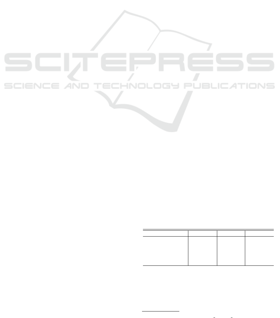
2 GEOGRAPHIC FACTS IN
CONSIDERATION
There are different types of data. Considering the
temporal dimension, we can classify types of data as
stable, long term changing and frequently changing
data as mentioned in the book (Carlo Batini, 2006). A
sample data
3
is shown in Figure 1; that can be associ-
ated with a country.
Figure 1: Types of facts related to any particular country
based on temporal dimension.
2.1 Stable Data
This type of data rarely changes. It remains constant
over a long period of time. The area of a country com-
prising of land area and water area etc. is the exam-
ple of stable data. There are some exceptional cases
when country areas are reported differently, consider-
ing issues such as the recently occurring war between
Ukraine and Russia. Another example are Pakistan
and India, both claiming parts of Kashmir long ago
since countries became independent. Similarly the
postal code of an area is hardly changed. A list of
facts including in this category is shown in Figure 1.
2
http://austria-forum.org/af/Geography
3
The list of such facts is quite long but to demonstrate
types of data we are presenting a sample
FactsCollectionandVerificationEfforts
143

2.2 Long Term Changing Data
This type of data changes but it has very low change
frequency. If we look at population, the factual data
representing population changes with time. Similar
examples are birth-rate, employment-rate etc. The
reason behind this variability of data is a process
called census which is the procedure of systematically
acquiring and recording information about a coun-
try, usually population and other facts, that belong
to a country. Once the process is over, the respon-
sible authority publishes the numbers obtained. The
population of a country is normally updated annually
whereas economic facts such as GDP are calculated
biannually or on annual basis. Similarly, Nobel prize
winners list is updated every year.
2.3 Frequently Changing Data
This type of data changes frequently. If we look at the
temperature and weather of a particular region, it con-
stantly changes every day. There are some web ser-
vices that are used to report this type of data. However
we are not considering this in our geographic portal
and we pay attention to correctness of stable and long
term changing data and apply different measures to
verify facts as described in Section 4.
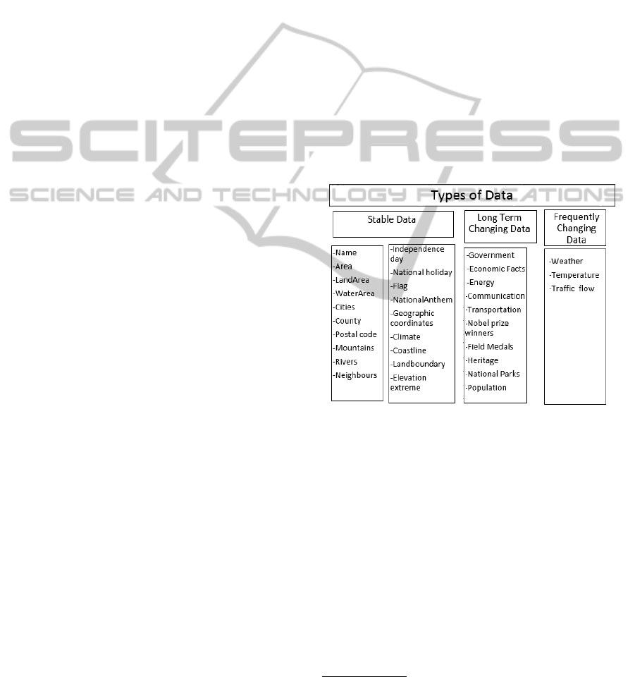
3 DATA SOURCES
This section looks at sources of information about
countries. We group data sources according to their
type, as shown in Figure 2. We will briefly look
at each type. We will explain what kinds of facts
are stored in a particular data source. We talk about
the data storage mechanism followed by extraction of
facts in this section.
3.1 Geospatial Databases
GeoNames: It contains over 8 million place names
that are available for download free of charge. The
GeoNames
4
data dump is available in the form of a
text file which requires a little bit of tweaking be-
fore importing it into SQL Server DBMS. Listing 1
shows a query to extract the 5 highest mountains from
GeoNames.
3.2 Semantic Web
DBpedia: It is one of the online structured infor-
mation resources. It contains geographic facts about
4
http://www.geonames.org/
1 select top 5 name , e l e vat i o n from G e o N a m e s
2 where c o u n t r y _ c od e =AT a nd f e at u r e _ c l a s s =T
3 and f ea t u r e _c o d e =MT a n d e le v a t i o n > 0
4 order b y e l e va t i o n desc .
Listing 1: SQL query to extract 5 highest mountains
of Austria from GeoNames.
1 PREFIX d b p p r o p : <http : / / d b pedia . org / propert y
/>
2 PREFIX db:<http : / / d b p e d i a . org / r e s o u rce />
3 PREFIX d bpe d i a−owl :<htt p : / / d b pedia . org /
reso u r c e />
4 SELECT ? pop ? co u n t r i es ? ar e a
5 WH E R E {
6 db : Asia d b p p r o p : popu l a t i o n ? pop .
7 db : Asia d b p p r o p : coun t r i e s ? co u n t ri e s .
8 db : Asia dbp e d ia−ow l : ar e a T o t al ? ar e a . }
Listing 2: SPARQL query to extract facts of Asia
from DBpedia.
the countries in the form of triples that were origi-
nally stored in the form of tables and info boxes in
Wikipedia. RDF is a language that is used to express
data in the form of triples as shown in Figure 3. The
RDF triple consists of a subject, predicate and an ob-
ject. The sparql query is used to query RDF triples.
In Line 6 shown in Listing 2, db:Asia is a subject
whereas dbpprop:population represents the property
and variable ?pop stores population of the Asia, which
is returned when query is executed.
3.3 Geographic Web Portals
CIA World Factbook: It is the most widely used on-
line information source for geography. The data can
be downloaded from CIA world factbook freely. It
provides an archive of geographic information for the
last 10 decades which can be used for statistical infer-
encing. It is updated biannually. The Factbook
5
was
selected as our starting point as there is no copyright
issues.
3.4 Computational Knowledge Engine
WolframAlpha: It is different from search engines
like Google. It is an online service that answers fac-
tual queries directly by computing the answer, rather
than providing a list of documents or web pages. Wol-
framAlpha
6
provides an API for extracting data. The
API returns data in the form of XML. It needs sub-
scription to allow open access to data. We have taken
5
https://www.cia.gov/library/
6
http://www.wolframalpha.com/
DATA2015-4thInternationalConferenceonDataManagementTechnologiesandApplications
144
Figure 2: Geographic data sources.
Figure 3: Semantic Network showing RDF Triples repre-
senting Asia.
1 C : \ >osmosi s −−rb f a u s tria . osm . pbf −− nkv
2 k e y V a lu e L i s t =” a m e n i t y . ban k ” −−wx b a n k . osm
Listing 3: Osmosis command to extract banks of
Austria from OSM file.
city and mountain rankings from Wolfram Alpha to
verify GeoNames rankings.
3.5 Encyclopedias
Britannica: It provides a general article about a
country which includes historical and cultural infor-
mation. We have used QuickFacts
7
page of each
country to verify the area of countries taken from
Factbook.
3.6 Maps
OpenStreetMap (OSM): It is freely editable map of
the world. It was started by Steve Coast in 2004. Os-
mosis is a command line Java application for process-
ing OSM data. An osmosis command which is used
to extract banks in Austria from OpenStreetMap is
shown in Listing 3.
Natural Earth: It is an online resource for free geo-
graphic dataset, maps and shape files. Natural Earth
8
7
britannica.com/EBchecked/topic/438805/Pakistan
8
http://www.naturalearthdata.com/
provides both vector and raster graphics that can be
used to draw map visualizations. It allows to down-
load vector map files representing each country.
3.7 Reliable Web Sites
This category contains those web sites which contain
valuable data such as UNESCO heritage sites, na-
tional parks and Nobel prize winners related to coun-
tries. The culture section of AF-Geo portal contains
this valuable information. We are using both links and
facts from those web sites. We redirect users to these
web sites to learn more about facts.
4 METHODOLOGY
There were two motives behind collecting facts. i) We
want to build a geographic web portal with a large
number of facts related to countries and territories.
ii) We want to automate the process of verification of
collected facts. In this section we will deal with ver-
ifying geographic facts using maps along with tech-
niques ranging from information extraction on Web,
to facts comparison stored in multiple data sources,
see (Weikum and Theobald., 2010), (Suchanek et al.,
2009).
4.1 Verification using Maps
Physical geographic data such as area of country, land
boundaries, neighbour countries of a particular coun-
try can be verified using maps. The details of data
verification using maps is highlighted in our previous
paper, see (Mehmood, 2014). Spatial operators allow
automatic calculation of geographic features. Using
spatial methods such as STArea(), STLength() we can
verify facts such as area of country, boundary length
FactsCollectionandVerificationEfforts
145
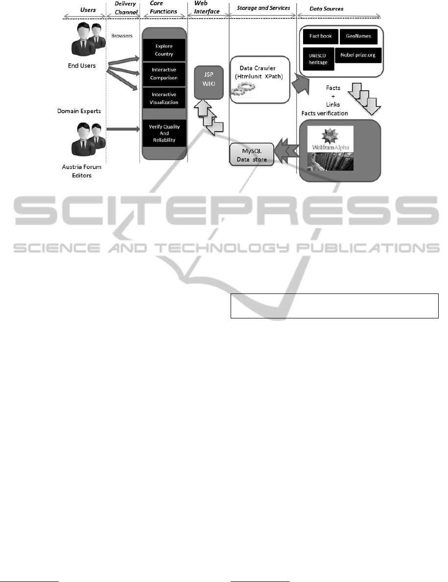
Figure 4: System Architecture.
of countries etc. The STArea() method returns the to-
tal surface area of a geographic entity such a polygon
representing a country.
4.2 Verification using Encyclopedias
Traditional encyclopedias rely on domain experts to
generate content. In contrast, Wikipedia uses “the
wisdom of crowds” i.e. relies on a large community
of users. It allows users to edit existing entries and
therefore depends on its contributors which are not
necessarily experts. Several studies have shown that
Encyclopedia Britannica is an example of an accurate
reference, see (Calzada and Dekhtyar, 2010), (Dalip
et al., 2009). We thus use Britannica, Brockhaus
9
for verification of facts. Let’s walk through the code
which is used to extract area of countries from Bri-
tannica as shown in Listing 4. We are using Htmlu-
nit
10
(a window-less browser) API. It allows to query a
web page using WebClient object, followed by infor-
mation extraction using XPath
11
expressions. Once
we have the access to table rows, using the Xpath ex-
pression (shown in line 4, 5 of Listing 4), we iterate
through the rows and extract a specific table row that
contains total area of a particular country. Afterwards,
we populate our data store Britannica which is latter
used for verification.
4.3 Verification using Reliable Sources
We also decided to go one step further and look at
other data sources discussed in Section 3. We want
9
http://www.brockhaus-wissensservice.com/
10
http://htmlunit.sourceforge.net/
11
http://www.w3schools.com/xpath/
to ensure the reliability by comparing facts with other
online geographic portals. Therefore we choose in-
foplease.com which is a reliable web portal. In In-
foplease, the area facts are stored in an HTML page;
embedded in paragraph with class area, therefore we
are capturing those <p> elements which contain the
area of country using XPath expression below.
//p[@class=’area’]/text();
Figure 4 summarizes the overall process of data
collection and verification. We extract facts from
number of data sources (a sample is shown). Af-
ter extracting facts we verify them using Britannica,
WolframAlpha and other web portals such as Info-
please
12
, World Atlas etc. for an additional check.
The code snippet to extract large five cities from Wol-
framAlpha is shown in the Listing 5. The wolfram
API returns data in the XML format. We are us-
ing python library xml.etree.ElementTree
13
for pars-
ing xml response, thus making it easy to extract cities
from WolframAlpha. Our geographic portal has static
collection of facts in the form of wiki pages which
is based on JSP wiki syntax
14
. Therefore we gener-
ate them automatically using our verified and reliable
collection of facts. A sample page is shown in Fig-
ure 7. Users and domain experts can interact with our
geographic portal and perform different activities; for
example users can explore a country and find infor-
mation related to different aspects such as geography,
economy, Nobel prize winners, parks etc. Domain
experts and editors can give their comments and up-
12
http://www.infoplease.com/
13
docs.python.org/2/library/xml.etree.elementtree.html
14
http://www.ecyrd.com/JSPWiki/wiki/TextFormattingRules
DATA2015-4thInternationalConferenceonDataManagementTechnologiesandApplications
146
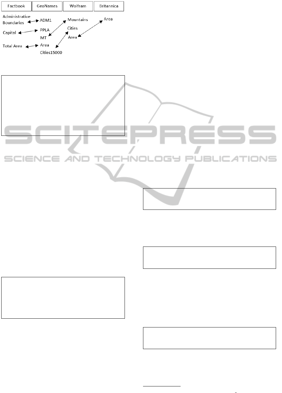
Figure 5: Schema Matching. Double sided arrows show
similarity between concepts.
1 String URI =” b ri t a n n i c a . com / topic / ” + c o u n t r y +”−
qu ick−f a cts ” ;
2 We b C l i e n t c l i e n t = n ew W e b Cl i e n t ( ) ;
3 Htm l P a g e m a i n P a g e = c l i e n t . getPa g e ( URI ) ;
4 links1 = ( List <?>)m a i n P a ge . ge t B y X P a th ( ” / / tr [
@class = ’ eb−pr o file−tab le−even ’ ] ” ) ;
5 H t m l T ab l e R o w tr =( H t m l Ta b l e R ow ) ( li n k s 1 . ge t ( j ) )
;
6 links2 =tr . ge t Ch i l d N o d e s ( ) ;
Listing 4: Webpage parsing using Htmlunit and
Xpath to extract area of countries from Britannica for
verification.
date the existing wiki pages after log in. Interactive
data visualisations are also provided for meaningful
understanding of geography.
We now discuss the comparison of facts. This
was a difficult procedure posing several challenges.
Different data sources use different underlying names
and schemas, see (Rahm and Bernstein, 2001), (Bel-
lahsene et al., 2011) and (Bernstein et al., 2011). Fig-
ure 5 is showing concepts in different data sources
and double sided arrows indicate similarity between
two concepts in different data sources. For instance,
ADM1 is a feature code in GeoNames and it repre-
sents administrative boundaries of a country such as
provinces and districts; it is similar to the concept Ad-
ministrative Boundaries in Factbook.
1 _q=L a r g e + five +c i t i e s +of +”+ c o u n t r y
2 ur l =” a p i . wo l f r a m a l p h a . com / qu e r y ? input =_q ”
3 res p o n s e = urllib2 . urlope n ( url )
4 tr e e =E T . pa r s e ( re spon s e )
5 ro o t = tree . g e t r o o t ( )
6 cities =r o o t [ 0 ] [ 0 ] [ 0 ] . te x t
Listing 5: Python code snippet to extract large five
cities from WolframAlpha.
Area comparison was easy, as numbers represent-
ing area of country are easily compared using the sim-
ilarity function in excel sheet. But prior to that, inte-
grating facts and filling them into excel sheet was a
tedious procedure. We also have to state here that our
semi-automatic approach of verification of facts using
data sources was only successful because of the pow-
erful tools such as Htmlunit and Xpath. By harness-
ing the power of both, we succeeded in extracting the
facts from Britannica, WolframAlpha and Infoplease
which stores data in textual form, for verification.
5 RESULTS AND DISCUSSIONS
This section presents the summarized results of the
verification process. The continent-wise city ranking
results based on population, using two data sources
(WolframAlpha, GeoNames) are shown in Table 2.
For this particular study we are presenting top 5 city
rankings. City rankings are found correct in case of
73 out of 193 countries (UN member states); whereas
in case of 110 countries, city rankings did not match.
We classified our verification results as: i) Verified
ii) Partially Verified iii) Verified+Explanation iv) Not
Verified. Verified rankings are rankings of those
countries where two lists representing cities and their
ranks exactly match. Partially Verified rankings are
rankings of those countries where two lists partially
match. For instance, the city list of Sao Tome and
Principe shown below is representing Partially Veri-
fied case. The Sao Tome (capital city) comes on top
in both data sources.
Wolfram: Sao Tome; Santo Amaro; Santana; Neves; Trindade
GeoNames: Sao Tome; Santo
Verified+Explanation category points to verified rank-
ings but they require some explanation. For instance
let us look at list of large 5 cities of Moldova in Wol-
fram and GeoNames.
Wolfram: Chisinau; Tiraspol; BalTi; Tighina; Ribnita
GeoNames: Chisina; Tiraspol; Balti; Bender; Rbnita
From the above two lists the 4th entry is showing
two different city names; the wikipedia
15
page says:
Tighina and Bender are same city name and Tighina
is also known as Bender. Similarly, below is the list of
Tajikistan and represents Verified + Explanation case.
The city ranked 5th (Istaravshan) is called (Uroteppa)
in Tajik.
Wolfram: Dushanbe; Khujand; Kulob; Qurgonteppa; Uroteppa
GeoNames: Dushanbe; Khujand; Kulob; Qurgonteppa; Istaravshan
The problem of different names for the same entity
of course has an impact on verification results (e.g.
Mounteverest and Chomolungma refer to the same
mountain). Therefore we are investigating these cases
15
http://en.wikipedia.org/wiki/Bender, Moldova
FactsCollectionandVerificationEfforts
147

more carefully in our portal. The Not Verified repre-
sents those rankings which are different in two data
sources. Let us look at the concrete case. Listing 6
is used to generate Table 3 which presents Not Ver-
ified case. Brasilia is ranked 4th by WolframAlpha
whereas Fortaleza is ranked 4th in GeoNames. Ac-
cording to Wikipedia
16
, Belo Horizonte is the 6th
largest city in Brazil, but it is ranked 5th in GeoN-
ames (Surprising: One city, three different rankings
in three different data sources). Similarly if we look
at city rankings of Bosnia in the list below, we find
that Banja Luka is ranked 2nd in GeoNames whereas
Zenika is ranked 2nd in Wolfram. According to
Wikipedia
17
Zenica is 4th largest city in Bosnia and
Herzegovina. There are few cases in the Not Verified
category. They are due to lack of completeness.
Wolfram: Sarajevo; Zenica; Banja Luka; Tuzla; Mostar
GeoNames: Sarajevo; Banja Luka; Zenica; Tuzla; Mostar
For instance, Solomon Islands (a country associated
with Australia) has no city list in WolframAlpha. All
this also depends on whether town, village, atoll, cap-
ital city is excluded or included in largest city list e.g.
Vaiaku is a village that is included in city list of Tu-
valu (a country associated with Australia) in Wolfram.
Now we turn to mountain rankings. Following is the
list showing highest mountains of Austria.
Wolfram: Grossglockner; Wildspitze; Weisskugel;
Grossvenediger; Similaun
GeoNames: Grossglockner; Wildspitze; Palla Bianca;
Grossvenediger; Ramolkogel
The mountains ranked 1 and 2 are correct. The
mountains ranked 3rd and 4th are also correct as
Italian name of Weisskugel is Palla Bianca (differ-
ent name case again!). Rank 5 seems incorrect, as
Hinterer Brochkogel (3628 m) is higher than Simi-
laun, see (Kulathuramaiyer et al., 2014). According
to Wikipedia
18
the Similaun is the 6th highest sum-
mit, thus representing a Not Verified case. Some-
times data sources display different peaks of the same
mountain which affects the ranking. Table 4 is show-
ing the highest mountains of some European coun-
tries. Monte Rosa is the highest mountain in Switzer-
land according to Wolfram whereas Dom comes on
top in Geonames, therefore it represents a Not Ver-
ified case. In the last row of Table 4, Hoverla and
Goverla are different names for the same mountain in
Ukraine, thus comes under Verified category.
16
http://en.wikipedia.org/wiki/Belo Horizonte
17
http://en.wikipedia.org/wiki/Zenica
18
http://en.wikipedia.org/wiki/Similaun
Against our expectations we found discrepancies in
area (size of country) figures also. Norway, France,
Sweden, etc. are some of the examples as shown in
Table 5; whereas countries like Philippines, Sri Lanka
etc. have accurate area figures. A map (coded using
shades of grey) of European countries displaying area
difference is shown in Figure 6. The transition from
white to dark grey shade represents the increase of the
area difference. Countries like Austria, Poland have
almost no area difference in multiple data sources
where as France, Norway have much larger area dif-
ference, see Table 5. The continent-wise area verifica-
tion results are shown in Table 6. The methodology of
identifying Verified and Not Verified cases regarding
area using multiple data sources is discussed in (Ku-
lathuramaiyer et al., 2014). We found 79 out of 193
UN countries where area facts mismatch (Not veri-
fied). In case of 114 out of 193 UN countries area
facts match (Verified).
While verifying information, we have learnt that even
simple quantitative questions like “what is the area of
a country in square kilometers” cannot be answered
easily. We hope that with the help of community and
domain experts, we will be able to clarify the rea-
sons for discrepancies in as many cases as is possible.
Another important consideration is that some data
sources simply copy some facts from others, It is hard
to determine the exact source for facts, due to mul-
tiple entries in reference section. But after exploring
the reference section of mentioned data sources, we
have noticed that WolframAlpha takes data from CIA
World Factbook. The reference section of Wikipedia
page of several countries points to CIA Factbook, be-
sides other sources e.g. UN data
19
. The geographic
web portals like Infoplease and World Atlas also take
data from CIA World Factbook and U.S. Census Bu-
reau
20
.
A Reliable Geographic Web Portal
We therefore seem to have at least partially succeeded
in building a large geographic portal which is reliable
and contains a large number of facts. The portal is on-
line and it is open to the general public, see Austria-
Forum
21
. The main interface showing each country is
shown in Figure 7. This geographic portal provides
factual information about the 193 countries which are
recognized by United Nations, along with a number
of territories, oceans and islands.
Smart Display of Facts for further Verification
In order to get help from domain experts, when we
find discrepancies in area figures we list the various
numbers with their sources. In some cases it is pos-
19
https://data.un.org/
20
http://www.census.gov/
21
http://austria-forum.org/af/Geography/
DATA2015-4thInternationalConferenceonDataManagementTechnologiesandApplications
148
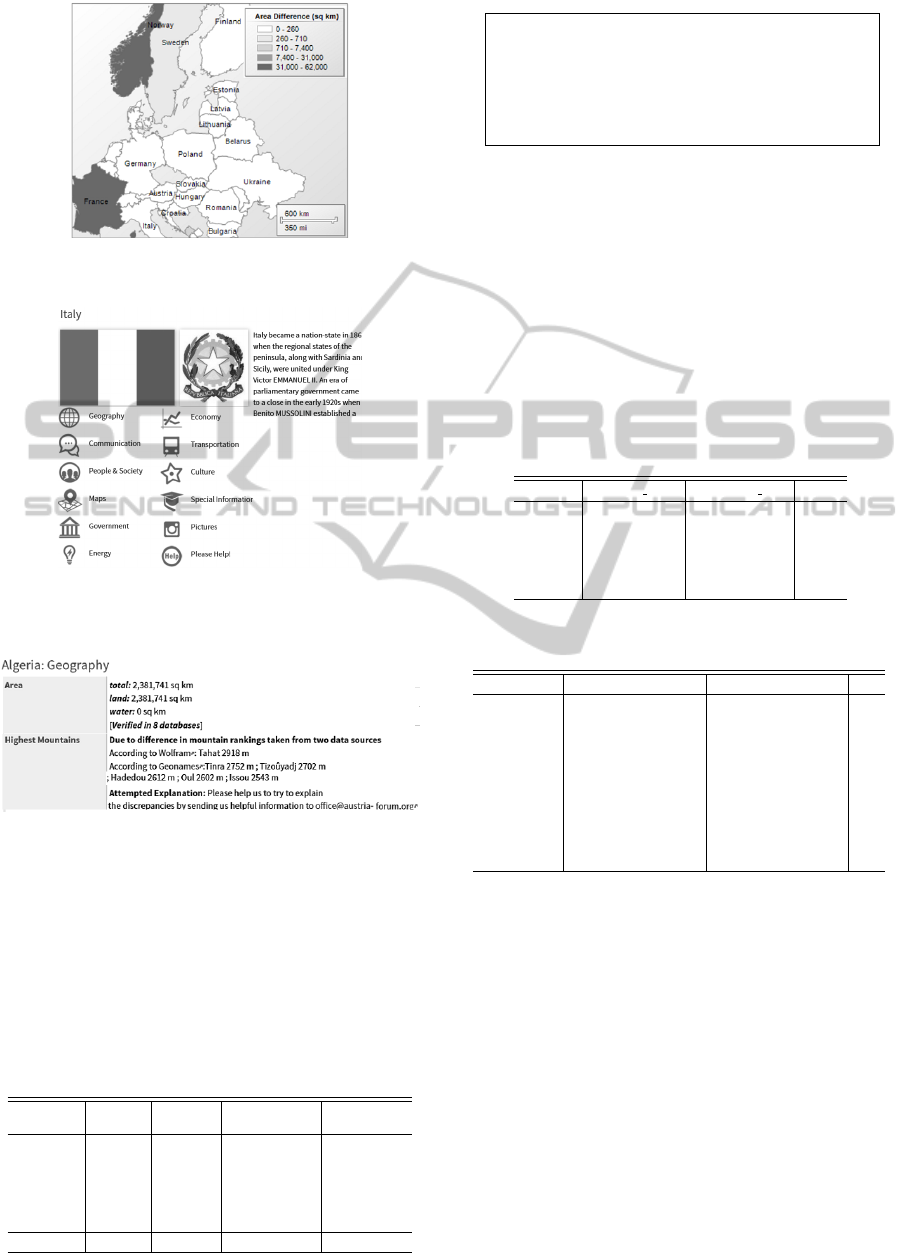
Figure 6: Map showing area difference of countries of Eu-
rope using data sources Cia World Factbook and DBpedia.
Figure 7: Main page of Italy in AF-Geo portal. It displays
flag, emblem, short description and icons. The icons lead to
sub-pages that contain details on related topics.
Figure 8: Algeria Geography section. When facts in multi-
ple data sources match we display [verified]. When facts
mismatch (different mountain rankings) we ask for help
from domain experts and community.
sible to find out why the numbers differ but in others,
this might be an impossible job. The variation of num-
bers depends also on the point in time and the defini-
tions involved makes all this a more than challenging
Table 2: Continent-wise city ranking verification results of
193 UN member states.
Continent Verified
Partially
Verified
Verified
+ Explanation
Not Verified
Europe 22 0 1 20
Africa 16 1 3 34
Australia 5 0 0 8
America 11 0 0 24
Asia 19 0 5 24
Total 73 1 9 110
1 select w . ci ty as Wolfram_city , g . c i t y as
Geonames_c i t y , g . ra n k a s Rank
2 fr o m Wolfr a m w j o i n isoc o d e s is o on
3 is o . co u n t ry =w . c o u n t r y join
4 Geo n a m e s g o n g . co u n t r y _c o d e =i so . iso
5 an d g . ra nk =w . r a n k w h e r e i s o . iso =BR
Listing 6: Using joins to get city ranks from both
tables Wolfram and Geonames based on ISO codes.
task that will never be fully completed. Further, when
we find identical figures we do indicate so, raising the
probability that the figures are correct. Similarly we
indicate where city and mountain rankings mismatch
and ask the domain experts for verification in case of
Not Verified rankings as shown in Figure 8.
We realize that this verification can only be suc-
cessful if we get help from many persons (domain ex-
perts, geographers and organizations).
Table 3: Different city rankings of Brazil found in Wolfra-
mAlpha and GeoNames.
Country Wolfram city GeoNames city Rank
Brazil Sao Paulo Sao Paulo 1
Brazil Rio de Janeiro Rio de Janeiro 2
Brazil Salvador Salvador 3
Brazil Brasilia Fortaleza 4
Brazil Fortaleza Belo Horizonte 5
Table 4: Highest mountains of some countries, Xshows
Verified case, X shows Not Verified case.
Country GeoName Wolfram
Albania Maja e Jezercs (2694) Golemi Korab (2764) X
Switzerland Dom (4545) Monte Rosa (4633) X
Germany Zugspitze (2962) Zugspitze (2962) X
France Mont Blanc (4810) Mont Blanc (4810) X
Montenegro Durmitor (2522) Deravica (2656) X
Macedonia Titov Vrv (2784) Golemi Korab (2764) X
Portugal Ponta do Pico (2351) Do Pico (2351) X
Serbia Dolni Kara (2100) Deravica (2656) X
Ukraine Hora Hoverla (2061) Goverla (2061) X
6 EVALUATION
The AF-Geo portal provides about 30,000 facts about
countries and territories. A sample is checked man-
ually for further reliability by Austria-Forum editors
and Quality Assurance analysts. It has approximately
7000 static pages displaying information about dif-
ferent aspects of countries. We present some quan-
titative measures as shown in Figure 9. The num-
ber 3510 against Geography comes from the follow-
ing procedure. We collected approximately (13) facts
such as land area, water area etc. for around 270
countries and territories. Therefore we are showing
(3510=270*13).
FactsCollectionandVerificationEfforts
149
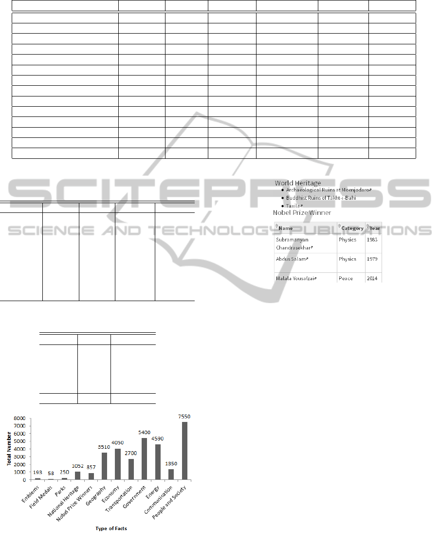
Table 7: Comparison of Facts and Features of AF-Geo portal with other geographic data sources.
Facts and Features Infoplease Factbook DBpedia
22
AF-Geo portal WorldAtlas Geonames
• Geography X X X X X X
• Economy X X X X X
• Transportation X X
• Government X X X X
• People and Society X X X X X
• Pictures X X X
• Energy X X
• Maps X X X X
• Heritage X
• Nobel prize winners X
• National parks X
• Facts validation X
• Virtual lab X
• Interactive visualizations X
Table 5: Total Area (sq km) of countries in different data
sources. For full list see, (Kulathuramaiyer et al., 2014).
Country Factbook DBpedia Infoplease Britannica
Philippines 300000 300001 300000 300000
Sri Lanka 65610 65610 65610 65610
Finland 338145 338242 338145 390903
Norway 323802 385183 324220 385186
France 643801 674843 547030 543965
Sweden 450295 449964 449964 447420
Austria 83871 83855 83870 83879
Belgium 30528 30528 30528 30528
Poland 312685 312602 312685 312679
Table 6: Continent-wise area verification results of 193 UN
member states.
Continent Verified Not Verified
Europe 30 13
Africa 35 19
Australia 7 6
America 20 15
Asia 22 26
Total 114 79
Figure 9: Facts Collection Summary.
Further, we present a comparison with other geo-
graphic data sources as mentioned in the Table 7. The
on demand exploration of data (countries compari-
Figure 10: Culture section of Pakistan in AF-Geo Portal.
son, top and bottom rankings of UN member states)
using virtual lab, interactive visualizations, and so-
phisticated reliability measures for validation of facts,
makes AF-Geo portal fairly unique.
Besides factual data, we have consolidated pic-
tures from different data sources. The current col-
lection contains approximately 20,000 pictures. The
culture section of each country is very significant. It
shows different aspects (heritage, national parks, dif-
ferent prize winner holders lists such as Wolf prize,
Abel prize, Turing award) all related to the culture of
a country. Figure 10 shows a sub-page that represents
aspects of the culture of Pakistan.
7 CONCLUSION AND FUTURE
WORK
The AF-Geo portal will hopefully succeed by provid-
ing reliable facts or at least it indicates those facts
that differ in different sources. Additionally, if users
want to explore a country, they have sufficient infor-
mation. We believe that this geographic web portal
can be valuable for large number of communities, par-
ticularly teachers, students or some tourists, who can
DATA2015-4thInternationalConferenceonDataManagementTechnologiesandApplications
150

use this for learning and understanding geography.
Overall, it is clear that verification of information is
an extremely important task. So far, very little has
been done towards measuring quality and reliability
of online information. However, reliability seems to
us is at most as important as just raw quality. We hope
to extend this verification to other quantitative facts in
the future.
REFERENCES
Bellahsene, Z., Bonifati, A., and Rahm, E., editors (2011).
Schema Matching and Mapping. Data-Centric Sys-
tems and Applications. Springer.
Bernstein, P. A., Madhavan, J., and Rahm, E. (2011).
Generic schema matching, ten years later. PVLDB,
4(11):695–701.
Calzada, G. and Dekhtyar, A. (2010). On measuring the
quality of wikipedia articles. In Proceeding WICOW
10 Proceedings of the 4th workshop on Information
credibility, pages 11–18.
Carlo Batini, M. S. (2006). Data Quality Concepts,
Methodologies and Techniques (Data-Centric Systems
and Applications). Springer, USA.
Carlson, A., Betteridge, J., Kisiel, B., Settles, B., Jr., E.
R. H., and Mitchell, T. M. (2010). Toward an archi-
tecture for never-ending language learning. In Pro-
ceedings of the Twenty-Fourth Conference on Artifi-
cial Intelligence (AAAI 2010).
Dalip, D. H., Cristo, M., and Calado, P. (2009). Automatic
quality assessment of content created collaboratively
by web communities: A case study of wikipedia. In
Proceedings of the 9th ACM/IEEE-CS joint confer-
ence on Digital libraries, pages 295–304.
Kulathuramaiyer, N., Maurer, H., and Mehmood, R. (2014).
Some aspects of the reliability of information on the
web. JUCS, 20(9):1284–1305.
Mehmood, R. (2014). Geographic data verificaiton. IPSI,
10(2):20–25.
Rahm, E. and Bernstein, P. A. (2001). A survey of ap-
proaches to automatic schema matching. VLDB,
10:334–350.
Suchanek, F. M., Sozio, M., and Weikum, G. (2009). Sofie:
A self-organizing framework for information extrac-
tion. In In Proceedings of WWW, pages 631–640.
Weikum, G. and Theobald., M. (2010). From information to
knowledge: harvesting entities and relationships from
web sources. In In Proceedings of PODS, pages 65–
76.
Wurzinger, G. (2010). Information consolidation in large
bodies of information. JUCS, 16(21):3314–3323.
Zhao, S. and Betz, J. (2007). Corroborate and learn facts
from the web. In Proceedings of the 13th ACM
SIGKDD international conference on Knowledge dis-
covery and data mining, pages 995–1003.
FactsCollectionandVerificationEfforts
151
