
A Study on the Usage of Smartphone Apps in Fire Scenarios
Comparison between GDACSmobile and SmartRescue Apps
Parvaneh Sarshar, Vimala Nunavath and Jaziar Radianti
Centre for Integrated Emergency Management (CIEM), University of Agder, Grimstad, Norway
Keywords: Smartphone Sensors, Smartphone App, Twitter, Threat Mapping Tools, Fire.
Abstract: In this paper, we present a thorough overview of the two recently developed applications in the field of
emergency management. The applications titled GDACSmobile and SmartRescue are using mobile app and
smartphone sensors as the main functionality respectively. Furthermore, we argue the differences and
similarities of both applications and highlight their strengths and weaknesses. Finally, a critical scenario for
fire emergency in a music festival is designed and the applicability of the features of each application in
supporting the emergency management procedure is discussed. It is also argued how the aforementioned
applications can support each other during emergencies and what the potential collaboration between them
can be.
1 INTRODUCTION
By looking at the news or crisis mapping tools such
as Ushahidi (Ushahidi, 2014), Twitcident
(Twitcident, 2014), and Crisis Tracker (Tracker,
2014), this fact can be understood that crises are
happening all around the world every day or even
every hour. These crises or disasters can be man-
made or natural. They can have impact on a limited
area, national, regional, or international level. The
aforementioned tools and many other existing
applications developed in different countries prove
the fact that the power of information technology is
vastly assisting societies to prevent and handle
disasters in the best possible way. An example is the
vast use of Ushahidi platform in emergencies such
as Haiti earthquake in 2010 and the attacks on
Westgate Mall in Nairobi in 2014.
Mapping the hazard, getting an overview of what
is happening during and after a disaster, and
communication possibility among rescuers and
victims are the most challenging and critical tasks in
emergency management. Using smartphones and
their newest technologies in one hand and using
social media such as Twitter or Facebook on the
other hand, have become the most practical sources
and solutions to overcome these challenges.
For collecting desirable information and enabling
a timely emergency management response,
smartphones and their embedded sensors including,
but not limited to accelerometer, gyroscope,
barometer, humidity, and GPS have become
extremely popular. Besides, social media is also one
of the most common sources for real-time data from
disaster-affected areas to disaster managers (Link et
al., 2013). Among many social media sources,
Twitter became a frontline candidate because of its
status of being a “what’s-happening-right-now”-tool
(Bifet and Frank, 2010). These systems are used to
reduce uncertainty caused by disasters.
In this paper, we focus on two crises
management tools that authors had worked closely
with during their research, i.e. GDACSmobile
(GDACSmobile, 2014) and SmartRescue application
(SmartRescue, 2014). The former is an information
system that acts as a real-time multi-hazard platform
using smartphones and Twitter. The latter is an
application for both monitoring hazard
developments and tracking victims during a disaster
applying smartphone sensors and ad-hoc
networking. The reason for selecting these two apps
is that the authors had the opportunity to employ
them both in their research and in a serious
emergency game designed by ISCRAM summer
school. This paper reviews both platforms in details
and compares their functionalities and features and
at last investigates potential collaboration of these
two platforms within a designed scenario.
The remainder of this paper is structured as
follows. Section 2 describes the literature review.
469
Sarshar P., Nunavath V. and Radianti J..
A Study on the Usage of Smartphone Apps in Fire Scenarios - Comparison between GDACSmobile and SmartRescue Apps.
DOI: 10.5220/0005466304690474
In Proceedings of the 17th International Conference on Enterprise Information Systems (ICEIS-2015), pages 469-474
ISBN: 978-989-758-097-0
Copyright
c
2015 SCITEPRESS (Science and Technology Publications, Lda.)

Section 3 explains the two selected applications in
details. In Section 4, the role of these apps in two
emergency scenarios will be studied. Section 5
concludes the paper.
2 LITERATURE REVIEW
By the concern of disasters and the rapid
improvements in technologies, governments of
nations around the world are concentrating
significantly on the use of different technologies in
all aspects and phases of emergency management.
Even though, most of the disasters have impact on a
limited area or are in national level, other countries
especially neighbouring ones involve in the
emergency management activities.
A recent example of this motto is the cooperation
of 26 nations in the massive international search for
the Malaysia Airlines jetliner MH370 that
disappeared on March 8 with 239 people on board in
2014. Therefore, most of the systems, platforms, or
applications developed in order to be applied in
disasters can cover a wide scale of an area. These
systems involve many countries from different
continents while there are some other systems that
cover only a limited area such as a building.
There are hundreds of platforms with almost the
same goals and concepts available in the market
now. A literature review on some currently available
emergency management platforms and tools is
discussed in this section. These tools are carefully
selected as they are the most related tools to our case
studies.
In (Radianti et al., 2014) some of these
emergency management platforms have been
discussed and compared in details. About 16
Disaster and Crisis Apps for iPhone and iPad are
also reviewed in (MissionMode, 2014). There is a
long list of applications and projects with the
concept of emergency management. These projects
are such as DC HSEMA (DC.gov, 2014), FEMA
(FEMA, 2014), ArcGIS for Emergency Management
(ESRI, 2014). Besides, there are many researches
(see, e.g., (Boloni et al., 2006; Lee et al., 2011; Tao
et al., 2013)) on the best possible approaches such as
agent-based, cloud computing, and GIS-based for
developing disaster response applications.
As can be seen, most of these platforms function
entirely or partly only when the Internet is available.
Besides, some of them are able to cover just a
limited area during a disaster. Therefore, the author
chose two other useful applications to study and
investigate in the next section. The first one is
GDACSmobile and it is chosen as it covers disasters
all around the world but is still reliable on Internet
connection. The second one is SmartRescue
application that it is working in the idea of ad-hoc
networking (not yet implemented) but covers
disasters happening in limited areas. In this paper, it
is tried to investigate the possible collaboration of
these two systems with their unique abilities for
gaining the best possible solution in emergency
management.
3 STUDIED APPLICATIONS
In this section, we study the two selected emergency
management tools. Later in this section, we
summarize the differences and similarities of both
applications and their strengths and weaknesses in
Table 1.
3.1 GDACSmobile
The GDACSmobile project is a collaborative work
between the Information Systems Department of the
University of Münster and the Joint Research Centre
(JRC) of the European Commission with the aim to
expand GDACS by community involvement.
The goals of GDACSmobile project are;
increasing the quality of disseminated information
using smartphone apps and Twitter, decreasing the
uncertainty of the information received from Twitter
using bounded-crowdsourcing, and using
smartphones for information exchange/sharing and
coordination support in the first phase after a major
sudden-onset disaster.
To accomplish these goals, the GDACSmobile
team implemented a mobile phone client application.
The client app, primarily used for accessing content
and sharing/updating information, is supported by a
server application which is responsible for data
retrieval, storage and analysis.
The resulting solution, “GDACSmobile” enables
disaster management professionals and the affected
population to share their observations from the
affected area as “situation reports”, both via the
GDACSmobile client application for mobile
devices, and via Twitter. Via the client application,
professionals and population can also receive
situation reports that provide valuable information to
their decision-making. GDACSmobile has been
developed both as an application on smartphones
and as a web-based application.
The GDACSmobile target groups, i.e. disaster
management professionals (“authorized users”) and
ICEIS2015-17thInternationalConferenceonEnterpriseInformationSystems
470
affected population (“public users” or can be
“authorized users”), share their observations from
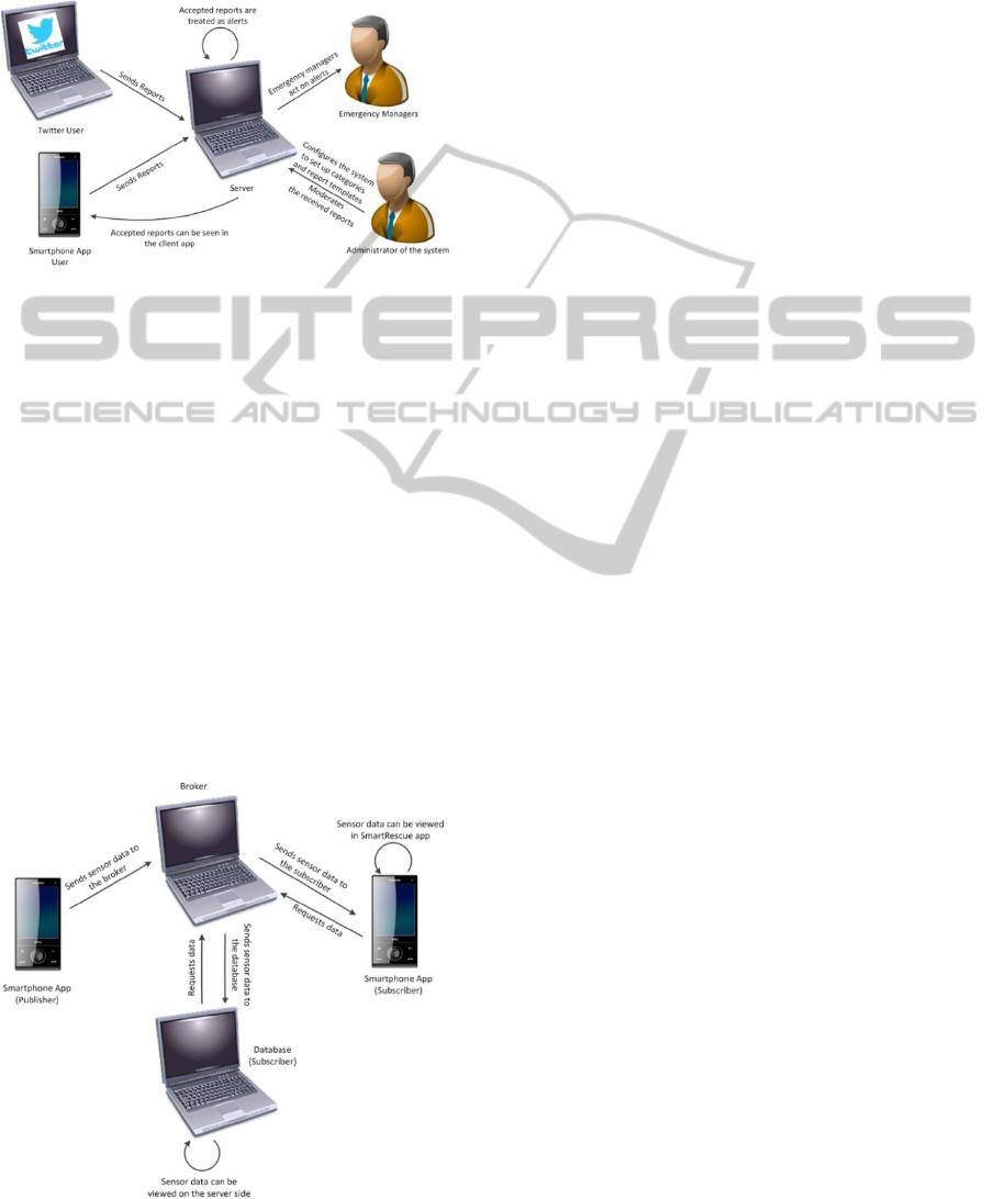
the disaster-affected area. Figure 1 shows how the
information flow is handled in GDACSmobile
system.
Figure 1: Simplified workflow of GDACSmobile.
3.2 SmartRescue
It has been developed in the Centre for Integrated
Emergency Management (CIEM, 2015) at the
Universitetet i Agder (UiA). The main idea of the
SmartRescue is to use smartphone technology for
assisting in a crisis, particularly in the acute phase,
when victims are left to themselves but still need
help, while delays occur in the evacuation process.
The SmartRescue project has several goals
including but limited to: detecting and predicting
hazard using advanced sensors in newer
smartphones to help crisis managers and the public
in acute crisis situations, mapping the threats and
helping people in the evacuation process,
constructing risk-minimizing evacuation plans,
hindering congestion, and avoiding threats.
Figure 2: Simplified workflow of SmartRescue.
To achieve aforementioned goals of this project,
a novel smartphone-based communication
framework using machine learning techniques is
proposed that intelligently process sensor readings
into useful information for the crisis responders.
Core to the framework is a robust content-based
publish-subscribe mechanism that allows flexible
sharing of sensor data and computation results.
Figure 2 shows how the information flow is handled
in SmartRescue system.
3.3 Comparison
Table 1 presents the similarities and differences of
these two applications and highlights the strengths
and weaknesses of both apps.
4 SmartRescue AND GDACSmobile
IN PRACTICE
In this section, an emergency scenario is defined.
This scenario is a fire happening in an open-area
music festival with more than 3000 participants. The
aim of having this scenario is to investigate how the
aforementioned apps can work in practice and
collaborate with each other in potential disasters.
4.1 Defining the Scenario: Fire in a
Music Festival
Few participants of the music festival have noted the
fire in the corner of the music festival location. They
have called the emergency service (110) and
informed them about the fire. Fire responders note
down the information regarding callers’ ID, location,
and the emergency type. Based on the received
information, fire responder alerts other emergency
services like police and ambulance staff and decides
how many staff and resources have to go to the
emergency location. When the fire service
responders arrive at the scene, first they try to find
out the fire location, its condition, and number of
victims. If they find out that there are any
participants trapped in or near the fire, they try to
evacuate them. If the fire is steadily spreading over
the other parts of the site and is difficult to
extinguish, then the fire responders consider this
incident as an emergency and ask other fire
responders to join and assist them in extinguishing
fire and evacuating people. Emergency responders
from other services like police and ambulance staff
will also reach the site.
AStudyontheUsageofSmartphoneAppsinFireScenarios-ComparisonbetweenGDACSmobileandSmartRescueApps
471
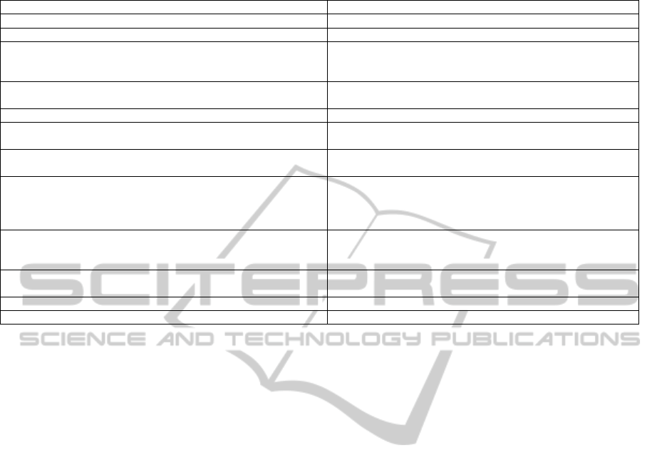
Table 1: A comparison between GDACSmobile and SmartRescue apps.
GDACSmobile SmartRescue
Planned for weeks after the disaster Planned for first hours after the disaster
Has a smartphone application and a web-based server Has a smartphone application and a web-based server
Stores data in the phone when it is offline and transfers data to the
server when it is online.
The publisher loses the data when network connection is not
available. Broker buffers data in the phone/server when it is
offline and transfers data to the subscriber when it is online.
It is for large-scale disasters
e.g. for national or international level
It is for small-scale disasters
e.g. inside building, ships or limited areas
Uses bounded-crowdsourcing (Meier, 2013) for data collection Uses crowdsourcing for data collection
Uses tweets, registered users, and public users for bounded-
crowdsourcing
Uses sensors for crowdsourcing
Helps and supports decision making of the disaster managers,
rescue members, and victims
Helps and supports decision making of the disaster managers,
rescue members, and victims
The smartphone app (client app) needs human-computer (phone)
interactions as smartphone users should use the app for reporting.
The smartphone app requires very limited human-computer
(phone) interactions, users only need to turn on the “Wi-Fi” and
choose to be a “subscriber” and/or a “publisher” by a simple
click.
In the smartphone app, the user can be an authorized (registered)
user or a public user. Public users do not have access to all the
features available on the client app.
In the smartphone app, there is no registration needed, everyone
who has installed the app can use all the features of the app.
In the web-based server, the user can be either an admin or a
registered user.
In the web-based server, the admin has the control of the
systems.
Supports iOS and Android operating systems. Supports Android operating systems.
The smartphone app needs the Internet connection only. The smartphone app works with any wireless networks.
After their arrival, police is in charge of the
location and the site. Police acts as the commander
at the site and he takes all the decisions. Police will
make sure that all risk areas of the site are accessible
by emergency vehicles. They implement plans to
remove vehicles blocking emergency routes. Police
will appoint an on-scene commander to
communicate with the command and control room.
In command and control room, a group from all
emergency response organizations such as police,
fire, ambulance, media, priest, and mayor will be
formed to take decisions at off-site. Command and
control room will get the required information from
the on-scene commander about the situation at the
site. Participants of the festival will be evacuated by
emergency responders. Ambulance service
emergency responders help participants who are
suffering with semi or full burns. They apply the
first aid and shift them to the nearest hospital for the
further treatments and then report the cases. If any
deaths are noticed by participants they inform to the
emergency responders.
4.2 Utilizing GDACSmobile in the
Scenario
As mentioned earlier, the GDACSmobile app can be
used by both emergency management professionals
as well as participants for reporting emergency
situation and collecting information (via text and
image) both in offline and online mode. In the above
described scenario, all the participants can report
and collect data using the client app or Twitter. The
detailed description of the employment of the
GDACSmobile app is described for both emergency
site as well as coordination (command and control
room) centre.
4.2.1 Employing GDACSmobile at the
Emergency Site
A public user means nothing but participants of the
music festival. When the participants of the music
festival or other people near by the music festival
note that there is a fire emergency, they can start
using GDACSmobile app or their Twitter account to
report about the emergency situation by sending
messages with text and image. For example, they
can share their location in the emergency site with
directions in form of text or else they could take the
picture of the location. This information is received
by the emergency responders in order to help the
victims. When participants use the app, they can
send message as public users to get help or to report
about the situation. It is worth mentioning that by
using tweets for information sharing, they have to
use hash-tags. These hash-tags are used for
categorizing the information, for example, location
of the fire, logistics needed for helping the people,
and so on. Victims of the emergency can view the
other submitted reports as a list or on the map when
the administrator makes the reports available. With
the available reports, participants as well as
emergency responders can get the overview of the
ICEIS2015-17thInternationalConferenceonEnterpriseInformationSystems
472

situation by viewing the map. Reports coming from
authorized (registered) users are accepted by default.
These reports are used for evacuating and helping
the victims of the music festival.
4.2.2 Employing GDACSmobile at the
On-scene Coordination Centre
When the reports are submitted by both participants
and emergency responders through GDACSmobile
app or through Twitter, administrator (on-scene
commander) views and moderates the reports
(public accept, accept, reject, and not evaluated).
Alerts are appointed to any accepted reports. So the
on-scene commander uses these alerts to assign the
tasks to the corresponding responders. Authorized
users can send messages like “where they are and
what they need for what”. Administrator can have
the chance to add extra information such as
description and comment on the available reports.
By using GDACSmobile app, emergency responders
can use the emergency related data to get the
overview of the situation as well as to help the
victims by alerting the public via Twitter or the
client app.
4.3 Utilizing SmartRescue in the
Scenario
As mentioned earlier, the SmartRescue app can be
used by both emergency management professionals
and participants. This app is mainly used for
publishing to and subscribing for the information
and getting overview of the emergency situation. In
the described scenario, all the participants and
emergency responders can report and collect data by
using the smartphone app. The detailed description
of the app usage is described for both the emergency
site and the coordination centre.
4.3.1 Employing SmartRescue at the
Emergency Site
In order to use this app, participants of the music
festival should have this app installed in their
smartphones before the festival starts. So they can
send the information to the emergency responders
when the fire happens. When fire is noticed and
informed, emergency responders will go to the
emergency site. Right after reaching the site,
emergency responders start using the SmartRescue
app. Either emergency responders, firefighter,
police, or health staff can act as either publisher (to
send information) or subscriber (to receive
information). When participants act as publisher,
they publish data gathered from sensors.
This published data is available for the
responders as subscribers. Using the smartphone
sensors of the people inside the fire location, the app
can deduce how close they are to the fire and how is
the status of the fire nearby them. They will also
know if the participant is moving or not, or they can
check the humidity and the pressure of that area by
the data publishing from the smartphone sensors.
This generates a global or a local picture of the fire.
Using this picture, the app can also predict how the
fire is going to develop in the near future using
Bayesian networks approach. This supports
firefighters in making decisions and plans about
extinguishing fire, evacuation routes and so on.
4.3.2 Employing SmartRescue at the
On-scene Coordination Centre
At on-site coordination center, on-site commander
will be in lead. SmartRescue mobile app will be
used by him in order to get the overview of the
emergency situation. When the participants and
emergency responders in the scene act as publishers,
then the on-scene commander can receive the
published information. Based on the publishers’
mobile phone sensors, on-scene commander can
know the position of the victims and rescuers
(firefighters) as well as the severity of the fire. The
received information and the ability of SmartRescue
app in predicting fire condition will support him/her
in making decisions. They can also make required
decisions easier in the on-scene coordination center
while they can get the overview of the situation real-
time and with no extra intermediate.
4.4 Possible Collaboration
As mentioned above, GDACSmobile works with the
Twitter and smartphone app and the other one,
SmartRescue, works with smartphone app and its
embedded sensors. GDACSmobile is for reporting
and receiving the emergency information while
SmartRescue is not only for reporting and receiving
emergency information but also for predicting the
growth of the fire.
In our designed scenario, fire in a music festival,
the felexibility of SmartRescue and its ability to
work with the least possible human-interaction
comparing to GDACSmobile app can significantly
help participants trapped, injured, or suffering from
panic attack, as they do not have to be engaged with
their smartphones. On the other hand, the reporting
system in GDACSmobile allows users to send
detailed reports about different catagories such as
AStudyontheUsageofSmartphoneAppsinFireScenarios-ComparisonbetweenGDACSmobileandSmartRescueApps
473

health, logistics, and food using text and image.
Participants can send images of the situation with
their location to the server.
Social media is another aspect that is not covered
in SmartRescue, so it can be supported through
GDACSmobile. Participants can tweet their situation
or what they have witnessed during the emergency.
This information can be used by emergency
responers during the emergency or after that.
If both apps collaborate, then the emergencies
will be handled very efficiently as both social media
and sensors can be used for threat mapping. Besides,
interaction and communication between those that
are involved in the crises will be done faster and
smoother if both applications are integrated. This
allows a better understanding of the situation and a
more efficient reaction to crises due to the
integration of an intelligent system that achieves
information from smartphones and social media.
5 CONCLUSIONS
This paper studied two emergency management
tools that are developed in two universities in
Norway and Germany. The information and work
flow of the apps and a comprehensive comparison of
the features of them were presented. Then the role of
the apps in a proposed emergency scenario was
discussed. Finally the potential collaboration of the
apps in an emergency situation was argued. It is
proposed to use both systems in drills and games to
study the potential collaboration between them and
how they can support each other during a real crisis.
This also helps the developers to improve the
weaknesses and lacks of both apps.
ACKNOWLEDGEMENTS
The research reported here has been partially funded
by the research grant awarded to the SmartRescue
project by Aust-Agder Utvikling- og
Kompetansefond. Thanks to Daniel Link and
GDACSmobile group for their cooperation and
supports.
REFERENCES
Bifet, A. & Frank, E. 2010. Sentiment knowledge
discovery in twitter streaming data. Proceedings of the
13th International Conference on Discovery Science.
Canberra, Australia: Springer-Verlag.
Boloni, L., Khan, M. A. & Turgut, D. Agent-based
coalition formation in disaster response applications.
Distributed Intelligent Systems: Collective
Intelligence and Its Applications, 2006. DIS 2006.
IEEE Workshop on, 2006. IEEE, 259-264.
Ciem. 2015. Centre for Integrated Emergency
Management [Online]. Norway: University of Agder.
Available: http://ciem.uia.no/.
Dc.Gov. 2014. DC Homeland Security and Emergency
Management Agency [Online]. Washington DC, USA.
Available: http://hsema.dc.gov/.
Esri. 2014. ArcGIS for Emergency Management [Online].
Available: http://solutions.arcgis.com/emergency-
management/.
Fema. 2014. Federal Emergency Management Agency
[Online]. Available: http://www.fema.gov/.
Gdacsmobile. 2014. GDACSmobile [Online]. Germany.
Available: http://emm-labs.jrc.it/iOSEnterprise/
GDACS/.
Lee, J., Niko, D. L., Hwang, H., Park, M. & Kim, C. A
GIS-based Design for a Smartphone Disaster
Information Service Application. Computers,
Networks, Systems and Industrial Engineering (CNSI),
2011 First ACIS/JNU International Conference on,
2011. IEEE, 338-341.
Link, D., Hellingrath, B. & De Groeve, T. 2013. Twitter
Integration and Content Moderation in
GDACSmobile. 10th International ISCRAM
Conference, 2013 Baden-Baden, Germany. 67-71.
Meier, P. 2013. iRevolution [Online]. Available:
http://irevolution.net/2011/12/07/why-bounded-
crowdsourcing/.
Missionmode. 2014. 15 Disaster and Crisis Apps for
iPhone and iPad [Online]. North America Mission
Mode. Available: http://blog.missionmode.com/blog/
15-disaster-and-crisis-apps-for-iphone-and-ipad. html.
Radianti, J., Gonzalez, J. J. & Granmo, O.-C. 2014.
Publish-subscribe smartphone sensing platform for the
acute phase of a Disaster: a framework for emergency
Management support. PerNeM (The 4th International
Workshop on Pervasive Networks for Emergency
Management). Budapest: IEEE.
SmartRescue. 2014. SmartRescue Application [Online].
Norway: Universitet i Agder. Available:
http://ciem.uia.no/project/smartrescue.
Tao, L., Fan, Y. & Wang, X. Research on the application
in disaster reduction for using cloud computing
technology. Third International Conference on
Photonics and Image in Agriculture Engineering
(PIAGENG 2013), 2013. International Society for
Optics and Photonics, 876209-876209-5.
Tracker, L. C. 2014. LRA Crisis Tracker [Online]. USA.
Available: http://www.lracrisistracker.com/ .
Twitcident. 2014. Twitcident [Online]. Netherlands.
Available: http://twitcident.com/.
Ushahidi. 2014. Ushahidi [Online]. Available:
http://ushahidi.com/.
ICEIS2015-17thInternationalConferenceonEnterpriseInformationSystems
474
