
COP-VW: Cone-over-Projection Directional Model Viewer
Jefferson Amaral da Silva
1
and Karla Donato Fook
2
1
State University of Maranhão (UEMA)
São Luis-MA, Brazil
2
Department of Informatics, Federal Institute of Education, Science and Technology of Maranhão (IFMA),
São Luís-MA, Brazil
Keywords: Directional Relationships, Geometric Algorithms, Geographic Information Systems, COP-Model, COP-
VW.
Abstract: An important feature for geographic systems is to identify directional relationships between objects stored
in Spatial Database Management Systems (SDMS). This feature is used with other information type, such as
Metric and Topological Relationships. This features group provides relative positioning between
Geographical Objects in some direction, and supports decision makers job, such as to decide where setting
up certain buildings, opening of access roads, and installation of transmission towers, for instance. Some
approaches addresses to direction definition, but without implementation. Cone-Over-Projection Directional
Model (COP Model) refines directions definition and enhances spatial queries accuracy in a significant
form. The Model has a computational tool to support its application. This work presents the COP Model
implementation through COP Viewer (COP-VW) application that uses Geometric Algorithms added to an
SDMS located in a Web Server. Several users can access COP Model resources at different geographical
locations, and different geodatabases can be available to environmental and urban planning decisions. This
is a first step to migrate COP Model to mobile platform.
1 INTRODUCTION
The identification of Directional Relationships
between objects stored in Spatial Database
Management Systems (SDMS) can set a useful
source of information. This feature combined with
other, such as Metric and Topological Relationships
supports urban planning job. Decision-makers use
this features to decide where to make buildings, to
open access roads, and to install transmission
towers, for example. In these cases, is fundamental
to know the relative positioning between
Geographical Objects in a given direction.
Depending on the application domain, some
spatial relations may be more significant than
others (Papadias and
Theodoridis, 1997).
Topological relationships have a set of definitions
and operations widely accepted (Egenhofer et al.,
1991; Egenhofer and Franzosa, 1995). There’s no
unified Directional Relationships concept. This point
is a problem and causes different approaches to
define directions, each with its positive and negative
points (Theodoridis et al., 1996).
As result, several models define the directional
relationships, each one with their own
characteristics. Researchers present Models in
different implementation. Silva and Fook (2013)
propose Cone-Over-Projection Directional Model
(COP Model) to refine direction definitions. COP
Model is a hybrid model that includes characteristics
of the models based on Cone (Peuquet and Zhan,
1987) and Projection (Frank, 1992).
We highlight that the COP Model enhances
spatial queries accuracy in a significant form, and
aims to support decision makers in their resource
management activities. This paper presents COP-
VW, the computational tool that supports COP
Model use. This software uses a Geodatabase hosted
in a Web Server. This Geodatabase allows free
access to information which supports decisions
concerned to environmental and urban planning. In
this case, makers’ decisions can visualize several
databases in different places around the world. There
is a proposal to upgrade this Geodatabase to Mobile
platform.
Next section presents directional relationships
between objects approaches, and the COP Model
245
Amaral da Silva J. and Donato Fook K..
COP-VW: Cone-over-Projection Directional Model Viewer.
DOI: 10.5220/0005449602450252
In Proceedings of the 11th International Conference on Web Information Systems and Technologies (WEBIST-2015), pages 245-252
ISBN: 978-989-758-106-9
Copyright
c
2015 SCITEPRESS (Science and Technology Publications, Lda.)
adds. Section 3 presents COP Model and their
characteristics. Section 4 presents COP Viewer
specification, application, results and discuss about
COP Model use. Finally, Section 5 presents some
conclusions about the geographical application.
2 RELATED WORK
Authors propose directional relationships between
objects approaches. There are two categories which
include basic models for defining directional
relationships: Cone-Based Models and Projection-
Based Models (Xia et al., 2007).
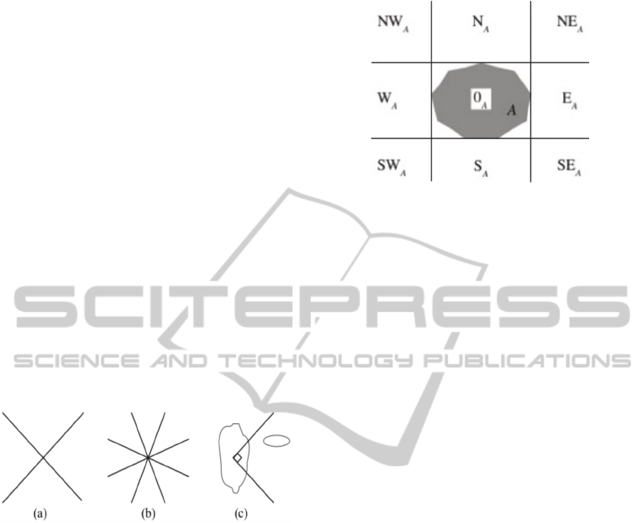
The Cone-Based Models partition the space by
using lines with an origin angle α (Figure 1). Typical
models include the 4-direction Model, Figure 1(a),
the 8-direction model, Figure 1(b), and the triangle
model, Figure 1(c) (Tang et al., 2008). These
Models provide an accurate identification of
directional relationships for point geometries.
However, misleading directional relations may be
produced when reference objects are lines or
polygons (Tang et al. 2008).
Figure 1: Cone-Based Model.
The Projection-Based Models divide space by using
lines parallel to the axes (Spiros et al., 2007). The
space around an object reference A is partitioned
into nine areas:
north (NA)
northeast (NEA)
east (EA)
southeast (SEA)
south (SA)
southwest (SWA)
west (WA)
northwest (NWA)
These areas refer to the cardinal and ordinal
directions. There is one extra region corresponding
to the Minimum Bounding Rectangle (MBR) of the
reference geometry (0A), as shown in Figure 2. In
this category, the MBR Model is prominent (Tang et
al., 2008).
Figure 2: Projection-Based Model.
At first, Egenhofer et al. (2000) introduced a
Minimum Bounding Rectangles (MBR) Model,
which uses the 4-intersection matrix, projecting a
grid over the concerned geometries (Egenhofer and
Herring 1991). This Model expresses directional
relationships between the MBR of the reference
object A and the primary object B. It considers A
(interior and boundary), and B (interior and
boundary). Later, authors extended the model to 9-
intersection matrix. Now the approach considers
interior, boundary and exterior of A and B objects
(Egenhofer and Herring 1991). Minimum Bounding
Rectangles Model is not suitable for treating points,
since they do not actually have MBR. Besides,
Egenhofer work was theoretical, not presenting
implementation.
Zhu et al. (2012) presents a model for defining
directional relationships between geometries based
on Geo-Ontologies. In this model, secondary queries
made on Geo-Ontologies settle the directional
relationships. The Zhu's model adds semantics to the
research and enables tapping knowledge about the
directionality in the objects represented in the
ontology. However, this addition implies data
arranged in the form of ontological basis on the
studied area, and could result in spatial databases
becoming incompatible with this model, if there is
no ontology regarding their spatial context. Further,
the ontological database is external to the SDMS,
resulting in the need for two databases, one spatial
and one ontological, separated to perform the search.
Thus, integration with the existing SDMS resources
becomes problematic and complex. In this work, the
model is theoretical, and the implementation will be
treated as a future work. Next presents COP-Model,
which aims to improve the accuracy of spatial
queries significantly.
WEBIST2015-11thInternationalConferenceonWebInformationSystemsandTechnologies
246
3 COP-MODEL
Cone-Over-Projection Directional Model is a model
for defining directional relationships between two
geometries. For this, the model uses the union and
adaptation of two models: 8 Directions Cone-Based
Model and MBR Model (Projection-Based)
introduced by Egenhofer et al. (2000).
COP Model simulates the human view angle,
starting from a central point and grows as it moves
away from the source with the ability to treat line
and polygon geometries from Egenhofer model
(2000).
The model developed core was overlapping the
grid projection with the conical grid to identify areas
where they differ. This feature reduces the gap
between sizes of existing partitions on the projection
model. The union of cone and projection models
uses concepts and algorithms from computational
geometry, and processes how objects relate to each
other and with the regions defined by the designed
model. COP Model improves significantly the
accuracy of spatial queries. This feature is essential
to support the territorial planning applications.
Da Slva and Fook (2013) developed a pseudo-
implementation of COP Model. This pseudo
implementation is generic and allows to be
translated into various programming languages and
in third-party application or database. These features
were incorporated to SDMS. Developers can use this
module as standalone software or as an extension of
some existing Geographical Information System
(GIS) as gvSIG, Kosmo GIS or QGIS. This
implementation allows you to check the COP Model
application and is a differential feature over others
approaches.
Next section presents COP-VW, a Geographical
Information System developed as a COP Model
concept proof.
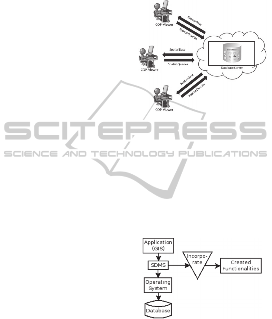
4 COP-VW
COP Viewer or COP-VW is software that allows
COP Model application. Their architecture contains
a Database Server. Several users in different
geographical locations can access Geodatabase
through Web to make spatial queries using COP-
VW (Figure 3). The GIS allows that different
decisions to be made for different territorial
purposes more precisely. For example, select area to
environmental protection or build factories or
hospitals.
Figure 3: COP-VW Architecture.
We used the Java programming language, Sun Java
Windowing (SWING) and Java 2D Graphics API
(Java 2D) as follows:
Java APIs such as Java Database Connectivity
(JDBC) to connect with SDMS
SWING to create the GUI
Java 2D for graphic display of retrieved
information from SDMS
There are several ways to implement new
functionalities at Spatial Queries. We implement
COP Model features as SDMS extensions from their
source code. Geographical Information Systems
only need to invoke operations aggregated to the
database to use COP Model features (Figure 4). We
stress this point as strong feature of work.
Figure 4: COP Model extensions insertion layer (Silva and
Fook, 2013).
Spatial queries can unite topology and distance
concepts with directionality concepts on the same
database. COP-VW uses data structures of
standardized SF-SQL hierarchy by OGC.
COP-VW:Cone-over-ProjectionDirectionalModelViewer
247
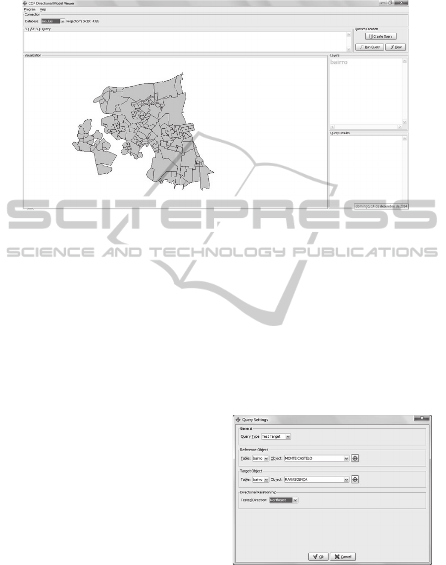
Figure 5: COP-VW main Form.
4.1 Specification
COP-VW works object concepts from COP Model.
For this, we created classes to represent the
information brought from SDMS. These classes
were generated internally in the COP-VW. The
model has two classes, and the spatial reasoning
complexity was abstracted. We use standard Java
programming language API and API provided by
PostgreSQL/PostGIS.
The GIS includes resources to handle geospatial
entities, objects and geometries, as well as a
Descriptor Table. COP-VW uses SDMS and COP
Model functionalities. There is not spatial processing
functionality in it.
4.2 Implementation
COP-VW releases user to write SQL queries/SF-
SQL directly. There are Forms to generate spatial
queries visually. Figure 5 shows the main COP-VW
Form. There are several parts in this Form: Figure 5
(a) displays information about the database
connection and projection used by the geometries.
Figure 5(b) displays the spatial query produced by
the tool. In Figure 5(c) there are creation and submit
queries buttons. Figure 5(d) shows spatial layers
presented in the open database. Figure 5(e) has
graphical representation of the loaded geometries
from database and results of spatial queries
submitted. Finally, Figure 5(f) we see textual details
recovered from spatial queries.
The display panel of the geometries shown in
Figure 5(e) provides translational and scale features
of the displayed geometry. This allows a better
evaluation of the consultations results.
User can create Spatial Queries in a COP-VW
Form (Figure 6). There are two different categories
of queries available: “Test Target” and “Find
Target”.
To perform “Test Target” type queries, user must
inform: Reference Object, Target Object, and any
direction of the COP Model. After that, COP Model
implementation calculates the percentage of the
area/length of Object Target in the direction
informed towards the Reference Object.
Figures 6 and 7 show the Form for this query
creation and its result, respectively.
Figure 6: COP-VW “Test Target” query Form.
The COP-VW Query Text produced in Figure 6 is a
SF-SQL: SELECT
A
B C
D
E
F
WEBIST2015-11thInternationalConferenceonWebInformationSystemsandTechnologies
248
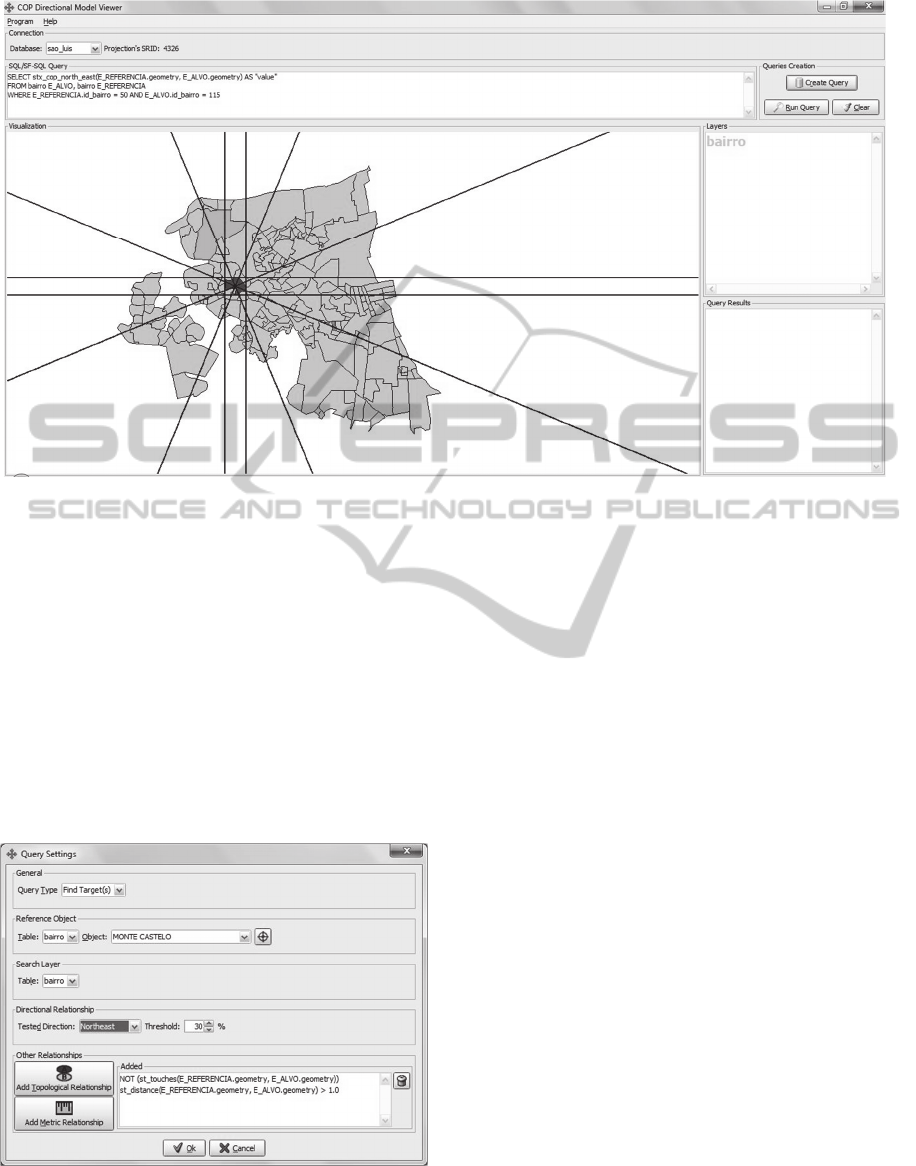
Figure 7: COP-VW result for “Test Target” query.
stx_cop_north_east(E_REFERENCIA_geo
metry, E_ALVO.geometry) AS “value”
FROM bairro E_ALVO, bairro
E_REFERENCIA WHERE
E_REFERENCIA.id_bairro = 50 and
E_ALVO.id_bairro = 115.
Figure 7 shows output generated by query “Test
Target”. This query consists of a visual pointing
Reference Object (magenta), Object Target (green)
and grid lines Projection and cone.
User can make another category query using
COP-VW: “Find Target”. Figure 8 displays the
Form to generate this query type.
Figure 8: COP-VW “Test Target” query Form.
“Find Target(s)” queries need from user: object
reference, a direction in which it will check for
potential targets and the layer in which it will carry
out the search. Application also requests a percent
threshold for an object to be really considered valid
target, because the percentage of area/length of the
targets is considered.
Such consultations even offer the possibility of
adding Topological and/or Metric Relationships
tests. Thus, search results can be refined according
to these characteristics of Spatial Objects. After that,
COP-VW requests the SDMS to find Spatial Objects
with requirements and limitations imposed.
An SF-SQL query example generated by this
COP-VW Form is:
SELECT E_ALVO.texto AS
"nome", E_ALVO.id_bairro AS "id",
stx_cop_north_east(E_REFERENCIA.geometr
y, E_ALVO.geometry) AS "porcentagem"
FROM bairro E_ALVO, bairro E_REFERENCIA
WHERE E_REFERENCIA.id_bairro = 50
AND
stx_cop_north_east(E_REFERENCIA.geometr
y, E_ALVO.geometry) >= 0.3
AND NOT
(st_touches(E_REFERENCIA.geometry,
E_ALVO.geometry))
AND st_distance(E_REFERENCIA.geometry,
E_ALVO.geometry) > 1.0.
Figure 9 presents the result of this query
example.
The COP-VW also allows queries submission
that relate different types and different Geometric
tables, providing consultations involving the
Polygon/Polygon, Polygon/Line, Polygon/Point,
COP-VW:Cone-over-ProjectionDirectionalModelViewer
249
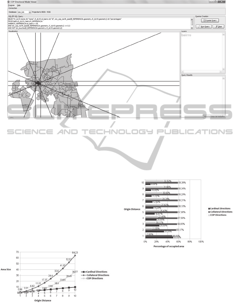
Figure 9: COP-VW result for “Find Target” query example.
Line/Polygon, Line/Line and Line/Point pairs. We
carry out these cases in the SDMS extension and
COP-VW only invoked them.
4.3 Discussion
Projection grid tends to partition the
disproportionately space in that it moves away from
the origin, favoring Side directions. The COP Model
managed to minimize this by superimposing a
conical grid. There were growth areas of the
partitions to verify divisions generated by the COP
Model. For this we used the same parameters used in
the projection grating, or square with 1 unit MBR
side and offset from 1 to 10 units away from the
origin. Figure 10 shows the percentage distribution
of space between the cardinals, side directions and
added by COP.
Figure 10: Growth Chart of directions in COP Model.
We show in Figure 10 an even exponential growth
of the area presenting the Side directions and
straight to the Cardinals directions. However
directions added by COP Model also grow
exponentially, which balances the growth of side
directions, so this is not reaching the 59% of the
partitioned area, as shown in Figure 11.
Figure 11: Percentage of space occupied by the COP
Model directions.
According to user interpretation, areas of the
cardinal directions with their respective COP
directions can be added, and the COP directions are
influenced by the cardinal directions. These
considerations balance cardinals and collaterals.
Figure 12 shows a comparison between the
percentage areas occupied by cardinals and
collaterals directions with the projection grid and the
COP Model grid. We have the values related to
WEBIST2015-11thInternationalConferenceonWebInformationSystemsandTechnologies
250
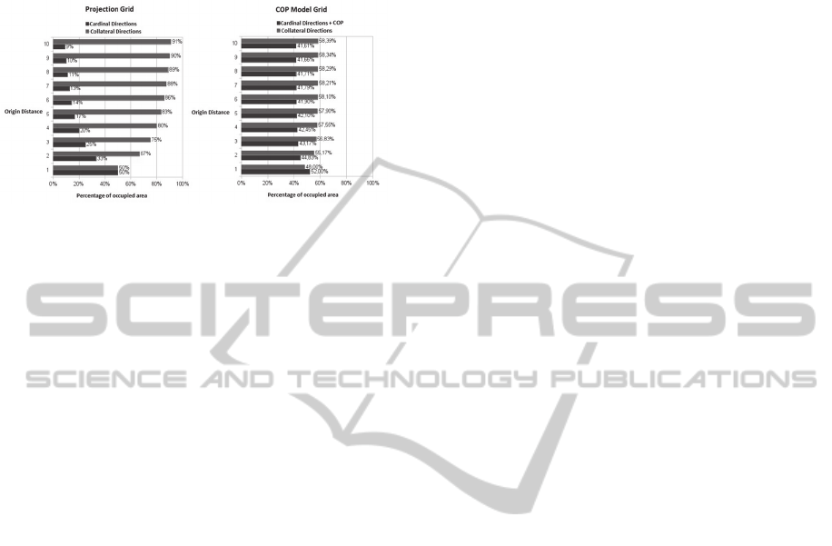
cardinal directions and their respective influenced in
the last one.
Figure 12 shows that with the COP Model grid,
the growth of side areas is no longer exponential and
Figure 12: Comparison between Projection and COP
Model partitions.
is replaced by closer linearity behaviour. Also be
seen that as it moves away from the source, the gap
in favour of the side direction continues to grow, but
in smaller and smaller quantities. On the whole, the
difference in areas that time had reached 82% in the
Projection grid fell to 16.78% with the grid of the
COP Model in this given situation. Thus, the model
reduced the discrepancy between the areas by a
significant way.
5 CONCLUSIONS
As a result of this work we granted some tangible
artefacts: The mathematical definition of the COP
Model, the COP ME (a suite of products that form
the seamless deployment to SDMS), and COP-VW
Geographical Information System.
The COP-VW allows to verify the COP Model
implementation via Web, and to show that spatial
processing functions carried out in the COP-ME are
usable by a third-party software without needing
redeployment or any specific suitability.
The presented GIS is the COP Model
implementation from visual and friendly way. The
implemented features could be tested individually
and with existing features in SDMS, such as on the
topological and metric relationships, so it was
indeed found the implementation was faithful to the
model definition. Further, the COP-VW can also be
used as a graphic viewer geometries stored in any
database that uses PostgreSQL/Postgis, regardless of
whether or not using the COP-ME extension. COP-
VW works with a Geodatabse located in a Web
platform. This feature allows free access to
information and supports decisions related to
environmental and urban planning. Decision makers
can visualize several databases in different
geographical locations. This point is a strong feature
of work.
As further work, we intend to develop the COP-
VW in a Mobile platform. Finally, we stress that all
procedures performed and created products were
made using technologies free/opensource, which
made the COP-VW free of the need to pay license
fees, both for developers and for those using.
REFERENCES
Egenhofer, M., 2000. Qualitative Spatial-Relation
Reasoning for Design. National Center for Geographic
Information and Analysis, Department of Spatial
Information Science and Engineering Department of
Computer Science. University of Maine Orono, USA.
Egenhofer, M.; Herring, J., 1991. Categorizing Binary
Topological Relationships Between Regions, Lines,
and Points in Geographic Databases. Orono, ME:
Department of Surveying Engineering, University of
Maine.
Egenhofer, M.; Franzosa, R., 1995. On the Equivalence of
Topological Relations. International Journal of
Geographical Information Systems, v. 9, n.2, p. 133-
152.
Frank, A. U., 1992. Qualitative spatial reasoning about
distances and directions in geographic space, J. Visual
Lang. Comput., 3, 343–371.
Papadias, D., Theodoridis, Y., 1997. Spatial Relations,
Minimum Bounding Rectangles, and Spatial Data
Structures. International Journal of Geographic
Information Science 11(2), 111-138.
Peuquet, D., Zhan, C. X., 1987. An Algorithm to
Determine the Directional Relation Between
Arbitrarily-Shaped Polygons in the Plane, Pattern
Recogn., 20, 65–74.
Silva, J. A. da and Fook, K. D., 2013. Addition of the
Directionality Concept in Spatial Queries on SDMSs
Using the Union of the Cone-Based and Projection-
Based Models. Proceedings of XIV Brazilian
Symposium on Geoinformatics - GEOINFO,
November 24-27, Campos do Jordão, Brazil. ISSN:
2179-4820.
Spiros, S., Nikos, S., Timos, S., Manolis, K., 2007. A
Family of Directional Relation Models for Extended
Objects, IEEE Transactions on Knowledge and Data
Engineering, 19(8), pp.1116-1129.
Tang, X., Meng, L., Qin, K., 2008. Study On The
Uncertain Directional Relations Model. Based On
Cloud Model. The International Archives of the
Photogrammetry, Remote Sensing and Spatial
Information Sciences. Vol. XXXVII. Part B2. Beijing.
Theodoridis, Y., Papadias, D., Stefanakis, E., 1996.
Supporting Direction Relations in Spatial Database
Systems, Spatial data handling International
Symposium. In 7th, Spatial data handling, ISBN:
COP-VW:Cone-over-ProjectionDirectionalModelViewer
251

0748405917.
Xia, Y., Zhu, X., Li, D., Qin, K., 2007. Research on spatial
directional relation description model, Science of
Surveying and Mapping, 32(5), pp.94-97.
Zhu, X., Chen, D., Zhou, C., Li, M., Xiao, W., 1012.
Cardinal Direction Relations Query Modeling Based
on Geo-Ontology, State Key Laboratory of
Information Engineering in Surveying, Mapping and
Remote Sensing, Wuhan University, International
Archives of the Photogrammetry, Remote Sensing and
Spatial Information Sciences, Volume XXXIX-B2,
2012 XXII ISPRS Congress, 25 August – 01
September 2012, Melbourne, Australia.
WEBIST2015-11thInternationalConferenceonWebInformationSystemsandTechnologies
252
