
The RITMARE Starter Kit
Bottom-up Capacity Building for Geospatial Data Providers
Cristiano Fugazza
1
, Stefano Menegon
2
, Monica Pepe
1
, Alessandro Oggioni
1
and Paola Carrara
1
1
IREA-CNR, via Bassini 15 - 20133 Milano, Italy
2
ISMAR-CNR, Arsenale - Tesa 104, Castello 2737/F, 30122 Venezia, Italy
Keywords:
Spatial Data Infrastructures, OGC Services, SWE, Marine Research.
Abstract:
Capacity building by data providers is a fundamental task in the creation of a decentralized Spatial Data In-
frastructure. This challenge has been tackled in the RITMARE Flagship Project by providing the Starter Kit,
a comprehensive set of domain-oriented software components that exposes standard services for the manage-
ment of geospatial information. We report on the characteristics of this toolkit, developed by the National
Research Council of Italy (CNR), particularly with regard to the underlying service-oriented architecture and
the novel semantics-aware methodology that is proposed for metadata editing.
1 INTRODUCTION
Spatial Data Infrastructures (SDIs) are frameworks
for the collection and provisioning of geospatial data,
metadata, networked services, and technologies. A
number of standard services, such as the Web Map
Service (WMS), allow for download and visualization
of the resources that are discovered through a Cata-
log Service for the Web (CSW)
1
interface. In fact,
differently from generalized search, where indexing
and retrieval is driven by crawling (hyper)textual data
on the Web, an SDI relies on specific metadata for-
mats and access protocols to enable “discovery” of
resources by users. It is essential for data providers
to comply with such metadata formats (actually, they
are often mandated to) and to expose appropriate ser-
vices in order to mesh with existing data collections
and to enable aggregation of their data by third-party
applications (Gil et al., 2012; De Longueville, 2010).
Unfortunately, implementing a full-fledged infras-
tructure of this kind may feature a steep learning
curve preventing researchers from properly manag-
ing the required technicalities. As a consequence,
the exploitation of important datasets by the research
community may be indefinitely confined to word-of-
mouth. State-of-the-art SDI solutions may also make
it difficult to seamlessly integrate novel categories
of data sources, such as sensor data (Na and Priest,
1
Catalog Service for the Web:
http://www.opengeospatial.org/standards/cat
2007). Moreover, the evolution of resource anno-
tation paradigms, such as the change in perspective
driven by Semantic Web technologies (Hitzler et al.,
2009), makes existing infrastructures for geospatial
data inadequate.
IREA-CNR tackled the challenge of providing an
infrastructure to RITMARE, the Flagship Project for
Italian marine research
2
. The variety of data formats
and practices enforced by the distinct data providers,
as well as the different degree of maturity of existing
solutions, rule out any kind of “integration by stan-
dardization” approach. We favor instead a bottom-up
methodology that may capitalize as possible on the
practices established by individual data providers.
Among these, we first considered those with
no existing infrastructure in order to abstract from
protocol-level integration issues, focusing instead on
the heterogeneity of data formats. This also allowed
us to set a baseline for metadata which, in the Euro-
pean Union (EU), require standardization according
to the INSPIRE Directive (European Commission,
2007), enforced in Italy by the Repertorio Nazionale
dei Dati Territoriali (RNDT)
3
. The outcome is the
RITMARE Starter Kit (SK), a capacity-building col-
lection of software components packaged as a ready-
to-use virtual appliance. The SK exposes standard
data distribution services and establishes a CSW cat-
alog service by the data providers.
2
RITMARE Flagship Project: http://www.ritmare.it/
3
RNDT: http://www.rndt.gov.it
169
Fugazza C., Menegon S., Pepe M., Oggioni A. and Carrara P..
The RITMARE Starter Kit - Bottom-up Capacity Building for Geospatial Data Providers.
DOI: 10.5220/0004999801690176
In Proceedings of the 9th International Conference on Software Paradigm Trends (ICSOFT-PT-2014), pages 169-176
ISBN: 978-989-758-037-6
Copyright
c
2014 SCITEPRESS (Science and Technology Publications, Lda.)

The catalog service that is exposed can either be
used in isolation, for the discovery of resources made
available by the specific data provider, or be exploited
by a centralized catalog service integrating the dis-
tinct contributions to the project. The infrastructure’s
central node also empowers the SK with metadata
editing capabilities that are based on a collection of
semantics-aware, RDF data structures
4
, as explained
in (Fugazza et al., 2014).
Section 2 outlines the RITMARE infrastructure
as a response to the project’s heterogeneous audience
and to the normative constraints for the management
of geospatial data in Italy as well as in the EU; it
also presents some related work that is relevant to
the project. Section 3 details the characteristics of
the SK with regard to the software provided and the
services that are exposed to either end users and the
centralized catalog. Section 4 describes the main con-
tributon of the SK to the state-of-the-art, that is, the
metadata editing service that allows for the creation
of semantically-annotated metadata. Section 5 pro-
vides a preliminary evaluation of the approach that is
presented. Finally, Section 6 draws conclusions and
outlines future work.
2 THE SK IN THE RITMARE
ARCHITECTURE
RITMARE is a Flagship Project by the Italian Min-
istero dell’Istruzione, dell’Universit
`
a e della Ricerca
which aims at fostering data sharing among the Italian
data providers in the field of marine research. Sub-
project 7 is charged of building the SDI to be em-
ployed by the data providers themselves (public re-
search bodies and inter-university consortia) and also
by a variety of stakeholders (public administrations,
private companies, and citizens).
A coarse-grained categorization of SDIs distin-
guishes between centralized and decentralized infras-
tructures, according to whether data and metadata is
stored in a single repository or distributed among the
distinct data providers. The RITMARE infrastructure
will belong to the second kind, comprising:
• a set of peripheral nodes that expose standards-
compliant metadata and services;
• a node that provides a centralized catalog, single
point of access to the resources made available by
the project as a whole.
The rationale for adopting a decentralized strategy is
manifold. Firstly, by doing this, the implementation
4
Resource Description Framework:
http://www.w3.org/RDF/
strategies of existing infrastructures are not hampered
by inclusion in the RITMARE SDI. Also, this ap-
proach allows data providers to retain full control over
their data, metadata, and provisioning facilities. Fi-
nally, by federating the distinct data sources, no cen-
tralized management of sensitive data about users is
required.
Data providers in RITMARE are scientists be-
longing to different communities (e.g., oceanogra-
phy, ecosystems, biogeochemistry, geophysics, etc.).
As a consequence, they envisage a varied corpus of
heterogeneous data, metadata, workflows, and re-
quirements. They also feature different degrees of
maturity with regard to the solutions implemented
for the provisioning of resources. This heterogene-
ity has been addressed by structuring the develop-
ment activity in three incremental phases. The first
one consists of empowering the data providers with
standards-compliant services for the collection, anno-
tation, and deployment of both geographic and sensor
data, which is the purpose of the SK described in this
work. The data sources that already expose standard
services will be integrated in the second phase. Fi-
nally, the third phase will be the building of the cen-
tralized portal accessing the distinct peripheral nodes
and exposing the metadata records as Linked Data.
A sketch of the interactions between end users,
SK instances, and the centralized catalog is depicted
in Figure 1 (directed arcs indicate which entity ac-
cesses which). In the picture, three distinct installa-
tions of the SK provide heterogeneous data (buoys
data, bathymetries, and radar data) by exposing the
services that are of interest to the specific category of
data. Three categories of end users can access each
of the peripheral nodes created by the SK both for
the discovery of resources and for the actual down-
load of data. These are data producers, stakehold-
ers, and third-party applications within and outside
the project. The centralized catalog of the RITMARE
infrastructure aggregates metadata records from the
distinct data sources so that the user can search for
datasets made available by any of the harvested SK
installations. Stored by this central node, RDF data
structures support metadata creation by the peripheral
nodes and enable advanced discovery functionalities.
2.1 Related framework
INSPIRE-compliant, XML-based metadata and
OGC-based services (European Commission, 2008;
IOC Task Force for Network Services, 2011a;
Initial Operating Capability Task Force, 2012; IOC
Task Force for Network Services, 2011b) set the
framework for interoperability of geospatial data
ICSOFT-PT2014-9thInternationalConferenceonSoftwareParadigmTrends
170
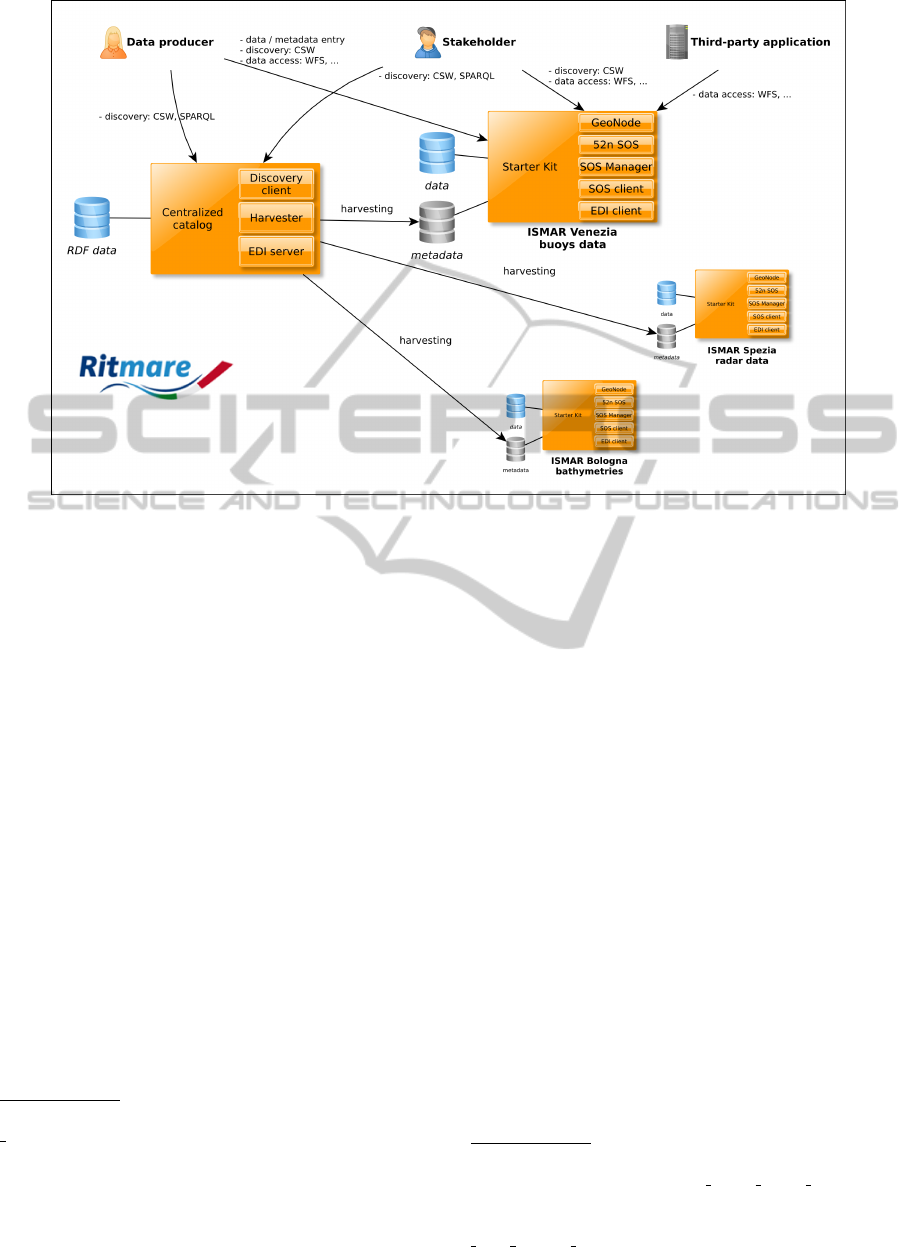
Figure 1: Instances of the Starter Kit in the RITMARE infrastructure.
among European countries. Whereas the framework
provides “stubs” for bridging between mere protocol-
level and real semantic interoperability (e.g., the
multilingual codelists employed in metadata), it is
unwieldy to accommodate these features in ISO
19115 format
5
, the XML schema mandated by the
Directive. This is the rationale for collecting, besides
INSPIRE-compliant metadata, additional information
that could ease implementation of more fine-grained
search paradigms.
Another integration challenge is constituted by
sensor networks, which represent an application field
that is mature enough for inclusion in our infrastruc-
ture. The integration of sensor observations within
SDIs is featuring many examples (Jiang et al., 2013;
Hale and Hollister, 2009; Voigt et al., 2009; Collins
et al., 2006). Also, many implementations are sup-
porting the requirements for Sensor Web Enable-
ment (SWE)
678
. However, the challenge of integrat-
ing sensor networks, particularly observations (the ac-
tual data produced by sensors), with traditional geo-
graphic data remains. In fact, Sensor Web develop-
ment relies on specific standards and practices that
5
ISO 19115: http://www.iso.org/iso/catalogue
detail.htm?csnumber=26020
6
52
◦
North: http://52north.org/communities/sensorweb/
index.html
7
OOSTethys: https://code.google.com/p/oostethys/wiki/
JavaServerMain
8
istSOS: http://istgeo.ist.supsi.ch/software/istsos/
make it difficult to achieve this degree of integration.
3 THE RITMARE STARTER KIT
The main purpose of the SK is to enable researchers
and research organizations to contribute their data and
metadata to the RITMARE interoperable infrastruc-
ture. By means of the SK, data providers can upload
and manage their data (both maps and observations),
create the appropriate metadata for either datasets and
sensors, and finally provide discovery, visualization,
and access interfaces according to the standards. We
focused on three main strategies:
• to simplify as much as possible the installation of
the tools;
• to allow data providers to easily and directly man-
age, publish, and share their geospatial and obser-
vation datasets (without specific skills on SDIs);
• to foster reuse of the services provided by the SK
in projects and initiatives outside RITMARE.
The SK is distributed as a ready-to-use virtual appli-
ance which is packaged in the Open Virtualization
9
WMS Tiling Clients Recommendation:
http://wiki.osgeo.org/wiki/WMS Tiling Client Recommen-
dation
10
Tile Map Service: http://wiki.osgeo.org/wiki/Tile
Map Service Specification
TheRITMAREStarterKit-Bottom-upCapacityBuildingforGeospatialDataProviders
171

Table 1: Services exposed by the Starter Kit.
SERVICE VERSION NOTES
OCG Web Map Service 1.1.1, 1.3.0 from GeoNode (GeoServer)
OGC Web Feature Service 1.0.0, 1.1.0, 2.0 from GeoNode (GeoServer)
OGC Web Coverage Service 1.0, 1.1 from GeoNode (GeoServer)
OGC Styled Layer Descriptor 1.0 from GeoNode (GeoServer)
OSGeo WMS Tiling Clients Recommendation
9
from GeoNode (GeoWebCache)
OGC Web Map Tiling Service from GeoNode (GeoWebCache)
OSGeo Tile Map Service
10
a predecessor to WMTS, from GeoNode (GeoWebCache)
OGC Catalogue Services for the Web 2.0.2 from GeoNode (pycsw)
INSPIRE Discovery Services 3.0 from GeoNode (pycsw)
Search/Retrieve via URL (SRU) search protocol from GeoNode (pycsw)
OGC SOS 1.0.0 from 52
◦
North SOS
OGC Sensor Model Language (SensorML) 1.0.1 from 52
◦
North SOS
OGC Observation and Measurement (O&M) 1.0.0 from 52
◦
North SOS
OGC Geography Markup Language (GML) 3.1.1 from 52
◦
North SOS
Format (OVF)
11
. The SK is based on the Ubuntu op-
erating system and contains open-source software. In
a nutshell, the SK is a web-based application and plat-
form kickstarting a node in the SDI which is capable
of managing geospatial and observation datasets and
resources.
Besides the software that has been specifically
created for the requirements of RITMARE, the SK
also features a number of services provided by GeoN-
ode and 52
◦
North SOS, see Table 1. The SK is
partly based on results of the CIGNo project (Berga-
masco et al., 2011), a collaborative, federated system
to share scientific and geographic data.
The software that has been customized or created
for the SK allows to keep the data, metadata, and ser-
vices tightly coupled. As an example, several meta-
data items are automatically extracted from datasets at
upload-time and passed down to the metadata editor
for insertion in the metadata record. The components
that have been developed expressively for the SK are
the following:
SOS Manager. Supports editing of SensorML for
registering a new sensor and allows upload of ob-
servations as tabular data in a text file.
SOS Client. The interface allows to easily interact
with an SOS service to retrieve, for each sensor,
position, parameter list, offerings, and values.
EDI Client. The client-side component of the cus-
tomizable, semantics-aware metadata editing ser-
vice described in Section 4.
The management of geographic information is pri-
marily mandated to GeoNode
12
(Benthall and Gill,
11
Open Virtualization Format:
http://www.dmtf.org/standards/ovf
12
GeoNode: http://geonode.org/
2010; Winslow, 2010), a widely acknowledged open-
source software that is capable of dealing with maps,
geographic layers, and also with geotagged docu-
ments. Besides geographic information, the SK is
also capable of uploading, storing, and publishing
sensor descriptions and the observations captured by
the former. The main component that is bundled is
the implementation by 52
◦
North
13
of the Sensor Ob-
servation Service (SOS) specification and related fa-
cilities.
Since the services that are exposed by the two
aforementioned components are differing in many as-
pects, the workflows for inserting in the SK, respec-
tively, geographic and sensor data are kept separated.
By doing this, all the extra features provided by the
SOS implementation are retained. On the other hand,
the coupling of the two categories of data sources
emerges in the visualization features that are pro-
vided. In fact, integrated with the GeoNode Map
Composer, the SOS Client executes requests and re-
trieves the data from an SOS endpoint, so that users
can display on a GIS-like interface the position of sen-
sors. The sensors can then be queried for the time se-
ries that are made available for one or more observed
parameters: Data can either be displayed in classic
tabular mode or be applied data visualization criteria.
The SOS Client is a JavaScript library based on Open-
Layers
14
, ExtJS
15
, and Flot
16
.
13
52
◦
North: http://52north.org/
14
OpenLayers: http://openlayers.org/
15
ExtJS: http://www.sencha.com/products/extjs/
16
Flot: https://code.google.com/p/flot/
ICSOFT-PT2014-9thInternationalConferenceonSoftwareParadigmTrends
172

Listing 1: Code fragment from the RNDT template.
1 < element >
2 < la bel lang =" it "> T ip o di r a p p r e s e n t a zi o n e spa zi al e </ label >
3 < la bel lang =" en "> S p a tia l re p r e s e n t a t i o n type </ label >
4 < is M and ato r y > forAl l </ isM and ato r y >
5 < is Mul tip le > true </ i sM u lt i ple >
6 < has Ro ot >
7 / gmd : MD _ M e t a d a t a / gmd : i d e n t i f i ca t i o n I n f o / gmd : MD _ D a t a I d e n t i fi c a t i o n
8 </ hasRoot >
9 < prod uc es >
10 < item >
11 < has In dex >1 </ ha sInde x >
12 < hasPath >/. . ./ g md : M D _ S p a t i a l R e p r e s e n t a t i o n T y p eC o d e </ hasPath >
13 < isFixed > false </ isFixed >
14 < h asD a tat y pe > code </ h asD ata t ype >
15 < has Va lue > http :/ / . ../ M D _ S p a t i al R e pr e s en t a ti o n Ty p e Co d e / items </ ha sV alu e >
16 </ item >
17 < item >
18 < has In dex >2 </ ha sInde x >
19 < hasPath >/. . ./ g md : M D _ S p at i a lR e p re s e nt a t io n T yp e C od e / @cod eL ist </ hasPath >
20 < isFixed > true </ is Fi xe d >
21 < h asD a tat y pe > stri ng </ ha s Dat a typ e >
22 < has Va lue >
23 http : //. . . / g m x C o d e l i sts . xml # M D _ S p at i a lR e p re s e nt a t io n T yp e C od e
24 </ h as Value >
25 </ item >
26 < item >
27 < has In dex >3 </ ha sInde x >
28 < hasPath >
29 /. ../ gmd : MD_ S p a t i a l Re p r es e n ta t i on T y pe C o de / @codeListValue
30 </ hasPath >
31 < isFixed > true </ is Fi xe d >
32 < h asD a tat y pe > ref </ has D ata typ e >
33 < has Va lue > /.. . / gmd : M D _ S p a t i a l R e p r e s e n t a t i o nT y p e C o d e </ ha sValu e >
34 </ item >
33 </ p ro duces >
34 ...
35 </ ele me nt >
4 METADATA CREATION IN THE
SK
One of the most important components in the SK is
EDI, a customizable, template-driven metadata editor
that has been developed within RITMARE by lever-
aging a variety of complementary techniques. The ra-
tionale for this is to employ the more appropriate tech-
nology for each of the distinct phases in the workflow
for metadata creation. For the time being, we support
the editing of RNDT (i.e., INSPIRE) and SensorML
metadata. However, the data model underlying tem-
plate creation, encoded as an XML Schema
17
, should
be expressive enough to support most of the metadata
formats in the SDI domain. As an example, support
for sensor metadata in the alternative *FL (Starfish
Fungus Language) format (Simonis and Malewski,
17
XML Schema: http://www.w3.org/XML/Schema
2011) is under testing.
The only input required by EDI to assist compo-
sition of metadata records in a given XML format is
an appropriate template. The template language in-
troduces the primitives that are necessary for the def-
inition of metadata elements, intended as high-level
abstraction of the information that can be either pro-
vided by the user or pre-computed by the application
itself (such as the geographic boundary, the so-called
“bounding box”, that can be automatically computed
at data upload-time). Each element defines one or
more items that correspond to the individual XML
nodes (elements and attributes) that are populated in
the metadata record. Listing 1 shows a fragment of
the RNDT template governing the creation of meta-
data in the ISO 19115 XML format, the standard un-
derlying INSPIRE metadata.
The essential information defining an element is
the language-dependent textual representation to be
TheRITMAREStarterKit-Bottom-upCapacityBuildingforGeospatialDataProviders
173
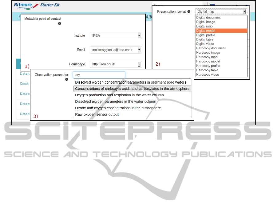
Figure 2: Portion of the EDI metadata editing interface.
displayed in the interface (lines 2 and 3), the compul-
soriness of the metadata item (one of “forAll”, “for-
Data”, “forServices”, “forSensors”, and “NA” on line
4), its multiplicity (line 5), and the XPath defining
the position where multiple instances of the metadata
field shall be rooted (lines 6-8). Instead, the distinct
items associated with the element define the specific
XML nodes that shall be generated. In the HTML
form interface generated by EDI, the user is presented
the form fields that correspond to items whose param-
eter isFixed is set to “false” (as on line 13). For these,
parameter hasDatatype specifies the data type of the
specific metadata element. In the listing, the first item
defining element “Spatial representation type” is of
type “code”, meaning that the possible values shall be
taken from a controlled vocabulary: In this case, pa-
rameter hasValue specifies the unique identifier (the
URI) that is necessary for retrieving the allowed val-
ues for the field.
EDI processes the template through an XSLT
stylesheet, the most suitable means for processing
XML data, and generates the actual HTML form that
is displayed in the user’s browser. Still, this interface
is a dumb form that only distinguishes between input
fields, text areas, dropdown lists, etc. but whose input
fields and text areas have no predefined values, whose
dropdown lists have no options (the values selectable
by the user), etc. In fact, it is up to the JavaScript com-
ponent of EDI to dynamically load these contents: For
doing this, the JavaScript code accesses codelists and
controlled vocabularies stored in the RDF triple store
on the server-side, as described in (Fugazza et al.,
2014). These categorizations of terms also provide
all the accessory information that is required for cre-
ating the items that are either fixed or dependent on
the user’s choices (the items whose parameter isFixed
is set to “true”).
Let aside relieving the user from the burden of
providing these additional data, recourse to RDF data
structures allows the SK to annotate metadata with
unique identifiers (e.g., the URI corresponding to the
INSPIRE Theme the user may select) that will be used
later on, when metadata is harvested by the central
catalog collecting the contributions of the distinct pe-
ripheral nodes of the RITMARE infrastructure. This
information may not be exposed (or leveraged on in
discovery) by the individual catalogs of peripheral
nodes but constitutes the fundamental step for pro-
viding advanced query functionalities by the overall
infrastructure. Also, among the RDF data that EDI
accesses for initializing the form fields is information
related to the institution hosting the peripheral node of
the infrastructure. This allows the client application to
suggest values for a number of metadata fields.
Specifically, the semantics-aware characterization
of data items allows the interface to provide three dis-
tinct functionalities:
• the automatic provision of values for metadata
fields whose content depends on the choices that
have been made for other metadata fields;
• the generation of dropdown lists on the basis of
the mandated codelists, translated into the specific
language that is chosen for the metadata;
• the autocompletion of metadata fields whose val-
ues shall be taken from controlled vocabularies
that are too large for rendering as a dropdown list.
Figure 2 shows a portion of the HTML form that
ICSOFT-PT2014-9thInternationalConferenceonSoftwareParadigmTrends
174

is generated by EDI after the execution of both the
XSLT transformation and the JavaScript code men-
tioned above. In particular, the image focuses on
three distinct fields (the metadata point of contact, the
presentation format, and the observation parameter a
given dataset is related to) to exemplify the three dis-
tinct means we evisaged for the assisted editing of
metadata.
In box 1, the authentication information that has
been provided by the user allows the interface to sug-
gest the distinct metadata items that are required for
specifying a point of contact (the institution the per-
son is working by, the website associated with the for-
mer, and the person’s email address). Box 2 allows
for the specification of the presentation format by se-
lecting among the codes that have been defined by the
INSPIRE Directive. The list (as well as field names,
interface menus, and buttons) is populated on the ba-
sis of the language that is chosen for metadata edit-
ing. Finally, box 3 shows the input field that is used
for providing the observation parameter (a keyword in
the ISO metadata lexicon): Autocompletion capabil-
ities provide the user with the range of observation
parameters defined by SeaDataNet
18
, an outstanding
European marine project.
Once fields have been filled in, the EDI Client
posts the metadata to the EDI service hosted by the
central node of the RITMARE infrastructure. This
metadata is used for accomplishing two distinct activ-
ities. On the one hand, to create a metadata record
that has all the expressiveness elicited by the inter-
face (essentially, an XML file very similar to the orig-
inal template, whose fields are filled in with the ac-
tual values entered by the user). Secondly, the actual
XML corresponding to the metadata format the tem-
plate was written for is produced (for the time being,
either RNDT or SensorML). Both these files are sent
back to the local SK installation.
5 DISCUSSION
In the current phase of the project, when the cen-
tralized geoportal is still work in progress, an overall
evaluation of the proposed solution is not easy. How-
ever, we are already collecting feedback on the ca-
pacity building of data providers envisaged in the first
phase of the project (see Section 2), that is, we can
report on the efficacy of our Starter Kit. In particular,
we can evaluate the features that we are providing for
the assisted editing of metadata.
With respect to these, recourse to the RDF data
18
SeaDataNet: http://www.seadatanet.org/
structures allows to dramatically reduce the number
of the data items to be actually provided by the user.
As an example, the RNDT specification is featuring
34 mandatory metadata items, too high a number for
an accurate editing of metadata records. Moreover,
some of these, such as the 4 distinct contact points to
be provided, are composite items that require more
than one value to be entered by the user. Instead,
by combining i) the automatic assignment of meta-
data items, ii) the provision of default values extracted
from the dataset itself, and iii) the exploitation of the
RDF information described in (Fugazza et al., 2014),
the number of required values can be narrowed down
to 10.
Particularly, by referring to the project structure,
the editing interface is capable of providing data items
that are otherwise tedious to provide or error-prone.
Also, autocompleting keywords from the selected the-
sauri configures a win-win situation where the user is
relieved of the burden of writing keywords in their
entirety and the application is capable of associat-
ing unique identifiers with the keywords that are pro-
vided. These advanced editing capabilities can be ap-
plied to generic metadata schemata encoded as XML.
In fact, we currently support the editing of sensor
metadata in the SensorML format with the same au-
tocompletion facilities of RNDT metadata.
An important requirement that has been underesti-
mated in the analisys phase is the need for appropriate
updating and monitoring facilities. In fact, once indi-
vidual nodes are up and running, it is extremely diffi-
cult to update remote components without hampering
operativeness of the node. Another lesson learnt is
related to dependencies on third-party software that
require thorough testing before upgrading the version
provided in the SK. Specifically, when migrating from
version 3.2 to version 4.0 of the 52
◦
North SOS imple-
mentation, much work was required for updating the
interfaces between this software and the rest of the
SK.
6 CONCLUSIONS
This paper described the approach to capacity build-
ing for geospatial data providers that has been adopted
in project RITMARE. A variety of open-source soft-
ware has been bundled in the Starter Kit, a virtual
appliance capable of establishing a fully-functional
SDI node out-of-the-box. A comprehensive set of
standards-compliant services allows to easily manage
both geographic data and sensor observations; the SK
also provides a uniform mechanism for metadata cre-
ation. Set-up of the nodes in the RITMARE SDI that
TheRITMAREStarterKit-Bottom-upCapacityBuildingforGeospatialDataProviders
175

are based on the SK is ongoing.
The overall infrastructure contributes to the enact-
ment of the SK installations by providing services for
the management of metadata that annotate resources
semantically. These annotations are then employed
by the central node for a twofold purpose: i) to im-
plement novel techniques for the organization of wid-
gets in the geoportal’s main interface and ii) to en-
able inter-disciplinary discovery of the geospatial re-
sources that are aggregated.
Future steps will involve the integration into the
infrastructure of the data providers that already ex-
pose suitable services. Some existing tools, such as
the GI-cat brokering application
19
, already allows ac-
cess to heterogeneous data sources. This is interop-
erability at protocol-level while, in our scenario, the
challenge is to allow the research communities to in-
teroperate at a higher level. As an example, the ex-
pressiveness of individual metadata items should be
augmented through lookup in controlled vocabularies
or semantic indexing methodologies.
RITMARE will provide a uniform point of access
to all the data sources involved in the project (either
SK instances or not); the user interface will flexibly
adapt to the interests, requirements, practices, and de-
vices of individual researchers in the project.
ACKNOWLEDGEMENTS
The activities described in this paper have been
funded by the Italian Flagship Project RITMARE.
REFERENCES
Benthall, B. and Gill, S. (2010). SDI Best Practices with
GeoNode. In Proceedings of Free and Open Source
Software for Geospatial Conference (FOSS4G 2010).
Bergamasco, A., Guerzoni, S., Masiero, E., Menegon, S.,
Morgantin, M., Rosina, A., Sarretta, A., and Vianello,
A. (2011). Collaborative Interoperable Geographic
Node in Venice Lagoon. In Data Flow from Space
to Earth: International Conference, Venice, Italy.
Collins, S. L., Bettencourt, L. M., Hagberg, A., Brown,
R. F., Moore, D. I., Bonito, G., Delin, K. a., Jack-
son, S. P., Johnson, D. W., Burleigh, S. C., Woodrow,
R. R., and McAuley, J. M. (2006). New opportunities
in ecological sensing using wireless sensor networks.
Frontiers in Ecology and the Environment, 4(8):402–
407.
De Longueville, B. (2010). Community-based geoportals:
The next generation? Concepts and methods for the
19
GI-cat: http://essi-lab.eu/do/view/GIcat
geospatial Web 2.0. Computers, Environment and Ur-
ban Systems, 34(4):299–308.
European Commission (2007). Establishing an Infrastruc-
ture for Spatial Information in the European Commu-
nity (INSPIRE) Directive 2007/2/EC.
European Commission (2008). Commission regulation
(EC) no 1205/2008 of 3 December 2008 implement-
ing Directive 2007/2/ec of the European Parliament
and of the Council as regards metadata.
Fugazza, C., Pepe, M., Oggioni, A., Pavesi, F., and Car-
rara, P. (2014). A holistic, semantics-aware approach
to Spatial Data Infrastructures. In 3rd International
Conference on Data Management Technologies and
Applications (DATA).
Gil, J., D
´
ıaz S
´
anchez, L., Granell, C., and Huerta Guijarro,
J. (2012). Open Source Based Deployment of En-
vironmental Data into Geospatial Information Infras-
tructures. International Journal of Applied Geospatial
Research (IJAGR), 3(2):6–23.
Hale, S. S. and Hollister, J. W. (2009). Beyond data man-
agement: how ecoinformatics can benefit environ-
mental monitoring programs. Environmental Moni-
toring and Assessment, 150(1-4):227–235.
Hitzler, P., Krtzsch, M., and Rudolph, S. (2009). Founda-
tions of Semantic Web Technologies. Chapman & Hal-
l/CRC, 1st edition.
Initial Operating Capability Task Force (2012). Technical
Guidance for the Implementation of INSPIRE down-
load services.
IOC Task Force for Network Services (2011a). Technical
Guidance for the Implementation of INSPIRE discov-
ery services.
IOC Task Force for Network Services (2011b). Technical
Guidance for the Implementation of INSPIRE view
services.
Jiang, Y., Guo, Z., Hu, K., Shen, F., and Hong, F. (2013).
Using Sensor Web to Sharing Data of Ocean Observ-
ing Systems. In Wang, R. and Xiao, F., editors, Ad-
vances in Wireless Sensor Networks, pages 137–156.
Springer-Verlag, Berlin Heideberg.
Na, A. and Priest, M. (2007). OGC Sensor Observation
Service (OGC 06-009r6). OpenGIS Implementation
Standard.
Simonis, I. and Malewski, C. (2011). *FL Starfish Fungus
Language for sensor description. OGC discussion pa-
per 11-058r1.
Voigt, T., Tsiftes, N., and He, Z. (2009). Remote Wa-
ter Monitoring With Sensor Networking Technology.
Ercim News, 2009(76):39–40.
Winslow, D. (2010). GeoNode Architecture: wrangling
$100 million worth of open source software to make
SDI building a walk in the park. In Proceedings of
Free and Open Source Software for Geospatial Con-
ference (FOSS4G 2010).
ICSOFT-PT2014-9thInternationalConferenceonSoftwareParadigmTrends
176
