
A (Near) Real-time Validation and Standardization System Tested
for MAMBO1 Meteo-marine Fixed Station
Elena Partescano
1
, Alessandra Giorgetti
1
, Caterina Fanara
1
, Alessandro Crise
1
,
Alessandro Oggioni
2
, Alberto Brosich
1
and Paola Carrara
2
1
OGS (Istituto Nazionale di Oceanografia e di Geofisica Sperimentale)
Borgo Grotta Gigante 42/c, 34010 Sgonico, Trieste, Italy
2
CNR IREA UOS Milano, Via Bassini 15, I20133 Milano, Italy
Keywords: Sensor Web Enhancement, Near Real-time, Meteo-oceanografic Buoy.
Abstract: The objective of this paper is to describe a new application developed to deliver validated data in (near)
real-time from marine stations, together with a complete set of information. The harvesting of marine (near)
real-time data with multiple data formats, the conversion in a homogeneous and standard format, the
structuring in a database and, finally, the automation of the marine data validation is obtained using XML
and OGC (Open Geospatial Consortium) standards for data transport and representation. The adoption of
Sensor Web Enablement (SWE) specifications enables real time integration of data and metadata, related to
the data processing and calibration, the data collection instruments and the data quality control. Our
technological choice is led by the requirements of interoperability, as ability to cooperate and exchange
information, and resilience, as ability of adaptation to new needs. The international standard SensorML has
been used as a profile, adapted to our needs and results as a joint effort of the Italian RITMARE, the
European SeaDataNet, Eurofleet and ODIP community.
1 INTRODUCTION
This work started from the need to archive, validate
and deliver data in (near) real-time from marine
stations. A series of difficulties has been addressed
because the marine data are heterogeneous, being
collected by different sensors and with different data
formats. Furthermore, the data validation procedure
should be able to apply a quality control to the single
measurements, eventually by comparison with
climatological mean values and assigning a data
quality flag without modifying the measured data.
Finally, all information needs to be stored in a
database. The solution presented in this paper has
been developed using open technologies and
standards with the objective to develop a flexible
tool, easily adaptable to the new needs.
The complete system consists of several
elements: a meteo-marine fixed station called
MAMBO1, the loading software called RTLoader
(Real-Time Loader), the validation software called
DBValidator (Database Validator) and the
publishing software composed of different
components namely the RTWs (Real-Time Web
Service), the RTWeb (Real-Time Web interface) and
the RTSOS (Real-Time Sensor Observation
Service).
The paper is organized as follows: section 2
describes in detail the devices included in the system
and the data collected and managed; the
methodology adopted for data storage, processing
and interoperable delivery is illustrated in section 3,
where system’s components and their functions are
described in detail. The last sections close the paper
describing the results and with some concluding
comments and working perspectives.
2 DEVICES AND DATA
The meteo-oceanographic buoy named “MAMBO1”
(Monitoraggio AMBientale Operativo), located in
the Gulf of Trieste, is the first example of meteo-
marine coastal station installed on a buoy in the
northern Adriatic Sea, designed to acquire and
transmit in (near) real-time quality measurements of
key meteorological and oceanographic variables.
Other stations of the same series were deployed in
415
Partescano E., Giorgetti A., Fanara C., Crise A., Oggioni A., Brosich A. and Carrara P..
A (Near) Real-time Validation and Standardization System Tested for MAMBO1 Meteo-marine Fixed Station.
DOI: 10.5220/0004848504150420
In Proceedings of the 3rd International Conference on Sensor Networks (MOEOD-2014), pages 415-420
ISBN: 978-989-758-001-7
Copyright
c
2014 SCITEPRESS (Science and Technology Publications, Lda.)

Northern Adriatic, Ligurian Sea and Sardinian
waters.
The MAMBO1 buoy has been operating since the
end of 1998 and was originally designed and
implemented by OGS (Istituto Nazionale di
Oceanografia e di Geofisica Sperimentale) for the
environmental monitoring of the marine protected
area “Miramare Marine Reserve”. It is moored at the
edge of the reserve (Coordinates: Lat. 45°41.86'N,
Long. 13°42.50'E) at 18 m depth, about 300 m from
the coast.
The model of hull, the solar panel energy system,
the buoy controller, the electric wiring system and
the mooring scheme has been developed with
proprietary technology of OGS.
The MAMBO1 buoy is equipped with a
meteorological station (R.M. YOUNG Wind
Monitor-MA) mounted on the tripod that determines
the following parameters: air temperature and
humidity, wind speed and direction, barometric
pressure and solar radiation.
A multi-parametric probe (SBE 16plus V2
SeaCAT Recorder) is installed at 10 m depth, for the
study of the main physical-chemical parameters
(pressure, water temperature, conductivity, dissolved
oxygen, fluorescence, pH, chlorophyll &turbidity
and radiation). Temperature, conductivity and pH
sensors are routinely calibrated at the OGS
oceanographic calibration laboratory following
procedures, developed by the Calibrations & Testing
Operations group (CTO group), that are compliant
with the international standards of excellence.
During 2012, a second probe (CT SBE 37) has
been installed inside a cage at 15 m depth, together
with a pCO2 sensor (ProOceanus PSI CO2-ProTM)
and a pH sensor (Sunburst SAMI2-pH). The system
has been tested and, after improvements, it should be
redeployed within the end of 2013.
Since the beginning, the MAMBO1 buoy has
undergone several changes through the
implementation of instruments, also thanks to the
contribution of several international projects
(JERICO, http://www.jerico-fp7.eu/ and
EUROSITES, http://www.eurosites.info/).
The data are acquired twice per hour and
instantaneously transferred via GSM modem to the
shore-based receiving station. They are archived at
the OGS’ National Oceanographic Data Centre
(NODC-OGS) and can be accessed at the web page
http://nettuno.ogs.trieste.it/mambo/. The historical
time series records are available since 1999 while
the bio-geochemical data records started in 2012.
Meteorological data are also accessible through
the portal of the European initiative “EMODNET
Physical Parameters”: http://www.emodnet-
physics.eu.
From January 2013, the MAMBO1 buoy has been
included among the infrastructures for the “Service
and Data Access” activity, within the EU FP7
project JERICO. Under this core activity, OGS will
provide free access to the observations and well
referenced metadata coming from the MAMBO1
buoy, for a two years period, through MyOcean INS
TAC Portal for the Mediterranean Sea
(http://www.myocean.eu/web/69-myocean-
interactive-catalogue.php). Depending on the
specific usage, data are provided to users in real time
or in delayed mode, following a data assembly
process that is targeted to be compliant with
SeaDataNet standards and MyOcean requirements.
The format in use for the data delivery is NetCDF,
i.e. OceanSites de-facto standard.
3 METHODOLOGY
The working flow developed for the data
management in (near) real time at shore is based on
five different elements (Brosich et al., 2013):
RTLoader (Real-Time Loader), DBValidator
(Database Validator), the RTWs (Real-Time Web
Service), the RTWeb (Real-Time Web) and the
RTSOS (Real-Time Sensor Observation Service)
using 52°North implementation (http://52north.org/)
version 3.2.
RTLoader (Fig.1) has the task to store in a
database real-time heterogeneous data, coming from
different kind of instruments and with different
formats.
DBValidator checks the quality of the data,
applying some different algorithms.
RTWs is the RESTful Web Service used to
extract data from the database.
RTWeb is the web interface that allows querying
the database using the Web Service RTWs. It
extracts data into a downloadable file,
satisfying the
conditions selected by the users.
Finally, RTSOS is a OGC (Open Geospatial
Consortium) SOS service that enables to integrate
real-time observations of heterogeneous sensors into
a Spatial Data Infrastructure. It is fed by data
coming from RTLoader; specifically, the conversion
of the input data (included into the RTLoader) is
made by an open source java library “ServingXML”
that allows to read and translate using the directives
inside the XML files (one for each input file format).
This conversion generates a new XML file following
the “Observations and Measurements” (O&M) OGC
SENSORNETS2014-InternationalConferenceonSensorNetworks
416
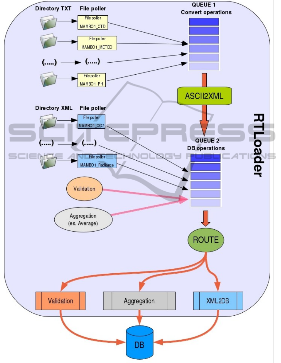
Figure 1: Figure showing the internal workflow of the RTLoader component.
A(Near)Real-timeValidationandStandardizationSystemTestedforMAMBO1Meteo-marineFixedStation
417

schema. We have decided to adopt these schemata
because they allow to fully describe data from all
sensors of our interest and to fulfil standardization
requirements enabling interoperability among
different data providers.
The use of Java language guarantees the platform
independence.
The resilience of RTLoader application is
obtained adopting a new approach using “Apache
Camel” as rule-based routing and mediation engine
operating in an event driven way, decoupling
software services, in a Java environment. This
framework is responsible for the quality of the
service features such as message persistence,
guaranteed delivery, failure handling, and
transaction support.
The data structure coming from the storage in a
relational database allows wide data-warehouse and
analysis (data-mining) opportunity, granting
capability to reach a wide end-user-needs spectrum.
Inspired by its European working experience the
Italian NODC is building, in collaboration with
other OGS groups, this technological infrastructure.
At the moment the work is following the needs
coming from the management of the already existing
meteo-marine monitoring network of the Regional
Civil Protection. The data comes from a wide range
of instruments like: meteo-oceanographic buoys
with a meteorological station and a CTD profiler,
directional waverider buoys with a satellite
positioning systems. We aim to increase the data
types covered. Within this perspective,
interoperability of the infrastructure is a pillar for the
system development.
3.1 Database Structure
The relational database used to store observation
from the buoy contains several tables (more than
30).The structure of the database was branched in
three parts:
1. The sector dedicated to describe the
instruments, their characteristics and their
position (DEPLOYMENT);
2. The section used to store data and related
metadata (MEASURES);
3. The part reserved to collect the vocabularies
used to standardize data and metadata and the
quality control (COMMON VOCABULARIES
and QUALITY CONTROL).
3.2 RTLoader
The Java framework “Apache Camel” guarantees
the possibility to manage the sequences, the queues
and the end of the process.
Starting from XML standard, defined by the
“JAXB” (Java Architecture for XML Binding)
application that convert the XML files in Java
classes, we have the opportunity to move toward an
object language.
This permits to move from a multitude of files
formats (ASCII) into a unique common format by
defining an XML file for each file format. The
framework “ServingXML” is used to re-build the
data into a standardized XML file using an
appropriate schema.
This XML file, that represents the first step for
inserting data, is converted by “JAXB” into an
object language. The framework JAXB transforms
the XML input file into java objects.
Therefore, the software “XML2DB” converts
XML input into java objects and then inserts the
measurements and the associated metadata into the
database. Before storing data, it obtains some
information from the database about the position and
the instrument used.
This workflow needs to be checked by a
controller that permits to manage automatically the
input files, as soon as they are created or updated. In
this system, this role is carried out by “Apache
Camel”, which checks constantly the presence of
new files (or eventually the presence of updated
files) and launches the conversion and the insertion
of data into the database.
3.3 DBValidator
Once the data have been included in the database, a
validation procedure (data quality control procedure)
is applied to the information to qualify the data
values (Giorgetti et al., 2007a), (Giorgetti et al.,
2007b). The procedure has been developed
following the European protocols (SeaDataNet,
2010), (UNESCO, 2010) eventually tuned to the
regional statistics (Manca et al., 2004). As a result of
the validation process, a quality flag is defined for
all checked information (in the data and in the meta-
data) without changing or eliminating any data
points. The quality control flag (UNESCO, 1990) is
a number associated to each measurement field,
whose value grows according to the importance of
the failure (0=not controlled, 1=correct, 2=suspect,
3=dubious, 4=wrong, 5=changed, 9=missing).
The quality control procedure implemented for
Mambo meteo-oceanographic data includes the
following series of automatic checks:
- checks for missing data and data format
completeness;
SENSORNETS2014-InternationalConferenceonSensorNetworks
418

- check of the date/time and of the measuring
position;
- check of duplicate vertical profiles or measures;
- check for spikes by testing data for large
differences between adjacent values,
- check for invalid values by comparison with min &
max values fixed for each parameter archived.
These checks are implemented at fixed time
intervals to series of three data points and aim at
highlighting:
- the presence of casual errors, that may be due to
unhappy manual operations, to voltage drop during
measurements, to data transmission problems, to
sensor calibration problems, to ordinary or
extraordinary maintenance operations;
- the presence of systematic errors, that may be due
to changing of measuring routine operations,
changing of instrumentation, changing of the
measuring site or changing of environmental
conditions at the site.
3.4 RTWs and RTWeb
RTWs is a RESTful Web Service that accepts
simple requests to extract the data from the database.
These requests can be parameterized with temporal
range and the output format. The Web Service
interface RTWeb can be accessed at the URL
“http://nodc.ogs.trieste.it/rtws/application.wadl”. It
is written using Java and open source libraries like
Spring and Jersey.
The Web interface allows the selection of data
parameters. It is mandatory to specify the temporal
interval. The Web interface collects the criteria
specified by the user, and calls the Web Service
RTWs to create the result with the data matching the
user’ criteria.
3.5 RTSOS
Recently, real-time observations of few sensors have
been published by an OGC SOS and descriptions of
different sensors can be discovered or compared
using OGC SensorML standard requests (e.g.
DescribeSensor()). Observations are stored in a
PostgreSQL/PostGIS database, they can be obtained
by standard requests (GetObservation()) and geo-
located by GetFeatureOfInterset(). Finally, in order
to access observations,an SDI client displays on a
Web interface the sensors position, their observed
properties and long term trends of observations. It
has been implemented using JavaScript toolkits
(OpenLayers, GeoExt and ExtJS).
A similar approach has been adopted by other
Italian research organizations managing marine
observation from fixed stations and proved to be
feasible and promising (Oggioni et al., 2013).
4 RESULTS AND CONCLUSIONS
MAMBO1 meteo-marine fixed station, managed by
OGS, is operating since 1998. It has been recently
included into the joint European research
infrastructure network for coastal observatories,
giving a strong boost to the harmonization of the
real-time validation and standardization procedures.
The main objective of the approach presented in this
paper is data sharing. The added value is the
complete description of the operations carried out on
the sensors and the data themselves (both in the
acquisition phase and in the subsequent management
of information with quality control). Our
technological choice is led by the requirements of
interoperability and resilience. A software package
including the Sensor Observation Service (SOS)
installed for selected sensors of the (near) real-time
monitoring system has been developed within the
RITMARE Italian Flagship and installed at OGS
premises. The SensorML used is compliant with the
international standards and developed results as a
joint effort of the Italian RITMARE, the European
SeaDataNet, Eurofleet and ODIP community. The
adoption of SWE (Sensor Web Enablement)
standards allow as a direct consequence the
integration of platforms to be effectively managed in
a multi-channel and multi-platform way. The
resulting data set is publicly available and can be
progressively integrated into a distributed
infrastructure, capable to manage real-time data
acquired by different observation systems (from
fixed sites for sea observation, multiplatform
observatories, autonomous tools, to eventually
remote sensing data).
ACKNOWLEDGEMENTS
This work was supported by the Ministry of
Education, Universities and Research (MIUR) under
RITMARE Flagship Project. We also acknowledge
funding from the European Union Seventh
Framework Programme (grant agreement n° 123456
JERICO and grant agreement n° 283607 SeaDataNet
II) and from the Friuli Venezia Giulia Region –
Regional Civil Protection (contract n° 17/CD2/2009
A(Near)Real-timeValidationandStandardizationSystemTestedforMAMBO1Meteo-marineFixedStation
419

PALME4). Operations at sea are coordinated and
constantly performed by OGS TecDev Research
Unit, while the maintenance of the instruments is
followed by the Calibrations & Testing Operations
Group (OGS CTO Group).
REFERENCES
Brosich A., Altenburger A., Giorgetti A.: Software
RTLoader - Manuale Utente. Rel. 2013/43 Sez. OCE
21 NODC.
Giorgetti A., Brosich A. and Mosetti R.: OGS
oceanographic data archiving and validation system:
the IOC/National Oceanographic Data Centre, Boll.
Geof. Teor. Appl., 48 (3) (2007), pp. 359-369.
Giorgetti A., Inghilesi R., Orasi A., Morucci S., Bruschi
A.: Maritime data standardization in the Archimede
Project, Boll. Geof. Teor. Appl., 48 (3) (2007), pp.
305-317.
Manca B., Burca M., Giorgetti A., Coatanoan C., Garcia
M.J. and Iona A.: Physical and biochemical vertical
profiles in the Mediterranean regions: an important
tool to trace the climatology of water masses and to
validate incoming data from operational
oceanography. J. Mar. Sys., 48 (2004), pp. 83-116.
Oggioni A., M. Bastianini, P. Carrara, F. Pavesi,
“Condivisione di dati real time tra sensori di Istituti
del CNR: un approccio possibile”, 17a Conf. Naz.
ASITA, Riva del Garda, 5-7 novembre 2013, pp. 1047-
1054.
SeaDataNet: Data Quality Control Procedures, Version
2.0, May 2010, 78 pp.
UNESCO: GTSPP Real-Time Quality Control Manual,
IOC Manuals and Guides n. 22. In: Manual of Quality
Control Procedures for Validation of Oceanographic
Data. CEC: DG XII, MAST and IOC: IODE Manual
and Guides n. 26 (1990), pp. 305-432.
UNESCO: GTSPP Real-Time Quality Control Manual,
First Revised Edition. IOC Manuals and Guides No.
22, Revised Edition. (IOC/2010/MG/22Rev.) (2010),
145 pp.
SENSORNETS2014-InternationalConferenceonSensorNetworks
420
