
Integrating Various Cloud Computing Services in a Collaborative
Geo-referenced Learning Scenario
Nelson Baloian
1
, Gustavo Zurita
2
and Ulrich Hoppe
3
1
Department of Computer Sciences, Universidad de Chile, Santiago, Chile
2
Management Control and Information Systems Department, Universidad de Chile, Santiago, Chile
3
Department of Computer Science and Applied Cognitive Science, Faculty of Engineering, University Duisburg-Essen,
Duisburg, Germany
Keywords: Collaborative Learning, Cloud Services, Software Architecture.
Abstract: Some of the main characteristics of Cloud Computing are reliability, scalability and ubiquity. This makes it
especially suitable to support large groups on learning activities that require computer support in various
settings, in and outside the classroom. In this work, we first analyze the use of Google Maps for supporting
a learning activity in an urban environment, concluding that some important features are missing. We then
propose an approach for taking advantage of cloud computing services for learning activities by integrating
different services in a new application.. A general architecture explaining this approach and a design for
such an application as example are finally presented.
1 INTRODUCTION
Cloud computing, in all its modalities, is
increasingly being used to support collaborative
learning activities, especially for those involving
large groups (Antunes et al., 2011), since scalability
is one of the most prominent characteristic of it.
According to (Tan and Kim, 2011), the benefits
of using cloud computing to support learning are
following: cost saving, flexible IT management, and
accessible IT Resources and Services, because the
services they provide are accessible from any device
connected to the internet like desktop PCs, laptops,
tablets and smartphones.
On the other side, they point to some risks:
reliability, because vendors of cloud services will
never provide 100% reliability; control, since the
services reside and are controlled by the vendor;
security and privacy because the lack of control also
may lead to the risk of security or privacy breaches;
Organizational Learning, because users of cloud
services (students and teachers) might need to learn
a new way to interact with the software. Moreover,
in (
Masud and Huan, 2011) authors say that public
clouds may offer low-cost services, but in return
they may not provide needed assurances of security
for those services. They also refer to the need that
Software-as-a-Service (SaaS) has to be customized
to meet the needs of various customers. However,
providers cannot afford to develop and maintain a
version of application for each individual customer.
This work first presents an experience in which a
well known cloud service, namely Google Maps,
was used “as it is” in order to support students of a
pre-graduate university course about business and
TI, in which they had to propose, discuss and rank
ideas in which IT could be used in certain parts of
the city in order to solve problems or improve
citizens’ daily life. A questionnaire was applied to
the students in order to find out in which degree did
the software meet the needs for performing the
requested collaborative learning activity. Analyzing
the answers we found that they appreciated many of
the functionalities provided by the site.
However, they also pointed out to some
important drawbacks, such as the lack of private
workspace, security problems, delayed
synchronisation and the basic mechanisms for
supporting decision making: a public discussion
space and a mechanism to rank the solutions/ideas
they generated during this work. Based on these
results, we present here a new development, which
uses services from the cloud as building blocks for
developing an own application customized to meet
the needs of the particular leaning scenario involving
737
Baloian N., Zurita G. and Hoppe U. (2013).
Integrating Various Cloud Computing Services in a Collaborative Geo-referenced Learning Scenario.
In Proceedings of the 5th International Conference on Computer Supported Education, pages 737-744
DOI: 10.5220/0004455807370744
Copyright
c
SciTePress

a large group with the minimum effort,
programming only the “glue code” to integrate these
blocks and implement the missing functionalities.
The development has the following characteristics:
It uses de cloud computing services from Goggle
Maps in order to show maps and associate specific
data objects to certain geographical locations,
which represents the ideas proposed by the
students.
It uses the cloud computing services from Twitter
in order to implement students’ participation to
Rank ideas.
It uses Facebook Authentication services to
register and keep track of what students contribute
to the discussion.
Implements freehand writing and sketching over
the maps.
Implements on-time synchronism on the objects
which are created/modified on the map (sketches,
location marks, photos, comments, ideas ranking)
Stores the important data in an own server using a
XML format.
In this way we also address some of the problems
related to control and security inherent to cloud
services mentioned before. This approach has many
ideas in common with the one presented in (Jansen
et al., 2012), in which cloud services such as
Twitter, Facebook, even SMS and e-mail are used as
data input channel for various learning applications.
One of the main ideas we share is from the software
engineering point of view, which considers that
cloud services may be integrated into a new
application in order to reuse available, well
implemented and scalable functionalities.
2 RELATED WORK
AND DEFINITIONS
According to (Sultan, 2010), cloud computing is an
emerging computing paradigm which promises to
provide opportunities for delivering a variety of
computing services and that educational
organizations are already taking advantage of the
benefits.
According to (Alabbadi, 2011), cloud computing
will significantly impact the educational and
learning environment. They propose the use of cloud
computing in the educational and learning arena, to
be called “Education and Learning as a Service”
(ELaaS).
Some studies explored specific cases where
Google Document, Google Presentation, and Google
Maps are used to facilitate collaboration in learning
contexts. In (O'Broin and Raftery, 2011) authors
explored how Google Docs overcome some
limitations in project-based learning. They report
that work with project-based learning has limitations
related to students’ difficulty to collaborate on
artifacts outside the class, and that it is problematic
for the teacher both to monitor the progress of the
project, and to assess the individual contribution of
each student. Authors say these limitations are partly
overcome by Google Docs, because: (1) it enables
students in different locations to work
simultaneously but independently on the same
artifact; and (2) teachers can be included as
observers on each project group and thus track the
development of the work. However, students also
identified some limitations of simultaneous editing
of Google Docs: if two or more students edit text in
the same region of a document, one of the students
will receive a message informing the student that
his/her text has been discarded, spontaneous
deletions of text, and confusion caused by the auto-
save feature.
Cloud computing for learning environments has
different groups of stakeholders, with different
information needs (Masud and Huang, 2011):
students rely on IT for communication and
information searching; teachers pervasively utilize
IT to deliver individual or collaborative task (e.g.
using Google Docs, Google Maps, etc.), lectures,
manage course materials, and provide speedy
feedbacks to students; administrators use IT-based
information systems to manage registration, human
resource, and accounting. A case study methodology
was applied, in order to investigate the use of
Google Docs as a free cloud computing based
product (Masud and Huang, 2011). The results
obtained indicate that MBA students held positive
impact on perceived usefulness and satisfaction
about using Google Docs. In (Kumar, 2009) authors
report that undergraduates students found that
Google Docs helped them to complete large amounts
of work online by allowing them all to work on a
document without need to meet all at the same time.
In (Chu and Kennedy, 2011), Chu and Kennedy
describe an experience about using MediaWiki and
Google Docs at undergraduate level as online
collaboration tools for co-constructing knowledge in
group project work. Students used MediaWiki for
project during a knowledge management course and
Google Docs for completing a final year project.
Results indicated that some of the students had
positive experiences using the tools for online
collaboration in the group projects. According to this
CSEDU2013-5thInternationalConferenceonComputerSupportedEducation
738

report, MediaWiki and Google Docs gave teachers
the facility to closely monitor student progress, and
provide feedback to assist in the effective
management of the report-writing process. Thomas
(Thomas, 2011) also explores the potential of cloud
computing in an educational setting using Google
Docs.
Fluke reports a pilot study on the use of Google
Maps to provide virtual field trips as a component of
a wholly online graduate course on the history of
astronomy (Fluke, 2008). The Astronomical Tourist
Web site (ATsite) is an example of how Web 2.0
applications (mash-ups) can be used to build new
online learning environments. The use of Google
Maps was used to support virtual field trips. It
helped to clarify and strengthen the connection
between the places and people involved. Students
could share their experiences visiting locations,
personalizing the learning experience. By
encouraging students to seek out locations active
learning was undertaken.
From the literature review, we can conclude that
free cloud services offered by various providers have
been used to support learning activities. Most cases
report that the cloud service was used “as it is”,
except for (Fluke, 2008) and (Jansen et al., 2012), in
which APIs of different cloud services were used in
order to create a new application. In this work, we
intend to systematize this approach in order to
develop learning applications combining various
services offered by the cloud and integrating them in
a new learning application.
3 EVALUATING GOOGLE MAPS
“AS IS”
As seen from (Fluke, 2008), learning can benefit
from making use of the services provided by Google
Maps, especially those in which the knowledge to be
acquired is related to information with a strong
association to a geographic place. Other examples
are described in (Otaga et al., 2006) and (Zurita and
Baloian, 2012). In our case, we decided to first
make an experiment in order to have some insight
about the suitability of Google Maps to support
certain collaborative learning activity involving a
large group of students.
We used the same methodology, experiment
design and applied a similar questionnaires in the
work reported in (Antunes et al., 2011). However,
the results were analyzed for a different purpose: this
time the focus was to find out which functionalities
were missing or not properly supported to
accomplish the task.
The experiment involved students from an
undergraduate course undertaking a collaborative
design assignment to identify problems and/or
opportunities in a urban area and propose innovative
solutions based on information technology. They
were asked to accomplish the assignment using
Google Maps. This assignment was given during the
second semester of 2012. The sample consisted of
46 students, 28 male; average age 22.3, taking an
undergraduate course on Computer Science, in the
eight semester of Information and Management
Control Engineering, at Universidad de Chile. It is
expected that students at the end of the course are
able to: (a) detect problems and identify
opportunities in an organization, that may be
supported through IT; (b) manage an IT strategy that
can introduce competitive advantages into an
organization; (c) design IT solutions; and (d)
develop communication and teamwork skills. These
students were good users of computing technology
because 35% use notebooks or tablets in classes and
most have smartphones, all use PC at home. They
regularly use popular desktop software; and use
social media tools like Twitter, Facebook and MSN.
The task was performed collaboratively outside
regular classes. All students were part of a single
team. The teacher explained the task in the
classroom, recommending the students to observe an
area and identify problems, opportunities and ideas
that may be addressed using IT, which should be
geo-referenced in Google Maps. Each student should
deliver at least two ideas. Students were also asked
to discuss and give their opinions on the classmates’
ideas and collaboratively choose the ten best by
mutual agreement. Students had one week to
perform the task. No instruction regarding the type
of hardware to be used or the coordination
mechanism to select the best ideas was given. They
were just told they should use Google Maps.
Consensus rules, task awareness and coordination
mechanisms had to be established by the students
themselves.
Following the instructions, students performed
the task accordingly. Most pictures were taken
with mobile phones and uploaded in Google Maps
later. The resulting documentation of the activities
done with Google Maps may be seen in Figure 1.
The students filled in questionnaire with three
questions: (Q1): “did you feel information overload
during the task?”, (Q2) “how easy was the software
itself to use”, and(Q3) “how easy to use was the
collaboration
support?” Students were asked not
IntegratingVariousCloudComputingServicesinaCollaborativeGeo-referencedLearningScenario
739
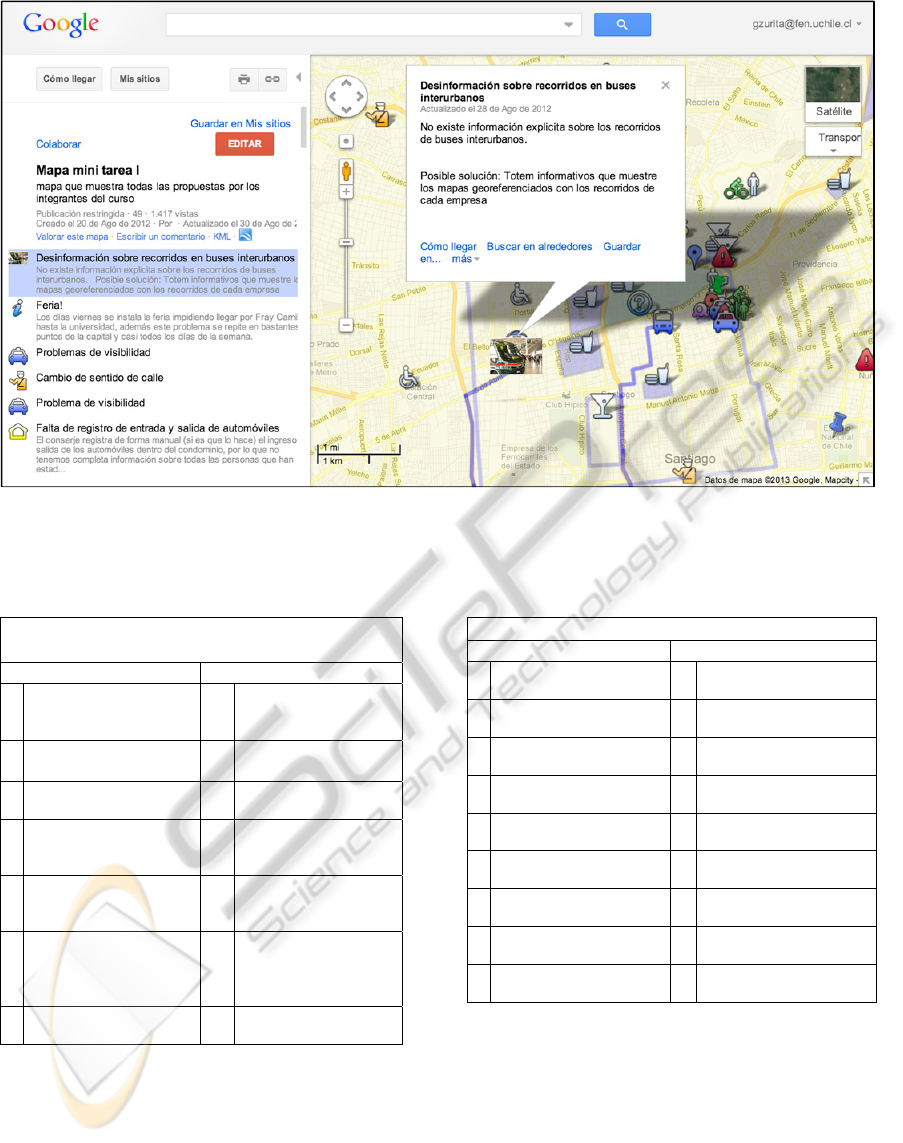
Figure 1: A Google map collaboratively geo-referenced by the students. On the left side, the list of problems, ideas and
comments are shown. Geo-references are displayed as icons on the map representing the location for these ideas.
Table 1: the positive and negative comments associated
with the Q1.
Q1: Did you feel information overload during the
task ?
Positive comments Negative comments
2
Everyone was available
on the computer screen
1
9
Too many ideas and
comments shown at
the same time
1
Work was performed
orderly
6
Some contributions
were duplicated
1
History of ideas was
easy to follow
2
Considerable flow of
ideas and feedback
6
Relation between
ideas and comments
difficult to establish
7
Related ideas are
shown apart from
each other
2
Too many objects
shown in the same
window at the same
time
2
Some comments were
simply forgotten
only to give a quantitative answer but also mention
positive and negative aspects of the software related
to the question. The results are shown in Tables 1, 2,
and 3.
The comments to Q1 indicate that the flow of
ideas was very high, making it difficult to follow and
easy to forget. Also, the number of repeated ideas
was
considered high. Very few comments were
Table 2: the positive and negative comments associated
with the Q2.
Q2: how easy was the software itself to use?
Positive comments Negative comments
1
0
Easy to understand 8
Proximate comments
are difficult to discern
3
Immediate visualization
of new comments
6
Cannot see who deleted
comments
2
Reference of ideas in
geographical context
7
Lacks coordination
support
2 Using of colors 6
Mapping and chatting
unrelated
2
Using of text and
pictures
2 Slow
1 Use of icons 2
No private working
space
1 Easy access to ideas 1
Had to improvise in
order to collaborate
1 Searching 1
Difficult to merge
comments, ideas
1
Communication is not
primarily focus
given on the positive side. The most relevant
observation was that the participants liked having all
information visible on the computer screen.
Comments to Q2 reveal several technical issues
contributing to the perceived low usability. The most
frequently cited one is a usability problem related
with uploading photos. Two other ones concern
difficulties discerning comments when their
locations
are
very
proximate,
and
lack
of information
regarding who deleted others’ comments.
CSEDU2013-5thInternationalConferenceonComputerSupportedEducation
740
Within the collection of negative factors, we also
find references to more conceptual problems
regarding the task organization. In particular, the
participants pointed out a disparity between mapping
and commenting ideas, the fact that communication
is not the primary focus of Google Maps, and the
need to improvise collaboration strategies, since the
tool does not offer clear support in that area.
Table 3 reveals a large set of negative and
positive factors regarding collaboration support,
although with clear emphasis on the negative side.
Within the negative factors, two of them were very
preeminent: the group had to develop a coordination
mechanism (using Google Docs) since the tool does
not provide a native solution; and the problem that
any participant may modify or delete comments
without control or rollback. Within the positive
factors, the most significant ones were the support
for sharing ideas, obtaining and giving immediate
feedback about the ideas, and asynchronous
interactions. Students also mentioned that besides
having to devise an alternative scheme to collaborate
they also had to designate a facilitator.
Table 3: the positive and negative comments associated
with the Q3.
Q3: how easy to use was the collaboration support?
Positive comments Negative comments
4 Shared view of ideas 14
Group had to develop
alternatives for
coordinating group
work
1
Easies problem
understanding
12
Users can edit others’
contributions
1
Facilitates view of task
progress
7
Tool inadequate for
discussion support
2
Permits asynchronous
interaction
1 Difficult to converge
1
Easies time
management
1
Asymmetric
participation
1 Uses colors 1 Lack of chat tool
1
Lacks awareness
mechanisms
4 PROPOSAL
FOR AN INTEGRATED
APPLICATION
In (Tan and Kim, 2011) authors state that the match
between the attributes of a particular technology and
the characteristics of the tasks to be supported by
this technology is one of the critical success factors
in IT adoption and implementation. Based on the
comments given by the students about the missing
functionalities we propose in this chapter (1) a
general architecture for developing applications to
support learning activities for large groups
integrating cloud services; (2) a new application
based on this architecture, which implements most
of the functionalities that were considered important
but were not provided by Google Map “as is”.
4.1 A General Architecture
The starting point for our proposal is the SOA
approach for software development and the
conceptual basis elaborated in (Jansen et al., 2012),
essentially an architecture that takes advantage of the
already existing “cloud services” for collecting inputs
and in this way achieves an improved “accessibility”
of the overall system. Our approach here goes one
step further by proposing that various cloud services
could be used not only for facilitating data input in a
convenient way but also for other functionalities. In
the particular case of systems for situated, location-
dependent learning activities based on geo-
collaboration we see at least the following additional
functionalities to be integrated using available cloud
services:
Maps: Maps are an important element for many
applications supporting field trips. Today they can
be downloaded from various sources: Google
Maps and Open Layer offer 2D maps, Google
Earth offers 3D maps. They offer APIs in order to
download and manipulate maps.
Authentication: Many learning activities require
identifying the student who generates learning
material or performs an activity. Google’s or
Facebook’s authenticator may be used to
incorporate this functionality in a new application.
Discussion board: Social networks like Twitter or
Facebook, as well as other Cloud Services may be
used to implement the input text for these
facilities.
Synchronization: Real time synchronization of
data is frequently necessary. Cloud Services like
Google App engine, Microsoft Window Azure or
Amazon's Elastic Compute Cloud could be
interesting platforms to be considered for
implementing this part of the system.
Data storage: For this, there are many possibilities
which offer APIs to store data in varied formats:
Amazon S3, Apple iCloud for Cloud storage
service, Dropbox for files, Google Storage , KIT
Video API among many others.
IntegratingVariousCloudComputingServicesinaCollaborativeGeo-referencedLearningScenario
741
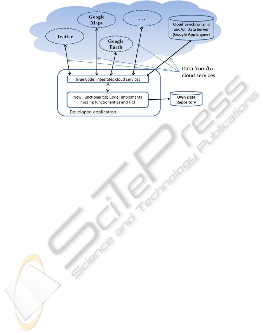
Figure 2: The picture shows the logical general schema of the proposed architecture.
Figure 2 shows a logical schema of the proposed
general architecture for supporting geo-collaborative
learning activities with key functionalities provided
through cloud services. The new application has a
“glue–code” component implementing the
communication with the cloud services through their
APIs by sending and receiving data and/or invoking
functions. This part also interacts with the code that
has been developed in order to implement additional
functionalities not provided by the cloud services,
including the user interface. This part of the code
may also in some cases implement functionalities for
data storage in an own server or repository in the
case that available Cloud Services may not match the
requirements needed. This can, for example, be due
to the data format, or because the data to storage may
be sensitive (priovacy). In order to guarantee a
maximum portability of the developed applications,
our approach proposes to develop the applications
using HTML5 and JavaScriptas a common
deniominator between a variety of platforms,
including desktop PCs running Windows or Unix,
tablets and smartphones running Android as well as
iPads running iOS. With its new features, HTML5 is
capable of implementing rich interactive applications
running on a browser (Baloian et al., 2011).
4.2 A Reference Architecture
According to the students’ comments, some of the
problems were related to the lack of coordination
and awareness mechanisms. For this reason, it was
difficult to keep track of the work process. To
overcome this problem, we first propose that
students should be individualized in order to
associate their contribution to their login name and
establish an authorship property for these
contributions. This may be accomplished by the
authoring services in Facebook, since Facebook also
provides the functionalities for implementing
discussion boards with non-anonymous
contributions.
Another coordination problem was the lack of a
mechanism allowing to rank the ideas and
suggestions. For this we propose to integrate the
like/dislike of twitter, since is a well know
mechanism and it is easy to integrate. Facebook
offers a similar functionality. We select Google
Maps in order to integrate the maps because of the
simplicity of the tasks that need to be accomplished.
Google maps also provide api services: routes,
distances, elevations, geocoding and places. Thus
the “glue code” implements the conversation with
Facebook, Twitter and Google Maps through their
APIs and renders the graphical elements received
from the services. Additional code has to be
developed in order to implement private and public
workspaces as well as switching between them and
passing data from the private to the public
workspace. Due to the characteristics of the data
generated by the system and related privacy issues, it
is not possible to use an external cloud service for
sorage, so a specific dedicated server has to be used.
For the same reason, it is also impossible to
implement the synchronization of data for the public
workspace with an external service. This will be
implemented using a mechanism developed earlier
by the authors which allows easy synchronization of
CSEDU2013-5thInternationalConferenceonComputerSupportedEducation
742
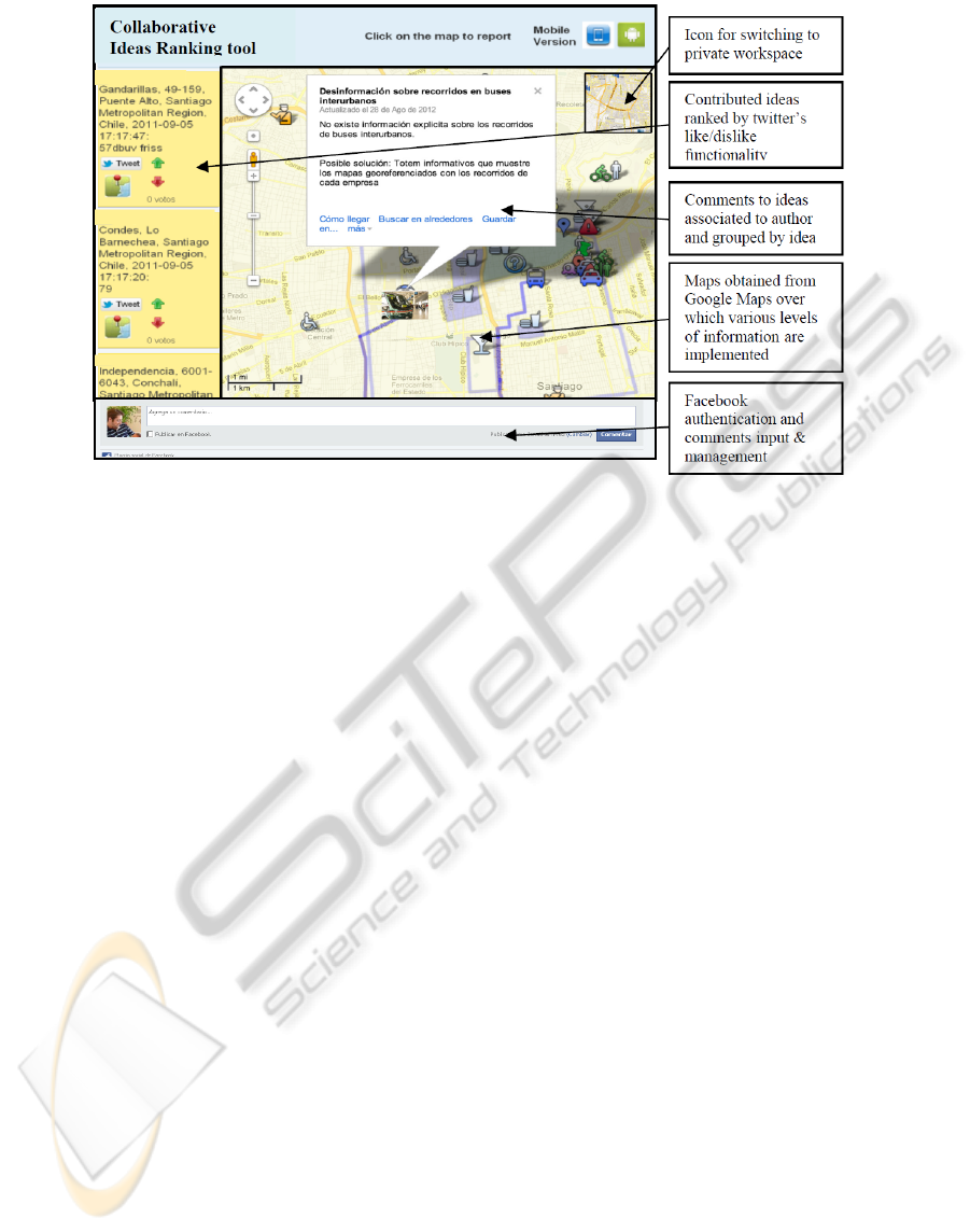
Figure 3: Mock-up of the interface for the proposed application.
applications developed in HTML5 called “couple
objects” [15].
5 CONCLUSIONS
Some of the main advantages that authors have
mentioned about Cloud Computing are scalability,
ubiquity, and reliability. These characteristics match
the requirements of many learning scenarios,
especially those in which students have to perform
learning activities across various setting, inside and
outside the classroom, collaboratively and
individually working on generating and analyzing
data, using different kind of computing devices
supporting this work. This work proposes the use of
cloud computing for learning in a different way as
reported by the literature: instead of using services
as they are offered we propose to combine them in a
new application which can be tailored to meet the
requirement of a specific learning activity taking
advantage of the characteristics of cloud computing
and getting rid of at least some of its drawbacks.
We first analyzed the potential of using a popular
cloud computing service to support a collaborative
learning activity with a large group of students,
understanding large by more than 20 individuals.
Although Google Maps was able to provide a
number of functionalities required to accomplish the
task, it was clear that student missed other
functionalities which would have helped a lot. This
leads us to the idea that cloud services could be
combined and integrated in a new application
tailored especially for the learning requirements
saving considerable development efforts. We present
this idea as architecture for developing applications
using this approach. Based in this, we present a
preliminary design for an application which matches
the requirements for this learning activity including
the missing ones. The feasibility of this approach has
been already proved by previous applications
implementing this approach to some extent (Jansen
et al., 2012); (Baloian et al., 2011).
REFERENCES
Pedro Antunes, Antonio Ferreira, Gustavo Zurita, Nelson
Baloian. Analyzing the Support for Large Group
Collaborations using Google Maps. Proc. 15th
Computer Supported Collaborative Work in Design
(CSCWD), pp. 748-755, Jun 2011. Lausanne,
Switzerland.
Tan, X., Kim, Y.: Cloud Computing for Education: A
Case of Using Google Docs in MBA Group Projects.
In: Proceedings of 2011 International Conference on
Business Computing and Global Informatization
(BCGIN), pp. 641–644 (2011)
Masud, A. H., Huang, X.: “ESaaS: A New Education
Software Model in E-learning Systems”, Information
and Management Engineering Communications in
Computer and Information Science, 2011, 235 (1), pp
468-475. (2011)
Jansen, M., Bollen, L., Baloian, N., Hoppe, H. U.: Cloud
Services for Learning Scenarios: Widening the
Perspectives. In: Proceedings of the 1st International
IntegratingVariousCloudComputingServicesinaCollaborativeGeo-referencedLearningScenario
743

Workshop on Cloud Education Environments,
Antigua, Guatemala, November 15-16, pp. 33-37.
(2012)
Sultan, N. "Cloud computing for education: A new
dawn?" International Journal of Information
Management 30(2), pp. 109-116. (2010).
Alabbadi, M. M. Cloud computing for education and
learning: Education and learning as a service (ELaaS).
Interactive Collaborative Learning (ICL), 2011 14th
International Conference on, IEEE. (2011).
O'Broin, D., D. Raftery. Using Google Docs To Support
Project-Based Learning. AISHE-J: The All Ireland
Journal of Teaching and Learning in Higher Education
3(1). (2011)
Kumar, S. Undergraduate perceptions of the usefulness of
web 2.0 in higher education: Survey development.
Proceedings of the 8th European conference on e-
learning. (2009).
Chu, S. K. W. and D. M. Kennedy (2011). "Using online
collaborative tools for groups to co-construct
knowledge." Online Information Review 35(4): 581-
597
Thomas, P. Cloud computing: A potential paradigm for
practicing the scholarship of teaching and learning.
The Electronic Library, 29(2): 214-224, (2011).
Fluke, C. J. (2008). "Virtual field trips: Using Google
Maps to support online learning and teaching of the
history of astronomy." Astronomy Education Review
7: 74
Ogata, H., C. Yin, R.G.P. J., N.A. Saito, Y. Yano, Y.
Oishi, & Ueda, T. (2006). Supporting Mobile
Language Learning outside Classrooms, in Procs.of
IEEE International Conference on Advanced Learning
Technologies. ICALT 2006: Kerkrade, Netherlands. p.
928-932.
Gustavo Zurita, Nelson Baloian. Context, Patterns and
Geo-collaboration to Support Situated Learning.),
Proc. 6th International Conference on Ubiquitous
Computing and Ambient Intelligence (UCAmI), pp.
503-511, Dec 2012. Vitoria-Gasteis, Spain.
N. Baloian, J. Frez, M. Jansen, G. Zurita: The Role of
HTML5 in Mobile Situated Learning Scenarios,
Proceedings of the 1oth world conference on Mobile
and Contextual Learning, Beijing, China, 18-21
October 2011.
CSEDU2013-5thInternationalConferenceonComputerSupportedEducation
744
