
Integra System
João C. Ferreira
1,3
, Porfírio P. Filipe
1
and Paulo M. Martins
2
1
ADDETC-ISEL, Lisbon, Portugal
2
ADEC-ISEL, Lisbon, Portugal
3
Centro Algoritmi, Univerdidade Minho, Guimarães, Portugal
Keywords: Public Transportation, Data Integration, Sustainable Mobility, Car Sharing, Bike Sharing, Mobile System.
Abstract: The current work deals with the scenario of growing population in the cities and the associated sustainable
mobility problems. To address this issue it was developed a computational system called INTEGRA, ready
for mobile devices, based on the integration from heterogeneous data sources such as multi-modal public
transportation systems, car and bike sharing. This system is able to show and give guidance towards points
of interests (POI) and promote a social collaborative network sharing annotations about sustainable mobility
options. This work is a contribution for the European Project START. The project’s goal is to make travel
easy and sustainable improving the quality of information provided to travellers. This goal is shared by
transport operators and authorities associated to the Integra registered brand, promoted by the START
consortium, that is already prepared for UK, France, Spain and Portugal.
1 INTRODUCTION
There is difficulty in obtaining information about
traveling to, from and within a region, even in the
same city, due to the diversity of transportation
operators. Most of these operators have their own
system, so that they work and plan the routes and
schedules independently of nearby operators. Also
public transport systems differ from region to
region. It is therefore understandable that when
reaching a destination, even for the most traveled
user, it becomes difficult to use local public
transport due to poor organization of information,
and especially due to language barriers, for those
who do not speak the native language of the country.
In this context, is denoted the scarcity of appropriate
information systems to assist travelers in the region,
including providing practical information, essential
to understand the operation of the means of
transportation.
The availability of the Internet and the current
development of Information and Communication
Technologies (ICT), became the best way to
disseminate information, inspiring the development
of strategies to support tourism and culture.
Additionally, the mobile guides are increasingly
seen as an asset to offer an experience more
appealing of visitation and interpretation to natural
parks or historic sights. Technological advances
allow higher processing in smaller devices, making
possible the use of technologies such as GPS and
Wi-Fi. In addition, the popularity of social networks,
like Facebook, showed the willingness of users to
share their experiences and be part of communities
with similar interests.
Part of this research work was used in ISEL
participation on the Seamless Travel across the
Atlantic Regions using sustainable Transport
(START) project. START Project is a European
Commission’s Transnational Territorial Cooperation
Programme with 14 partners from the UK, France,
Spain and Portugal. The main mission is the
establishing of a transnational network of regional &
local authorities to promote enhanced accessibility,
giving tools to make easy to travel to, from, and
around the Atlantic regions, using environmentally
friendly, collective modes of transport, greater
interconnectivity between transport systems, clearer
information within regional gateways, airport hubs
ports and rail interchanges. For more information
see (http://www.start-project.eu).
Main contribution of ISEL on this project was
the data integration of multiple transportation
sources (Costa, 2010), a system to support user on
public transportation query data and a Car and Bike
sharing System (Xavier and Lourenço, 2011). The
57
C. Ferreira J., P. Filipe P. and M. Martins P..
Integra System.
DOI: 10.5220/0004342400570064
In Proceedings of the 9th International Conference on Web Information Systems and Technologies (WEBIST-2013), pages 57-64
ISBN: 978-989-8565-54-9
Copyright
c
2013 SCITEPRESS (Science and Technology Publications, Lda.)
INTEGRA system should allow the interrogation of
multiple sources of information through a single
interface. The questions and answers to them should
reflect a single data model. The existence of a single
common data model takes the client applications
with the difficult task of dealing with various
technologies and their relational schemas different.
Different public transportation systems can be added
with total transparently to the end user. From
START project different public transportation data
and data base schemas were tested. Also this
integration allows the creation of mobile systems
oriented for tourisms purposes, other main goal of
START project, where “low budget tourism” can be
guided, to reach POI (Points of Interest) by public
transportation, look and reserve parking slots.
2 PUBLIC TRANSPORTATION
INFORMATION INTEGRATION
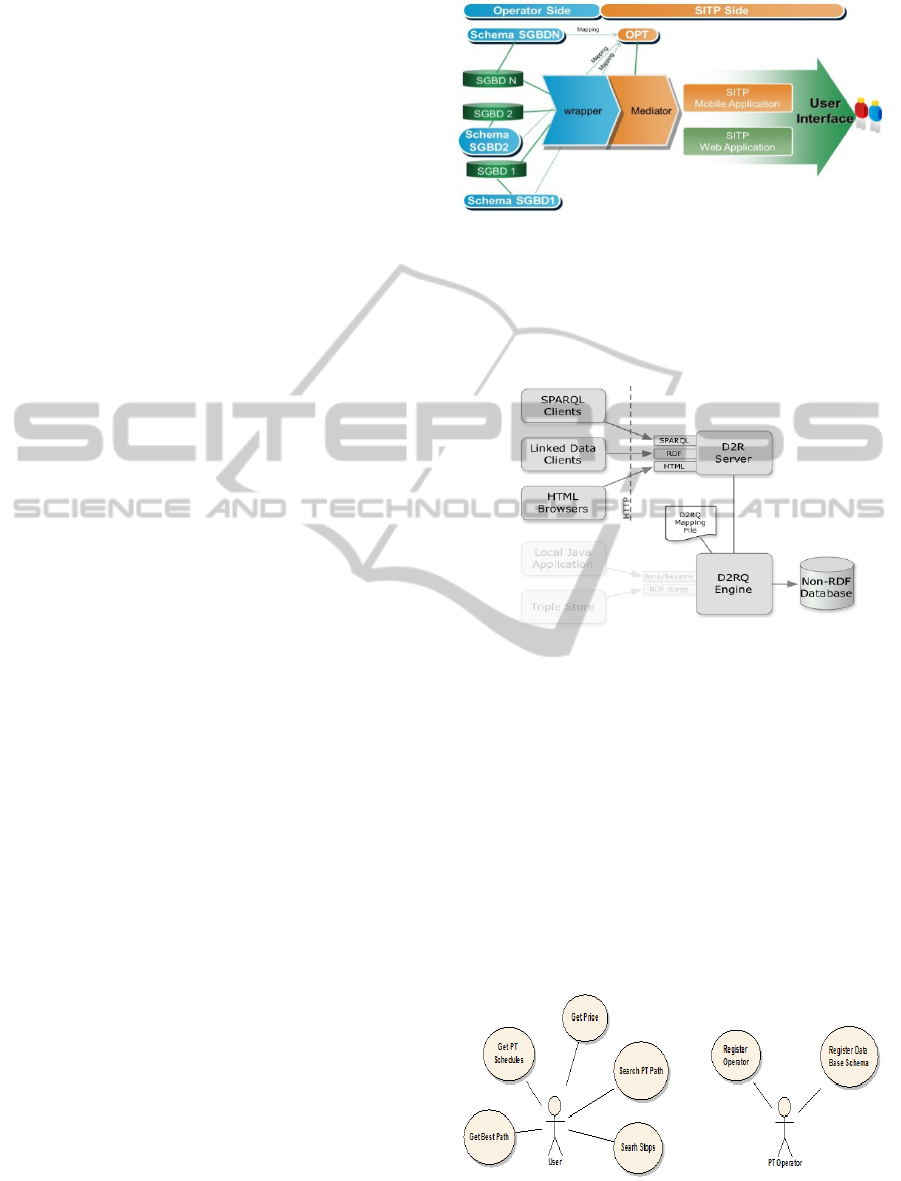
In Figure 1 is illustrated the public transportation
different sources data integration approach, where is
possible data information integration from different
operators of public transportation. This application
output is a user Mobile Device, or Web Application
SITP, that is described in Section 3. The data
integration is based on a domain ontology (Ontology
for Public Transportation - OPT) (Ferreira et al.,
2011a), a wrapper that performs the mapping
between different public transportation data base
models and a mediator. If the public transportation
operator data base is constructed under OPT the
wrapper and the mapping definition are not needed.
Wrapper is developed at each operator side based on
operator information source and is a common
interface for data access. In Figure 2 is presented the
wrapper solution based on (Bizer, 2009). D2RQ is a
declarative language to describe mappings between
relational database schemata and OWL/RDFS
ontologies. The D2RQ Platform uses these mapping
to enable applications to access a Resource
Description Framework (RDF) view on a non-RDF
database through the Jena and Sesame APIs, as well
as over the Web via the SPARQL Protocol and as
Linked Data.
SGBD Schema Publication is the mapping
process between local data base and the vocabulary
of the ontology (OPT) using R2RQ language. The
Process is divided in the following steps: (1) entity
definition; (2) adding of proprietaries to the entities;
(3) connection of entities; and (4) definition of
conditions and aggregations (when necessary).
Figure 1: Different Sources of Public Transportation Data
Integration Approach.
Mediator is based on MediaSpaces Mapping
Framework, where it is possible to perform
SPARQL queries based on OPT.
Figure 2: Platform D2RQ used at Wrapper Components.
3 SITP APPLICATION
SITP is the application to handle public
transportation information in a mobile or web
application and is part of Integra system. In Figure 3,
is illustrated a typical client operation from the client
side: search for stops, search information of public
transportation for a certain path, get price, schedules
and best itineraries path options. From the operator
are showed the registration and the registration of
DB schema.
Figure 3: Use Case for SITP Application.
WEBIST2013-9thInternationalConferenceonWebInformationSystemsandTechnologies
58
Two Web applications were developed:
• SITP, to support queries from users;
• SITP, for the management of information by the
public transportation operators.
These applications were implemented in
ASP.NET MVC platform. For more details, see
(Domingues, 2010).
The SITP was implemented to allow the user to
search for routes, stops, query times and fares.
Figure 4 illustrates the application menu to support
these functionalities.
Figure 4: SITP - Web Client Application Menu.
The developed application has the basic structure of
a Master Page with an application menu.
The menu implemented allows navigation of the
site as intended, with Multi-Language support and a
link to access mobile devices (see Figure 4 and
Figure 5).
Figure 5: SITP - Available Menu for Users.
Figure 6: SITP - Available Menu for Public Transportation
Operators.
In Figure 7, we show a SITP search for near public
transportation (stops), using a pre-defined radius
from current user position.
Taking into account current time the SIPT indicates
also close public transportation to arrive on selected
stops.
In Figure 8, we show a case of getting public
transportation prices for the desired journey for the
Portuguese company CP (a railway company).
Figure 7: Search Result of a User Query for a PT Stop in a
Radius of 50m from his Current Position in Lisbon (Cais
do Sodré, Description in Portuguese Language).
Figure 8: Search Result of a User Price Query for CP
Public Transportation Operator (Description in Portuguese
Language).
4 CAR SHARING SYSTEM
Car sharing systems balance between private and
public modes of transportation. They allow
individuals to use a car when needed without having
to buy one for their exclusive purpose. This,
obviously, comes with some inconveniences, such as
having to reserve the car for a predefined period,
having to walk to the nearest parking lot, or needing
to select another mode of transportation if no car is
available. However, it also has many advantages
because it gives access to a private, flexible mode of
transportation, without having the entire burden that
comes with it. Hence, it is not that surprising to see
that car-sharing systems are becoming more and
more popular and that people are willing to engage
in this new mode of transportation.
Car sharing is not a new transportation mode.
Years ago, when cars were luxurious goods,
households were uniting to buy one. Its ownership
ClientWeb
Page
Contribution
Mobile
Search
Price
OperatorPrice
Search
Shedules
Operator
Schedule
Line
about
Search
Path
Stops
Prices OperatorPrice
Schedule
Operator
Schedule
line
IntegraSystem
59
and use were shared. It was for these households the
only way to have access to an automobile.
Nowadays, car sharing responds to new needs and is
provided in an organized system. People want to
benefit from the car’s flexibility without supporting
all its inherent costs: insurance, parking,
maintenance, etc. Users are also attracted to car
sharing because of its good environmental image
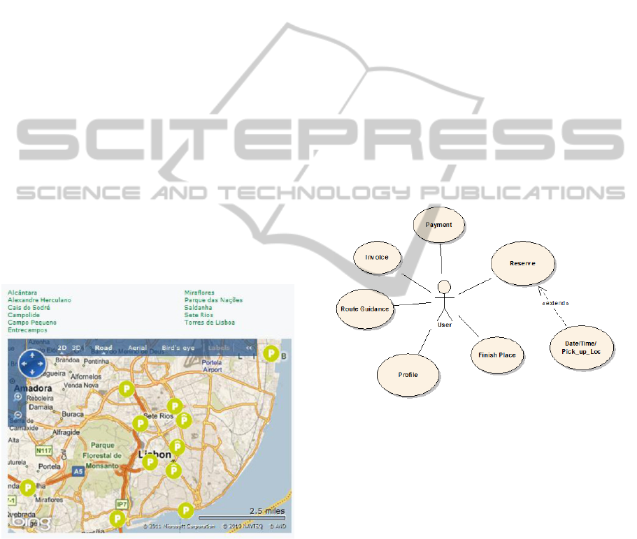
(Steininger, 1996). Figure 9 shows eleven car
sharing parking locations in Lisbon, what represents
a reasonable implementation of car sharing
initiative. Car sharing services are managed by
companies, like short term car rentals. Car Sharing
Organizations (CSO) usually manages a fleet of
vehicles dispatched in several predetermined parking
lots. Members have access to any vehicle at any
time, given that they have made a reservation in
advance. Car keys are usually located in a safe-
deposit box located near the parking lot. Users can
keep the vehicle during a fixed period of time that
can vary from one hour to several days. At the end
of the rental period, the vehicle has to be returned to
a parking lot (usually the one where the car was
taken). Traveled distances and rental durations are
recorded and used for the billing of every user (fees
depend on the total duration and mileage) (Barth and
Todd, 2001).
Figure 9: Car Sharing Parking Places Available in Lisbon,
Status Jully 2011.
Some studies have been conducted to estimate the
potential of car sharing in urban transportation and
changes in transportation behavior when a car
sharing service is available (Lee, 1998), (Cervero,
2002) and (Steininger, 1996). Cervero et al.
(Cervero and Wu, 2002) state that this mode could
attract users towards individual car ownership for
the San Francisco area. Other authors indicate that,
on contrary, CSO helps to decrease car ownership
because some users leave their individual car to
enter the system. Positive impacts of car sharing on
travel demand and on greenhouse gases (GHG)
emissions were also reported by Morency (Morency
et al., 2007). Most of these studies are based on user
surveys and can hardly characterized long run use of
car sharing. Barth et al. demonstrated the
potentialities of using individual data collected in a
multi-station shared vehicle system (Barth and Todd,
2001). On a pure economic basis, CSO can be both
viable and profitable (Wright, 2001). Several
systems are running through the world, especially in
Europe (UK, Germany, Italy, Netherlands), in
Canada (Toronto, Montreal, Quebec City) and in the
United States (Seattle, Portland, San Francisco area).
The proposed system is similar to the reservation
slots of a public charging station and it was
developed in a Final Year Project at ISEL (Xavier
and Lourenço, 2011). Main system functionalities
are described in Figure 10.
Figure 10: Use Case for Car Sharing System.
5 BIKE SHARING SYSTEM
Bike share is an emerging urban transportation
concept based on collective paid use of a distributed
supply of public bicycles. It is similar in function
and programming to car sharing initiatives that have
been very successful in several places. In general,
bike sharing consists of strategically distributed
“stations” containing ten to twenty bikes on average,
with a centralized payment/control kiosk.
Customers—who range from one-time users to long
term subscribers, “unlock” a bicycle with a credit
card or smartcard, then ride to any other station in
the city where they can deposit the bike, concluding
their trip. Bike share fills a number of key “niches”
WEBIST2013-9thInternationalConferenceonWebInformationSystemsandTechnologies
60
in the urban travel market and is particularly useful
for relatively short-range travel beyond the length of
comfortable walking distance. Its key advantage is
that it gives virtually everyone access to what in the
past had largely been viewed as a specialized form
of urban transport, promising increased use of bikes
for short-distance travel, helping to decrease
pressure on traffic and transit systems.
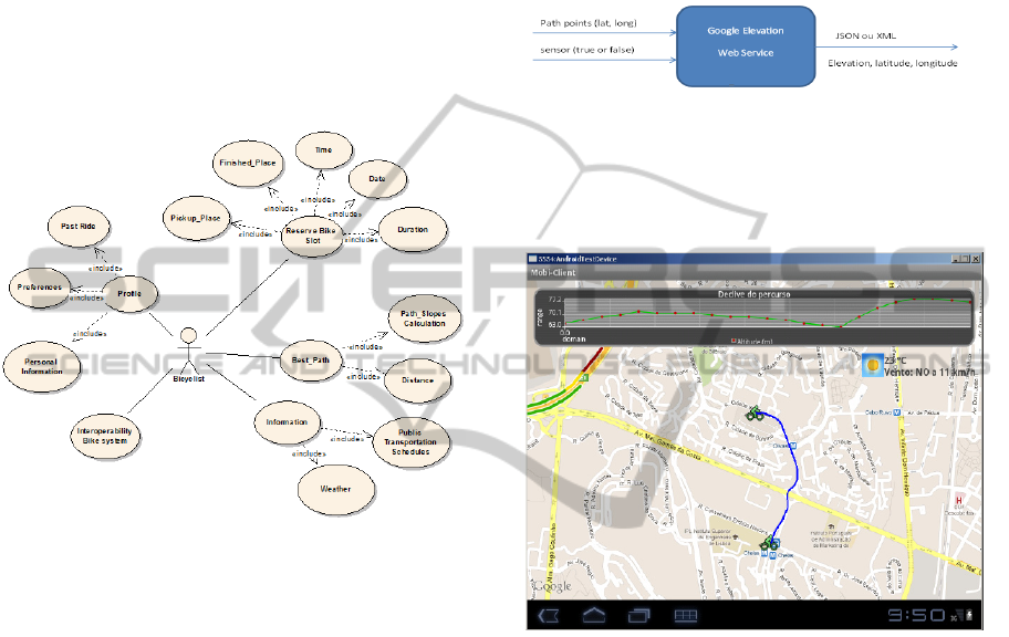
Main functionalities of the proposed Bike
Sharing system are defined in Figure 11 and for
more details see master project at ISEL (Costa,
2010).
Figure 11: Main Bike Sharing System Functionalities.
5.1 Weather
The extremes of weather affect bicycling more so
than any other practical mode of transportation, on
both short-term (day-by-day) basis and longer-term
trends. Extreme heat, extreme cold, and heavy
rainfall are the top weather phenomena leading to
decreased numbers of cycling trips. User Profile can
be used to define if the user wants to use a bike
under certain weather conditions (rain, too cold or
hot).
5.2 Topography
Like weather, topography has an impact on the
willingness of people to use bicycles, although in
this case it is often limited to certain trip patterns
rather than affecting system usage as a whole. This
is apparent in the evaluated European bike share
cities, which regularly exhibit shortages of bicycles
at stations at the tops of hills or steep gradients,
suggesting that many users are riding downhill but
not back upwards. The study of the slope is
particularly important for cyclists and pedestrians.
For the slope Google API allows the following
operations: (1) get the altitude of a particular point;
(2) get the altitude of n points in a straight line path,
where n is the number of samples required; and (3)
get the altitude of a set of points.
Figure 12 illustrates an invocation of Web
service for calculating the profile of a set of points.
Figure 12: Google Web Service Elevation.
Figure 13 presents an application of this service,
where appears the bike path and the elevation in
meters.
Figure 13: Example of a Bike Path with the Elevation in
Meters (Top of Figure).
6 DATA INTEGRATION
External data of Public transportation, Parking
Places availability and location and points of interest
(POI) are merged with public transportation, car and
bike sharing information. Traffic in real time
information is available from road concessionaries,
but outside these organizations, the access to this
information is most of times denied. We propose an
XML file is an approach of future data integration
from different source providers.
6.1 Looking POI with Guidance
The user of Integra System can: (1) get directions;
(2) Points of Interest (POI); (3) get
recommendations on his journey using public
IntegraSystem
61
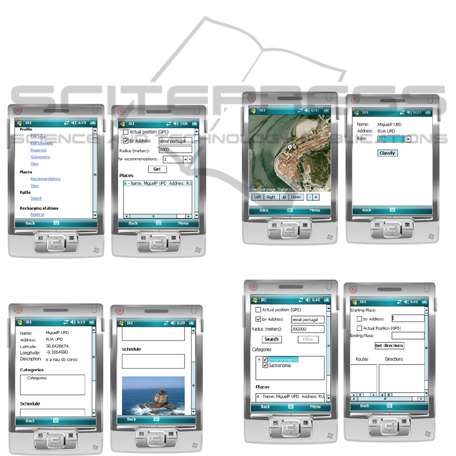
transportation.
After user login (authentication), there is a menu
where the driver selects which operation he wants to
make; this is organized as Figure 14 (left side). If he
wants to know possible interest places, from
Recommendations tab Places, he has the screen
shown in Figure 14 (right side). The user defines
which region the system should consider introducing
the geographic center and radius, which can be
obtained using GPS or an address. Pressing the
button Get recommendations are obtained, and in
this case the user wants to know Points of Interest
(POI) near Seixal, in Portugal, considering a radius
of 2 km. At the bottom of the screen the user will
find the recommendations identified by the name
and address of the location of interest. The user can
get more information about the location of interest
selected by pressing the Info option from the menu.
Figure 14: Main Application Screen and Search for POI
(Points of Interest).
Figure 15: Screen for POI (Points of Interest).
Figure 15 shows the screens to identify a POI.
Information from a point of interest is constituted by
its name, address, latitude, longitude, brief
description, associated categories, hours of operation
and a display picture. In the user classification menu
option, the user can rate the point of interest in order
to help future recommendations to himself and to
other users.The screen lets you annotate/classify the
site of interest, with a degree of satisfaction, such as
"Good." The following Figure 16 (left side)
represents the screen. If the user wants help
geographically he can access it from Map menu to
display the selected site of interest, as is visible in
the Figure 16 (right side). The site contains an
identifier of interest (in this case is A), and in this
screen the user has the ability to navigate the map, as
well as zoom in and zoom out. In the menu he can
change the map type view (Hybrid, Roadmap, and
Satellite).
Figure 16: Visualization and Classification of POI.
Figure 17: Get POI (Points of Interest) and get directions
of Interest).
If he does not like the recommendations generated,
he can always get all the sites in a given area by
WEBIST2013-9thInternationalConferenceonWebInformationSystemsandTechnologies
62

accessing the item in the Places tab View. This
screen is similar to the screen that lets the user get
recommendations of sights, but this one shows all
the sites in a given region with the possibility of
filtering according to the categories of places of
interest, as shown in Figure 17 (left side). After the
user selects possible sites of interest to visit during
the holidays, he needs to know which route to use in
order to visit this place of interest. The screen is in
the following Figure 17 (right side).
6.2 Public Transportation Data
Integration
Information on public transport is available to the
system in the form of an XML file that contains
position information of the geographic locations of
the transports stops (result of data integration
process). The recommendation system submits the
items collection of items for the
PublicTransportService that identifies each item to
its proximity to an interface with public transport. If
yes, the property nearPublicTransport item is placed
with the value of one. The connection to an
information system is made by public transport
component PublicTransportAdapter, see (Ferreira et
al., 2011a).
6.3 Parking Places
The booking parking places is based on a system for
management of reserves (Sistema para Gestão de
Reservas - SGR), that allows driver’s mobile devices
to communicate and performs reservations. To
communicate with the SGR should be used a
technology that allows synchronous communication.
The Integra system is prepared to communicate with
the SGR with a WebService. The SGR responds to
mobile device communication response with a
reservation confirmation, or with a warning
indicating the unavailability parking slots. One of
the issues that arise when proposing an SGR is the
possibility of drivers failed to attend on time (or
even did not show) to a reserve performed. The SGR
must implement mechanisms to minimize the impact
of slots are being reserved, and then run out by
failure of the driver. One possible solution is to
implement a scoring system, which penalizes drivers
with one point in their record when they fail to
reserve a charging slot. When the driver reaches
three points, equivalent to three failures, the driver
has to go to an operator and try to reactivate his/her
access to the SGR.
The diagram in Figure 18 illustrates how the
SGR can be implemented with a system of penalty
points. The information is centralized in the SGR,
communicating with all operators, which also allows
the exchange of information on penalty points,
making the system more efficient. The SGR is
prepared to follow a business model that is
implemented with a slot reversion, failures penalties
and a waiting of reservations of 5 minutes
(administrator configurable time). The same
approach and software module is used for parking
places reservation.
Figure 18: SGR Penalty Points to Avoid User Reservation
Failures.
7 TRANSPORTATION BEST
ROUTE ADVICE
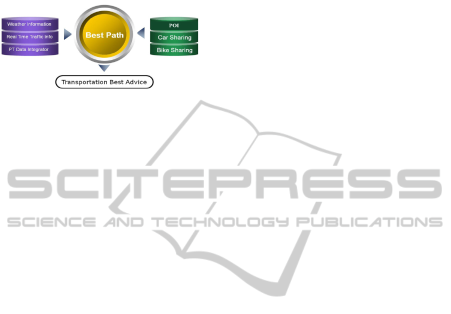
Integra System, can give the best advice in terms of
a diversity of options: public transportation from
several operators, car and bike sharing system, see
Figure 19.The system can be configured to give the
faster option to go from point A to B. This could
imply a mixture of options. Also best advice could
be the cheapest option.
All public transportation data (to the Lisbon
area) were exported to a graph, where the arc length
is defined by the time that it takes to go from one
node arc to the other. The same procedure is applied
for car sharing, POI and bike sharing systems. With
all information in a graph, the best path algorithm,
described in (Ferreira et al., 2011a), can be applied.
The big issue is the matrix size that could increase a
lot with a large diversity of options, and could
generate computer memory problems on handling
this matrix. Some heuristics were defined to speed
up this process. The arc weight can be constructed
from a diversity of options, time, price and C0
2
IntegraSystem
63
emissions. Next Sections explores this issue from a
perspective of a green policy.
Figure 19: Integra Transportation Best Advice.
Also this integrated approach of a diversity of
systems, with geographic information, could be
important for transportation planners or to political
decisions regarding transportation. The main idea is
to adapt arc weight to a combination of items that
could reflect an environment policy. Arc node
reflects time, price and CO
2
emission price and a
good investigation topic is to find the best
combination between time, price and CO
2
emissions
price, in order to define the ‘best’ weight of arc path.
This weight could also include a parameter function
of city traffic conditions (overload paths should be
more penalized). The system has potential to work
and deal with different source diversity. This idea is
materialized in a final year project at ISEL
(Marques, 2011). Different approaches can be
integrated in arc weight calculation: time, price, and
a weight related with CO
2
emissions.
8 CONCLUSIONS
The focus on this work is aligned with the
“Integra Concept” (http://www.start-project.eu/en/
Integra.aspx), whose aim is to provide a single brand
that links together and provides information on the
different public transport operators across the
Atlantic regions. The queries and answers to them
should reflect a single data model. The existence of
this common data model takes the software
applications with the difficult task of dealing with
several technologies and their data schemas.
Different public transportation systems can be added
from the end user point of view. Also, this
integration allows the creation of mobile systems
oriented for tourism purposes. Another main goal of
Integra is to provide guidance to “low budget
tourism”, helping tourists to reach POI (Points of
Interest) by public transportation.
Integra System is based on a emergent approach
the “cooperative transportation infrastructure
integration”, by providing the driver with a
collaborative holistic approach of different public
transportation infrastructure sources that can be
combined with real traffic information (not
described in this work, see (Ferreira et al., 2011a),
parking places, to support the driver decision-
making process or motive the usage of Public
transportation.
REFERENCES
Barth M. J. H., Todd, M., (2001). Performance evaluation
of a multi-station shared vehicle system. IEEE
Intelligent Transportation Systems, Oakland, CA.
Bizer C. P., (2009). The D2RQ Plattform - Treating Non-
RDF Databases as Virtual RDF Graphs. Available at
http://www4.wiwiss.fu-berlin.de/bizer/d2rq/
Cervero R., (2002). City CarShare: Assessment of
Intermediate Travel-behavior. Impacts Institute of
Urban and Regional Development, University of
California, Berkeley.
Cervero R., Wu K., (2002). Evidence from the San
Francisco Bay Area, 1980-90. The City: Economic
structure and change in the Western city 35 (7), 318.
Costa D., (2010). Bike and Car Sharing System. MSc
dissertation – ADEETC – ISEL, Lisbon.
Domingues D., (2010). SITP – Sistema de Informação
sobre Transportes Públicos. Final Year Project at
ADEETC – ISEL, Lisbon.
Ferreira J. C., Filipe P., Silva A., (2011a) Multi-Modal
Transportation Advisor System in proceedings of the
1st IEEE FISTS Forum, July 2011 in Vienna Austria.
Ferreira J. C., (2011b). Green Route Planner in
proceedings of the International Workshoop on
Nonlinear Maps and their applications (NOMA11),
from 14 to 16 September, in Évora, Portugal,
Lee A. T., (1998). Impact of the Car Sharing Scheme on
mode choice. Proceedings of the 1998 Conference on
Traffic and Transportation Studies - ICTTS. A. R. V.
USA. Beijing, China: 508-517.
Marques M., (2011). Green Route-Assistente ‘verde’ em
viagens na cidade. Student Miguel Marques nº 24676,
Final Year Project, ADEETC-ISEL, Lisbon.
Morency C., Trépanier M., Agard B., Martin B., Quashie
J., (2007). Car sharing system: what transaction
datasets can tell us regarding the user behaviors, The
10th International IEEE Conference on Intelligent
Transportation Systems - ITSC 2007, Seattle,
Washington, USA, Sept. 30-Oct. 3, 2007.
Steininger K. W., (1996). Car-sharing organizations - The
size of the market segment and revealed change in
mobility behavior. Transport Policy 3.
Wright, (2001). The Carlink II pilot program: Testing A
commuter-based carsharing model. IEEE Intelligent
Transportation Systems Proceedings, Oakland, CA.
Xavier A., Lourenço N., (2011). CarSharing. Final Year
Project, ADEETC-ISEL, Lisbon.
WEBIST2013-9thInternationalConferenceonWebInformationSystemsandTechnologies
64
